|
Ranger |
|
|
Northern Territory, NT, Australia |
| Main commodities:
U Au
|
|
 |
|
|
 |
Super Porphyry Cu and Au


|
IOCG Deposits - 70 papers
|
All available as eBOOKS
Remaining HARD COPIES on
sale. No hard copy book more than AUD $44.00 (incl. GST) |
|
|
The Ranger unconformity-style uranium deposit is located in the Alligator Rivers uranium field, some 250 km east of Darwin in the Northern Territory, Australia (#Location: 12° 41 'S, 132° 55'E).
The Ranger orebody was discovered in late 1969, and following ore delineation and construction, mining commenced in 1980, reaching the planned full uranium oxide production rate in 1981. The original orebody was completely mined out by the end of 1995, although some stockpiled ore remained. Mining of a second orebody, "Ranger 3" (or No 3 Orebody), began in 1997 and was completed in late 2012. Processing of stockpiled ore continued until January 2021 when the operation closed, although rehabilitation and remediation continued. Both deposits were exploited by open pit mining.
The Ranger deposits are located in the north-eastern part of the Paleoproterozoic Pine Creek Geosyncline which overlies Archaean basement. The Paleoproterozoic comprises the 2470 to 1800 Ma basement Nanambu Complex granite, gneiss and schists. The overlying Cahill Formation comprises a lower unit which consists of quartz-schist, mica-schist, para-amphibolite, calc-silicate and carbonate with a regional northerly strike and dip of 15 to 40°E. An upper unit represented elsewhere has been eroded in the region around Ranger and the lower Cahill Formation is unconformably overlain by the Mesoproterozoic (~1650 Ma) Kombolgie Sub-group of the Katherine River Group, withinthe McArthur Basin. The Kombolgie Subgroup is 1000 to 1500 m thick and is made up of a lower and upper sandstone, composed of conglomerate, sandstone and quartz arenite, separated by the Nungbalgarri Volcanic Member. The lower unit contains volcanic intervals, including basalt, tuff and tuffaceous siltstone. Regionally, the Nungbalgarri Volcanic Member is up to 200 m thick and comprises trachy-basalt, dacite and rhyodacite occurring as massive flows that are vesicular and amygdaloidal near top, with columnar jointing, rare pillow structures and rare porphyritic olivine dolerite dykes.
In the main ranger string of deposits, the stratigraphy is as follows, from the base (Kendall, 1990):
Footwall sequence which is part of the Nanambu Complex, comrpising a variable mixture os schist, gneiss, micro-gneiss and granitic rocks, which in the main No. 1 mine has been altered chloritised and sericitised gneisses and schists laterally and vertically away from the orebody.
Lower Mine sequence - a thick sequence of interbedded carbonates, schists and cherts. The carbonates, which are up to 300 m thick, ranges in composition from magnesite to dolomite, are divided into a lower and upper unit separated by the lenticule schist unit. The lower carbonate is essentially magnesian marble. The schist consists of quartz, chlorite and sericite. The upper carbonate is an impure dolomite with interbedded chlorite schist. Below the mineralised zone of No. 1 Orebody the Lower Mine Sequence thins to <100 m, with the upper carbonate and some of the lower having been silicified to produce a jasperoid chert. Some of the lower carbonate has been replaced by massive chlorite. Uranium mineralisation in the Lower Mine Sequence is restricted to the zones of chlorite alteration and the lenticule schist.
Upper Mine sequence - comprises a 500 m thick sequence of quartz-feldspar-biotite schists, micro-gneisses (altered to quartz-chlorite schist) and irregular carbonates. Discrete carbonate bands are found within the unit, originally believed to have been black shales. The graphitic schists in the central disturbed zone contain high grade uranium mineralisation. Away from the disturbed zone there is no apparent association between graphite and uranium.
Hanging wall sequence - a group of micaceous quartz-feldspar schists with intercalated amphibolitic units and garnetiferous horizons, the basal 50 m of which contain finely disseminated magnetite.
Intrusives - in the mine area are largely pegmatite and dolerite dykes. The dolerite dykes, believed to be part of the Oenpelli Dolerite, are thought to have intruded during, or just after mineralisation.
The Lower and Upper Mine and Hanging wall sequences all belong to the Cahill Formation and are unconformably over lain by the Kombolgie Formation.
There are two main orebodies. The No 1 Orebody is localised in a discrete basin shaped structure formed by the dissolution of carbonate and thinning of the host unit. It is represented by two different grade populations. The first averages 1% U3O8 and occurs as four parallel vein or reef structures within the Upper Mine Sequence recognisable by intense brecciation and chloritisation. The second averages 0.15% U3O8 and includes patchy mineralisation in the Lower Mine Sequence and as lower grade halos surrounding the veins within the Upper Mine Sequence. The No. 1 orebody was mined out in the early 1990's.
The No 3 Orebody occurs as a thin 2 to 3 m thick, shallow dipping high grade (up to 8% U3O8) body of mineralisation against a 5 to 10 m thick chert unit developed at the Lower Mine Sequence to Upper Mine Sequence boundary, accompanied by intense brecciation. Above this zone in the Upper Mine Sequence there is a wider zone of weakly brecciated chloritic schist hosting mineralisation that averages 0.15% U3O8. The remainder of the Upper Mine Sequence is not brecciated, is weakly chloritised and contains finely disseminated pitchblende. There is no evidence of carbonate dissolution at this orebody.
Gold is present as a zone of up to 1 g/t Au in the higher grade uranium mineralisation, while 0.5 g/t Au is an average for the remainder of the uranium mineralised Upper Mine Sequence.
Uranium mineralisation is principally present as pitchblende, is intimately associated with chloritisation and occurs as sooty smudges on joint planes and foliations. Secondary uranium minerals saleeite, sklodowskite, gummite and metatorbenite are common in the oxidised zone.
Since the commencement of mining in 1981 to 1989, 19 400 t of U3O8 were produced from the original reserve of 52 000 tonnes in the No. 1 and No. 3 Orebodies (Brown, 1990).
In 1990 the No 3 Orebody had reserves of 35 Mt @ 0.2% U3O8 for 70 000 t of U3O8 (Browne, 1990).
In December 2008, the remaining reserves and resources at Ranger were (ERA Media Release, Jan. 2009):
Proved + probable reserves (0.06% U3O8 cut-off) - 30.19 Mt @ 0.23% U3O8 = 43 996 tonnes of U3O8 plus, in addition to the reserves,
Measured + indicated + inferred resources (0.02% U3O8 cut-off) - 128.26 Mt @ 0.09% U3O8 = 115 368 t U3O8.
Ranger 68 is 20 km NNW of Ranger 1 and comprises 1.5 Mt @ 0.357% U3O8 at a cutoff of 0.1% U3O8 for over 5000 tonnes of contained U3O8. All mineralisation is hosted by the Cahill Formation, which is essentially a chloritised and sericitised schist, gneiss and micro-gneiss with intercalated thin carbonates and local amphibolitic gneiss, overlying a massive carbonate unit. The schist contains coarse breccias that host the bulk of the mineralisation which occurs as sooty pitchblende, with sooty chalcocite in the same breccias. Most of the Cahill Formation above the deposit is unconformably overlain by up to 90 m of Cretaceous Bathurst Island Formation conglomerate and sandstone.
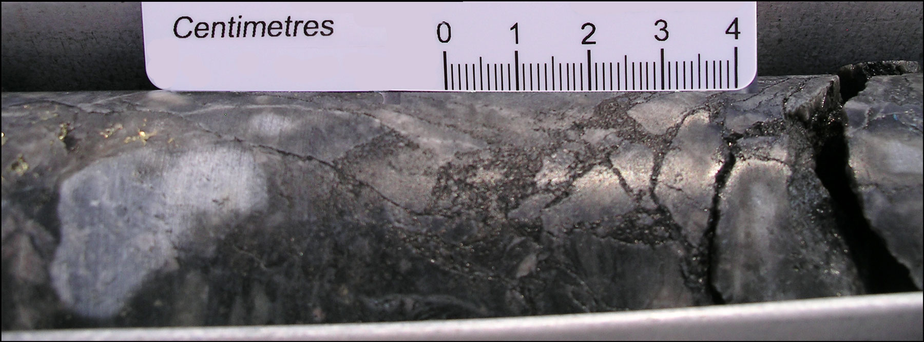
Image above: Pitchblende matrix breccia in siliceous host at Ranger. Image by Mike Porter, 2009.
The most recent source geological information used to prepare this decription was dated: 1990.
This description is a summary from published sources, the chief of which are listed below.
© Copyright Porter GeoConsultancy Pty Ltd. Unauthorised copying, reproduction, storage or dissemination prohibited.
|
|
|
Selected References:
|
Beaufort, D., Patrier, P., Laverret, E., Bruneton, P. and Mondy, J., 2005 - Clay Alteration Associated with Proterozoic Unconformity-Type Uranium Deposits in the East Alligator Rivers Uranium Field, Northern Territory, Australia: in Econ. Geol. v.100, pp. 515-536.
|
Browne, A.L.L., 1990 - Ranger 68 Uranium deposit: in Hughes F E (Ed.), 1990 Geology of the Mineral Deposits of Australia & Papua New Guinea The AusIMM, Melbourne Mono. 14, v.1., pp. 795-797.
|
Derome D, Cuney M, Cathelineau M, Fabre C, Dubessy J, Bruneton P, Hubert A 2003 - A detailed fluid inclusion study in silicified breccias from the Kombolgie sandstones (Northern Territory, Australia): inferences for the genesis of middle-Proterozoic unconformity-type uranium deposits: in J. of Geochemical Exploration v80 pp 259-275
|
Eupene G S, Fee P H, Colville R G 1975 - Ranger One uranium deposits: in Knight C L, (Ed.), 1975 Economic Geology of Australia & Papua New Guinea The AusIMM, Melbourne Mono 5 pp 308-317
|
Hein, K.A.A., 2002 - Geology of the Ranger Uranium Mine, Northern Territory, Australia: structural constraints on the timing of uranium emplacement: in Ore Geology Reviews v.20, pp. 83-108.
|
Kendall C J 1990 - Ranger Uranium deposits: in Hughes F E (Ed.), 1990 Geology of the Mineral Deposits of Australia & Papua New Guinea The AusIMM, Melbourne Mono 14, v1 pp 799-805
|
Ludwig K R, Grauch R I, Nutt C J, Nash J T, Frishman D, Simmons K R 1987 - Age of Uranium mineralization at the Jabiluka and Ranger deposits, Northern Territory, Australia: new U-Pb isotope evidence: in Econ. Geol. v82 pp 857-874
|
Maas R 1989 - Nd-Sr isotope constraints on the age and origin of unconformity-type Uranium deposits in the Alligator Rivers Uranium Field, Northern Territory, Australia: in Econ. Geol. v84 pp 64-90
|
Wilde A R, Mernagh T P, Bloom M S, Hoffmann C F 1989 - Fluid inclusion evidence on the origin of some Australian unconformity-related Uranium deposits: in Econ. Geol. v84 pp 1627-1642
|
|
Porter GeoConsultancy Pty Ltd (PorterGeo) provides access to this database at no charge. It is largely based on scientific papers and reports in the public domain, and was current when the sources consulted were published. While PorterGeo endeavour to ensure the information was accurate at the time of compilation and subsequent updating, PorterGeo, its employees and servants: i). do not warrant, or make any representation regarding the use, or results of the use of the information contained herein as to its correctness, accuracy, currency, or otherwise; and ii). expressly disclaim all liability or responsibility to any person using the information or conclusions contained herein.
|
Top | Search Again | PGC Home | Terms & Conditions
|
|


