|
White Pine, Presque Isle/Copperwood |
|
|
Michigan, USA |
| Main commodities:
Cu Ag
|
|
 |
|
|
 |
Super Porphyry Cu and Au


|
IOCG Deposits - 70 papers
|
All available as eBOOKS
Remaining HARD COPIES on
sale. No hard copy book more than AUD $44.00 (incl. GST) |
|
|
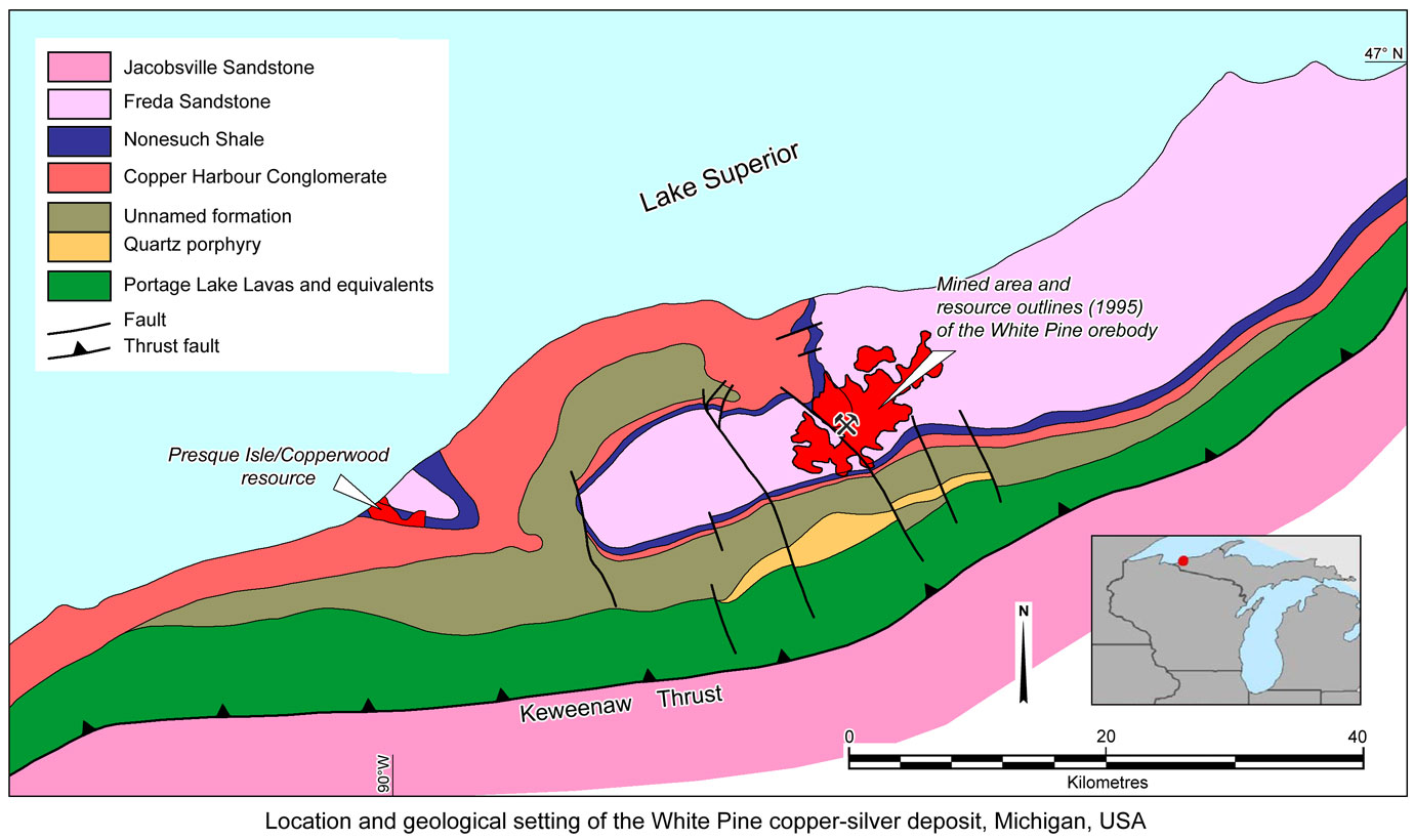
The White Pine ore deposit and associated mineralisation is hosted by the Mesoproterozoic, 1100 Ma, Oronto Group of the Keweenawan Supergroup within the northeast trending, curved, Mid Continent Rift, on the Keweenawan Peninsular of northern Michigan, USA, near the town of White Pine, 340 km NE of Minneapolis-St Paul (#Location: 46° 45' 47"N, 89° 34' 3"W).
The copper-bearing Nonesuch Shale was discovered in an outcrop in the bed of the Little Iron River, Michigan in 1865. An attempt was made to exploit the deposit soon after at the Nonesuch Mine. However, ore grades were too low, the ore mineral particles too fine, and the presence of copper as sulphides made the shale deposits uneconomic, although repeated attempts were made to mine these shales at the Nonesuch Mine. The original White Pine mine began operation in 1879, concentrating on the fine-grained native copper in the sandy portion of the Copper Harbour Conglomerate underlying the main sulphide mineralisation. In late 1920, the mine was closed because of a recession and depressed copper prices. It was subsequently purchased by the Copper Range Company in 1929, and a 23 year program of research undertaken to determine an economic method to recover the copper sulphide from the Nonesuch Shale. The outbreak of the Korean War in 1950 forced the US to consider increasing domestic sources of copper, and a government loan was offered to the Copper Range Company to commence mining. Construction commenced in 1952 and in March 1953, large-scale mining began when the first ore hauled was hauled from the White Pine mine portal, 3.2 km east the old Nonesuch mine. In January 1955 the first copper was poured from the mine smelter. The mine produced more than 1.8 Mt of contained of copper and 140 t of silver before its closure in 1995.
The White Pine area is located on the flank of the 2000 km long, horseshoe shaped Mesoproterozoic Mid-continent Rift System (MRS) of North America. The MRS is fringed by older Palaeo- and Mesoproterozoic rocks set within the Archaean basement of the Canadian Shield, and is filled by an up to 30 km thick package of Keweenawan Supergroup volcanic and clastic sedimentary rocks. Keweenawan Supergroup rift phase rocks, which comprise tholeiitic flood basalts with minor interbedded red conglomerate and sandstone, were deposited within a 150 km wide rift. Keweenawan Supergroup post-rift phase rocks comprise basin-sag fluvial and lacustrine clastic rocks of the Oronto Group. The last phase of the MRS, from 1.07 to 1.05 Ga, was characterised by a partial inversion of the original graben bounding normal faults into major reverse faults, accompanied by the deposition of mature clastic sedimentary rocks of the Bayfield Group. The present-day dip of Keweenawan Supergroup strata is a result of syn-depositional sagging and tilting related to faults and folds associated with the compression event.
The rift-phase volcanic rocks exhibit evidence of pervasive alteration by metamorphic fluids which circulated through a network of faults and fractures developed during late rift compression, and are interpreted to be responsible for leaching and redeposition of native copper in the volcanic-dominated rocks of the Keweenawan Peninsula and sulphide copper in the base of the Nonesuch shale, host to the White Pine deposit. The Keweenawan Supergroup mafic volcanic rocks host significant historically mined native copper deposits - see the separate Keweenawan Native Copper - Calumet-Hecla, Quincy, Atlantic, Kingston record for details.
Subsequent to the compression event, the area was subjected to erosion, exposing the copper deposits, which were subjected to a long period of downward percolating ground waters before being covered following a late Cambrian marine transgression and covered by a thick Phanerozoic sequence. A period of non-deposition and erosion persisted from the middle Jurassic to the Pleistocene when the cover was again removed from Precambrian rocks of the western Upper Keweenawan Peninsula by Pleistocene continental glaciers beginning ~2 m.y. ago.
Structure
The White Pine orebody is flat lying to gently dipping, generally less than 15°. On its southwestern margin there is a zone of south dipping thrust faults which cut and disrupt the ore near its margin and locally produce steeper dips. This zone of thrusting is generally parallel to the major north dipping Keweenaw Fault some 12 km to the south, but dips in an opposite sense. Throughout the mine area there are also a number of earlier reactivated high angle faults which displace the orebody by 10 to 40 m. Many of these are believed to be growth faults that can be shown to have influenced the facies distribution of the host rocks. The largest of these structures, the White Pine Fault, offsets the orebody to the southwest by up to 550 m downwards and a lateral displacement of up to 900 m. An asymmetric anticline passes through the core of the deposit with an axial trend paralleling the White Pine Fault. On the southern limb, adjacent to the White Pine Fault, dips approach vertical, in contrast to the generally shallow dips elsewhere in the mine. These faults do not have a consistent trend, but vary from NE to NW, possibly influenced by folding. On a finer scale there are frequent smaller parallel faults that offset the orebody from 1 to 2 m, requiring close geological control.
Regional Setting
The regional succession may be summarised as follows:
Archaean and Palaeoproterozoic basement - including Superior Iron Formation sequences and Intrusives rhyolitic and granitic rocks of 1800 to 1850 Ma and 1760 Ma in age.
Unconformity.
Barron, Baraboo, Sioux and Waterloo Quartzite, deposited as widespread thin sheets of very pure quartzites over substantial areas, between 1760 and 1500 Ma.
Unconformity - Intrusion of granite, syenite and anorthosite dated at 1500 Ma.
Keweenawan Supergroup, comprising,
- Sibley Series, 200 m thick - a thin basal conglomerate, overlain by white to yellowish sandstone with thin interbeds of limestone and chert, and overlain by red to grey carbonate and shale. These rocks are from 1300 to 1350 Ma and are locally overlain by other thin quartzites which are believed to be 1200 to 1100 Ma in age.
- North Shore Volcanic Group on the NW shore of Lake Superior and the Powder Mill Group to the south of White Pine - these sets of mafic volcanics developed above the basal Sibley Series are found on either margin of the Mid Continent Rift. They are apparently cut by and overlie the Duluth and related Gabbro Complexes.
- Duluth Gabbro Complex to the NW of Lake Superior and the Mellen and Mineral Lake Layered Mafic Complexes to the south of White Pine. These two sets of mafic intrusives appear to be related to the margins of the Mid Continent Rift zone. The Duluth Gabbro in particular represents a considerable volume of rock. They comprise gabbro, anorthosite and peridotite and are interpreted to be related to the volcanism of the Keweenawan Supergroup.
- Portage Lake Lava Series, up to 9000 m thick - a succession of tholeiitic subaerial flood basalts with 3 to 10% interflow sandstone and conglomerate as beds from a few cm's to tens of metres in thickness. The clasts within these sediments are predominantly Keweenawan felsic volcanics, with rare mafics or pre Keweenawan rocks. The sediment interbeds increase in abundance upwards within the sequence and grade into the overlying Copper Harbour Conglomerate. Individual flows and sediment bands can be mapped over extensive lateral distances, up to tens of kilometres. The basic lava flows extend away from vents distributed along the axis of the of the main Mid Continent Rift. Dyke sets parallel to the rift axis and the wide extent of most flows suggest that fissure fed eruptions predominated with few central volcanoes. Al rich olivine tholeiite predominates, followed by weakly alkaline olivine basalt and large quantities of high Fe tholeiite and apparently minor felsic varieties. Within different parts of the rift, equivalent volcanics are mapped under a variety of names, including the Chengwatana Volcanic Group to the southwest in the core of the rift, the North Shore Volcanics to the NW of Lake Superior above the Duluth Gabbro and as the Osler Series in Ontario. Similar volcanics are mapped on islands in, and at various points around, the lake.
On the 1200 and 1050 Ma Keweenaw Peninsular these volcanics have been extensively altered in the more permeable sections (ie. breccias, amydaloidal zones, conglomerates and sandstones, and along faults and fractures) into three zones with near horizontal boundaries. These comprise a lower epidote-albite-quartz-chlorite, a middle pumpellyite-albite-prehnite and an upper prehnite-albite-laumantite zone.
- Unnamed Formation, also known a the Porcupine Volcanics which is 0 to 4000 m thick - comprises mafic and felsic flows in the form of a volcanic dome overlying the Portage Lake Lavas. This dome is centred immediately adjacent to the White Pine orebody, between it and the Presque Isle Syncline which hosts another similar Cu deposit. The maximium development is between these two deposits and it then thins to both the north and south, having effectively lensed out some 40km to the north of White Pine and a similar distance to the south of Presque Isle. The volcanics are predominantly rhyolitic in composition and include a number of mapable subsidiary domes. It has been suggested that the thickest section of this unit may represent an old buried 'pre Copper Harbour Conglomerate' caldera.
Oronto Group, which comprises the following three formations,
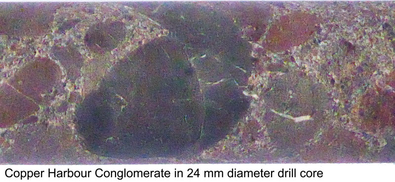 - Copper Harbour Conglomerate, 100 to 1800 m thick - to the north and south of White Pine the Portage Lake Lavas and their intercalated conglomerates and sandstone grade up into the Copper Harbour Conglomerate. It is a red-brown basinward thickening wedge of dominantly conglomerate with volcaniclastics, sandstones and lesser siltstones. The conglomerates are composed predominantly of felsic volcanic with lesser mafic clasts and minor chert jasper and crystalline basement lithologies, interbedded with lithic sandstones. Clasts are rounded to subrounded and vary from 1 to 20 cm in diameter. There is a well developed thick bedding on a 0.1 to 3 m basis, each bed having a different grain size matrix and a corresponding variation in clast size and abundance. The matrix varieties range from a grit to a fine silt. Cross bedding is also evident. Calcite veining is found in the conglomerate bands. Some stromatolitic zones are reported from sections of the basin as are gypsum clasts.
- Nonesuch Formation, - the host to the White Pine mineralisation which is described below.
- Freda Formation, >3700 m thick, composed of red to reddish-brown, ferruginous, fluvial sandstone, siltstone and mudstone.
- Jacobsville Sandstone, >3000 m thick, comprising a red to white, coarse to fine-grained, feldspathic and quartzose sandstone, interpreted to have been deposited in a shallower flanking basin to the east of both the Keweenaw Fault and the main rift zone. This fault marks the contact between the Jacobsville Sandstone and the Portage Lake Volcanics to the west. This sandstone, while interpreted to be younger than the Freda Formation, although it unconformably overlies Palaeoproterozoic and Archean rocks further to the east. The Keweenaw fault began as a normal fault controlling the eastern edge of the rift during extension, although subsequent inversion of the rift transformed it into a SE vergent high angle reverse fault.
Geology
The orebody is contained within the lower 5 m of the Nonesuch Formation and locally the top 3 m of the underlying Copper Harbour Conglomerate. The host Nonesuch Formation sequence in the mine area is as follows, from the base:
Lower Sandstone, 1.5 to 12 m thick - this is in fact the upper most unit of the Copper Harbour Conglomerate. It comprises red to greenish-grey, coarse to fine grained sandstone, which is an immature volcanic rich lithic arenite. It ranges from moderately sorted and medium grained to sparsely pebbly, poorly sorted, medium and coarse grained varieties. Although volcanic detritus is abundant, detrital quartz equals it in volume. The clastic iron oxide grains that are common throughout the Copper Harbour Conglomerate are rare or absent in the cupriferous sandstones. Chlorite, quartz and calcite are common cements as locally is black solid carbonaceous matter. The contact with the underlying red sandstone typical of the Copper Harbour Conglomerate is gradational. It has large trough sets of crossbeds and scour channels are common. In places in the upper 0.25 to 1m it becomes finer and more flat bedded. The topography of the upper surface was variable, affecting the thickness and distribution of the overlying Parting Shale.
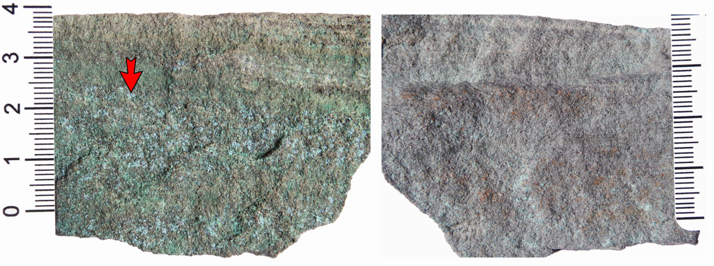 Right. Fresh Lower Sandstone with fine native copper and very finely disseminated sulphides not obvious to the naked eye. Left. Reverse side of the same specimen that has been oxidised with the presence of copper sulphides reflected by pale green copper oxides (e.g., as indicated by arrow head). Scale graduations are in centimetres.
Parting Shale, averages 2 to 2.5 m thick at White Pine, but reaches 9 m in the Presque Isle Syncline. It lenses out to the south in the mine area. At the pinchout, it becomes reddish and coarser grained with the individual constituent beds becoming less distinguishable.
- Lower Transition, a few cm's to a few tens of cm's thick - coarse to fine grained sandstone as in the Lower Sandstone, intercalated with laminae of black shale which increase in proportion until it is the dominant lithology immediately below the overlying Domino. This is generally mineralised with 1 to 3% Cu, mainly in the upper section.
- Domino, from a few cm's to 0.5 m thick - thinly interlaminated pale grey siltstone and black silty shale to argillaceous silstone, laminated on a millimetric basis. It comprises quartz and chlorite in even amounts (20 to 30% each) with other silicate minerals, such as plagioclase and muscovite, all of which are derived from volcanic detritus. This is the main mineralised bed in the Parting Shale usually carrying 3 to 5% Cu.
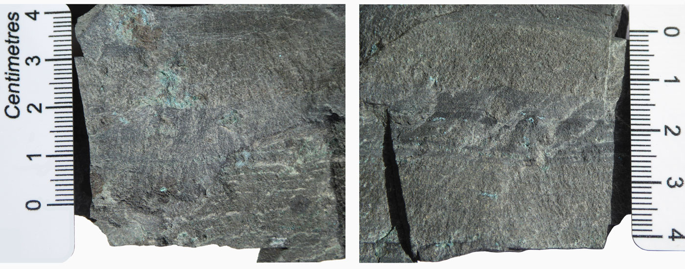 Two specimens of Domino Ore/Mineralisation from the Parting Shale. These samples were collected fresh in 1991 and are partially oxidised by the time of imaging in 2018. Mineralisation occurs as very finely disseminated bornite and chalcocite following coarser beds and fractures and as clots. The horizontal layering in these images is bedding.
- Junior (or JR) Line, 1 mm to 1 cm thick - an extremely sharply defined layer of pink to white calcite which is laterally persistent at the abrupt change from the Domino to Red Massive. It has been traced in drilling over hundreds of square kilometres, but is not present where the Parting shale pinches out.
- Red Massive, approximately 0.5 m thick - massive to broadly bedded faintly reddish to grey siltstone. The boundary with the overlying Dark Grey Massive is gradational, in contrast with the Junior Line at the base. In this transition the colour changes from red to grey over a few, up to 10 cm's. In places this unit carries ovoid nodules from 1 to 2cm in diameter, principally carbonate, with diffuse boundaries and associated pyrite and Cu minerals. In places these resemble subangular clasts.
- Dark Grey Massive (DGM), up to 0.5 m thick - dark grey massive siltstone, broadly and vaguely bedded on a 2 to 5cm basis. Only the colour distinguishes it from the Red Massive. This is the next most important mineralised bed in the Parting Shale, after the Domino. It generally carries 1 to 2% Cu.
- Top Zone, 0 to 0.15 m thick - a thin bedded, well banded unit consisting of layers of grey fine sand to silt alternating with black shale laminae. It is highly variable, not being present in many places, while in others the thickness changes as much as from 1 to 10cm in 10m laterally.
- Tiger, averaging 0.3 m thick - grey to greenish-grey siltstone with red shales interbedded on a 1 to 5cm basis giving a striped appearance. The Top Zone and Tiger are thinnest at White Pine, but thicken to 2m some 10km to the northwest.
Upper Sandstone, 0.6 to 1.4 m thick - a pebbly medium grained, chloritic, volcanic rich, lithic arenite, very similar in composition to the Lower Sandstone. It has a thin conglomerate band near the base with subrounded to subangular clasts from 1mm to 2cm in diameter. The sandstone is generally medium grained with grit to pebble sized clasts of felsite irregularly spread throughout. Scour channels are obvious as is crossbedding with foresets at angles of up to 20 degrees. In places the scour channels near the base cut into the Tiger with sharp margins and load casts in the Tiger sediments.
Upper Shale, 11.5 m thick - This unit and its constituent beds are closely comparable to the Parting Shale. The main difference is in the more regular lamination and the predominance of finer grained, more argillaceous and more carbonaceous sediments in the Upper Shale. It comprises,
- Upper Transition, a few cm's to a 1 m thick - very similar to the Lower Transition, forming a gradation upwards from the Upper Sandstone into the Thinly. It varies in thickness, ranging from 0.2 to 1 m in several hundred metres laterally.
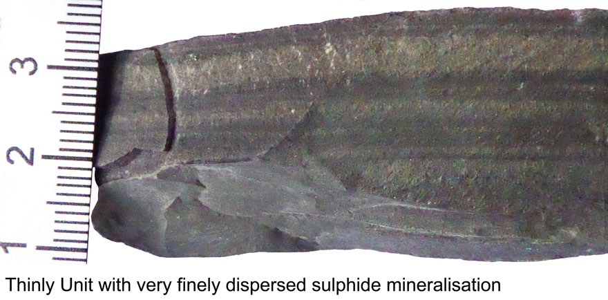 - Thinly, around 30 cm thick - thinly interlaminated pale grey siltstone and black silty shale to argillaceous silstone, laminated on a millimetric basis. It is virtually identical to the Domino and is also the main ore bed in the Upper Shale. The highly mineralised section ranges from a cm's to 30cm in thickness. The Thinly and the higher sections of the Upper Transition together, usually assay from 3 to 5% Cu.
- Brown Massive, around 0.6 m thick - reddish brown to grey massive siltstone, closely comparable to the Red Massive in the Parting Shale. At and near the base, where there is an abrupt change, there is a characteristic band of brown flattened calcite nodules from 5 to 10cm in diameter. These nodules are ghost like with gradational margins. The bedding of the country rock passes through the nodules without a break. The enclosing rock however, has been differentially compacted, indicating that the nodules are a very early diagenetic concretionary cementing feature binding and hardening the sediments prior to compaction and lithification. This layer of calcitic nodules may be an analogue of the Junior Line calcite bed in the Parting Shale.
- Upper Zone of Values (UZV), around 0.5 m thick - a massive to thickly and vaguely bedded dark grey siltstone, closely similar to the Dark Grey Massive of the Parting Shale. This unit carries 1 to 2% Cu in general within the copper zone.
- Widely, 1.5 to 2.4 m thick - widely laminated greenish-grey siltstone with varve like grey shale partings. It is carbonaceous near the base and may carry some Cu values in the lower section comparable to the Upper Zone of Values.
- Red and Grey, 1 to 1.5 m thick - widely laminated greenish-grey siltstone with varve like red shale partings.
- Massive grey siltstone or Tiebel Sandstone, 6.5 m thick - in graded beds 10 to 50 cm thick, and comprises interbedded medium-grey to grey-green, medium- to very-fine-grained, moderate- to well-sorted calcareous sandstone and chloritic-micaceous siltstone and shale. Massive to horizontally stratified and micro-trough cross-bedded sandstone and siltstone with mudstone drapes, shale partings, rip-up clasts, graded beds, fining-upward sequences, and soft-sediment deformation features.
- Stripey, 0.5 m thick - finely laminated black silty shale with white calcite laminae and abundant calcite cement. It occurs as lenticular to planar bedded, medium grey to grey-green, calcareous, very fine-grained sandstone and chloritic/micaceous siltstone and shale with mudstone drapes, partings and load casts. Fining upward to sandy-siltstone and siltstone-shale couplets that are each <1 cm. thick.
- Massive black siltstone, 1 m thick.
- Marker Bed, 3 m thick - crudely- to well-laminated, light-grey to black calcareous siltstone with abundant white calcareous blebs and black to dark gray-green, pyritic shale (laminae >1 mm thick). Siltstone laminae are commonly truncated or discontinuous with numerous load features, giving the unit a blebby appearance.
Remainder of the Nonesuch Shale which comprises up to 200 m more in thickness.
In the southwest section of the mine the Parting Shale, Upper Sandstone and the Upper Shale thin drastically, supposedly onto a positive irregularity of the Lower Sandstone. In this area the Parting Shale thins and pinches out with the almost identical Upper Shale passing down to rest on the Lower Sandstone with an erosive contact comparable to that normally seen at the top of the Tiger. The Upper Shale also thins a little further to the southwest.
Apart from the more structurally complex areas, the grade is extremely even and consistent within the mineralised beds, when present, over large areas covering the whole mine.
Within the mine area calcite is variably and widely spread as veins of 1 to 5 mm cutting across bedding in the ore zone. Dewatering and soft sediment structures are common within the Nonesuch Formation.
Sections of the Upper Shale above the orebody carry kerogen and petroleum which seeps into the mine through fissures and upward drill holes. As such these rocks are essentially oil shales.
Mineralisation
Copper in the vicinity of the White Pine mine has been known since the 1850's and mining was first carried out at the Nonesuch Mine in 1865.
Mineralisation is distributed within the following units (after Johnson, 2014):
• The Lower Transition and Domino, with grades of ~2.5% Cu;
• DGM and to a lesser extent, the Top Zone, with grades of ~1.8 and 1% Cu respectively;
• Upper Transition and Thinly, with grades of ~3% Cu;
• The UZV, with grades of ~1.25% Cu.
Within the White Pine area there are four different zones or styles of mineralisation as follows, in chronological order from the oldest:
Pyrite zone - this zone is widely developed within the carbonaceous facies of the Nonesuch shale and is taken to be a very early diagenetic, bacterial catalysed development. In places it also extends into the uppermost metre or so of the Upper Sandstone. The pyrite is very fine grained, commonly of a few microns and is generally not discernable to the naked eye. However clusters of grains up to a few mm's across are not uncommon while millimetric clusters of very fine framboidal grains are also visible in places.
In the pyrite zone the iron oxides that are characteristic of the Oronto Group as a whole are not evident. It has been suggested that the Fe content is present as pyrite rather than Fe oxides and that the biogenic conversion occurred in early diagenesis. The sulphur isotopes are consistent with a biogenic source while fossil porphyrend (reducing) bacteria have been identified within the carbonaceous sediments of the ore zone.
Bornite Fringe - a fringe of chalcopyrite and bornite forms a blanket over the main chalcocite zone separating it from the overlying pyrite zone. This fringe is generally only a few cm's thick, but may be up to about 0.5 m, and comprises an outer predominatly chalcopyrite layer (next to the pyrite zone) and a bornite rich band (adjacent to the chalcocite).
Chalcocite Zone - this zone comprises the overwhelming bulk of the copper mineralisation at White Pine. Like the pyrite, the chalcocite is very fine grained ranging from 1 to 200 µm, but averaging 2 to 20 µm and is generally the only sulphide present. As such it is very rarely visible to the naked eye, although with experience it is apparently possible to discern a characteristic shade within well mineralised rock. The total amount of sulphide within the pyrite and chalcocite zones are apparently the same. In addition the total Fe in both zones is the same occurring within the chalcocite zone as hematite dust on chalcocite grains, clusters and nodules. The chalcocite occurs interstitially to the detrital silicate grains, while the larger sulphide grains are replacements of some of the silicates. Pseudomorphs after pyrite are occasionally observed on the outer margins of the chalcocite zone.
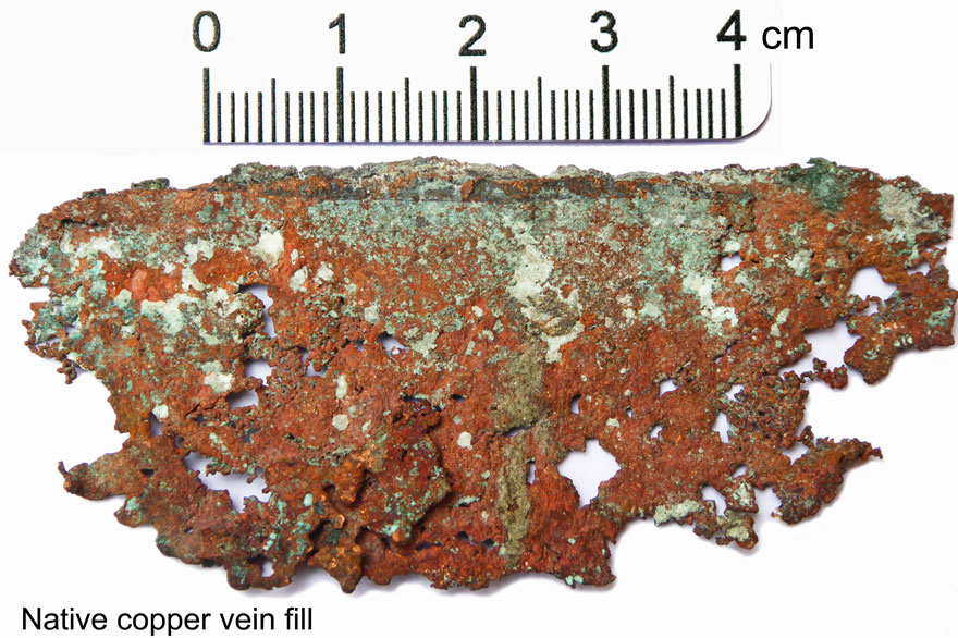 Native Copper Zone - native copper is generally within or just below the chalcocite zone and is largely spatially related to late thrust faulting, particularly in the southwestern section of the mine area. Native copper appears to predominantly represent a second phase of mineralisation which overprints the main first phase chalcocite, and comprises 13% of the Cu in the mine. It occurs as sheets or plates from 0.2 to 5 mm thick within fractures, faults and parallel to subparallel to bedding, within both sandstones and shales, with lateral dimensions of up to several metres, and as disseminated lumps to fine grains within sandstones. Unlike the sulphides, the native copper is readily visible.
While the pyrite is stratigraphically controlled, the copper mineralisation is grossly stratabound but exhibits definite transgressive boundaries. The narrow Bornite Fringe which marks the outer margin of the Cu mineralisation extends from within the Lower Sandstone to above the Stripey Bed in the Upper Shale. Although the Bornite Fringe locally cuts steeply across the host stratigraphy, there is no 'overhang' where fingers of the pyrite zone project laterally into the Chalcocite Zone. There are thinnings of the Chalcocite Zone and hence depressions in the Bornite Fringe surface, such as in portion of the Presque Isle deposit above an unusually thick and strongly mineralised section of the Domino in the lower orebody.
The Bornite Fringe marks the upper limit to which the copper mineralisation permeated into the Nonesuch Formation, apparently from the base upwards until all of the available Cu had been precipitated.
The Chalcocite Zone is not synonymous with ore, it merely represents the volume of rock within which the principal (and virtually only) sulphide present is chalcocite. Within the Chalcocite Zone the distribution of grade is controlled by lithology, with the higher Cu levels being within the more carbonaceous sediments. There is a close correlation between the organic and Cu contents of rocks in the Chalcocite Zone, with the grade within particular beds being very consistent throughout the zone. The Domino and Thinly usually carry 3 to 5% Cu, the Dark Grey Massive and Upper Zone of Values assay 1 to 2% Cu, while the other lithologies within the Chalcocite Zone generally have 0.1 to 0.2% Cu.
It should also be noted that while there are more similarly carbonaceous, pyritic beds in exactly the same setting as the mineralised units of the Parting and Upper Shales, but higher in the Nonesuch Formation and well within the Pyrite Zone, they are not mineralised.
In an precise analogy to the Chalcocite Zone, within the pyrite zone, there is a higher pyrite content within the more carbonaceous beds, commonly with 2 to 3% pyrite compared to 0.5 to 1% pyrite in the grey beds.
The Cu content of a particular well mineralised bed such as the Domino or Thinly is generally 100 to 400 times greater than in the pyrite zone, while even the 'reddish' beds in the chalcocite zone carry more Cu in the Chalcocite Zone than strongly carbonaceous beds in the Pyrite Zone.
The native copper in the mine area appears to predominantly represent a second phase of mineralisation which overprints the main first phase of chalcocite and bornite. Native copper represents 13% of the Cu in the mine. It is more prominent within the southwestern section of the mine in association with the late thrust faulting that predominates there. In this area there are many anomalously high Cu patches in which the higher grades are attributable to the presence of native Cu. In general in this area grades are 20 to 30% higher than those normally encountered in the main first stage mineralisation. The native copper occurs as sheets from 0.2 to 5 mm thick within fractures, faults and parallel to subparallel to bedding. In the same areas there is also an increase in native Cu as macroscopic veinlets and fine disseminations. Sheets of native Cu can be traced along bedding, into thrust faults where they wrap into the thrust, and 'out the other side' to pass along bedding at a different stratigraphic position. In these cases the offset of the sheet of native copper is less than the offset on the fault. This indicates that the introduction of, or at least the formation of, the sheet was contemporaneous with the faulting. Approximately 20% of the Cu introduced in the second phase appears to be in the form of chalcocite which occurs as stockworks around the thrust faults and as lateral extremities to the bedding controlled native Cu bands away from the faults.
It should be noted however that the native Cu developments do not extend beyond the Bornite Fringe of the first stage by more than a metre or so, even though the thrusts can be traced to the surface.
It has been suggested that the second phase of mineralisation is remobilisation. However no area has been identified above, below or lateral to the mined native Cu zones that have been correspondingly depleted to provide the necessary metal. This second phase of mineralisation is taken to be contemporaneous with the native copper mineralisation within the Portage Lake Lava Series on the northern Keweenaw Peninsular, which is post tilting.
All of the Ag in both stages was as native Ag, with there being no relationship between the Cu and Ag grades. It occurs as very discrete bedding plane plates, not associated with chalcocite, although it sometimes occurs adjacent to chalcocite grains, they are generally separated. The introduction of Ag appears to overlap the end of, and continue beyond, the first phase Cu introduction. Similarly in the second phase of mineralisation Ag is a late entrant which persisted after the cessation of Cu introduction, being present as native Ag, generally in discrete veins separate from the Native Cu bands. In the second phase there was also a pulse of Ba mineralisation which overlapped with and continued beyond the Ag pulse. The bulk of the petroleum is also believed to be late second phase, overlapping with the late Cu, Ag and Ba pulses.
Traces of Cd as greenockite (CdS), Zn as sphalerite and Pb as galena are detectable in the Pyrite Zone, although these are each no more than a few hundred ppm, but usually much less.
Many of the fractures in the mine, both the normal and thrust faults and the joints, carry calcite veining which locally also contain barite, Cu sulphides, native Cu and native Ag. These veins are apparently post tectonic but do not influence the overall grade.
From laboratory studies it is suggested that the first stage mineralisation was apparently formed at temperatures of around 100°C.
On a semi regional scale it has been reported that there is a greatly increased density of NNW-SSE oriented growth faults cutting the White Pine and Presque Isle areas, straddling the maximum development of the mainly acid volcanic pile of the Un-named formation of the Oronto Group. Within this zone also the Copper Harbour Conglomerate is drastically thinned so that the Nonesuch Formation 'shales' virtually rest on the Unnamed Formation.
Total production to the first mine closure in 1982 was 138 Mt @ 1.14% Cu. Reserves in 1990 were 200 Mt @ 1.1% Cu, 9 g/t Ag. Ore reserves vary, depending on prices. At one stage the reserves were as high as 560 Mt @ 1.2% Cu. The mine covers an area of 65 square km, while the mined area plus reserves is a total area of 130 square km. The production rate in 1990 was 14 000 tonnes per day at 1.1% Cu.
Proved + Probable Ore Reserves in 2014 (Johnson, 2014) were: 118.678 Mt @ 1.03% Cu.
The Presque Isle/Copperwood deposit, 35 km to the WSW of White Pine is developed in a similar setting and stratigraphic position. The mineralised sequence appears to be largely restricted to the lower cycle which overlies the Red Sandstone and Red Siltstone of the Copper Harbour Conglomerate and comprises, from the base, the Domino, Red Massive, Grey Laminated, Red Laminated, Grey Siltstone, Red Siltstone and the basal unit of the second cycle, the Upper Sandstone.
Proved + Probable Ore Reserves in March 2012 were: 30.0 Mt @ 1.33% Cu, 3.95 g/t Ag (Orvana Resources NI 43-101 Technical Report to TSX, prepared by Keane, et al., 2012).
Information for White Pine has also been extracted from Johnson, C.J., 2014 - Technical Report on the White Pine Copper Property, White Pine, Michigan, USA, an NI 43-101 Technical report prepared for Highland Copper Company Inc., by Rod Johnson and Associates, Inc., and submitted to the TSX, 82p.
Images by Mike Porter from samples collected during a visit in October 1991.
The most recent source geological information used to prepare this decription was dated: 2014.
Record last updated: 19/9/2018
This description is a summary from published sources, the chief of which are listed below.
© Copyright Porter GeoConsultancy Pty Ltd. Unauthorised copying, reproduction, storage or dissemination prohibited.
|
|
|
Selected References:
|
Bornhorst T J and Williams W C, 2013 - The Mesoproterozoic Copperwood Sedimentary Rock-Hosted Stratiform Copper Deposit, Upper Peninsula, Michigan: in Econ. Geol. v.108 pp. 1325-1346
|
Bornhorst, T.J. and Logsdon, M.J., 2016 - Predicting Future Water-Quality Impacts from Mining: A 52-Year-Old Field Analog for Humidity Cell Testing, Copperwood Deposit, Michigan: in Econ. Geol. v.111 pp. 527-542.
|
Brown, A.C., 2018 - Latent volcanic heat and further unique aspects of early diagenetic stratiform copper mineralization in the White Pine-Presque Isle District, northern Michigan: in Mineralium Deposita v.53, pp. 721-728.
|
Haynes D W 1986 - Stratiform Copper deposits hosted by low-energy sediments: II. Nature of source rocks and composition of metal-transporting water: in Econ. Geol. v81 pp 266-280
|
Haynes D W 1986 - Stratiform Copper deposits hosted by low-energy sediments: I. Timing of Sulfide precipitation - an hypothesis: in Econ. Geol. v81 pp 250-265
|
Ho E S and Mauk J L, 1996 - Relationship between organic matter and copper mineralization in the Proterozoic Nonesuch Formation, northern Michigan : in Ore Geology Reviews v11 pp 71-87
|
Jones, S.M., Cloutier, J., Prave, A.R., Raub, T.D., Stueken, E.E., Stein, H.J., Yang, G. and Boyce, A.J., 2023 - Fluid Flow, Alteration, and Timing of Cu-Ag Mineralization at the White Pine Sediment-Hosted Copper Deposit, Michigan, USA: in Econ. Geol. v.118, pp. 1431-1465. doi: 10.5382/econgeo.5013
|
Zientek M L, Hayes T S and Hammarstrom J M 2013 - Overview of a New Descriptive Model for Sediment- Hosted Stratabound Copper Deposits: in Zientek M L, Hammarstrom J M and Johnson K M, 2013 Descriptive Models, Grade-Tonnage Relations, and Databases for the Assessment of Sediment-Hosted Copper Deposits - With Emphasis on Deposits in the Central African Copperbelt, Democratic Republic of the Congo and Zambia USGS Scientific Investigations, Report 2010-5090-J pp. 2-16
|
|
Porter GeoConsultancy Pty Ltd (PorterGeo) provides access to this database at no charge. It is largely based on scientific papers and reports in the public domain, and was current when the sources consulted were published. While PorterGeo endeavour to ensure the information was accurate at the time of compilation and subsequent updating, PorterGeo, its employees and servants: i). do not warrant, or make any representation regarding the use, or results of the use of the information contained herein as to its correctness, accuracy, currency, or otherwise; and ii). expressly disclaim all liability or responsibility to any person using the information or conclusions contained herein.
|
Top | Search Again | PGC Home | Terms & Conditions
|
|


