|
Mt Bischoff |
|
|
Tasmania, Tas, Australia |
| Main commodities:
Sn
|
|
 |
|
|
 |
Super Porphyry Cu and Au


|
IOCG Deposits - 70 papers
|
All available as eBOOKS
Remaining HARD COPIES on
sale. No hard copy book more than AUD $44.00 (incl. GST) |
|
|
The Mount Bischoff tin deposit is located adjacent to the town of Waratah, 55 km SW of Burnie and 38 km north of Renison in north western Tasmania (#Location: 41° 25' 53"S, 145° 31' 25"E).
Alluvial cassiterite was first discovered at Tinstone Creek on December 4, 1871 by the Tasmanian prospector James "Philosopher" Smith, and followed up to the main Mount Bischoff orebody in 1872. Testing and limited mining was commenced on Smith's two leases in 1872. The Mt. Bischoff Tin Mining Company of which Smith was a major shareholder, was formed in 1873 and mining commenced. An average annual production of more than 2000 tonnes of cassiterite was maintained over the period 1877 to 1898 from a series of surface workings. The easy ore was all exhausted by 1893 when sluicing was discontinued, although mining continued in the open-cut, and underground. The underground mine closed in 1914, but surface mining continued for some time before it also ceased after the price of tin slumped in 1929, and the mine was let to tributers. Production was seriously affected by a series of land slides in the pits in 1894, 1898 and 1904. During this period output dropped from 2300 tonnes of tin in 1898 to 1320 tonnes in 1902 to 744 tonnes in 1907. The mining assets of the Mt. Bischoff Company were acquired by the Commonwealth Government in 1942 following the loss of supply from Asian tin fields, but were relinquished in 1947. Subsequently, small scale operations were carried on by a few prospectors while the remaining resources have been tested by a number of companies.
A detailed diamond drilling program by CRA Exploration Pty Ltd in joint venture with Metals Exploration Limited in the late 1970s and early 1980s, established resources of sulphide ore in the Greisen Face of 1.229 Mt @ 1.06% Sn and in the adjacent White Face dyke of 3.491 Mt of siliceous greisenised porphyry @ 0.43% Sn (Halley and Walshe, 1995).
In 2008 Metals X Limited, through its subsidiary Bluestone Mines Tasmania Pty Ltd, the operator of the Renison mine, commenced mining the remaining tin at Mount Bischoff. The ore was trucked 75 km by road to be blended with ore at its Renison operation. At the time, the ore reserves at Mount Bischoff were estimated to be 0.845 Mt @ 1.20% Sn.
During the period 1873 to 1947 some 5.6 Mt of ore (Knight, 1953) were removed to produce 58 640 tonnes of metallic tin (Mawby and Nye, 1942). Until 1891 the average recovered grade was ~3% Sn, but thereafter declined, and by 1921, when increasing amounts of primary ore were mined, averaged only 0.31% Sn. Until 1919, virtually all of the Mt. Bischoff Company's production was from eluvial material and oxidised and leached gossan ore, as cassiterite could not be extracted from the primary sulphide orebodies. The ore extracted was soft and could be easily broken, sluiced and treated without blasting. In its original state, the Mt. Bischoff deposit was represented at the surface by extensive patches of highly ferruginous gossan (e.g., Browns Face) and in other places by a loose sandy disintegrated material (e.g., White Face) of detrital or residual origin. Sulphide ore was stockpiled from 1919 and treatment commenced in 1921. This ore was hard and required blasting. The sulphides were roasted and the calcine gravity concentrated. Flotation tests in the late 1920s, 1940s and early 1960s failed to give satisfactory results as the talc with which the cassiterite is closely associated tends to float with the sulphides.
Remaining total resources at 30 June 2015 were (Metals X Annual report, 2015) were 1.667 Mt @ 0.54% Sn. Seymour et al. (2007) estimate a total production + resource at Mt Bischoff of 10.54 Mt @ 1.1% Sn.
Regional Setting
For details of the regional setting of western Tasmania, see the separate Renison record.
 The Mt. Bischoff deposit is hosted within the Neoproterozoic Mount Bischoff inlier in the core of a WSW plunging anticlinal structure, flanked by Cambrian sediments and volcanics, located near the northern margin of the late Neoproterozoic to Late Cambrian Dundas Trough.
The mine exploited cassiterite bearing massive to semi-massive pyrrhotite-rich replacement ore within Neoproterozoic dolomitic rocks and cassiterite bearing greisenised (mica, topaz and tourmaline) Lower Carboniferous porphyry dykes. Gravity data indicates a shallow granite ridge beneath Mount Bischoff, from which the dykes emanate, is connected to the 353±7 Ma Meredith Granite batholith, some 10 km to the south.
Local Geology
The stratigraphic succession in the Mt. Bischoff area is as follows, from the base:
Neoproterozoic
Mt. Bischoff Beds, which comprise in excess of 600 m of alternating quartzite, sandstone, siltstone and shale, including a thick bed of dolostone and associated dolomitic shale. These sedimentary rocks are believed to be equivalents of the Oonah Formation, part of the 1000 to 750 Ma Neoproterozoic Rocky Cape Group. The sequence is as follows, from the base:
• Footwall quartzites, siltstones and shales - >300 m of dominantly thinly bedded quartzites, siltstones and shales which underlie the main dolostone unit. In the mine area, this unit comprises a lower, >50 m thick sequence of interbedded shale and siltstone with an overall grain size distribution that fines upwards; 0 to 10 m of dolostone, interbedded with shale and siltstone; and 40 to 70 m of shale with interbedded sandstone to quartzite, and siltstone (Wright, 1991). Massive quartzite beds up to 5 m thick occur sporadically within the sequence. Sedimentary structures are commonly observable in the coarser grained beds, including deformed flow casts, ripple marks and small scale cross bedding. Pre-consolidation brecciation of individual beds enclosed by the disturbed layers is a common feature of the rocks.
The sand layers commonly exhibit evidence of liquefaction and incorporate fragments of adjacent mud layers. Discontinuous sand layers are also found in adjacent mud beds. The coarse silt to fine sand sediments are well sorted and comprise up to 70% clastic quartz grains with minor muscovite, grains of siltstone and chert. The fine silt horizons are made up of fine grained clastic quartz and chert grains, with a high proportion of clastic muscovite in a finer grained matrix of quartz and sericite.
Below the orebody, sections of this sequence over a thickness of ~200 m, are characterised by distinctive fine brown laminae from 0.5 to 2 mm thick of tourmaline, comprising up to 20% of the rock. The tourmaline content of the sequence is often more pronounced in the pre-consolidation breccia layers.
This section of the sequence is also noted for its high SiO2 (70 to 85%) and low Na2O (usually <0.2%) content.
• Footwall shales - which are grey and laminated, and 0 to 10 m thick.
• Dolostone and dolomitic shale - the unaltered dolostone is divided into three units, a lower 15 to 30 m of massive to parallel bedded fine grained dolostone; a central 0 to 5 m of interbedded shale, dolomitic shale and fine dolostone; and an upper 40 to 60 m of massive, grey, fine grained dolostone. The composite dolostone unit shows a local transition to dolomitic shale, and has been divided into an upper and a lower unit. The lower unit, which is essentially the ore bed, has been replaced by banded sulphides interlayered with a gangue of talc, chlorite, quartz and coarse grained carbonate. The upper unit is a cream to pale grey, fine grained rock, consisting almost exclusively of crystalline dolomite with minor interstitial quartz grains. It exhibits a fine microscopic banding which is interpreted to be bedding lamination. The upper dolostone is fault truncated and/or eroded to the north, east and west, while it pinches out to the south. The lower unit similarly thins and pinches out to the south, before the upper dolostone has faded. A thin lensoid dolostone outcropping in the Waratah River Valley on the northern limb of the anticlinorium is believed to represent the mineralised dolostone horizon, and is the only known carbonate outside of the mine area. A thin dolostone lens a few metres thick has been encountered in drilling some 25 to 30 m below the main unit. The dolostone bed ranges from 0 to 60 m while the lower mineralised section unit from 0 to 30 m in thickness.
• Hanging wall shale and quartzite - this unit is estimated to be >300 m in thickness and comprises finely bedded black, pyritic, carbonaceous shale and finely interbedded quartzite, known as the "Carbonaceous Argillite". It has been divided into a lower 10 to 25 m of carbonaceous shale with interbedded sandstone and siltstone; a central 3 to 8 m of sandstone with sole markings; and an upper 10 m of interbedded carbonaceous shale with siltstone and minor sandstone (Wright, 1991).
The upper contact of the Mt. Bischoff Beds with the Waratah and Arthur River sequences is regionally concordant but exhibits local discordant relationships. To the NW the contact is partially defined by the Magnet Dyke, a Cambrian mafic to ultramafic intrusion, now largely altered to amphibolite.
Unconformity
Waratah River Sequence, comprises greywacke-sandstones and siltstones with grey to yellow-brown laminated mudstones and rare cherts and breccias. Spilites are absent. This sequence is restricted to an area near Waratah. It is overlain to the east and south by Tertiary Basalt and limited to the north by the underlying Mt. Bischoff Beds. Its relationship with the Arthur River Sequence to the west is uncertain, although the Waratah River Sequence is most likely older. The Waratah River Sequence. This unit may well belong to the Crimson Creek Formation, part of the regional Late Neoproterozoic to Lower Cambrian (750 to 520 Ma) succession of the Togari Group.
Thrust
Cambrian
Arthur River Sequence - This sequence comprises interbedded red-brown and green mudstones, greywackes, banded cherts, massive chert-breccias and abundant basic volcanic rocks. It contains numerous, generally concordant, bodies of dolerite, serpentinite and gabbro. Locally, the best known of these is the "Magnet Dyke" which is interpreted to represent a suite of extrusive to shallowly intrusive basic igneous rocks. Limestone occurs within the Arthur River Sequence to the north of Waratah. This succession has been interpreted to represent deep oceanic crust, part of an oceanic arc that collided with the east-facing Tasmanian passive margin, resulting in obduction of allochthonous oceanic crust and overlying deep sea sequence and mafic-ultramafic complexes over autochthonous basement across much of Tasmania during the early phases of the 515 to 510 Ma Tyennan Orogeny (Berry and Crawford, 1988; Crawford and Berry, 1992; Turner et al., 1998). As such the Arthur River Sequence would overly the autochthonous Mt. Bischoff Beds and Waratah River Sequence.
Devonian to Lower Carboniferous
Intrusions and breccias - A series of crudely radially disposed and anastomosing quartz porphyry dyke like bodies outcrop on the summit and eastern slopes of Mt. Bischoff, over an area of some 1.7 x 2.7 km. The dykes have variable widths, generally from 5 to 30 m, and commonly have steep dips to either the north and west. In places, as on the summit of Mt. Bischoff, large flat lying sills are also obvious. Zones of up to 20 m wide on either side of the dykes, are often brecciated. The porphyry comprises subrounded, cracked quartz phenocrysts and K-feldspar laths both of around 5 mm diameter set in a fine quartzo-feldspathic matrix.
Dyke-like hydrothermal breccia zones that range from 2 cm to 1 m width occur near the summit of Mount Bischoff. These breccias are commonly clast supported with angular to rounded clasts that are up to 10 cm across, composed of quartzite, shale and porphyry, set in a rock-flour matrix of fine grains of quartz, rare cassiterite, small clasts of sedimentary rocks and greisenized porphyry (Wright and Kwak, 1989). The porphyry clasts, which are altered to topaz greisen, occur in breccias cutting both sedimentary rocks and quartz porphyries, but are spatially related to the porphyry dykes and to quartz vein lodes (Wright and Kwak, 1989). The porphyry fragments tend to become less abundant away from the nearest dyke. Both the shale clasts and the rock-flour matrix, are extensively replaced by tourmaline. Some cassiterite occurs in vugs in the breccia and less commonly in the tourmalinised matrix, and as quartz-cassiterite veinlets crosscut the breccias. Locally, some breccias appear to have been intruded by the quartz porphyry. Overall, the development of the breccia dykes appears to be generally synchronous with porphyry dyke emplacement and mineralisation.
Unconformity
Tertiary
Don Hill Alluvials - conglomerates, coarse gravels, sand and silty mudstone with lignitised wood.
Basalt - occurring as a layer some 60 m thick, overlying the Don Hill Alluvials.
Quaternary
River gravel and alluvium.
Structure
The bulk of the tin mineralisation in the Mount Bischoff Inlier is hosted by sedimentary rocks at the top of the preserved Neoproterozoic sequence, which has a complex structural history but are of very low metamorphic grade. Williams (1982) recognised two Proterozoic folding events and two further episode in the Mid Devonian to Early Carboniferous.
The earliest identifiable Proterozoic deformation produced tight to isoclinal overturned beds NW of the deposit, with an axis near the summit of Mt Bischoff, and a long shallow SE dipping and facing limb in the vicinity of the mineralised zone. Later folding events crumpled this shallowly dipping limb, and in combination with faulting and erosion, control the distribution of synclinal dolostone remnants and the shape of the base of the mineralised Mount Bischoff dolomite horizon. This folding is most likely due to the ~760 Ma Wickham Orogeny that terminated and deformed the Oonah Formation Mt. Bischoff Beds and equivalent Rocky Cape Group.
Thrusts and faults separating the Mt. Bischoff Beds from the Cambrian Arthur River Sequence are interpreted to be related to the 515 to 510 Ma Tyennan Orogeny, when the allochthonous Cambrian oceanic sheet was obducted over the Mt. Bischoff Beds and Waratah River Sequence from the east.
The earliest deformation during the Devonian produced NNW-trending folds, including tightened of north-trending Cambrian folds. The
subsequent second main phase of compression produced NW to WNW-trending folds and thrusts, with regionally compartmentalised strain. Post-tectonic quartz-feldspar porphyry dykes intruded the folded Proterozoic sediments in the early Carboniferous, above a concealed ridge of the Meredith granite, ~7 km to the SW, that connects it to the Housetop Batholith, 25 km to the NE.
Mineralisation and Alteration
Ore mineralisation at Mt. Bischoff is present in the following forms:
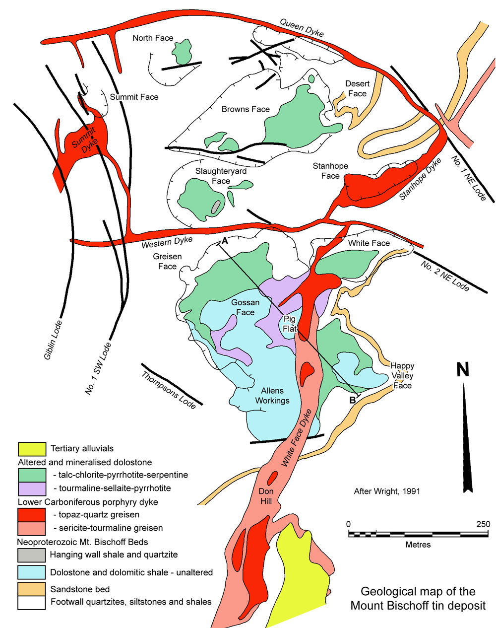
Massive Sulphide Ore - is contained within a single lens that is found at the base of the main carbonate horizon, and ranges in thickness from 0 to a maximum of 30 m, with a discontinuous outcrop strike length of around 450 m. Faulting, folding and erosion has segmented the orebody into a number of ore lenses comprising from north to south; Brown Face, Slaughteryard Face, Greisen Face, Pig Face and Happy Valley Face. Greisen Face, which outcropped over a 200 x 75 m zone, was the largest, while the 70 x 30 m Brown Face was the smallest.
The ore is usually finely laminated, comprising around 50% sulphides, predominantly pyrrhotite with lesser spongy pyrite (after pyrrhotite), minor arsenopyrite and traces of chalcopyrite, sphalerite and stannite. These sulphides are often fine grained and are 'inter-laminated' (as 0.5 to 2 mm laminae) with talc, white sugary quartz, phlogopite, fluorite and coarse grained carbonate. The carbonate is a Ca-Mg-Fe-Mn variety resembling pistomacite, quite distinct from the overlying unmineralised dolomite. In some sections, the pyrrhotite comprises up to 90% of the massive sulphide unit.
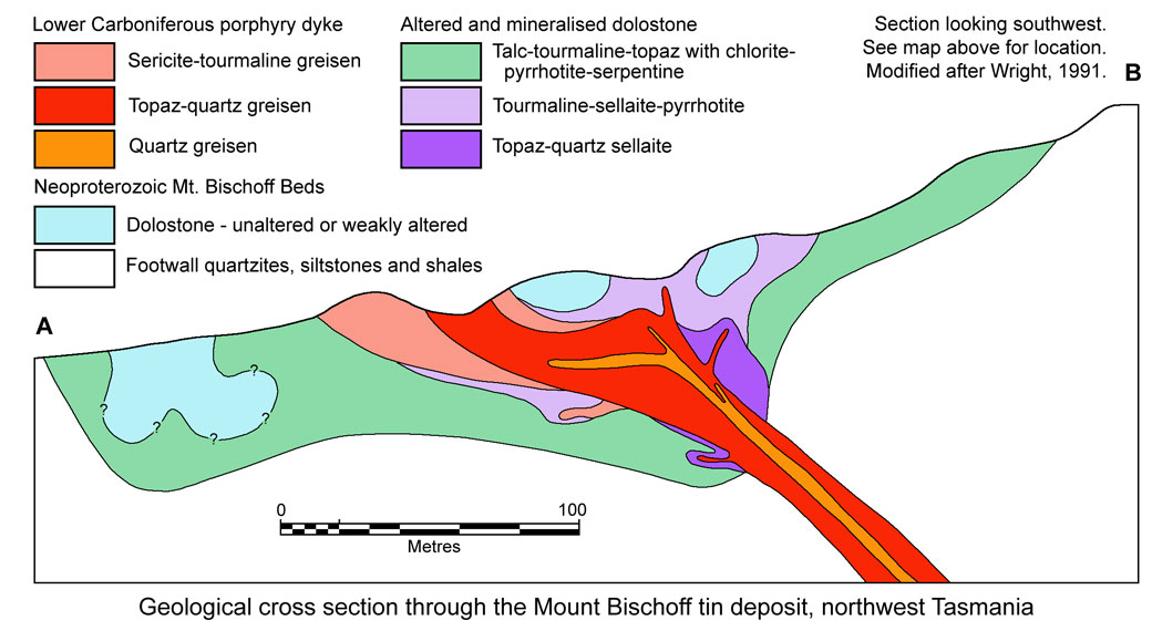
There is a close spatial association between porphyry dykes and the cassiterite-pyrrhotite orebodies in replaced dolostone, with the highest Sn grades occurring close to porphyry contacts (Wright and Kwak,1989). The main development of dolomite replacement sulphide and greisen alteration occurs above a gently dipping section of the White Face dyke, being most intense at the intersection of the margins of the mineralised, altered porphyry dyke, and dolostone above the footwall sediment contact.
Replacement within the dolostone occurred in two separate and distinct stages. During the first, serpentine and chondrodite ((Mg,Fe2+)5(SiO4)2(F,OH)2) assemblages were formed from 460 to 400°C hydrothermal fluids containing 30 to 36 wt.% NaCl. An outward zonation from serpentine to chondrodite to magnesite reflects the lowering of the silica activity in the fluid during reaction with the dolostone (Halley and Walshe, 1991).
This early stage is tin barren, which Halley and Walshe (1991) suggests is because the temperature was too high to allow the fluid to become saturated in cassiterite. They also suggest that of the principal sulphides, only pyrrhotite and arsenopyrite were deposited during this stage.
During the second stage, quartz, talc, phlogopite and carbonate assemblages formed from hydrothermal fluids at 360 to 320°C with about 2 mole/kg NaCl, 1.5 mole/kg CO2 and 0.3 mole/kg CH4. The zonation in these assemblages is from quartz to talc to ferroan-magnesite, which also reflects decreasing silica activity in the fluid. The second stage assemblages extensively overprints the earlier formed mineralogy. Pyrrhotite continues to be the dominant sulphide, which textural studies indicate was formed early in both the first and second stages, and was overprinted by later silicates. Cassiterite was predominantly precipitated within the quartz and talc assemblages during the second stage, when fluid inclusions and textures indicate the fluid was boiling. Loss of H2 in the vapour, combined with wall-rock reactions, is interpreted to have precipitated tin from the fluid (Halley and Walshe, 1991).
The δ18O values of hydrothermal carbonates (16.4 to 19.3‰) indicate that the hydrothermal fluid was isotopically heavy and probably highly exchanged with an 18O_rich sedimentary rock. Sulphur isotope data demonstrate a bimodal distribution with values for the first stage sulphides, ranging between -1.9 to 0.0‰ suggesting a primitive magmatic source, whilst values for the second stage of between 1.5 and 4.5‰ indicate a sedimentary source.
Mineralisation associated with this second stage was formed in two replacement zones, an inner and outer, as recognised by Wright (1991). The inner zone, closest to the quartz-topaz altered dyke, is characterised by a sellaite (MgF2)-topaz-pyrrhotite-cassiterite-quartz assemblage, which only occurs where the altered dyke is in contact with dolostone host. Cassiterite is abundant in the topaz bearing dolostone replacement greisen, with tin grades declining as the outer zone is approached. A narrow transition occurs between the two zones, where topaz and tourmaline coexist (Wright, 1991).
The outer zone is characterised by an assemblage of tourmaline-sellaite-pyrrhotite-fluorite±cassiterite, quartz and hambergite (Be2BO3OH). This outer tourmaline bearing zone is extensively altered to lithium bearing phengite, talc, chlorite, siderite and serpentine, and has a tin content that is lower than the inner topaz bearing zone. Hambergite is concentrated at the outer margin of the outer zone, where tourmaline greisen is in contact with less altered Mg-Fe-Mn carbonate of the host dolostone. It occurs as a coarse rim and vein zone surrounding the outer zone, where it has sharp contacts with fine grained, unaltered dolostone. The outer tourmaline-bearing zone has a finely layered "wrigglite" texture (Askins, 1975; Kwak and Askins, 1981) indicating direct diffusional replacement of dolomite. In contrast, the inner topaz-bearing zone is dominantly massive, with some crudely layered and coxcomb variants, and is interpreted to have formed from the filling of pore space and replacement of "wrigglite" (Wright, 1991).
Sulphide mineralisation is generally more intense towards the base of the mineralised unit. Cassiterite is often low in the more massive pyrrhotite bodies away from the porphyry dykes, usually being closely associated with the talc bands. Sections of the massive sulphide only contain negligible tin (i.e., <0.1% Sn) while the remainder carries from 0.1 to 0.5% Sn, with higher grade kernels of the order of 20 to 30 m in diameter and 5 to 15 m thick assaying from 1 to 3% Sn.
Zones of spongy pyrite and quartz-pyrite ore are found within the massive sulphide unit representing alteration of pyrrhotite rich ore. In places, mineralised pyrrhotite bands were found within the underlying sedimentary rocks of the footwall, a few metres below the main carbonate unit (Halley and Walshe, 1991).
A separate sheeted replacement body occurs at Greisen face, which together with mineralisation at Slaughteryard and Brown face, appear to be related to the east striking Western dyke and a sill of porphyry in the lower portion of the dolostone. The original replacement mineralogy in this body is extensively overprinted by talc, pyrrhotite, siderite and chlorite, although a remnant vertical zoning from topaz to tourmaline style greisen is evident. Tin values are generally higher in the lower levels of this body. Chondrodite (Groves et aI., 1972) and clinohumite are minor phases within this body.
Oxidised and Leached Massive Sulphides - which accounted for the great majority of the historic tin production at Mt. Bischoff. The oxidation and leaching of the massive sulphide orebodies is believed to have taken place during erosional phases between the Late Mesozoic and Recent times. The resultant ore was often present as either a massive friable limonitic gossan or crust, with cassiterite concentrated near the base. In some areas, the Fe and S were completely removed, leaving cassiterite, decomposed talc and fine quartz forming either a boxwork-like structure, or as a clayey sand.
Alluvial and Eluvial Deposits - rich eluvial deposits were formed downslope from the oxidised and leached massive sulphide outcrops. Alluvial accumulations were worked in the Waratah and Arthur Rivers and their tributaries draining the slopes of Mt. Bischoff. The deposits of the Waratah River were in gravels made up of a high proportion of boulders between 30 cm and 2 m in diameter, and yielded some cassiterite nuggets weighing up to 20 kg.
Disseminated Cassiterite within Porphyry Dykes - sections of the dykes at Mt. Bischoff are altered to varieties containing abundant topaz and sulphides with insignificant remaining feldspar. These sections are chiefly found within the vicinity of the massive sulphide body.
The unaltered porphyry, external to the altered and mineralised zone, is composed of phenocrysts of beta quartz (up to 8 mm long), tabular orthoclase (up to 15 mm long), as well as tourmaline and muscovite after biotite. Towards the walls of major dykes, phenocrysts become smaller and less abundant and flow banding is evident (Halley and Walshe, 1991).
Greisen alteration of the dykes is illustrated by that of the White Face dyke, which is zoned from quartz dominant at the centre of the dyke through quartz-topaz and tourmaline-muscovite-(sericite) greisen to sericitised porphyry in an upward and outward progression. The highest tin values are associated with the quartz-topaz zone and more particularly at the 'trailing edge' where topaz was replaced by quartz (Wright, 1991).
During this alteration, micrographic integrowths of quartz and orthoclase initially form overgrowths on the orthoclase phenocrysts, whilst the fine-grained quartz-orthoclase groundmass is generally sericitized. This early stage alteration is potassic, containing about 8% K2O and very little Na or Ca (Halley, 1987; Wright and Kwak, 1989). According to Halley and Walshe (1991), the composition, mineralogy and micrographic textures of the Mount Bischoff porphyries indicate that they crystallised from a water-saturated melt. The potassium-rich composition is considered to be the result of exchange of alkalies between the melt and an exsolved aqueous fluid.
Within the mine area, the porphyries were subsequently altered to pyrrhotite- and cassiterite-bearing greisens, containing from 1 to 10% sulphides, characterised by a hard, white, fine-grained groundmass of quartz and topaz. The porphyritic texture of the rocks was commonly preserved through intergrowths of pyrrhotite, pyrite, quartz, topaz, fluorite and cassiterite that pseudomorph the orthoclase phenocrysts to produce lath shaped masses. Pyrite commonly replaces pyrrhotite, whilst sporadic arsenopyrite and sphalerite, occasionally accompanied by wolframite, and rare stannite are also present (Halley and Walshe, 1991).
Several small sections of these dykes have been mined, principally within close proximity to the massive sulphide orebody. These returned grades of 0.3 to 0.4% Sn. One such dyke worked was the Stanhope dyke which averages 0.2% Sn over a 30 m length 20 m width and 20 m depth. Some of the highest tin grades in the White Face dyke are associated with intense silicic quartz-topaz greisen located in the centre of the dyke, and at the 'trailing edge' where topaz was replaced by quartz. This silicic greisen has a more coarse-grained groundmass of topaz, quartz and fluorite, that has replaced the original fine-grained groundmass, and is characterised by optically continuous overgrowths of quartz on quartz phenocrysts (Halley and Walshe, 1991).
Alteration zonation suggests the dykes were major fluid conduits. The alteration in the White Face dyke is zoned outward from its centre and along the dyke, from silicic to sulphidic to sideritic to sericitic alteration. Coarse-grained mangano-siderite (sideritic greisen) occurs in place of pyrrhotite within the pseudomorphs of orthoclase toward the margins of the greisen, whilst pyrite and some sphalerite locally replaces siderite in the same zone. Beyond the limits of greisenisation, the potassic rocks are variably sericitized. The distribution of alteration within the dykes is indepentent of dolomite and other wall-rocks (Halley and Walshe, 1991).
Vein Deposits - Several cassiterite-bearing polymetallic fissure lodes within the footwall quartzites, siltstones and shales were worked. The genesis of the veins is intimately related to the generation of hydrothermal systems above a granite intrusion. These veins are paragenetically late, and contain quartz and Fe-rich carbonates, accompanied by fluorite, topaz, tourmaline, chlorite, selleite, arsenopyrite, stannite, pyrite, sphalerite, jamesonite and lesser galena and pyrrhotite (Halley and Walshe, 1991). The more significant had the following dimensions and grades:
• Giblin vein, which had a length of 600 m, averaged 0.65 m in thickness and was worked to a depth of 300 m, with an average grade of 1.0% Sn.
• North Valley vein, which had a length of 900 m, averaged 1.30 m in thickness and was worked to a depth of 240 m, with an average grade of 0.8% Sn.
• Queen vein, which had a length of 330 m, averaged 1.00 m in thickness and was worked to a depth of 105 m.
To account for both the geologic and the isotopic constraints Halley and Walshe (1991) proposed that the Mount Bischoff deposit formed as the result of a two-step enrichment-mineralisation process. The first step involved the enrichment of the apical portions of the apophysy of the Meredith Granite below the deposit, with tin, fluorine, boron and other incompatible elements during late-stage fractionation. The second step involved reduced, nonmagmatic fluids entering the solidified granite, mixing with late magmatic fluids, and reacting with the granite, and then altering and extracting tin and fluorine from the enriched zones. These fluids, driven by residual heat in the granite, focused by dykes and related faults, rose through these structures eventually encountering, altering, and mineralising the dolomite by a combination of wall-rock and boiling induced reactions (Halley and Walshe, 1991).
For more detail see the reference(s) listed below.
The most recent source geological information used to prepare this decription was dated: 1995.
Record last updated: 10/12/2015
This description is a summary from published sources, the chief of which are listed below.
© Copyright Porter GeoConsultancy Pty Ltd. Unauthorised copying, reproduction, storage or dissemination prohibited.
Mt Bischoff
|
|
|
Selected References:
|
Halley S W, Walshe J L 1995 - A reexamination of the Mount Bischoff Cassiterite Sulfide Skarn, western Tasmania: in Econ. Geol. v90 pp 1676-1693
|
Knight C L 1975 - Mount Bischoff tin orebody: in Knight C L, (Ed.), 1975 Economic Geology of Australia & Papua New Guinea The AusIMM, Melbourne Mono 5 pp 591-592
|
Knight, C.L., 1953 - Mount Bischoff tin mine: in Geology of Australian Ore Deposits Fifth Empire Mining and Metallurgical Congress, Australia and New Zealand, 1953, The AusIMM, Melbourne v.1, pp. 1185-1193
|
Wright J H 1990 - Mount Bischoff Tin deposit: in Hughes F E (Ed.), 1990 Geology of the Mineral Deposits of Australia & Papua New Guinea The AusIMM, Melbourne Mono 14, v2 pp 1185-1189
|
Wright J H, Kwak T A P 1989 - Tin-bearing greisens of Mount Bischoff, northwestern Tasmania, Australia: in Econ. Geol. v84 pp 551-574
|
|
Porter GeoConsultancy Pty Ltd (PorterGeo) provides access to this database at no charge. It is largely based on scientific papers and reports in the public domain, and was current when the sources consulted were published. While PorterGeo endeavour to ensure the information was accurate at the time of compilation and subsequent updating, PorterGeo, its employees and servants: i). do not warrant, or make any representation regarding the use, or results of the use of the information contained herein as to its correctness, accuracy, currency, or otherwise; and ii). expressly disclaim all liability or responsibility to any person using the information or conclusions contained herein.
|
Top | Search Again | PGC Home | Terms & Conditions
|
|


