|
Shituru |
|
|
Katanga, Dem. Rep. Congo |
| Main commodities:
Cu Co
|
|
 |
|
|
 |
Super Porphyry Cu and Au


|
IOCG Deposits - 70 papers
|
All available as eBOOKS
Remaining HARD COPIES on
sale. No hard copy book more than AUD $44.00 (incl. GST) |
|
|
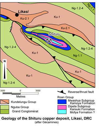
The Shituru sediment hosted copper-cobalt deposit is located near the town of Likasi, 110 km NW of Lubumbashi and 150 km ESE of Kolwezi, in Katanga Province of the Democratic Republic of Congo (DRC). It is in the central part of the ~350 km long Congolese Copperbelt, part of the larger Central African Copperbelt that extends south into Zambia (#Location: 11° 0' 52"S, 26° 45' 50"E).
Shituru has been investigated by drilling and trenching over a period of more than 40 years. Shallow diamond drilling was undertaken in the late 1920s to early 1930s to investigate the lower mineralised zone to depths of about 50 m below surface. The deposit was exploited by open cut from 1919 to 1954, before being abandoned. Historic production during this period is reported as ~445 000 tonnes of copper extracted from ore averaging 10.5% Cu. Gécamines drilled additional diamond holes after 1968 (Simposya et al., 2008).
Regional Setting
For details of the regional setting of the Likasi district, the Central African/Congolese Copper Belt and the Lufilian Arc, see the Congolese Copperbelt record.
Geology
Shituru is one of a number of major to minor copper deposits (e.g., Mutanda, Deziwa, Tilwezembe, Kipoi, Kifumashi and Kasonta) and a series of sub-economic occurrences (<1.0 wt.% Cu) recorded in the Kansuki Formation of the Roan Group, Dipeta Subgroup, within the Congolese Copperbelt.
The Roan Group is part of the Neoproterozoic Katanga Supergroup, and in the DRC, is subdivided into the lowermost R.A.T., Mines, Dipeta and Mwashya Subgroups. These are overlain by the Nguba and Kundelungu groups. For stratigraphic detail see the Congolese Copperbelt record.
The Kansuki Formation has previously been regarded as constituting the Lower Mwashya Subgroup, but has subsequently been included as the upper formation of the Dipeta Subgroup (Cailteux et al., 2007).
The deposit is found on the southwestern limb of a NW-SE trending, north-verging anticline, with a ~55°SW dipping axial plane (Lefebvre, 1974). The limbs of the anticline dip at between 55 and 90°SW. A Roan breccia occurs at the base of the succession and occupies the axial plane of the anticline. It is heterogeneous with multicoloured, rolled fragments and defines a thrust along the main anticlinal axis.
The core of the anticline includes lower to middle Dipeta Subgroup rocks below the host Kansuki Formation, which is, in turn, overlain by the Mwashya Subgroup, and then by the Grand Conglomérat of the Nguba group.
The anticline is sandwiched between two, generally NW-SE trending, but NW-converging, inwardly dipping, reverse faults/thrusts, that placed the Roan-Nguba groups rocks over Kundelungu Group unit Ku-2.1 and underlying rocks, during the Lufilian Orogeny (Cailteux et al., 2007).
The Kansuki Formation commences with a dolostone bed a few metres thick, overlain by a thin (<1 m thick) oolitic band and another ~20 m of dolostone and dolomitic shale (Cailteux et al., 2007; Simposya et al., 2008).
 This is followed by the first of two 3 to 6 m thick volcaniclastic units, "Roches de Kipoi" RK 1 and RK 2, separated by a 12 to 22 m thick band of dolomitic rocks, which is locally marked by massive hematite at the top (Cailteux et al., 2007). These units include:
i). coarse- to fine-grained volcanosedimentary chloritic tuff and lapilli tuff in both bands, containing plagioclase, quartz, phlogopite and tourmaline (Lefebvre, 1973, 1974). This facies is dark grey to black and contains laminated fragments that are flattened and hematite rich, with sinusoidal silica and chlorite rich veins sub-parallel to laminations. The sedimentary strata consist of grey-green, fine grained, weakly silicified argillaceous sandstone.
ii). volcanic breccias, containing clasts from 0.5 to ~50 cm long, occur in the RK 2, indicating eruption of lava flows into or under water.
The upper volcanic unit is followed by ~15 m of interbedded dolostone, shales and dolomitic shale with a thin oolitic bed towards the top.
A number of lithologies have been described as occurring within this succession (after Simposya et al., 2008), including:
* Stratified dolomite, which consists of beige stratified limonitic dolomite, with centimetre scale laminations and white talc rich bands. The talc, which is a replacement of dolomite in tension zones, comprise 15 to over 80% of the rock. Mineralisation is commonly associated with these talc rich bands.
* Dolomitic shales, which consist of green to yellow re-crystallised quartz rich shale with strong chlorite alteration, containing fragments of magnesium-rich basic volcanic rock and quartz rich laminations on a millimetre scale. Another variant is a white to yellow recrystallised dolomitic unit, with 10 to 15% talc, that is weakly mineralised, carbonate rich and occurs mostly at depth.
* Silicified dolostone and dolomitic siltstones, comprising cellular siliceous dolomite and re-crystallised quartz, containing dolomite porphyroblasts that weather and dissolve, leaving cellular siliceous rocks.
* A stratified siliceous rock containing abundant, coarsely recrystallised quartz, typically well mineralised over widths of 5 to 7 m.
The Kansuki Formation is overlain by the ~105 m thick Kamoya Formation of the Mwashya Subgroup at Shituru. Lefebvre (1973, 1974) suggests the Kamoya Formation includes a 1 to 3 m thick siltstone bed containing silicified clasts with black oolites, overlain by a 2 to 4 m thick volcanic breccia, at the base. These basal units are followed by ~11 m of chloritic/tuffaceous sandstones, 54 m of chloritic sandy pelites, interpreted to represent the RK 3 "tuff and lapilli tuff", greenish-grey dolomitic siltites or silty shales containing chert beds, and 36 m of RK 4 chloritic shales or pelites containing conglomeratic beds. The Kamoya Formation is overlain, in turn, by the ~100 m thick black shales of the Kafubu Formation and the thin Kanzadi Formation sandstones that are immediately below the Nguba Group Grand Conglomérat (Cailteux et al., 2007).
Mineralisation
Mineralisation occurs in two main zones (the Lower and Upper) localised within lithologies of the Kansuki Formation, mainly those below the lower volcanic unit (Cailteux et al., 2007; Simposya et al., 2008).
The Lower Zone is hosted by talcose dolomitic rocks, intercalated with shales, while the Upper zone occurs in altered shales and talcose sandstones with lenticular silicified oolite layers.
Historical mining was largely from the Lower Zone, which contained high grades in the supergene interval (averaging 10.5 wt.% Cu and up to 2.0 wt.% Co; François, 1974; Lefebvre, 1974). This zone strikes NW-SE and dips at ~60°S, with a strike length of 800 m and true thickness of ~25 m, persisting down dip for <200 m.
The Upper Zone has a limited strike length of ~500 m, down-dip extent of <200 m and averages ~15 m true thickness, occurring in altered shales and talcose sandstones with lenticular silicified oolite layers.
The two ore zones are generally separated by 25 to 40 m of waste rock, although in detail they are not strictly confined to lithological boundaries and locally coalesce.
Two other localised mineralised zones, the Upper 1 ("U1") and Upper 2 ("U2"), have been intersected in drilling in the hanging wall of the Upper Zone. The U1 occurs at the contact of dolomitic and volcano-sedimentary rocks and is localised within a strike length of ~150 m, with an average true thickness of ~15 m.
Most ores are hosted in dolomitic laminites and dolomitic shales, lithologically similar to the R.S.F./D.Strat. and S.D. rocks of the Mines Subgroup Kamoto and Dolomitic Shales formations, interbedded with sub-economic (<1.0 wt.% Cu) stromatolitic massive dolostone (Lefebvre, 1974).
Mineralisation is predominantly the secondary copper minerals, malachite and chrysocolla, extending to depths of ~80 to 130 m below the surface. At depth, hypogene sulphide mineralisation is of lower grade (0.3 to 2.1 wt.% Cu and 0.05 to 0.1 wt.% Co; Lefebvre, 1974), and consists mainly of bornite, chalcopyrite and chalcocite, which over a transition zone is mixed with malachite and chrysocolla. Native copper and pyrite have also been observed. Cobalt mineralisation, which has been recorded in the eastern and western ends of the deposit is indicative of near surface supergene enrichment. The principal cobalt mineral is heterogenite (Simposya et al., 2008).
There is intense weathering and alteration observed in near surface drill core, with the intensity of the alteration decreasing with depth. Dolomite is decalcified into either a talcose dolomite or a rock consisting primarily of talc (Simposya et al., 2008).
Published production and mineral resource figures include:
Historical production, 1919 to 1954 (Cailteux et al., 2007):
4.2 Mt @ 10.5% Cu for ~445 000 t of Cu.
Historical resource (International Barytex Resources, 2007) as at June 2007:
Lower Zone, indicated resource - 5.22 Mt @ 4.80% Cu Total, 4.33% Cu Acid sol., 0.09% Co Total,
inferred resource - 1.46 Mt @ 2.77% Cu Total, 2.01% Cu Acid sol., 0.04% Co Total.
Upper Zone, indicated resource - 2.66 Mt @ 3.71% Cu Total, 3.33% Cu Acid sol., 0.07% Co Total,
inferred resource - 0.08 Mt @ 3.16% Cu Total, 2.94% Cu Acid sol., 0.07% Co Total.
Upper 1 Zone, inferred resource - 0.53 Mt @ 2.51% Cu Total, 2.13% Cu Acid sol., 0.05% Co Total,
Upper 2 Zone, inferred resource - 0.08 Mt @ 2.77% Cu Total, 2.66% Cu Acid sol., 0.02% Co Total,
TOTAL indicated resource - 7.88 Mt @ 4.43% Cu Total, 3.99% Cu Acid sol., 0.08% Co Total,
inferred resource - 2.15 Mt @ 2.72% Cu Total, 2.09% Cu Acid sol., 0.04% Co Total.
SAMREC compliant mineral resources and ore reserves at 31 August, 2008 (SRK report by Simposya et al., 2008) at a 1% Cu Total cutoff:
measured + indicated low carbonate/talc ore - 5.74 Mt @ 4.38% Cu,
high carbonate ore - 1.80 Mt @ 2.71% Cu.
TOTAL measured + indicated resource - 7.54 Mt @ 4.38% Cu,
inferred low carbonate/talc ore - 0.22 Mt @ 2.51% Cu,
high carbonate ore - 0.01 Mt @ 3.38% Cu,
TOTAL inferred resource - 0.23 Mt @ 2.55% Cu.
TOTAL proved + probable reserve - 7.10 Mt @ 4.30% Cu.
Information in this summary has in part been taken from Simposya et al., 2008, "The Shituru Copper Project, Feasibility Study, Katanga Province, Democratic Republic of Congo"; Technical report prepared by SRK Consulting for International Barytex Resources Limited, October, 2008.
The most recent source geological information used to prepare this decription was dated: 2012.
Record last updated: 10/10/2013
This description is a summary from published sources, the chief of which are listed below.
© Copyright Porter GeoConsultancy Pty Ltd. Unauthorised copying, reproduction, storage or dissemination prohibited.
Shituru
|
|
|
Selected References:
|
Cailteux J L H, Kampunzu A B and Lerouge C, 2007 - The Neoproterozoic Mwashya-Kansuki sedimentary rock succession in the central African Copperbelt, its Cu-Co mineralisation, and regional correlations: in Gondwana Research v.11 pp. 414-431
|
|
Porter GeoConsultancy Pty Ltd (PorterGeo) provides access to this database at no charge. It is largely based on scientific papers and reports in the public domain, and was current when the sources consulted were published. While PorterGeo endeavour to ensure the information was accurate at the time of compilation and subsequent updating, PorterGeo, its employees and servants: i). do not warrant, or make any representation regarding the use, or results of the use of the information contained herein as to its correctness, accuracy, currency, or otherwise; and ii). expressly disclaim all liability or responsibility to any person using the information or conclusions contained herein.
|
Top | Search Again | PGC Home | Terms & Conditions
|
|


