|
Bathurst Mining District - Brunswick #12 and #6, Heath Steele, Halfmile, Caribou, Restigouche, Stratmat, Key Anacon, Austin Brook, Camel Back, Flat Landing Brook, Mount Fronsac, Murray Brook, Orvan Brook, Wedge, Canoe Landing Lake, Nepisguit, Chester |
|
|
New Brunswick, Canada |
| Main commodities:
Zn Pb Cu Ag
|
|
 |
|
|
 |
Super Porphyry Cu and Au


|
IOCG Deposits - 70 papers
|
All available as eBOOKS
Remaining HARD COPIES on
sale. No hard copy book more than AUD $44.00 (incl. GST) |
|
|
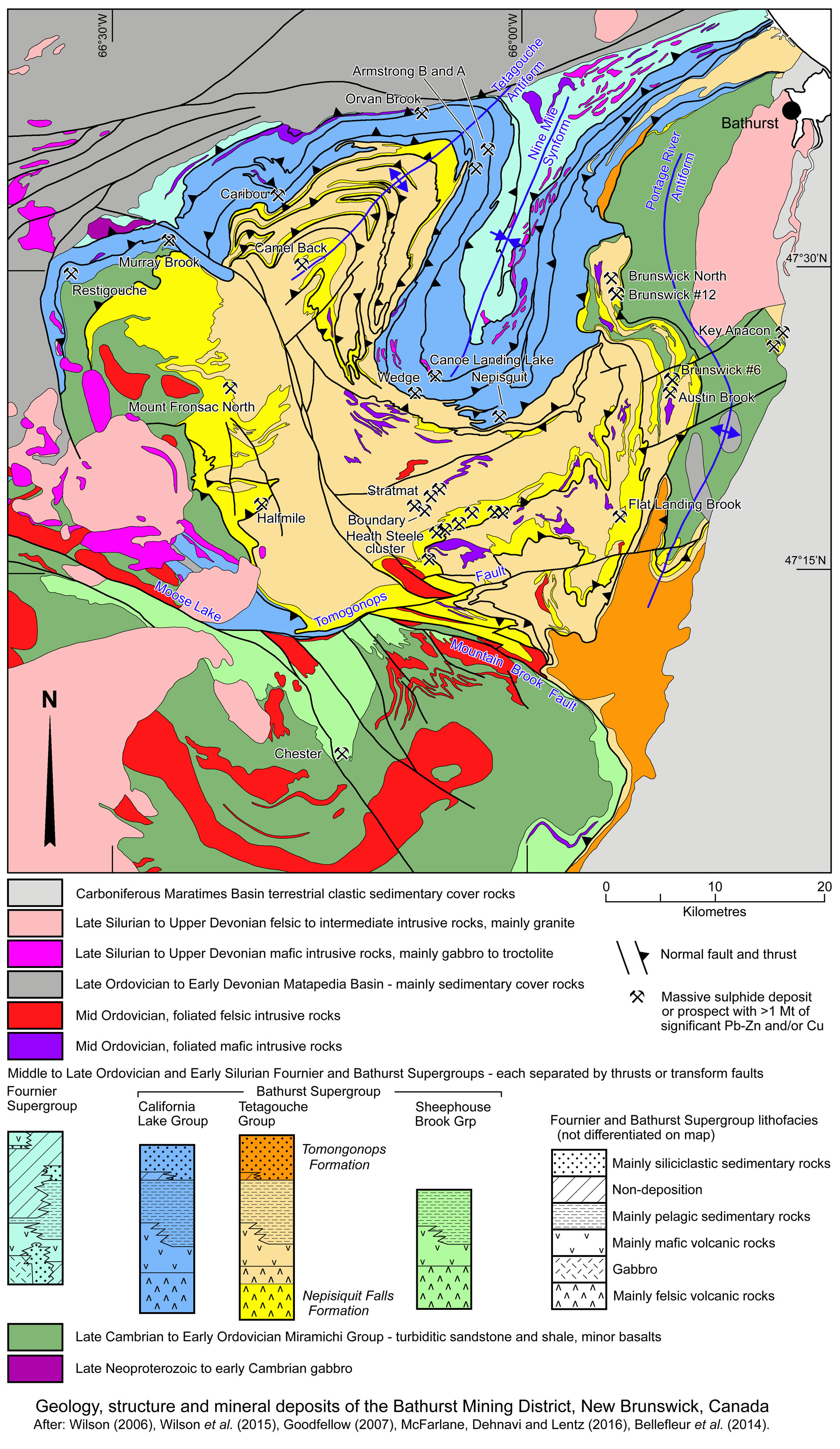
The Bathurst Mining District (or Camp) occupies a roughly circular area of ~70 km diameter, covering an area of ~3800 km2 in the Miramichi Highlands of northern New Brunswick. It includes more than 24 deposits with individual geological 'reserves' exceeding 1.0 Mt of significant Pb+Zn and/or Cu sulphides, included within 46 mineral deposits with 'defined tonnages' and another 100 mineral occurrences. The more significant of these are: Brunswick #12, Brunswick #6 and North End, Austin Brook, Heath Steele, Caribou, Halfmile, Stratmat, Restigouche, Key Anacon, Camel Back, Flat Landing Brook, Mount Fronsac North, Murray Brook, Orvan Brook, Armstrong A and B, Wedge, Canoe Landing Lake, Nepisguit A, B and C and Chester.
(#Location: Brunswick #12 - 47° 28' 23'N, 65° 53' 23"W; Heath Steele - 47° 17' 25'N, 66° 4' 14"W; Caribou - 47° 33' 50"N, 66° 17' 25"W; Key Anacon - 47° 26' 8"N, 65° 41' 52"W).
All of these deposits are plotted on the image below, and a representative selection are described separately below, while the resources and production of most of the more significant deposits are listed at the end of the record.
Interest in the Bathurst Mining District began with the discovery of the Austin Brook hematite-magnetite iron formation in 1897 by a local prospector, William Hussey. Between 1911 and 1913, ~0.16 Mt of iron ore was mined, with a second campaign in 1942 that produced ~0.13 Mt. Whilst the principal target at Austin Brook was for iron ore, the Austin Brook deposit also contains massive pyrite, sphalerite and galena first described by Young (1911), that occurs below the magnetite iron formation. In addition, in 1907, three diamond-drill holes investigating the Austin Brook iron deposit's third zone, located 0.8 km to the north of Austin Brook, intersected the Brunswick #6 deposit, although the sulphide mineralisation was not recognised until late in 1952. In 1951, prior to this recognition, interest in sulphur led to renewed exploration of the Austin Brook area. As part of an evaluation of the district, the potential for base-metal sulphides was realised. Based on the recommendation of this study, the Austin Brook property was optioned in mid-1952 and a diamond drilling program commenced. At the same time, a vertical-loop electromagnetic (EM) survey was also
initiated. Subsequent drilling of strong EM anomalies led to the discovery of the Brunswick #6 sulphide body after the first eleven holes had been drilled in the Austin Brook deposit. The discovery hole was completed in October 1952, and the Brunswick Mining and Smelting Corporation Ltd. was formed within 6 days after. Geological Survey of Canada airborne magnetic contour maps (1951) helped delineate the regional trend of lithological units and resulted in extensive mining titles being taken out over magnetic anomalies in 1952-53. The Brunswick #12 deposit was discovered in the spring of 1953 while drilling a strong electromagnetic anomaly on the Anacon-Leadridge group of claims (MacKenzie 1958). The Brunswick #6 and #12 mines were officially closed in 1983 and at the end of April, 2013 respectively.
The Heath Steele mineralisation was discovered in 1952, shortly after the Brunswick #6 and #12 deposits. It was found by drilling in 1954, following up an airborne electromagnetic (EM) survey anomaly confirmed by ground EM and soil geochemistry. Mining commenced in 1957 but ceased in 1958 due to metallurgical problems and Iow metal prices. Operations resumed in 1962 and lasted until 1983 when low metal prices forced a second shutdown. In this period ore was exploited from the A, B, C and D zones. In 1989 the mill was put back into production to treat ore from the Boundary Zone (straddling the Sttratmat-Heath Steele lease boundary), B and E-Zone. In 1990, a decision was taken to mine the upper part of the C Zone via an existing access ramp to the A Zone. The mine was subsequently closed in 1999 after mining 24 Mt @ 1.8% Pb, 5.2% Zn, 0.93% Cu, 65.6 g/t Ag between 1954 and 1999.
The other deposits and occurrences of the Bathurst Mining District have been progressively discovered or outlined over the last 60 years, some of which are still in production or about to commence mining.
Return to Top
Geological Setting
For a description of the tectonic framework, terranes and geologic history of the northern Appalachian Orogen in eastern Canada, see the Northern Appalachians Overview record (available soon).
The deposits of the Bathurst Mining District occupy a roughly circular area of ~70 km diametre in the Miramichi Highlands of northern New Brunswick. They are principally hosted by the Tetagouche Group and equivalents which comprise the lowest unit of the Middle to Late Ordovician and Lower Silurian Bathurst Supergroup. The host sequences represent a succession of metamorphosed bimodal felsic and basaltic volcanic rocks with intercalated sedimentary rocks deposited within a broad ensialic to to outer ensimatic marine continental margin zone of extension and rifting.
The Tetagouche Group and underlying Miramichi Group was developed over the exotic Gander Terrane and forms part of the Miramichi Massif, a linear tectonic arch in the northern Appalachian Orogen in northeastern US and southeastern Canada.
The rocks in the Bathurst Mining District comprise 5 groups that are largely in tectonic contact with each another (van Staal et al., 2003), as follows:
• The basement upon which the Gander Terrane was built is not exposed, although the oldest known rocks are stromatolite bearing platform carbonates and quartzites in southern New Brunswick and coastal Maine (USA) believed to be ~750 Ma in age, containing detrital zircons as old as 2.7 Ga. Consequently, van Staal et al. (1996) suggest these sequences may be built on Mesoproterozoic and Archaean basement rocks. The Neoproterozoic sequences were followed by an early phase of ~625 to 605 Ma calc-alkaline to tholeiitic magmatism including granite intrusions. These were, in turn, succeeded by a younger, more extensive magmatic phase between ~570 and 525 Ma that accompanied metamorphism and deformation (Nance et al., 2008). Subsequently, two possible magmatic arcs formed on the western margin of the Gander Terrane, i). the 515 to 483 Ma Penobscot Arc composed of include subalkaline, tholeiitic to transitional, basalts to basaltic andesites, picritic tuffs and calc-alkaline to tholeiitic felsic dome complexes; and ii). the ~476 to 453 Ma Popelogan/Victoria arc complex comprising the earlier pulse of felsic to intermediate to mafic calc-alkaline Meductic phase, followed by the 470 to 467 Ma tholeiitic mafic, and rare felsic, calc-alkaline volcanic rocks and overlying shale and chert. These arcs were coeval with the sequences of the Miramichi Group, and the Bathurst and Fournier supergroups overlying the main Gander Terrane, as described below.
• The Late Cambrian to Lower Ordovician, ~500 to 475 Ma, Miramichi Group that represents a thick passive margin marine sequence of unknown thickness, composed of medium to fine grained quartzose to lithic turbidites and shales, but includes some late alkalic and tholeiitic basalts (Wilson, 2006). It has been divided into the Chain of Rocks Formation, a lower unit of thick-bedded quartzose sandstone; the Knights Brook Formation, a middle unit of medium-bedded quartzose sandstone, siltstone and shale; and the Patrick Brook Formation, an upper unit of medium-bedded, feldspathic sandstone and shale (Fyffe et al., 2011).
• The Middle to Late Ordovician and Lower Silurian Bathurst Supergroup is composed of a series of thrust stacked nappes that have imbricated and juxtaposed laterally equivalent intervals of the same succession from across a broad basin during the compressional event involved in the construction of the Brunswick Subduction Complex. The individual nappe plates comprise, from structural bottom to top, the Sheephouse Brook (~466 to 464 Ma), Tetagouche (~467-465 Ma) and California Lake (~472 to 468 Ma) groups. The Sheephouse Brook plate, however, is now separated from its neighbours by a major younger transform structure, the composite Moose Lake-Tomogonops and Mountain Brook fault system. The sequence in each of these plates represents deposition in an extensional regime of continental crustal rifting, and are approximately coeval, with similarities in the internal stratigraphy of each (van Staal et al., 2003). The late Early Ordovician lower sections of each is dominated by felsic volcanic rocks of the 'Meductic phase', overlain by basaltic volcanic rocks that are intercalated with, and overlain by dominantly pelagic medium to fine grained, thin to medium bedded lithic to siliciclastic turbidites, carbonaceous shale and pelagic chert. These are, in turn, overlain from ~450 Ma by dominantly siliciclastic sedimentary rocks. The full section is not represented in all of these structural slices, with varying intervals of the upper and lower sections being absent, truncated by the bounding thrusts. The basalts are both tholeiitic and alkalic, and show a progression from enriched, fractionated continental tholeiites to alkali basalts to the more primitive, mantle-derived mid-ocean ridge, tholeiitic pillow basalts of the structurally overlying Fournier Group (Wilson, 2006; van Staal et al., 1991). The Tetagouche Group is conformably to unconformably capped by a thick succession of siliciclastic turbidites of the Tomogonops Formation which comprise massive to well bedded calcareous quartz-wacke, sandstone, slaty siltstone, and minor thicker-bedded feldspathic and lithic-wacke and conglomerate (Wilson et al., 2015).
The oldest tholeiites are dated at 470 to 467 Ma and correspond to the cessation of the first 476 to 470 Ma calc-alkaline felsic Meductic phase of magmatism which was built on a thick sequence of distinct siliciclastic sedimentary rocks. This was followed by the onset of the calc-alkaline Balmoral phase from 467 to 457 Ma further to the west, and formation of oceanic and mafic-dominated transitional crust (van Staal et al., 2016).
This felsic and mafic magmatism, as mentioned above, can be interpreted to be related to extension, attenuation and thinning of the Gondwana margin prior to the separation of Ganderia. Whitehead and Goodfellow (1978) have interpreted the felsic volcanic rocks low in the sequence, which have been extensively modified by alkali metasomatism, to be products of continental crust that melted during the early stages of rifting of such crust. Similarly, they have demonstrated that the mafic tholeiitic and alkalic basalts of the upper Tetagouche Group are characteristic of basalts formed in extensional environments. As such, this bimodal suite of rhyolites and basalts, and cogenetic granites and gabbros are interpreted to represent rift-related magmatism formed by partial melting of lower crustal rocks and the mantle, rather than a supra-subduction magmatic arc. The attenuation and thinning of the section of the Gondwana margin that separated to become Ganderia, would have meant it was submerged and the site of deep volcano-sedimentary deposition.
Most massive sulphide deposits of the Bathurst Mining District occur in the coeval California Lake, Tetagouche and Sheephouse Brook thrust packages/blocks, and are associated with the respective felsic volcanic rocks in each group. The main massive sulphide bodies in the California Lake Group are represented by the middle to upper Arenig ~472 to 470 Ma Caribou-type deposits, whilst the large Brunswick-type deposits are associated with pyroclastic and tuffaceous sedimentary rocks that occur near or at the top of the ~469 to 468 Ma Nepisiguit Falls Formation of the Tetagouche Group. A few smaller massive sulphide deposits (e.g., Stratmat) are hosted by the overlying ~467 to 465 Ma rhyolites of the Flat Landing Brook Formation. Some contemporaneous massive sulphide mineralisation occurs in the coeval feldspar-porphyritic rhyolites of the Clearwater Stream Formation of the Sheephouse Brook Group, the most significant of which is Chester (van Staal et al., 2003).
The most widely exposed thrust package of the Bathurst Supergroup is the Tetagouche Group. It has been overthrust by the California Lake Group, and is juxtaposed against the Sheephouse Brook Group to the south across the generally WNW-ESE trending Moose Lake-Tomogonops-Mountain Brook transcurrent fault system. The Tetagouche Group has been divided into the following formations from the base (after van Staal et al., 2003): i). Nepisiguit Falls Formation that directly overlies the Miramichi Group, is mainly composed of quartz- and feldspar-phyric felsic volcanic rocks of dacitic to rhyolitic composition; tuffaceous sandstones and shales, and locally some calcareous sedimentary rocks; basalts are absent or very rare. The felsic rocks are known locally as 'quartz-feldspar porphyries', or 'quartz-feldspar augen schists'. Texturally they have mixed pyroclastic and effusive characteristics, grading from clear crystal tuffs to rocks with intrusive-like textures. High strain attenuation and structural repetition impede reasonable estimates of thickness. The felsic volcanic and volcaniclastic rocks have been subdivided into three distinct lithologic units the: Grand Falls Member - relatively coarse grained, quartz-feldspar crystal-rich tuffs, which occur throughout the Bathurst Mining District, but are particularly common in the southern and central areas; Little Falls Member - medium- to fine-grained quartz-feldspar crystal-rich volcaniclastic sandstones; Vallée Lourdes Member - calcarenite and calc-siltite intercalated with minor dark grey, sulphidic, tuffaceous shales, siltstone, and/or sandstone. The Little Falls and Vallée Lourdes members are restricted to the eastern and south-eastern sections of the district; The Lucky Lake Member, typically composed of crystal-poor, fine-grained rhyolitic volcaniclastic rocks, are restricted to the northwestern part of the district. The Grand Falls, Little Falls and Lucky Lake Members has yielded upper Arenig ages between 473 and 468 Ma (U-Pb zircon; Rogers et al., 2003), and are coeval within error, and are consistent with the mid to late Arenig fossils preserved in the Vallée Lourdes Member. Specifically, the Grand Falls Member has been dated at 469±2 and 473±3 Ma (Sullivan and van Staal 1996; Rogers et al., 1997); the Little Falls Member at 471±3 Ma (Sullivan and van Staal, 1996); and the Lucky Lake Member at 468±2 Ma, 469.5±2 Ma and 470±2 Ma (Rogers et al., 2003). A key feature of the Nepisiguit Falls Formation is the Austin Brook Member/Iron Formation which coincides with the 'Brunswick Belt Horizon' along which most of the deposits of the Tetagouche Group are developed. It is essentially a carbonate-oxide-silicate iron formation that varies in composition and texture, both laterally and vertically, and includes iron carbonates (siderite), oxides (magnetite, hematite), sulphides (pyrite, pyrrhotite) and silicates, accompanied by calcite and kutnohorite with chlorite and quartz. It frequently directly overlies massive sulphides within the Nepisiguit Falls Formation, e.g., Brunswick #12, #6, Austin Brook, Heath Steele, and continues along strike from deposits for tens of kilometres. The different members described above are variable developed a across the district and may be dominant or absent in any particular area, as is evident from the deposit descriptions below. ii). Flat Landing Brook Formation, which is best developed in the central part of the district, but pinches out eastward from Brunswick #12. It comprises mainly massive rhyolite flows, either aphyric or sparsely feldspar- (and rarely quartz-) phyric; iii). Little River Formation, comprising transitional to alkalic pillow basalts and flows intercalated with red and green ferro-manganiferous mudstone and chert, and medium to dark grey wacke, siltstone, shale and chert; iv). Tomogonops Formation, a post-volcanic, upward-coarsening sequence of calcareous siltstone, shale, wacke, sandstone and conglomerate deposited over of the Accretionary Prism formations. Rocks within the upper part of the section are markedly less deformed than those near the lower contact.
The California Lake Group which structurally underlies, and occurs in a different nappe than the Tetagouche Group, is considered to be approximately coeval to the latter. It is composed of two main units, the lower of which is known in different locations as the more or less contemporaneous Canoe Landing Lake, Mount Brittain and Spruce Lake formations, which are all conformably overlain by the Boucher Brook Formation.
The Canoe Landing Lake Formation, unlike the apparently coeval Mount Brittain and Spruce Lake formations, which are characterised by felsic volcanic rocks, is composed of alkali basalt, including interflow/intercalated red shale, chert and rare felsic volcanic rocks. The thrust slice made up of the Canoe Landing Lake and overlying Boucher Brook formations structurally overlies the thrust slice consisting of the Spruce Lake and Boucher Brook formations. Three mappable units have been defined within the Canoe Landing Lake Formation, Nine Mile Brook, Orvan Brook and Spruce Lake members. The Nine Mile Brook Member comprises tholeiitic pillow basalt with intercalated alkali basalt, red shale and chert, whilst the Orvan Brook Member is composed of transitional basalts that are between alkalic and tholeiitic in composition. The Spruce Lake Member is a feldspar-phyric, locally amygdaloidal, rhyolite that is lithologically identical to the Spruce Lake Formation, and is interlayered with basalts of the Canoe Landing Lake Formation. Pillow basalts from the Canoe Landing Lake Formation have been radiometrically dated at 472 ± Ma (U-Pb in zircon; Sullivan and van Staal 1993).
The Mount Brittain Formation comprises feldspar crystal-lithic tuff that overlies aphyric to sparsely feldspar-phyric dacitic lava. This formation conformably overlies the Patrick Brook Formation, the uppermost unit of the Miramichi Group, and is overlain by the Boucher Brook Formation. The Charlotte Brook Member of the Mount Brittain Formation is a transitional unit overlying the Patrick Brook Formation and is predominantly a sedimentary sequence of shale and siltstone with local thin tuff beds. A felsic tuff near the top of the formation in the vicinity of the Restigouche deposit has been dated at 468 ±2 Ma (U-Pb zircon; van Staal et al., 2003).
The Spruce Lake Formation, which has been date at ~470 Ma (Walker and McCutcheon 1996; Sullivan and van Staal 1996;
Rogers et al., 1997), is composed of feldspar-phyric felsic lavas, autobrecciated lavas and pyroclastic rocks, including polymictic fragmental rocks and crystal tuff with minor mafic volcanic rocks. It also includes a fine-grained sedimentary unit. Two other units have been differentiated within this formation, namely the Canoe Landing Lake and Shellalah Hill members that are tholeiitic mafic volcanic rocks, and quartz-feldspar-phyric rhyolite and crystal tuff, respectively.
The Boucher Brook Formation is composed of thinly bedded, bluish-grey siltstone and greenish-black shale with minor fine- to medium-grained quartz wacke and minor peralkaline felsic volcanic rocks. The Camel Back Member is abundant in most Boucher Brook sections and is composed of massive and pillowed alkali basalt in the lower part and shale and minor limestone in its upper part.
The Sheephouse Brook Group, comprises, from the base, the: i). Clearwater Stream Formation, that overlies the uppermost unit of the Miramichi Group, the Patrick Brook Formation. It is composed of medium- to dark-green, strongly foliated plagioclase-phyric, dominantly dacitic, volcanic rocks. The schistosity is defined by muscovite and biotite (partially altered to chlorite). Porphyroblasts of carbonate are characteristic of the unit. Structural modification and metamorphism up to biotite grade overprint and generally obliterate primary volcanic structures and textures, although the high abundance of plagioclase crystals and crystal fragments (10 to 45%), as well as local rare bedding suggests pyroclastic emplacement (Wilson and Fyffe, 1996). Local subordinate rhyolites have also mapped in the Clearwater Stream Formation. The contact between the Clearwater Stream Formation with the underlying Patrick Brook Formation has been interpreted to be both highly strained and to be a thrust surface (Wilson and Fyffe, 1996). Volcanic rocks of the Clearwater Stream Formation have been dated at of 469±0.3 Ma, the same age bracket as Nepisiguit Falls Formation volcanic rocks of the Tetagouche Group (Sim, 2014). ii). Sevogle River Formation, which overlies the Clearwater Stream Formation and is composed of massive to well-foliated, light greenish-grey to greyish-pink, K feldspar-phyric rhyolite (Wilson and Fyffe, 1996). Phenocrysts of feldspar vary from 0.2 to 2.0 mm and may comprise as much as 15% of the rock. Local intercalated sedimentary rocks include dark grey siltstones and shales, minor carbonaceous shale and rare lenses of crystalline limestone. Age dating also indicates that the Sevogle River Formation is coeval with the Flat Landing Brook Formation of the Tetagouche Group (465 ±2 Ma). iii). Slacks Lake Formation, which conformably overlies the Sevogle River Formation, and is composed of basalt with interbedded sedimentary rocks and minor comendite a peralkaline type of rhyolite. Sedimentary rocks include dark grey, locally graphitic, shale, and red and green chert. Locally, felsic volcanic and intrusive rocks in both the Clearwater Stream and Sevogle River formations have been found to have chemical similarities suggests a common source for each unit.
• Fournier Supergroup, which structurally overlies the Bathurst Supergroup, and is composed of another three main thrust/nappe slices that are similar in age to those of the Bathurst Supergroup. They are, from structurally lowest to highest, the: i). Sormany Group pillow basalt, progressively overlain by pelagic shales and siliciclastic-rich turbidites; ii). Pointe Verte Group, turbiditic wacke, fine-grained sedimentary rocks and limestone, overlain by high-Cr alkalic pillow basalt; and iii). Devereaux Complex ophiolitic basalts and gabbros. Each group is separated by a thrust and layer of melánge. This supergroup represents more distal facies than those of the Bathurst Supergroup, and straddle the transition between attenuated continental and oceanic crust, characterised by volcanic and intrusive rock of mantle derived MORB oceanic crust forming the ophiolitic Devereaux Complex within the Fournier Group between 465 and 459 Ma. Their deposition was followed by the cessation of calc-alkaline arc magmatism and eruption of transitional and alkalic mafic volcanic rocks between 459 and 455 Ma (van Staal et al., 2016).
The accretion of the leading edge of Ganderia to the composite Laurentian margin in the Caradoc epoch (458 to 448 Ma) of the Late Ordovician was followed by continued convergence. This was accommodated by NW-directed subduction of oceanic crust and the overlying outer Bathurst-Fournier Supergroup sequence beneath Laurentia between ~450 and 430 Ma (van Staal, 1987, 1994). This subduction produced an intensely deformed and tectonically assembled accretionary wedge, the Brunswick Subduction Complex, comprising all of the stacked thrust nappes described above (van Staal, 1994).
The rocks of the Bathurst Mining District have been subjected to complex polyphase deformation and associated greenschist and blueschist metamorphism (Helmstaedt 1973; van Staal et al., 1990). Five episodes of folding have been recognised in the district, but only the first two events account for the majority of the complex structural geometry of the district (van Staal and Williams 1984).
D1, the earliest deformation is characterised by a strong S1 layering-parallel foliation, asymmetric intrafolial folds (F1), and a well-defined stretching lineation (L1). D1 structures are concentrated in zones of high strain, and are commonly associated with stratigraphic repetition. They are interpreted to have resulted from progressive deformation during imbrication in the northwest-dipping Brunswick Subduction Complex (van Staal 1994). The first phase of deformation has been interpreted by van Staal et al. (1992) to have occurred in the Late Ordovician to Early Silurian.
D2, is reflected by tight, near-vertical isoclinal folds of probably Early Silurian age or older (McCutcheon et al., 1993), occurring during continental collision. F2 fold plunges are generally shallow, except when proximal to F1 fold closures. The cleavage associated with F2 folds is well developed, steeply dipping, and sub parallel to S1 along the limbs of F2 folds. This deformation event is partly associated with obduction of the accretionary wedge onto the basin margin.
F3 folds have refolded structures associated with D1 and D2 to form open to tight recumbent F3 folds (van Staal and Fyffe 1991). S1 and S2 fabrics were reoriented to shallow-dipping attitudes where D3 was intense. Earlier structures have been refolded by large- and small-scale F4 and F5 folds, although the overprinting relationships are rarely preserved. The Nine Mile synform and the Tetagouche antiform are examples of later folds (van Staal and Williams 1984). These F4 and F5 structures probably correspond to kink and parasitic folds documented by Davis (1972) in the area of the Caribou Mine.
Three hydrothermal events spanning ~5 m.y. have been recognised, from oldest to youngest, the Caribou, Brunswick and Stratmat horizons. The Brunswick horizon was deposited at 469±2 Ma and hosts both the Brunswick #6 and #12 deposits.
This structural summary is partly after Zhang et al. 2017, NI 43-101 Technical Report by SRK Consulting for Trevali Mining Corporation.
Return to Top
Brunswick #12
The Brunswick #12 deposit is located 30 km SSW of the city of Bathurst in New Brunswick, and was the largest deposit of the Bathurst Mining District. It was discovered in January, 1953 and began production in April, 1964. The mine was owned and operated by Brunswick Mining and Smelting Corporation Ltd, a wholly owned subsidiary of Noranda until a merger with its sister company Falconbridge in June 2005. In mid-2006 the enlarged Falconbridge was acquired by the Swiss-based company, Xstrata, which, in turn, merged with its parent Glencore in 2012-13. The Brunswick #12 mine was officially closed at the end of April, 2013.
The Brunswick #12 deposit is hosted by volcaniclastic rocks that overlie a sequence of felsic volcanic rocks near the base of the Tetagouche Group. The sequence in the immediate Bathurst district that encompasses this deposit is as follows, from the base (after Luff et al., 1992):
Miramichi Group, known locally as the 'older meta-sedimentary' rocks, and comprises a Cambrian to lowermost Ordovician (Lower Tremadacian) metamorphosed grey quartz-phyllite, meta-quartzite and quartzite suite overlain by Tremadacian to Arenginian graphitic slate to dark grey shale unit that contains 1 to 2% pyrrhotite. The observed contact with the overlying felsic volcanic sequence to the east of the Brunswick #12 deposit, as seen underground and in drill core, is highly sheared and graphitic, and may represent a thrust fault.
Tetagouche Group, a sequence of felsic pyroclastic rocks that range from lower to early upper Llanvirnian, comprising:
• a coarse-grained quartz-eye ±feldspar schist that contains quartz, microcline and albite crystals, and 10 to 20% fiamme. Primary igneous textures include micro-perthitic microcline and embayed quartz phenocrysts;
• a finer-grained felsic crystal tuff that is composed of 10 to 30 % relict pumice clasts glass shards. Primary textures also include embayed quartz phenocrysts and fiamme-like structures formed by the collapse of pumice fragment;
• intercalated metasedimentary rocks, mostly consisting of argillite.
All of the vitric components within this part of the volcanic pile have been altered or devitrified to muscovite, quartz and to a lesser degree, chlorite. Textures observed suggest the coarse-grained quartz-eye ±feldspar schist and crystal tuff represent a sequence of felsic pyroclastics with very little sedimentary reworking, apart from the intercalated metasedimentary rocks, although the absence of evidence of rapid uplift since the marine Miramichi Group suggests they were also deposited under subaqueous conditions, with possible contributions from subaerial eruptions in the surrounding district.
• a sequence of volcaniclastic sediments, known as the footwall metasediments, has been metamorphosed/altered to green chloritic and sericitic phyllites. Sulphide layers are found within this facies, increasing in thickness and frequency toward the overlying massive sulphides.
• Massive sulphides - Three major massive sulphide lenses have been recognised at Brunswick #12, distributed in a north-south en echelon array, the West, Main and East Ore zones. A fourth zone has been discovered ~1 km north of the East Ore Zone (Hussey 1992). These massive-sulphide bodies have been divided into three textually, mineralogically, and compositionally distinct units:
- Massive pyrite-pyrrhotite zone, which consists of pyrite with variable, but locally significant pyrrhotite and chalcopyrite, and minor sphalerite and galena, although it grades laterally and vertically into the lead-zinc ore zone. zone. The assemblage pyrite-magnetite is rarely
present in this zone, except in the deeper levels of the mine. It typically exhibits massive to crudely layered, brecciated and veined textures, with layering generally rare and has been interpreted to replace sedimentary sulphides within the host unit. Locally, veins of pyrrhotite crosscut massive pyrite.
- Lead-zinc zone, which comprises massive pyrite interlayered with sphalerite, galena and minor chalcopyrite and pyrrhotite. The latter two sulphides are more abundant below the 850 m level. Due to the high ductility contrast, sphalerite and galena have been remobilised around the more brittle pyrite to give the rock a 'flow-layered' texture.
- Massive pyrite zone, which consists of fine-grained pyrite, with minor sphalerite, galena and chalcopyrite. The pyrite is massive to weakly banded, and locally has collomorphic textures.
• Carbonate-magnetite-silicate iron-formation, composed of siderite, calcite and kutnohorite [CaMn2+(CO3)
2] with silicate minerals chlorite and quartz. Magnetite, which is a metamorphic decomposition/alteration product after siderite, and is the predominant iron oxide mineral. The iron-formation also contains minor apatite, spessartine garnet, grunerite, pyrrhotite and variable pyrite, sphalerite and galena. The only primary minerals which survived the metamorphism/alteration are siderite and apatite. The iron-formation is interbanded with sulphides near its basal contact and is infolded with the sulphides, particularly at the north end of the sulphide lenses.
• Hanging wall metasediments and felsic tuffs - grey chloritic- and muscovite-phyllitic sedimentary rocks with intercalated aphyric rhyolite and lapilli tuff.
• Alkali basalt and maroon chert - a thick sequence of late Llanvirnian to Cardocian, mostly pillowed alkali basalts with magnetite-rich portions.
• Late intrusions - feldspar-phyric dykes and tholeiitic gabbro.
The geometry, grade and thickness of the Brunswick deposits have been heavily influenced by structure, with the ore being attenuated on the limbs of, and concentrated in the axial zone of, isoclinal F1 sheath folds where they are intersected by tight F2 folds. The ore and iron formation predates the oldest folding, although it is regarded that the attainment of ore grade and economic thickness is a result of the structural modification.
The longitudinal projection of the Main Ore Zone in the plane of the F2 fold axis has the form of a generally broad 'V' shape that has been rotated 45° in a clockwise direction. This projected shape has a strike length of ~1500 m and down dip extent of ~1250 m. The trace of the F1 fold axis follows the 'V' shape of the ore zone projection. The Main Ore Zone is composed of two parallel sulphide lenses on opposite limbs of a tight F2 fold. The East and West Zones do not outcrop and occur to the east and west of the Main Zone respectively on the limbs of further F2 folds that have folded these zones into two lenses each. The Main Zone therefore appears to represent the limb of a major F1 fold that has been folded by F2. At greater depth, the Main, West and East ore zones converge where F2 folds formed near an F1 hinge. At still greater depths, the massive-sulphide zones bottom out as the nose of the F1 fold is approached.
On a regional scale in the Bathurst district, thrusting has been shown (van Staal, 1987) to accompany the D1 deformation and may account for some of the thrusting of the Brunswick #12 deposit. F2 folds are tight asymmetric to isoclinal and overturned to the east. The intersection of F1 and F2 folds is important from a mining viewpoint, as this causes structural thickening of the massive sulphides (van Staal and Williams, 1984).
F3 folds are open to tight, with steep axial planes trending NE to east, whereas F4 and Fs folds comprise two groups of kink bands. These three phases of deformation have had little effect on the distribution of sulphides except for local open folding of the sulphide lenses.
Estimated Reserves + production at Brunswick #12 and #6 amount to (in 1998):
161 Mt @ 8.83% Zn, 3.55% Pb, 0.31%, Cu, 99 g/t Ag, plus 25 Mt @ 1.1% Cu.
In addition the deposit contains 166 Mt of low-grade massive pyrite.
Total production between 1964 and 2013 - 137 Mt @ 8.74% Zn, 3.44% Pb, 0.37% Cu, 102 g/t Ag (various sources).
Return to Top
Brunswick #6
The Brunswick #6 Zn-Pb-Cu-Ag massive sulphide deposit is located ~10 km SE of Brunswick #12. The oldest rocks in the vicinity of the deposit are metamorphosed shale and quartzite of the Knights Brook Formation of the Miramichi Group. This unit is poorly exposed near Brunswick #6, but generally comprises thinly bedded graphitic shale to carbonaceous shale and medium- to thick-bedded, quartz-rich wacke. The deposit lies between two subaqueous felsic volcanic formations near the base of the Middle Ordovician Tetagouche Group. The footwall sequence is composed of rhyodacitic pyroclastic rocks of the Nepisiguit Falls Formation, the basal unit in the Tetagouche Group, which conformably to disconformably, and relatively sharply overlies the Knights Brook Formation. It is composed of, in ascending stratigraphic order (after Lentz and MacCutcheon, 2006):
• Medium- to coarse-grained crystal tuff, referred to elsewhere as 'porphyry' (Lea and Rancourt, 1958; Pearce, 1963), 'augen schist' (Boyle and Davies, 1964; Davies, 1972; Rutledge, 1972; Luff, 1980), or the 'lower felsic metapyroclastic subunit' (Nelson, 1983). They are rhyodacitic tuffs that are relatively homogeneous with a cryptocrystalline groundmass and typically contain 5 to 15% phenocrysts of subhedral to euhedral K feldspar and quartz crystals that range from 3 to 18 mm in size, set within a homogeneous, very fine grained vitreous matrix. This massive crystal tuff cmprises the lower part of the Nepisiguit Falls Formation and is considered to be a tuff-lava (welded ash flow) rather than an intrusive porphyry. Coarse- to medium-grained quartz-feldspar crystal tuff/tuffite is intercalated and crossbedded with fine-grained tuffaceous sedimentary rocks, which generally overlie the massive crystal tuff, and contain up to 50% rounded crystals with locally magmatically broken crystal shards and possibly relict pumice fragments that are locally preserved.
• Fine- to medium-grained crystal tuff/tuffite, also referred to as 'sheared porphyry' and 'augen schist' (Pearce, 1963; Boyle and Davies, 1964; Davies, 1972; Rutledge, 1972; Luff, 1980), although Nelson (1983) referred to it as the 'upper felsic metapyroclastic subunit'. It is a texturally inhomogeneous unit and constitutes the bulk of the Nepisiguit Falls Formation in the deposit area. It generally contains 10 to 25% phenoclasts as crystal slivers and rounded grains of feldspar and quartz, which vary from 0.3 to 3.0 mm in size, set in a granular fine-grained matrix. Lenses and discontinuous beds of phenoclast-free ash tuff are intercalated with the unit and are locally abundant, particularly towards the top of the formation. The unit has characteristics consistent with explosive eruption, but low-temperature deposition involving sorting and winnowing. Feldspar-destructive alteration is common in the deposit area, giving rise to the 'quartz augen schist' texture (Lentz and Goodfellow, 1993).
• Tuffaceous mudstone, which is typically well foliated, has also been historically named the 'footwall metasediments' (Luff, 1980) and 'quartz-chlorite schist' (Nelson, 1983), is spatially associated with the overlying massive sulphides and iron formation. It lacks phenoclasts typical of the underlying tuff/tuffite unit, has invariably been subjected to chloritic alteration, and commonly contains sulphide veins. It is interpreted to be either a mixture of ash tuff and hydrothermal chemical sediment that accumulated in a local topographic sea floor depression (Lentz, 1999a), or an intense hydrothermal
alteration product of the tuff/tuffite unit adjacent to the massive sulphides.
• The Brunswick horizon - the stratigraphic position at which massive sulphides occur in a number of deposits in the Bathurst Mining District, including Brunswick #12 and #6. At both of these deposits, massive sulphides are capped by, and are laterally gradational into, iron formation.
The massive sulphides at Brunswick #6 have been divided into three compositional zones (Luff, 1980; MacLellan et al., 2006), which are, in ascending order stratigraphically:
i). a copper-rich pyrite-pyrrhotite zone, with minor sphalerite and galena, and minor to significant amounts of chalcopyrite and magnetite;
ii). a a massive pyrite zone composed of very fine grained pyrite with minor sphalerite, galena and chalcopyrite; and
iii). a lead-zinc zone comprising banded pyrite-sphalerite-galena, with minor chalcopyrite and pyrrhotite.
Minor arsenopyrite and tetrahedrite are disseminated throughout the massive sulphides. The basal copper-rich pyrite-pyrrhotite zone occurs as a keel (sheath) formed by a F1-F2 interference pattern extending from the base to the north end of the deposit, with the transposed stockwork stringer zone that cores the footwall alteration system extending at depth beneath the deposit, and to the north into the footwall.
All of the sulphides have been annealed to some degree, but fine-scale layering of the sulphides is still evident, accentuated by mineral content differences. This layering may be in part primary, where preserved in massive, pyrite-rich zones that have behaved more competently than the other sulphide zones. However, layering within the main lead-zinc ore zone has been modified by deformation (van Staal and Williams, 1984). The principal sulphide assemblage in the lead-zinc zone includes boulangerite, bournonite, enargite, cassiterite, stannite, marcasite, tennantite, freibergite, rare native bismuth and bismuthinite, and native gold have also been described from the primary ore types of the Brunswick deposits (Lea and Rancourt, 1958; Stanton, 1959; Aletan, 1960; Boorman, 1975; Petruk and Schnarr, 1981).
There is spatial association of ticker footwall sedimentary rock with the massive sulphide lenses, which together with an abrupt termination of massive sulphides laterally, has been interpreted to indicate the massive sulphides accumulated in a small basin that may have been fault bounded. The continuity of magnetite-chert iron formation away from massive sulphide accumulations has been taken to suggest a regional dispersion and saturation process occurring in a stable basin (Lentz and MacCutcheon, 2006).
• Iron formation - as at Brunswick #12, the massive sulphides are capped by, and are laterally gradational into, iron formation. At Brunswick #6, the massive sulphides are immediately overlain by a thick unit of thinly layered chert-magnetite iron formation that is generally devoid of sulphides. The top of the iron formation defines the upper limit of the Nepisiguit Falls Formation along the Brunswick Belt (van Staal et al., 1992) as it marks a major change in the type of volcanism, and is an easily recognisable, regionally extensive, marker horizon.
The hanging wall is occupied by the Flat Landing Brook Formation, which is <3 m.y. younger than the footwall Nepisiguit Falls Formation. It is predominantly composed of black to grey reddish, massive, aphyric to sparsely feldspar-phyric (10% crystals) rhyolite and breccia with minor hyalo-tuff and sedimentary rocks. The rhyolites locally contain up to 5% quartz amygdules, and form domes with fragmental rhyolite (breccia) and hyalotuffaceous sedimentary aprons (McCutcheon, 1992; Lentz, 1999). Local, thin exhalite units occur in some of the interflow sedimentary rocks.
The overlying Little River Formation, consists of pillowed alkali basalts (van Staal, 1987; van Staal et al., 1991) and an interbedded, thin, laterally continuous, black, red, or green Fe/Mn-rich shale, siltstone, or chert sequence. The magnetite-bearing pillow basalts and hydrothermally altered, spilitised alkali basalts (Whitehead and Goodfellow, 1978; Saif, 1983; van Staal, 1987), which have a very pronounced magnetic expression, are sometimes referred to as 'basic iron formation' because of the high abundance of magnetite, chlorite, epidote, albite, actinolite, carbonate, quartz and minor pyrite. The hanging-wall rocks at Brunswick #6 mine are intruded by a southwesterly plunging body of tholeiitic metagabbro (van Staal, 1987; Paktunc, 1990) that are not the subvolcanic intrusive equivalents of the Little River basalts because the latter are Fe-Ti alkalic tholeiites (Lentz and MacCutcheon, 2006).
Hydrothermal alteration in the footwall is much more extensive over intervals of up to a few hundred metres, both vertically and laterally, compared to the hanging wall where it is generally <100 m. Other weaker alteration and base metal anomalies farther up in the hanging wall sequence appear to be associated with independent alteration systems related to the hanging wall rhyolite domes. The least-altered footwall units, farthest from the massive sulphide, have undergone albite or adularia alteration with weak Mg enrichment (as chlorite). This type of alteration is developed regionally in both the hanging-wall and footwall felsic volcanic rocks (Lentz, 1999). The proportion of dark green, Fe-rich chlorite in the footwall increases with proximity to the deposit forming at the expense of feldspar and sericite, such that K concentrations decrease toward the deposit. Stockwork sulphidic veins that typically range from several cm to tens of metres in width, increase in density with increasing Fe-chlorite alteration and are intimately associated with the silicified zone which occurs at the base of the massive sulphides forming an upward margin to the chloritic zone. However, some stockwork sulphidic veins also occur within intensely sericitized rocks. The transposed stockwork sulphide stringers are typically composed of Fe-rich chlorite (±sericite, ±silica) with pyrite, pyrrhotite, chalcopyrite, arsenopyrite and sphalerite. Alteration transgresses stratigraphy and is most intense 10 to 25 m below the massive sulphides east of the deposit (Lentz and MacCutcheon, 2006).
The deformation and geometries of the Brunswick #6 and #12 deposits are essentially the same. The host rocks and sulphides at both occur within tight F1 and F2 folds that have well-developed axial planar foliations (S1 and S2). The sequence is mostly upright and dips at ~60°W in the vicinity of the deposit. The composite S1-S2 foliation dips at ~80°W, with parasitic F2 folds dominating the local fold structures. The S1 cleavage has been folded by mesoscopic F2 folds with a pronounced axial S2 planar fabric (van Staal and Williams, 1984; Lentz, 1999). Both deposits occur in large asymmetric F2 fold hinges that have a marked variation in plunge due to the influence of the earlier F1 fold closures. At Brunwick #6, the main F1 structure is a large overturned F1 fold that has been deformed by F2 to form interference folds. Many other primary features, such as the interpreted stringer sulphide zone and associated alteration, are transposed by deformation and later alteration, with most of the footwall sulphide stringers being parallel to S1 and S2. The degree of S1 and S2 fabric development is a function of the intensity of hydrothermal alteration which produced a high mica content in altered pyroclastic rocks making them more susceptible to strain localisation (Lentz and MacCutcheon, 2006).
Brunswick #6 was mined between 1966 and 1983 and produced 12.125 Mt @ 5.43% Zn, 2.16% Pb, 0.39% Cu, 67.0 g/t Ag (Luff et al., 1993)
Return to Top
Austin Brook
The Austin Brook Iron Mine is located ~800 m south of the Brunswick #6 deposit. The history of discovery is detailed at the beginning of this record in the segment on the history of the Bathurst Mining District. The Austin Brook Mine was originally known as Drummond Mines, and produced ~0.145 Mt of iron ore between 1911 and 1913, when Canada Iron Corporation closed the mine (Belland 1992). The mine was reopened in 1943 to feed the Dominion Steel and Coal Company (DOSCO) operations in Nova Scotia after its sea-borne supply from Newfoundland came under threat during World War II. DOSCO mined ~0.118 Mt of ore from Austin Brook before closing it at the end of 1943.
Austin Brook lies within the Tetagouche Group in the same stratigraphic and structural setting as Brunswick #6, described above, but is principally a magnetite-hematite deposit, although it also has a less well developed thin massive sulphide lens located immediately beneath the iron formation. In contrast to Brunswick #6, where massive sulphides are immediately overlain by a thick unit of thinly layered chert-magnetite iron formation that is generally devoid of sulphides, at Austin Brook, the hematite content of the iron formation increases at the expense of magnetite, mainly along foliation planes. The Austin Brook Iron Formation is also known as the Brunswick Horizon which overlies many of the massive sulphide deposits of the Nepisiguit Falls Formation as described above.
A traverse across the Austin Brook mine sequence from the footwall, is described as follows in McCutcheon et al. (2005):
• Very fine grained, footwall pyritic and sericitic sedimentary rocks of the Nepisiguit Falls Formation. The quantity of chlorite and disseminated
sulphides increase towards the contact with the massive sulphides and iron formation, which dip steeply to the west. These sericitic-chloritic phyllites contain anomalous amounts of silica, apatite and Fe-rich chlorite;
• Massive-sulphide layer, which is coarse-grained and pyrite-rich, with minor sphalerite. This layer is located above altered footwall sedimentary rocks as described above, and beneath the iron formation;
• Hematite-magnetite iron formation, which is a complexly folded, thinly layered, hematite-magnetite rock, composed of well developed
compositional layering that is defined by alternating competent jasper and magnetite and incompetent hematite laminae. In addition to magnetite, this iron formation also contains chlorite, chert, siderite, specularite and jasper. The complex folds are coplanar to F1 and F2 folds developed in the surrounding volcanic rocks and also have the same style and plunge directions. Quartz in jasper layers and intrafolial folded quartz veins show evidence of intracrystalline deformation and grain boundary adjustment and have a c-axis fabric related to the folding. Hematite is strongly foliated, kinked or bent in the hinges of the F1 and F2 folds, indicating intracrystalline deformation. Folds are much better developed within the iron formation, compared to the surrounding rocks. The steeply dipping iron formation appears to be exposed over a width of ~100 m.
See the Brunswick #12 and #6 records for descriptions of the iron formation at those locations.
The massive sulphides at Austin Brook are estimated to comprise: 0.2346 Mt @ 3.67% Pb, 5.68% Zn, 0.09% Cu, 82 g/t Ag; plus 3.022 Mt of pyrite (McCutcheon, Luff and Boyle, 2003).
Return to Top
Heath Steele
Heath Steele string of deposits is distributed over a strike length of ~12 km and is located 65 km SW of Bathurst, 20 km SW of Brunswick #12 and 51 km NW of Newcastle. The deposits were discovered as the result of one the earliest airborne electromagnetic (EM) surveys flown, conducted for the American Metal Company in 1954. Numerous anomalies were returned, and the second follow-up drill hole intersected the Heath Steele A-Zone, initially known as Little River, but later re-named. Subsequent drilling of other airborne EM anomalies led to the discovery of the B, C, D, and E zones.
Heath Steele is the second largest Zn-Pb-Cu-Ag massive sulphide operation in the Bathurst Mining District. It occurs as a number of massive sulphide deposits of varying sizes hosted by a thick, north-younging, sequence of interbedded greenish-grey to dark-grey laminated mudstone, siltstone and fine- to medium-grained volcaniclastic rocks which are generally chloritic. The volcaniclastic rocks are interpretted to comprise a mixture of epiclastic and lesser exhalative components. These rocks are within the upper part of the Nepsiguit Falls Formation which forms the basal section of the Middle Ordovician Tetagouche Group. The Tetagouche Group was intruded by granite and gabbro masses at the onset of regional, low-grade greenschist metamorphism.
The presence of common F1 sheath folds and the amount of porphyroclast extension within the host rocks indicate that the deposits of the Heath Steele mines were subjected to higher D1 bulk strain than the deposits in the Brunswick mines (i.e., Brunswick #12 and #6) area, consistent with the former deposits being located within, and in the immediate hanging wall, of the major, ductile Heath Steele Shear/Thrust Zone (the major thrust shown to the south of the Heath Steele deposits on the attached image).
The 5 main deposits at Heath Steele, named A to E zones inclusive, are hosted by crystal rich felsic volcaniclastic rocks and associated tuffaceous sediments of the Nepisiguit Falls Formation. The sedimentary rocks and intercalated felsic tuffs hosting these deposits, and the associated hydrothermal sedimentary rocks which include iron-formation and chlorite tuff, have a strike length of at least 12 km and can be traced westward from the B5, to the B, A-C-D zone, and on to the West Grid/HC4 zone, around the North Little River Lake fold (with a NW-SE fold axis), and then south to the Satellite zone on the western end of the cluster. A second stratigraphic unit which hosts the H2 and Mowat zones on the west limb of the North Little River Lake fold has a strike length of at least 4 km. The Boundary deposit is located to the north, straddling the boundary between Heath Steele and Stratmat, while the N-5 Zone is a fault offset of the same deposit, but within the Heath Steele lease.
The immediate sequence hosting the Heath Steel deposits dips steeply to the north above a SSE vergent sole thrust, the Heath Steele Shear Zone, that places it over younger Flat Landing Brook Formation volcano-sedimentary rocks that are also found at the top of the same sequence. The succession, from the sole thrust upwards, is as follows (after de Roo et al., 1991; Hamilton et al., 1993; Peter and Goodfellow, 2003):
• Metasedimentary rocks of the Nepisiguit Falls Formation - mica-rich pelites, semi-pelites and chloritic felsic volcani-clastic tuffaceous rocks with a mesoscopic layering, characterised by rusty weathering and abundant veins. They are characteristically relatively homogeneous with phyllitic to schistose textures and rare to absent retained primary sedimentary structures due to the intense deformation. They comprise mineral assemblages mainly of chlorite, quartz, mica and accessory heavy minerals, and enclose minor interbedded felsic volcaniclastic rocks containing volcanic quartz crystals (augen). Lentz et al. (1997) have geochemically differentiated upper and lower footwall sedimentary rocks into the Nepisiguit Falls Formation and the Miramichi Group respectively (Peter and Goodfellow, 2003);
• Augen schists or felsic volcanics of the Nepisiguit Falls Formation - The metasedimentary rocks described above are juxtaposed, or intercalated, with quartz augen schists and quartz-feldspar augen schists. Whilst most augen are quartz and feldspar porphyroclasts, lithic augen are also present. There is a local crude layering that is laterally discontinuous, defined by variations of phyllosilicates and/or augen size and abundance in the matrix. Intercalations of pelite vary from isolated layers, up to as much as 50 vol.% of the rock volume. These schists are derived from protoliths that include felsic volcanics, volcaniclastics and shallow intrusions (van Staal, 1987). They have been subdivided into (Peter and Goodfellow, 2003):
- Footwall crystal tuffs which contain up to ~30 vol.% reworked crystals of quartz and lesser relict microcline and albite that are up to 5 mm in diameter set in a light to dark grey, siliceous matrix. Locally, as in the B zone, these tuffs directly underlie massive sulphides. They are interpreted to be of volcanic origin on the basis of the embayed nature of some feldspar phenocrysts, as well as the presence of broken quartz and feldspar crystals.
- Hanging wall crystal tuffs, also referred to as quartz-feldspar porphyry, occur in the immediate structural and stratigraphic hanging wall to the massive sulphides and iron formation described below. They are characterised by up to 35 vol.% quartz and K feldspar phenocrysts and varying amounts of felsic lithic clasts, which with the phenocrysts, define a crude banding. However, in the immediate proximity of massive sulphides, feldspars are conspicuously absent, presumably due to hydrothermal alteration;
• Meta-porphyry and meta-granitoid masses are concentrated several kilometres the southwest of the North Little River Lake fold axis and the main Heath Steele deposit cluster, interfingering with and intruding the metasedimentary rocks of the Nepisiguit Falls Formation. The metaporphyry has a massive texture and is considered to be a less deformed/altered equivalent of the quartz augen schist. It grades laterally into rocks with a semi-porphyritic coarse crystalline texture that have been interpreted to be part of a pre-tectonic suite of 480 Ma (Rb/Sr; Fyffe et al., 1977) metagranitoids. The latter are devoid of a contact aureole and are surrounded by compositionally similar meta-volcanic and meta-sedimentary rocks, suggesting a shallow volcano-sedimentary regime (Fyffe et al., 1977, 1981; van Staal, 1987; de Roo et al., 1991).
• Felsic phyllites and meta-rhyolite of the Flat Landing Brook Formation - which, both stratigraphically overlie and structurally underlie the units above. These rocks form a major part of the regional sequence, occurring as felsic phyllite, massive meta-rhyolite with spherulitic or amygdaloidal textures, meta-agglomerates and banded cherts. Some phyllites contain felsic lithic augen and porphyroblasts, but are differentiated from the augens schists by the small size and lesser abundance of the augen, interpreted to reflect a lower strain field;
• Mafic metavolcanic rocks - which form a discontinuous, up to 100 m thick band within the Flat Landing Brook Formation several hundred metres above its base. These rocks have been metamorphosed to greenschists, although relict pillows or hyaloclastic textures are still recognisable;
• Meta-dolerite. The mafic metavolcanic rocks grade laterally into subophitic meta-dolerite of limited lateral extent, although larger masses of similar intrusives are evident in the lower plate Flat Landing Brook Formation to the south.
• Base metal sulphides of the deposits within the Nepisiguit Falls Formation predominantly occur as stratabound accumulations of pyrite, galena, sphalerite, chalcopyrite and pyrrhotite. Three styles of sulphide occurrence are recognised within these deposits, namely:
- Massive pyrite-pyrrhotite, which are generally fine-grained and commonly also contain bands of chlorite, quartz and magnetite as well as thin discontinuous layers or lenses of sphalerite and galena.
- Banded sulphide - which represents the bulk of the ore. It comprises alternating bands of pyrite, sphalerite and galena, but less frequently with chalcopyrite and pyrrhotite, accompanied by aggregates of chlorite, quartz and host rock that are interlayered with the massive sulphides or with disseminations of granoblastic pyrite. This assemblage is accompanied by minor magnetite, arsenopyrite, tetrahedrite-tennantite, cosalite, boulangerite and complex Pb-Bi-Sb-Ag sulphosalts. Sphalerite grains contain inclusions of chalcopyrite, pyrite and stannite (Hamilton et al., 1993).
- Fragmental or breccia sulphide - which are copper rich and characteristically comprise sheetlike bodies defined by clasts of various compositions set in a chalcopyrite-bearing, pyrrhotite dominated, sulphide matrix. It mainly occurs along the footwall of the B and the combined ACD zones, although it also locally cuts across the sulphide body and zoning pattern when folded by F2. Elsewhere it appears to both overlie and underlie the banded lead-zinc ore. Clasts include wall-rock fragments, single crystals or aggregates of pyrite, layered sulphides, and mineral inclusions (Owsiacki and McAllister, 1979). Clasts of pyrite vary from massive, to textureless, to granoblastic or framboidal textures, including foliated aggregates with interstitial sulphides, silicates and/or carbonates. Associated mineral inclusions comprise idioblastic or cataclastically deformed pyrite, poikiloblastic magnetite, silicate and/or carbonate minerals. Clasts vary from <<1 to ~500 mm and are angular or rounded and locally indented or embayed by matrix sulphides. The matrix sulphides commonly exhibit a distinct but generally not strongly developed S1 foliation and L1 lineation defined by individual pyrrhotite and chalcopyrite grains, elongate aggregates of pyrite, sphalerite and wall-rock clasts, boudinaged minerals and strain shadows. Most of these fragmental sulphide zones are also folded or crenulated by F2. In addition de Roo and van Stall (2003) note that i). the wall-rock clasts contain tectonic structures, e.g., fibrous quartz veins, and probable S1 folds and a foliations (McDonald 1983); ii). fragmental sulphide zones cross-cut the gross metal zonation and ore zones at a low angle; iii). the breccia zones appear to be devoid of macroscopic scale F1 folding, but have been folded by F2; iv). the bulk of the wall-rock clasts are angular and embayed; and v). in places the clasts define a jigsaw breccia. Based on these observations, these authors concluded that the Heath Steele sheet-like fragmental sulphides zones resulted from localised brecciation and fluid-assisted dissolution and infilling of sulphides during the late stages of D1. Brecciation most likely involved clast rotation and cataclastic deformation of pyrite. The generally weak development or absence of S1 in the breccia matrix compared to the strong development in the banded sulphides suggests that remobilisation (or late stage introduction) of pyrrhotite and chalcopyrite into the breccia was dominantly the result of their introduction in solution and replacement of existing sulphides, or deposition in fractures, during D1.
The entire assemblage is cut by pyrrhotite-chalcopyrite, barren quartz and quartz-chalcopyrite veins. These veins exhibit varying states of deformation from boudinaged sheets parallel to S2, to discordant veins that crosscut S2, as well as en echelon vein arrays that are also common. (Hamilton et al., 1993).
The massive sulphide mineralisation has generally accommodated more strain than the wall rocks, as indicated by strain discontinuities along the sulphide-host rock contacts, and relatively high shear strain structures within the massive sulphides. This strain has resulted in syntectonic remobilisation leading to local concentration of elements such as Pb, Zn and Ag in the hinges of tight to isoclinal F1 and/or F2 folds, sulphide-rich veins, sulphide stringers parallel to the axial planes of F1 and F2 folds, and in Cu-rich sulphide breccias. These processes may have involved a significant component of preferential ductile flow of more incompetent sulphides into fold hinges. The same process may also have contributed to the formation of a tectonic layering, defined by elongate pyrite-rich aggregates surrounded by thin, very fine grained, mylonitic layers of sphalerite and galena found in the Zn- and Pb-rich parts of the sulphide deposits (de Roo and van Staal, 2003).
Any primary structures the sulphides originally contained have been largely obliterated or obscured by the intense deformation and by syn-deformational mineralisation/remobilisation. Structural studies have been interpreted to indicate that D1 was a long-lived, progressive deformation with a strong shear component, mainly localised in thrust-related shear zones, such as the Heath Steele Shear Zone. D1 formed several generations of folds and shear zones and a composite foliation. Swarms of extensional veins are found in these thrust-related shear zones throughout the Bathurst Mining District and are particularly abundant within the Heath Steele Shear Zone. However, their complex ductile-brittle deformation pattern suggests that the subsequent D1 deformation regime was periodically brittle (de Roo and van Staal, 2003).
• Chert, phyllite and 'iron formation' - Cherty, chloritic, iron and carbonate-rich phyllites are found within and proximal to sulphide deposits, sometimes interpreted to represent primary iron formations. These iron formations are predominantly fine grained and commonly finely banded, with individual layers including varying proportions of i). oxide facies, characterised by magnetite ±hematite, ii). silicate facies which contain Fe chlorite, stilpnomelane, biotite and muscovite; iii). sulphide, principally pyrite and pyrrhotite with associated sphalerite, galena and chalcopyrite; and iv). ferroan carbonate facies, which include siderite, ankerite, calcite and rhodochrosite; and v). fine-grained quartz, as well as other less common minerals such as ilmenite, greenalite, garnet, apatite and arsenopyrite (Davies et al., 1983; Peter and Goodfellow, 2003). The suIphide accumulations are associated with leucoxene-rich quartz-sericite schists (altered acid tuff) that contain layers and/or disseminations of sulphide. Both the acid tuff and the iron-formation facies are characterised by enrichments of ferroan carbonate, chlorite, biotite and/or stilpnomelane (McBride, 1976; Owsiacki, 1980; Moreton and Williams, 1986), although the same mineral assemblage is also present in other rock types (de Roo et al., 1991).
The host sequence in the vicinity of the Heath Steele has been subjected to both hydrothermal alteration and to metamorphism. As in the other deposits of the Bathurst Mining District, Na-Mg alteration is widely distributed in all types of volcanic rocks, with an associated mineral assemblage that includes mainly 15 to 80% chlorite, 5 to 20% albite, 5 to 15% epidote, with variable (3 to 20%) carbonates, mainly siderite and calcite, and 0-15% sulphides. In contrast, potassic alteration is restricted to the immediate vicinity of the deposits, typically comprising 5 to 25% K feldspar, 10 to 55% sericite, lesser 10 to 15% quartz, 3 to 10% chlorite, 0 to 8% calcite and 5 to 10% sulphides, mainly pyrite, pyrrhotite, chalcopyrite and sphalerite. However, the metamorphism, as seen in zones of shearing and in the fine-grained crystalline matrix of both the porphyritic and aphyric tuff of the host and wall rocks, produced chlorite, sericite, muscovite, quartz, albite, zeolite, epidote, biotite and calcite, a mineral assemblage that is similar to the Na-Mg alteration. This might be interpreted to suggest the metamorphism did not create this assemblage, but reoriented the existing minerals of the alteration suite, whilst not producing such an assemblage in the unaltered equivalent rocks distal to hydrothermal alteration. The degree and conditions of metamorphism at Heath Steele is interpreted to have reached 400 to 430°C at 5 to 6 kbars, based on the mineralogy of iron-formation samples (Peter et al., 2003).
The largest and the main deposit mined, the B Zone, comprises a drag folded slab of ore about 50 m thick, 1500 m along strike and 800 m down dip, and originally contained a geological resource of 24.4 Mt @ 1.41 wt.% Pb, 4.25 wt.% Zn, 1.24 wt.% Cu, 68.9 g/t Ag (A. Hamilton,1998 quoted by Peter and Goodfellow, 2003). The B Zone massive sulphides are zoned from a Cu-rich base to more Pb- and Zn-rich tops, and compared to Brunswick #12, have higher grades of Cu, Co and As contents, and lower Zn, Pb and Ag (Hamilton et al., 1993). The structurally separated A, C and D zones are interpreted to have originally been deposited as semicontinuous massive sulphide lenses along the same horizon and are thought to have also been originally continuous with the B Zone which is 3 km to the NNE. The massive sulphides in the A and B zones are capped by iron formation (Deveaux and Adair, 1990). The E and F zones occur along a mineralised horizon with a strike length of <2 km that is about 1.5 km west of the B zone and 1 km NE of the ACD zones (Peter and Goodfellow, 2003).
Production between 1957 and 1999 from the three main zones of the Heat Steele deposits were (Goodfellow, 2007):
Boundary Zone and N-5 - 1.137 Mt @ 8.11% Zn, 2.98% Pb, 0.35% Cu, 44.0 g/t Ag;
Heath Steele A, C and D Zones - 2.472 Mt @ 7.38% Zn, 1.73% Pb, 0.73% Cu, 76.7 g/t Ag;
Heath Steele B Zone - 20.732 Mt @ 4.79% Zn, 1.75% Pb, 0.98% Cu, 65.5 g/t Ag;
Combined TOTAL - 24.332 Mt @ 5.21% Zn, 1.81% Pb, 0.93% Cu, 65.6 g/t Ag.
Following the 1983 mine closure, 0.178 Mt of stockpiled gold-bearing gossan from the B-Zone open pit were processed with an average grade of 4.8 g/t Au and 175.5 g/t Ag. Enrichment of Au and Ag in the gossan had been documented by Boyle (1979) who found limonite and wad gossan with 25 times more Au (1.5 g/t Au) and 6 times more Ag (143 g/t) compared to the primary ore (0.06 g/t Au, 23 g/t Ag). Similarly, the supergene ore graded 0.5 g/t Au and 96 g/t Ag, approximately 8 and 4 times higher, respectively, than the primary ore (Hamilton et al., 1993).
Return to Top
Caribou
The Caribou volcanogenic massive sulphide (VMS) deposit, is located in the northwestern part of the Bathurst Mining District, ~47 km WSW of the city of Bathurst and ~31 km WNW of the Brunswick #12 deposit. It was discovered in 1955 by The Anaconda Company (Canada) Limited after tracing the Orvan Brook horizon along the northwestern limb of the Tetagouche Antiform. This geological mapping exercise had identified two primary targets, one on the eastern limb of the same structure that was to become the Armstrong deposits, described below, and a second target over ground held by a prospector. Anaconda optioned the prospectors property and changed the name to Anaconda-Caribou. Follow-up exploration identified drill targets and the first hole, completed in December 1955, intersected ~15 m of massive sulphide (Cheriton 1960). In the same year Kennco Explorations (Canada) had flown an airborne EM survey over the area and identified an anomaly near Caribou, but by then Anaconda held the title. This same survey found a string of anomalies at Murray Brook, as described below.
Unlike Brunswick #12, which is hosted by the Tetagouche Group, the Caribou deposit occurs in the California Lake Group near the contact between footwall laminated carbonaceous shale and stratigraphically overlying felsic volcanic rock sequence of the Spruce Lake Formation. The volcanic rocks of this formation are petrologically and geochemically distinct from those of the Tetagouche Group. In addition, the Caribou deposit is not associated with carbonate-oxide-silicate iron formations that overlie and occur lateral to the Brunswick #12 and Heath Steele deposits. The massive sulphides of the deposit are fine grained and of relatively low grade compared to other past and current base metal producers in the district. As a consequence the deposit has had a checkered production history (Goodfellow, 2003).
The stratigraphic section at Caribou comprises the following, from the base upward (after Goodfellow, 2003):
• dark grey to black carbonaceous shale, pale grey phyllite, greywacke and chloritic schist interbedded with hydrothermally altered pale green felsic volcanic rocks (footwall of the deposit);
• Stringer sulphides cutting hydrothermally altered sedimentary and felsic volcanic rocks;
• Massive sulphides comprising both a vent complex and bedded accumulations;
• Chloritic schist at the contact between massive sulphides and overlying felsic volcanic rocks; and
• Interbedded felsic volcanic and sedimentary rocks.
In low strain domains, the sedimentary rocks of this sequence are delicately laminated. Unaltered black shale is predominantly composed of quartz, muscovite and chlorite, with minor K feldspar, microcline, albite, pyrite, diopside and prehnite.
Mineralisation at Caribou comprises seven en echelon massive sulphide lenses that occur in the core of the 80 to 85° north plunging Caribou synform. These lenses strike parallel to the fold limbs and dip almost vertically. The lenses on the western limb of the synform dip steeply to the east whilst those on the eastern limb dip steeply to the north. Sulphide mineralisation extends for >1500 m along strike, with individual lenses extending for up to 305 m horizontally and 1200 m vertically, with thicknesses of up to 50 m. The thicknesses and metal content of the lenses are highly variable. They are zoned mineralogically and chemically, from a copper-rich facies near the stratigraphically lowest and western section of each lens, interpreted to be 'vent-proximal', to a lead-zinc-rich vent-distal facies (banded sulphides) near the top and eastern section of each lens. The lenses typically comprise 90% sulphides, dominantly pyrite, sphalerite, galenav and chalcopyrite, with minor pyrrhotite, marcasite, arsenopyrite and tetrahedrite-tennantite. Non-sulphide gangue minerals are magnetite, siderite, stilpnomelane, quartz, chlorite, muscovite, greenalite, talc, epidote, cassiterite, barite, calcite and dolomite. Five of the lenses occur on the northern limb of the Caribou fold, while the remainded are mostly on the eastern limb.
Two main styles of massive sulphides have been interpreted at Caribou (Goodfellow, 2003):
• Banded sulphides, which comprise fine-grained pyrite with bands and thin layers of tan to grey sphalerite and galena that give the rock a striped appearance. Fine-grained massive pyrite with a low sphalerite and galena contents is also common within this style. The pyrite exhibits several textures, including massive, colloform, framboidal and vuggy (Chen, 1978). The sphalerite bands are commonly wispy and discontinuous and have been interpreted to represent sulphide layers deformed by later tectonic activity. The bulk of the strain appears to have been accommodated by the more ductile minerals sphalerite and galena, with locally fractured and brecciated pyrite reflecting its more brittle behavior during deformation. Individual sphalerite bands range from 1 mm to several cm, and the contact between the sphalerite and pyrite appears to be sharp.
• 'Vent complex' sulphides, defined by Goodfellow (2003) as a zone of hydrothermal reaction with the banded sulphides where they overlie a sulphide stringer zone. These sulphides are best developed near the base of lenses 1 and 2, below which the sulphide stringer zone is also thickest and contains the highest sulphide contents. These sulphides are characterised by up to 10 cm wide rounded to angular clasts of fine-grained pyrite within a matrix of magnetite, chalcopyrite, pyrrhotite, dark green chlorite, quartz and ferroan carbonates. Veins, blebs and disseminations of chalcopyrite are found throughout the matrix and locally in clasts, whilst pyrite is commonly vuggy and recrystallised. In contrast to the banded sulphides, sphalerite commonly occurs as veins and as part of the matrix to the massive pyrite breccias. The sphalerite in this facies is generally dark grey to black and strongly enriched in Fe with a mean of 5.6 wt.%, but is depleted in Cd, Mn and Sn relative to sphalerite from the banded sulphides. Galena contains significantly higher Ag with a mean content of 0.11 wt.% compared to that in the banded sulphides which has a mean of 0.006 wt.% Ag. Magnetite occurs as patches, veins and disseminations and is more abundant than in the banded sulphides.
• Stringer sulphide zone, comprises veins and impregnations of sulphides hosted by hydrothermally altered volcanic and sedimentary rocks that stratigraphically underlie the massive sulphide mineralisation. Pyrite is the dominant sulphide mineral, with by lesser sphalerite and galena. Non-sulphide gangue includes anhedral to subhedral quartz and ferroan carbonate. Sulphide veins are irregular to anastamosing, continuous to discontinuous, and characteristically have sharp contacts with the enclosing rocks. In the core of the deposit, a network of dominantly pyrite veins with chlorite and sericite selvages cut pervasively chloritised and sericitised sedimentary and felsic volcanic rocks. These veins range from a few mm to tens of cm in thickness. Hydrothermal alteration within the stringer sulphide part of the deposit is zoned from an Fe-rich chlorite-quartz-pyrite core to a Mg-rich chlorite-muscovite albite periphery. In the intensely altered core, feldspars have been obliterated by hydrothermal alteration. whilst the hanging wall felsic volcanic rocks are altered to chlorite and albite. Chloritisation of felsic volcanic rocks is reflected by a marked increase in FeO+MgO and a decrease in alkali elements, particularly Na2O and CaO in the proximity of massive sulphides and the underlying sulphide stringer zone.
Pyrite within the banded sulphides commonly has associated colloform textures (Chen, 1978) and is typically overgrown by aggregates of recrystallised pyrite. Framboids mostly range from 5 to 30 µm, although some of up to 90 µm have been encountered. Each comprises equidimensional polyhedral crystals that are up to 4 µm across with a random, linear or polygonal to concentric distribution. The pyrite grain size ranges from 0.01 to 0.03 mm, averaging 0.017 mm (Jambor, 1981). The contents of most elements in pyrite are very variable, although pyrite from the 'vent complex' facies mirrors the bulk sulphide composition, but is enriched in Co and Bi and depleted in As, Se, and Sb relative to pyrite from the banded sulphide facies (Goodfellow, 2003).
Sphalerite within the banded and 'vent complex' mineralisation mostly occurs in texturally uniform bands and is slightly coarser than pyrite. It is composed of a mosaic of anhedral grains, commonly with lamellar twinning. Where it occurs in low Pb-Zn massive pyrite, sphalerite is typically found along pyrite grain boundaries and within the interstices between pyrite grains. The composition of sphalerite is very variable, ranging from 0.1 to 9.0 wt.% Fe; up to 1.09 wt.% Cu; 0.08 to 0.23 wt.% Cd; up to 0.18 wt.% Sn; and up to 0.12 wt.% Bi (Jambor, 1981; Goodfellow, 2003).
Galena is closely associated with sphalerite, although less abundant and generally finer grained than either sphalerite or pyrite. It typically occurs as veins, blebs and disseminations within sphalerite which it appears to have locally replaced. Analyses by Goodfellow (2003) indicated that it is enriched in Ag (up to 0.19 wt.%), Se (up to 0.42 wt.%), Sn (up to 0.16 wt.%) and Sb (up to 0.077 wt.%), although Jambor (1978) reported higher still values of up to 0.11 wt.% Sb, 0.66 wt.% Ag, and 1.58 wt.% Bi.
Chalcopyrite and pyrrhotite are relatively minor in the banded sulphide facies compared to the 'vent complex'. Where present in the banded sulphides, chalcopyrite occurs as veins that cut those sulphides and as blebs and disseminations that replace sphalerite and pyrite. Chalcopyrite also occurs in the interstices between pyrite grains, while blebs of exsolution-like chalcopyrite is common in sphalerite.
Euhedral to subhedral grains and clusters of arsenopyrite are distributed throughout massive pyrite. It has a variable composition with up to 3.2 wt.% Co and 1.3 wt.% Sb (Jambor, 1981). Tetrahedrite group minerals occur as disseminated grains in pyrite masses, commonly concentrated in particular layers and veins. They contain about 75% of the Ag in the sulphide lenses on the eastern margins of the deposit, whereas in the northwestern lenses 1 and 2, most of the Ag occurs within galena (Jambor, 1978).
Thermochemical modelling by Goodfellow (2003) led that author to suggest the Caribou deposit formed by the infilling and replacement of early lower temperature banded sulphide accumulations of pyrite, sphalerite, galena, arsenopyrite and tetrahedrite by high-temperature, low ƒO2 fluids that they interpreted to have formed pyrrhotite, chalcopyrite and quartz in the 'vent complex' and stringer sulphide zone and enhanced the grade of the transitional zone between the 'vent complex' and banded sulphide facies. They suggest also that the pyrrhotite in the 'vent complex' was subsequently replaced by pyrite-magnetite under higher ƒO2 conditions during the waning stages of the hydrothermal system (Goodfellow 2003).
Mineral Resources and Ore Reserves are as follows at 31 December, 2020 (Trevali Mining Corporation website, viewed April, 2021) were:
Measured + Indicated resource - 12.52 Mt @ 6.52% Zn, 2.47% Pb, 73.25 g/t Ag;
Inferred resource - 2.65 Mt @ 5.72% Zn, 2.39% Pb, 73.85 g/t Ag;
including
Proved + Probable reserve - 4.51 Mt @ 6.06% Zn, 2.30% Pb, 70.14 g/t Ag.
See additional historic resource and production details below.
Information mostly from (Trevali Mining Corporation website, viewed April, 2021).
Return to Top
Halfmile
The Halfmile mine is located ~60 km SW of Bathurst and 40 km from the past-producing Brunswick #12 Mine and comprises two closely located deposits, Halfmile Lake and Halfmile Lake North. The massive sulphide mineralisation is hosted by a suite of predominantly felsic volcanic and lesser sedimentary rocks. These rocks are mapped as belonging to the Flat Landing Brook and Nepisiguit Falls formations of the Middle Ordovician Tetagouche Group. At Halfmile, the Flat Landing Brook formation mainly comprises rhyolite flows, quartz feldspar porphyry and mafic volcanic rocks, whilst he Nepisiguit Falls Formation includes the massive sulphide mineralisation, quartz feldspar porphyry and clastic sedimentary rocks. At Halfmile, the stratigraphy is overturned, and as such the massive sulphides are structurally overlain by rhyolitic and dacitic rocks as well as disconformable quartz-wackes and pelites. The structural footwall of the massive sulphide package comprises alkali basalts and thin bedded feldspathic wacke/shale. Rocks have been metamorphosed to greenschist facies.
Similarly, stockwork pyrrhotite-chalcopyrite mineralisation is found above the massive sulphides which occur in four sulphide zones: Upper, Lower, Deep and North. The sulphide minerals are disseminated and massive pyrite-sphalerite-galena and chalcopyrite, and are fine- to medium-grained, and coarser than those typically found in other deposits of the district.
A well-developed S1 foliation/cleavage is evident through much of the deposit, oriented NE with a dip of 40 to 60°NW, whilst an S2 crenulation cleavage accompanied by small parasitic kink folds is oriented at a high angle to the S1 foliation in the nose of folds.
A single thrust fault is evident immediately above or within the sulphide horizon, occurring close to the same stratigraphic position throughout the deposit. Local small-scale sheath folds may increase the thickness and grade within the hinge of the Lower Zone.
An underground mine with initial production levels in place has been developed awaiting commencement of operations in 2017.
Mineral Resources are as follows at 31 December, 2019 (Trevali Mining Corporation website, viewed April, 2021) were:
Measured + Indicated resource - 7.8 Mt @ 6.94% Zn, 2.35% Pb, 0.18% Cu, 36 g/t Ag, 0.3 g/t Au;
Inferred resource - 6.5 Mt @ 5.62% Zn, 1.51% Pb, 0.15% Cu, 23 g/t Ag, 0.1 g/t Au.
Information mostly from Zhang et al. 2017, NI 43-101 Technical Report by SRK Consulting for Trevali Mining Corporation.
Return to Top
Stratmat
The Stratmat string of deposits are located ~20 km east of the Halfmile Mine and 3 to 5 km north of Heath Steele cluster. The massive sulphide mineralisation at Stratmat is all hosted within a magnetic NE-SW trending sequence of predominantly felsic volcanic and lesser sedimentary rocks that have undergone regional lower greenschist facies metamorphism. This sequence is mapped as belonging to the Flat Landing Brook Formation of the Middle Ordovician Tetagouche Group, stratigraphically above the Nepisiguit Falls Formation that hosted the Heath Steele deposits (Wilson, 1993) 3 to 5 km to the south. Coeval foliated gabbro intrusive rocks are common in the eastern half of the deposit area, crosscutting and locally assimilating sections of the host stratigraphy including parts of the Main Zone. Narrow, magnetic to non-magnetic discordant dolerite dykes intrude western portions of the deposit area, with many aligned parallel to or along ESE-trending fault structures. The sequence is cut by an ESE trending, red to green, magnetic, but unfoliated Silurian syenite dyke to the west, persisting as far south as the Heath Steele deposit. A quartz-feldspar porphyry dyke, similar to those at Heath Steele is also evident.
Like other deposits in the district, Stratmat is structurally complex with all five periods of deformation documented (McBride 1976; de Roo et al., 1990; Park 1996). Tectonic thickening and repetition of the mineralised unit has both enhanced grades and produced mineable widths of ore in the orebodies that make up the deposit. Two consistent fault orientations are evident, i). the Stratmat fault trend that trends ENE, with an overall dextral strike-slip, with a small dip slip component, and ii). periodic ESE trending faults which are presumably younger and have a sinistral displacement. Locally, these fault zones appear to be intruded by dolerite and to the west by syenite dykes.
The sulphide minerals occur as disseminations and massive sphalerite-galena-pyrite and chalcopyrite. They are fine to medium-grained, and are coarser than those typically found in deposits of the Bathurst-Newcastle district. Disseminated mineralisation, commonly of economic grade also occurs in the phyllitic sedimentary rocks as well as in talc layers which locally grade into massive sulphide.
The deposit is planned to be exploited with Halfmile as an integrated mine (in 2021).
Mineral Resources are as follows at 31 December, 2019 (Trevali Mining Corporation website, viewed April, 2021) were:
Indicated resource - 4.7 Mt @ 5.3% Zn, 2.10% Pb, 0.4% Cu, 49 g/t Ag, 0.6 g/t Au;
Inferred resource - 2.4 Mt @ 4.8% Zn, 2.10% Pb, 0.7% Cu, 39 g/t Ag, 0.4 g/t Au.
Information mostly from Zhang et al. 2017, NI 43-101 Technical Report by SRK Consulting for Trevali Mining Corporation.
Return to Top
Restigouche
The Restigouche deposit is located ~27 km WSW of the Caribou mine and has been intermittently mined by open pit, with ore being trucked to and processed at the Caribou mill. The deposit comprises high-grade massive sulphide mineralisation that outcrops and dips gently to the NNW, with a strike length of ~120 m that persists down dip for 460 m, with a thickness that varies from 1 to >30 m, averaging ~20 m. The stratigraphy of the deposit, which is hosted by the Mount Brittain Formation of the California Lake Group, consists of banded argillite to siltstone in sharp contact and intercalated with feldspar crystal and lapilli tuff, grading upwards to coarse pyroclastic lithic tuff, lithic lapilli and fragmental units intercalated with massive and disseminated sulphides (Barrie 1982). The massive pyritic sulphides are in sharp contact with overlying massive rhyolite tuff, which grades upwards to lapilli and lithic tuffs and crystal tuff. The ore zone crops out as a small gossan on the south side of a stream.
Past production and historic Mineral Resources (Trevali Mining Corporation website, viewed April, 2021) were:
Production to 1997 - 0.198 Mt @ 6.6% Zn, 5.34% Pb, 127 g/t Ag;
Production 1997 to 2008 - 0.558 Mt @ 6.4% Zn, 4.7% Pb, 100 g/t Ag;
Remaining Indicated Resource 2009 - 0.862 Mt @ 7.07% Zn, 5.25% Pb, 78.16 g/t Ag (Blue Lake minerals pre re-opening).
Remaining Mineral Resources 31 December for an underground operation (Trevali Mining Corporation website, viewed April, 2021) were:
Measured + Indicated resource - 1.08 Mt @ 5.00% Zn, 3.30% Pb, 0.22% Cu, 46.3 g/t Ag, 0.52 g/t Au;
Inferred resource - 0.58 Mt @ 6.10% Zn, 4.30% Pb, 0.28% Cu, 67.83 g/t Ag, 0.81 g/t Au.
Information mostly from (Trevali Mining Corporation website, viewed April, 2021).
Return to Top
Key Anacon
The Key Anacon deposits are located ~20 km SSW of the town of Bathurst and ~16 km ESE of the Brunswick #12 deposit. These include the Key Anacon Main and the Key Anacon Titan deposits, with the latter being ~1800 m to the NE of the former.
Copper mineralisation was first recognised by a prospector in 1930 at Middle Landing on the Nepisiguit River, a few hundred metres downstream of the Key Anacon Main deposit, although no drilling was undertaken until 1947. An aeromagnetic survey was flown in 1952, and an anomaly SE of the copper showing was drilled in 1953 which intersected the Key Anacon deposit. After a further 110 holes were drilled, the titles were acquired by Anacon Lead Mines Ltd. in 1954. A 457 m shaft was subsequently sunk and 8 levels developed prior to shut-down in 1957, without any significant production. In 1964, Anacon Lead Mines Ltd. merged with Keymet Mines Ltd. to form Key Anacon Mines Limited and the mine was reopened, but closed again in 1966 before production commenced. Between 1992 and 1994 Rio Algom conducted a drilling program, with best intersections that included 83 m of massive sulphides that included a 19.9 m @ 0.33% Cu, 3.58% Pb, 7.86% Zn, and 78.08 g/t Ag. Noranda optioned the property in 2000 cand onducted geophysical surveys and diamond drilling on both the Main Zone and the East Zone throughout 2001, extending known mineralisation, but not significantly. Osisko Metals purchased the property in 2018 and has undertaken further exploration.
The Key Anacon deposits are situated on the eastern limb of the generally north-south trending regional Portage River Antiform (also known as the Chain of Rocks Antiform) that separates it from the Brunswick #12 and #6 deposits on the western limb. They are hosted by bimodal volcanoclastic-sedimentary sequence of the Tetagouche Group which overlie sedimentary rocks of the Miramichi Group which form the core of the anticline. Both of these groups are unconformably overlain to the east by extensive Carboniferous cover.
Basement in the Key Anacon area is occupied by the uppermost unit of the Miramichi Group, the Patrick Brook Formation, which is immediately overlain across a sharp unconformable boundary by the Tetagouche Group rocks. The upper sections of the Patrick Brook Formation locally comprises a sequence of intercalated felsic volcanic tuffs or reworked pyroclastic material.
At Key Anacon, the overlying Nepisiguit Falls Formation, at the base of the Tetagouche Group, is composed of fine-grained felsic volcaniclastic rocks, including reworked pyroclastic rocks or tuffites containing quartz- and/or K feldspar phenoclasts or phenocrysts. These tuffs have been interpreted as distal volcanic pyroclastic material. The Key Anacon massive sulphides are found at or near the top of this volcaniclastic formation (Irrinki, 1992). Intense hydrothermal alteration overprinted by multi-phase deformation of the felsic rocks produced partial to locally complete replacement of primary textures and minerals by sericite, chlorite, calcite and/or sulphides.
The Flat Landing Brook Formation rhyolites found at Brunswick #12 have largely lensed out eastward towards Key Anacon and are absent or only found locally. These rocks described above in the 'Geological Setting' section.
The Little River Formation comprises strongly altered alkali-basalts and related sedimentary rocks directly overlying the Nepisiguit Falls Formation over most of the Key Anacon area. The mafic volcanic rocks commonly have a banded texture, and are composed of magnetite-carbonate-epidote-chlorite, with a pronounced magnetic expression. These were responsible for the magnetic anomaly that prompted the original interest in the deposit area. Some of this magnetite may be primary, although most is secondary, most likely released during breakdown of ferromagnesian silicates by the hydrothermal system that produced the massive sulphide deposits. Although previously mapped as banded iron formation, they are now considered a secondary alteration phenomenon. In the upper part of the formation the basalt is largely unaltered and is interbedded with dark grey to green slates, phyllites and siltstones that are commonly magnetic and locally contain manganiferous garnet zones, reflecting manganese enrichment. This unit acts as a marker unit.
The Tomogonops Formation is represented in the area as a sequence of grey sedimentary rocks, including locally calcareous wacke, siltstone and shale.
Carboniferous rocks unconformably overlay the Tetagouche Group along the southeastern magin of the deposit with a shallow dip of ~2°E. It is composed of the: i). Clifton Formation sandstone, conglomerates and mudstone; overlain by the ii). Bonaventure Formation red sandstone, granule to pebble conglomerate, and red and grey mudstone.
The rocks at the Key Anacon area have metamorphosed to upper greenschist to biotite facies (Irrinki, 1992), although the presence of metamorphic biotite and spessartine suggest a significant influence of the thermal aureole to the Pabineau Granite, 3 km NW of deposits, in addition to, or rather than, regional metamorphism.
At least four deformation events are recognised at Key Anacon, interpreted to correlate with those recorded elsewhere in the Bathurst Mining District and summarised above. Regional tectonic stresses include the development of penetrative S1 and S2 schistosity planes, faults, drag folds and isoclinal to asymmetrical folds thinned at the limbs and thickened in the hinges. The original bedding, textures and contacts have been distorted or obliterated by deformation to produce pseudo-beds, layering, differentiation and transposition parallel to F2 axial surfaces (Zulu, 2012). Penetrative foliation usually represents a composite of S1 and S2 fabrics, which in turn transpose bedding features to the directions of early S1 and/or S2 cleavage domains, except in the noses of F2 folds where S2 is at a high angle to S1. The convoluted tectonostratigraphic relationships make interpretation difficult.
Mineralisation at Key Anacon comprises iron sulphides, zinc, lead, copper and silver hosted in poly-deformed metavolcanic and metasedimentary sequences of the 'Brunswick Belt Horizon' at the top of the Nepisiguit Falls Formation. The principal and most widespread sulphides are pyrite and/or pyrrhotite with secondary volumes of sphalerite and galena, and subordinate chalcopyrite. Sphalerite is sometimes difficult to recognise, or is even invisible to the naked eye, because it is present in a wide range of colours and rarely develops crystal habits. Galena accompanies sphalerite, and silver contents are accompanied by galena. Gold is only present at very low levels. Sulphides occur in a range of textures and concentrations, from minor disseminated sulphides, through disseminated with ≤25%); semi-massive, 25 to 75%; to massive, ≥75%. Sulphide mineralization is generally fine grained or poorly sorted, with any 'primary' textures obliterated by overprinting tectonic fabrics. Massive sulphides are most commonly homogeneous to banded; semi-massive accumulations often have layering to discontinuous wisps, whereas weak disseminations can be spread evenly throughout the country rock or be locally concentrated as patches. Gangue minerals are primarily quartz, sericite and/or chlorite and secondary carbonate minerals, all of which may be present as weak disseminations, to a near complete replacement of the original rock.
Key Anacon comprises two main deposits:
Key Anacon Main - which generally strikes at between 310 and 320° with a near vertical dip of 85°SW. The bulk of the mineralisation is concentrated in fold noses and in elongated lenses sandwiched between mafic volcanic rocks of the Little River Formation and barren felsic tuff units of the underlying Nepisiguit Falls Formation. Stacked mineralised lenses are also found within the Nepisiguit Falls Formation, where they are usually separated by barren felsic tuff units. The deposit has been subdivided into four zones, some of which are composed of more than one lens, namely the: i). Southeast Zone, which is a single lens, measuring ~200 m along strike and ~500 m down-dip, with a horizontal thickness averaging 3.8 m; ii). Main Zone, comprising a total of seven lenses of varying size. Together they define a composite body distributed over ~150 m strike length and 500 m down-dip extent, with a steep SE plunge. Mineralisation is often concentrated within fold noses in contact with the volcanic unit, and consequently have highly variable thicknesses, ranging from 2.75 to 11.02 m, averaging 5.48 m; iii). Main Zone East, occurring as a package of four separate lenses located close to the east of the Main Zone. This zones was differentiated on the basis of its stratigraphic position further from the mafic volcanic footwall, and its lesser intensity of deformation. The size of individual lenses varies, with the composite body measuring from 100 to 150 m along strike and 500 m down-dip, with a steep plunge to the SE. Horizontal thicknesses average between 1.6 and 6.07 m; iv). Northwest Zone, that forms a stacked package of 10 narrow individual lenses. These lenses vary in size, defining a composite body that is ~200 m in strike length persisting for ~650 m down-dip, with a steep SE plunge. Horizontal thicknesses averaged between 2.23 and 6.03 m.
Key Anacon Titan - which is more copper-rich than Key Anacon Main, lies partly beneath the shallowly east-dipping Carboniferous cover sequence. The bulk of the mineralisation is concentrated in a fold nose and in elongated lenses within the Nepisiguit Falls Formation, in the footwall of the Little River Formation. Stacked mineralised lenses are usually separated by barren felsic tuff units. Overall the deposit generally strikes at between 325 and 335°, dips at 77°SW and is made-up of the: i). Titan Main Zone, which is split into four lenses that together form a composite body with a 250 m strike length, persisting down-dip for 650 m with a steep plunge to the SW. Its thickness is variable, ranging from 3.94 to 11.98, averaging 7.05 m. These lenses are, in turn, subdivided into a 'Zn+Pb sub-zone' averaging 3.41% Zn+Pb and 0.72% Cu, and a lower grade, but 'copper' dominant, sub-zone grading 0.55% Cu, but with a much reduced average 1.20% Zn+Pb. The Zn+Pb sub-zone is folded, creating a near surface pocket of mineralisation, with two or three narrow limbs continuing to depth. The 'copper rich' sub-zone occurs between the fold limbs, and often on the hanging wall, filling the space between the Zn+Pb mineralisation and the volcanic unit; and ii). South Zone, a single lens down plunge of and partially overlapping the hanging wall of the Titan Main Zone. It has been tested over a strike length of 150 m and 500 m down-dip, with a horizontal thicknesses averaging 11.13 m. It may be an extension of the Titan Main Zone separated by faulting.
Minereal Resources at Key Anacon as of February 2019 (Osisko Metals, 2019) at a 5.5% Zn equiv. cutoff were:
Indicated Mineral Resources
Key Anacon Main - 1.67 Mt @ 2.52% Pb, 6.02% Zn, 0.14% Cu, 74.2 g/t Ag;
Key Anacon Titan - 0.29 Mt @ 1.57% Pb, 4.36% Zn, 0.65% Cu, 38.8 g/t Ag;
TOTAL - 1.96 Mt @ 2.38% Pb, 5.77% Zn, 0.22% Cu, 68.9 g/t Ag;
Inferred Mineral Resources
Key Anacon Main - 0.61 Mt @ 1.98% Pb, 5.83% Zn, 0.05% Cu, 68.2 g/t Ag;
Key Anacon Titan - 0.98 Mt @ 1.57% Pb, 4.36% Zn, 0.78% Cu, 42.9 g/t Ag;
TOTAL - 1.59 Mt @ 1.73% Pb, 4.92% Zn, 0.50% Cu, 52.6 g/t Ag;
TOTAL indicated + Inferred Resource - 3.55 Mt @ 2.09% Pb, 5.39% Zn, 0.35% Cu, 61.6 g/t Ag.
This summary is largely drawn from: Desautels, P., 2019 - NI 43-101 Maiden Resource Estimate for the Bathurst Mining Camp Project, New Brunswick, Canada; an NI 43-101 Technical Report prepared by AGP Mining Consultants Inc. for Osisko Metals Inc., 242p.
Return to Top
Camel Back
The Camel Back (or Camelback) Pb-Zn-Cu deposit is located ~6 km south of the Caribou mine and was discovered in 1996. It is hosted by a sequence of intercalated tuffaceous sedimentary rocks of the Little Falls Member that overlie quartz-feldspar porphyritic tuffs and lavas of the Grand Falls Member, both of which belong to the Nepisiguit Falls Formation of the lower Tetagouche Group. The hanging-wall sequence comprises rhyolite of the Flat Landing Brook Formation, overlain in turn, by the Forty Mile Brook tholeiitic basalt (Walker and Carroll, 2006).
The stratabound massive sulphides of the deposit comprises two steeply south dipping, subparallel lenses that average ~4 m in thickness (Walker and Carroll, 2006). This is illustrated by a drill hole that intersected 3.6 m of massive sulphide of the upper lens between 107.4 and 111.0 m @ 0.5% Cu, 1.5% Pb, 4.6% Zn, 28.0 g/t Ag, and 5.1 m of the lower lens between 118.70 and 123.8 m @ 0.07% Cu, 3.4% Pb, 7.8% Zn, 36.0 g/t Ag (Clark, 2006). Each is zoned, with an upper predominantly pyrite section and subordinate phases with sphalerite, galena and silver concentrated at the base of the lens. The Au content in the massive sulphides is low, averaging ~52 ppb, but tends to be enriched in the massive pyrite near the top of each lens. The massive sulphide mineralisation is characterised by fine grained, red-brown to tan sphalerite with local galena in a pyrite matrix. Chalcopyrite occurs only locally within the massive sulphides as fine, late fracture fillings (Walker and Carroll, 2006). The higher grade zones are typically banded in texture while the pyritic zones are massive and commonly finer grained (Clark, 2006).
Narrow widths of discontinuous oxide facies iron formation are intimately associated with the massive sulphide mineralisation within the deposit and have been traced for up to 1800 m along strike (Walker and Carroll, 2006).
The massive sulphide lenses are underlain by moderately to intensely chloritised fine grained tuffaceous sedimentary rocks with heavy disseminations and stringer veins that locally contain significant chalcopyrite >pyrite >pyrrhotite mineralisation, e.g., a drill hole through this zone intersected a total of 23 m of chloritised footwall mineralisation that included 12.2 m @ 2.1% Cu, 0.1% Pb, 0.09% Zn and 11.2 g/t Ag. This zone of chloritisation and veining extends to a depth of 150 m below and laterally 400 m east and 100 m west of the massive sulphide deposit.
Alteration in the footwall of the massive sulphide lenses is characterised by depletion in K2O and Na2O, and enrichment in MgO and Fe2O3 Total when in proximity to massive sulphides. However, there is no evidence of silicification in this zone. Walker and Carroll (2006) report oxygen isotopic compositions (δ18O = -1.5‰ to -0.3‰) of hydrothermal chlorite coupled with sulphur isotopic compositions (δ34S of ~12‰) of the massive sulphides which they suggest indicates seawater was the dominant fluid in the hydrothermal system. They also note that normalised rare earth element diagrams show flat Ce profiles and positive Eu anomalies, indicating modified seawater was involved in ore formation; i.e., high-temperature (≥350°C), acidic, and reduced prior to entrainment into the hydrothermal cell. They conclude that although, seawater was the dominant fluid in the sulphide-forming system, δ34S values of stringer zone sulphides (8.5‰) coupled with elevated Sn (400 ppm) in a massive sulphide sample indicate that there was at least some magmatic component to the hydrothermal cell.
See details of known Mineral Resources below.
This summary is drawn from Walker and Carroll (2006), cited below, and from: Clark, D., 2006 - Xstrata Zinc - El Nino Ventures Bathurst Option Agreement, Bathurst Area, New Brunswick; an NI 43-101 Technical Report prepared for El Nino Ventures Inc., 99p.
Return to Top
Flat Landing Brook
Mineral titles have been held over Flat Landing Brook by numerous individuals and companies since 1953. In 1974, an INPUT EM and magnetometer survey was flown over the area for Sabina Industries. Follow-up sampling of airborne anomaly 11 from that survey located sericitic rhyolite float containing massive sulphides. The target was better defined by an IP survey, and subsequent drilling intersected the massive sulphide deposit in 1975. Management passed to Essex Minerals who drilled 25 holes between 1975 and 1978, resulting in an estimated resource of 1.7 Mt @ 0.94% Pb, 4.9% Zn, 19.54 g/t Ag by Sabina Industries. The deposit was been held under option by Brunswick Mining and Smelting from 1981, who have completed further work, although the deposit appears to remain un-mined in 2021. The deposit is ~12 km east of Heath Steele and 20 km south of Brunswick #12
The Flat Landing Brook Zn-Pb-Ag deposit is hosted within a narrow thrust-bound nappe containing felsic volcanic and volcaniclastic rocks of the Nepisiguit Falls and the overlying Flat Landing Brooks formation, both of which belong to the Tetagouche Group, at a similar stratigraphic position to the Brunswick #12 deposit. The Nepisiguit Falls Formation is subdivided into the: i). Grand Falls Member, composed of quartz- and quartz-feldspar-phyric volcaniclastic rocks ±minor lavas, and ii). Little Falls Member, comprising aphyric, fine-grained volcaniclastic rocks.
The Flat Landing Brook Formation is composed of aphyric rhyolite flows and interbedded pyroclastic rocks. Several gabbroic intrusions cut both the footwall and hanging-wall sequences. These gabbros locally 'cut-out' the mineralised horizon at shallow levels, and are considered to be feeders to tholeiitic basaltic flows of the Forty Mile Brook Member which is part of the Flat Landing Brook Formation.
The deposit comprises four sulphide lenses (A, B, C and D) that vary between 3 and 5 m in thickness, hosted within a chloritic, felsic tuffaceous sequence, within or at the top of the Grand Falls Member. A and B are the most significant lenses. These Zn-Pb rich massive sulphide lenses comprise finely banded pyrite-sphalerite-galena-magnetite. They grade laterally and downwards into zones that are up to 38 m thick, composed of disseminated, pyrrhotite-pyrite-chalcopyrite hosted by strongly chloritised and silicified tuff. The footwall to mineralisation is composed of fine-grained tuff, interbedded with quartz augen tuff, whilst the hanging wall comprises felsic tuffs, ranging from ash to agglomerate.
The massive sulphide lenses are overlain, or grade laterally into 'oxide facies' magnetite-chlorite-chert-sulphide-iron formation which has strong positive Eu anomalies and gently sloping rare earth element (REE) profiles, interpreted to suggest formation from relatively hot acid fluids that had interacted with felsic volcanic rocks in the footwall. In contrast, more distal silicate facies iron formation has very weak positive Eu anomalies and gently sloping REE profiles, suggesting cooler or more diluted hydrothermal fluids (Walker and Lentz, 2006). The iron formation horizon is situated at the contact between hanging wall rhyolitic to cherty tuff of the Flat Landing Brook Formation and footwall quartz augen tuff of the Nepisiguit Falls Formation.
Drilling has indicated massive sulphides distributed over the interval from surface to ~150 m depth, representing the Sabina Industries resource mentioned above, underlain down-dip by minor disseminated mineralisation from 150 to 540 m, before passing into a new zone of massive sulphides intersected by three drill holes with >10% Pb+Zn over 'mineable widths'. Known mineralisation extends down-dip from surface to >1 km depth. The deposit is tabular in shape, strikes north-south, dips at 70° and plunges sub-vertically. The thickness of the sulphides exceeds 30 m in the lowest sections of the deposit which is still open at depth.
Clark (2006) states that alteration of the footwall rocks is characterised by albitisation of K feldspar, chlorite alteration and local development of spessartine garnets. However, Walker and Lentz (2006) also note that hydrothermal alteration has affected most footwall rocks, but most notably comprises albite-destruction and Na2O depletion, whereas mass addition of K2O results in the formation of sericite, whilst in more intensely altered quartz- and feldspar-phyric volcaniclastic rocks of the Grand Falls Member, feldspar destruction is accompanied by chlorite alteration.
Published non-NI 43-101 compliant resources (Goodfellow, et al., 2003) are:
1.27 Mt @ 1.29% Pb, 5.62% Zn, 0.03% Cu, 23 g/t Ag.
This summary is drawn from Walker and Lentz (2006), cited below, and from: Clark, D., 2006 - Xstrata Zinc - El Nino Ventures Bathurst Option Agreement, Bathurst Area, New Brunswick; an NI 43-101 Technical Report prepared for El Nino Ventures Inc., 99p.
Return to Top
Mount Fronsac North
The Mount Fronsac North deposit is located 65 km SW of Bathurst, New Brunswick, and ~36 km WSW of the Brunswick #12 deposit. It occurs at and near surface and was discovered by Noranda in 1999 during follow-up of an anomaly obtained from a geochemical soil sampling program. Mineralisation is hosted within the Little Falls Member, a sequence of intercalated rhyolitic lava, fine-grained felsic tuff and sedimentary rocks that constitute the upper unit of the Nepisiguit Falls Formation very close to its contact with the overlying Flat Landing Brook Formation, both of which belong to the Tetagouche Group.
Mineralisation, which includes disseminated, semi-massive and massive sulphides, has been traced over a north-south strike length of >1.2 km and >700 m down dip to a depth of 500 m vertically below surface, dipping at ~45°E. Within this horizon, massive and semi-massive (>60%) pyrite lenses with sub-economic to economic sphalerite, galena and chalcopyrite mineralisation are developed over a 525 m strike length, ~600 m down dip extent, and width of 2 to 20, and locally to a maximum of 45 m. These sulphides are hosted within an envelope of pyritic quartz-sericite±chlorite schists, which are interpreted to be intensely altered and deformed felsic tuff and tuffaceous sediments with interbedded chert. This halo is 25 to 140 m thick and contains 10 to 30, and locally up to 50% fine- to coarse-grained disseminated pyrite. Massive sulphides are found throughout this alteration envelope, but more commonly occur at or near the upper contact. Chalcopyrite zones with up to 2% copper over widths of as much as 7 m occur in some of the massive pyrite intersections. The main sulphide body is overlain by rhyolite to dacite flows and lapilli tuff, and underlain by massive rhyolite, as well as fine quartz-feldspar crystal tuff in some of the deeper drill holes.
There is an estimated geological resource of 14 Mt of sub-economic sulphides that includes a geological resource of 1.26 Mt @ 7.65% Zn, 2.18% Pb, 0.14% Cu, 40.3 g/t Ag, 0.40 g/t Au (Walker and Graves, 2006)
This summary is drawn from Walker and Graves (2006), cited below, and from: Clark, D., 2006 - Xstrata Zinc - El Nino Ventures Bathurst Option Agreement, Bathurst Area, New Brunswick; an NI 43-101 Technical Report prepared for El Nino Ventures Inc., 99p.
Return to Top
Murray Brook
The Murray Brook deposit is located ~60 km west of Bathurst in the Parish of Balmoral, Restigouche County, Province of New Brunswick, Canada.
The Murray Brook exploration title was originally taken out in 1955 to cover seven airborne electromagnetic anomalies, which ground follow-up proved were caused by graphitic sedimentary rocks rather than sulphide mineralization. The discovery in 1956 of mineralised float assaying 1.35% Cu in the western half of the area encouraged further exploration. Steam and bank sediment geochemical sampling detected anomalous heavy metal levels at the head of a small creek called Gossan Creek. Subsequent trenching outlined a 760 x 120 m area of gossan development. An HLEM survey indicated that massive sulphide lenses were present beneath the gossan and in 1956 a drill hole intersected 89 m of massive sulphides below 16 m of gossan. By 1958, drilling had led to an estimate of 21.5 @ 2.81% combined Pb-Zn (Rennick, 1992), whilst Perusse (1958) estimated a resource of 23.6 Mt @ 0.44% Cu, 0.86% Pb, 1.95% Zn, 31.2 g/t Ag.
The Murray Brook deposit is hosted by sedimentary rocks of the Charlotte Brook Member in the lower part of the Mount Brittain Formation in the California Lake Group. The upper felsic volcanic member of the Mount Brittain Formation is host to the Restigouche deposit, some 10 km to the west, whilst the Mount Brittain Formation is believed to be equivalent of the Spruce Lake Formation that hosts the Caribou Mine, 10 km to the east. Unlike the Brunswick #12 and #6, and Heath Steele deposits, there is no associated iron formation at Murray Brook.
The Murray Brook deposit dips moderately to the west, plunges gently to the north and appears to pinch-out at depth and to the east. It is interpreted to have originally had a lens shape, although its up-dip sections have been eroded and pre-Pleistocene weathering has produced a gossan. It comprises a single massive sulphide body, although drilling suggests it comprises two connected thick lenses or lobes, a western zinc and lead rich, and an eastern copper rich lens. The sulphides are massive to semi-massive, locally banded and pyrite-rich, with a 1 to 3 m wide alteration halo of chloritised sedimentary rocks containing disseminated pyrite. The hanging wall rocks are moderately chloritic and locally intensely deformed, whilst the footwall comprises fine grained felsic tuff, and tuffaceous sedimentary rocks with moderate to strong chlorite and sericite alteration. Sulphides are predominantly fine grained, massive, vaguely laminated pyrite with disseminated and banded sphalerite, chalcopyrite and galena, with minor tetrahedrite, covellite, marcasite and arsenopyrite.
The gossan zone capping the sulphides has been more or less completely mined out. Metal zoning indicated by drill hole assays allows division of the sulphides into copper, pyrite, lead-zinc zones.
NI 43-101 compliant Mineral Resource estimates as at 2013 were (Puritch et al., 2013) were:
Oxide
Measured + Indicated Resources - 1.283 Mt @ 0.93% Cu, 0.84% Pb, 2.57% Zn, 0.38 g/t Au, 38.4 g/t Ag;
Inferred Resources - 0.003 Mt @ 3.69% Cu, 0.17% Pb, 0.57% Zn, 0.43 g/t Au, 25.4 g/t Ag;
Sulphide
Measured + Indicated Resources - 17.884 Mt @ 0.47% Cu, 0.99% Pb, 2.73% Zn, 0.59 g/t Au, 41.7 g/t Ag;
Inferred Resources - 0.284 Mt @ 1.57% Cu, 0.50% Pb, 1.36% Zn, 0.47 g/t Au, 28.7 g/t Ag.
This summary is drawn from: Puritch, E., Harron, G., Hayden, A., Wu, Y., Kuchling, K., Orava, D., Armstrong, T. and Rodgers, K., 2013 - Preliminary economic assessment of the Murray Brook Project New Brunswick, Canada; an NI 43-101 Technical Report prepared for Votorantim Metals Canada Inc. and El Nino Ventures Inc., 172p.
Return to Top
Orvan Brook
The Orvan Brook deposit is located ~30 km NW of the Brunswick #12 deposit and 25 km west of the City of Bathurst.
It was discovered in 1938, by a prospector, Dan Sheahan, working for the Tetagouche Exploration Company. The company then drilled 28 holes into the deposit in 1938-39. This was the first massive sulphide deposit found within the Bathurst Mining District. Subsequent drilling was carried out by the American Smelting and Refining Co., New Calumet Mines Ltd., Little Lac Gold Mines Ltd. and Brunswick Mining and Exploration/Noranda Exploration. The latter calculated a resource in 1997, but no mining appears to have been conducted.
Orvan Brook is one of a number of Zn+Pb>>Cu-rich sulphide deposits hosted by the Spruce Lake Formation of the California Lake Group in the northwestern part of the Bathurst Mining District. It is hosted by a narrow band of highly deformed, locally graphitic shale that appears to conformably overlie felsic volcanic rocks of the Spruce Lake Formation, and is in tectonic contact with overlying mafic volcanic and related sedimentary rocks of the Canoe Landing Lake Member.
The Spruce Lake Formation is predominantly composed of aphyric and feldspar-phyric felsic volcanic rocks with subordinate fine-grained sedimentary rocks, and mafic volcanic rocks of the Canoe Landing Lake Member. Major and trace element analyses of host rocks suggest that weak to moderate hydrothermal alteration developed on the southern, stratigraphic footwall side of the deposit, which is consistent with a north-younging succession.
The sulphide lens has a 2.3 km east-west strike length and locally extends down-dip for at least 500 m, with an average thickness of between 0.75 and 1 m, but is locally as much as 5.5 m thick. The contacts of the massive sulphide lens with its host rocks are virtually always sharp. The host rocks appear to have undergrone intense ductile and subsequent brittle deformation, while compositional layering and sulphide breccia textures within the sulphide body are interpreted to have been strongly influenced by deformation.
The deposit contains an estimated resource of 2.687 Mt @ 1.73% Pb, 5.95% Zn, 0.37% Cu, 72 g/t Ag and 0.9 g/t Au (Noranda Exploration, 1997).
The information in this summary is principally drawn from Walker et al., 2006 as cited below.
Return to Top
Armstrong A and B
The Armstrong A and B deposits are located near the northern margin of the Bathurst Mining District, ~16 km NW of the Brunswick #12 deposit and ~28 km west of the city of Bathurst in New Brunswick. The two are <1 km apart. The deposits were discovered in 1956 by The Anaconda Company (Canada) Limited after tracing the Orvan Brook host around the nose of the Tetagouche Antiform by geological mapping and aeromagnetic to identify targets for testing.
Both Armstrong A and B are hosted by the Spruce Lake Formation of the California Lake Group, and lie on the north-south striking eastern limb of the Tetagouche antiform.
Armstrong A, which comprises two conformable lenses of fine-grained, massive banded pyrite, chalcopyrite, sphalerite and galena is hosted by chlorite-sericite schist alteration with feldspar and quartz augen. The two lenses strike north to south and are ~91 m apart.
A historic resource for the deposit is estimated to be 3.377t @ 3.26% Zn, 0.42% Pb, 0.29% Cu, 25.37 g/t Ag, 0.41 g/t Au.
Armstrong B comprises disseminated to massive sulphides hosted within a mixed sequence of ash, feldspar-crystal and lithic-lapilli tuffs. Intense feldspar-destructive chloritic and sericitic alteration is conformable with the mineralisation and is prominent in the footwall of the deposit.
A historic resource for the deposit is reported as 0.5374 Mt @ 1.10% Zn, 0.23% Pb, 0.67% Cu, 13.71 g/t Ag, 0.10 g/t Au.
The information in this summary is principally drawn from Wolfden Resources website, visited June 2021.
Return to Top
Wedge
The Wedge deposit is situated on the north bank of the Nepisiguit River, 20 km SW of Brunswick #12 and 12.5 km NNW of the Heath Steele Mine.
Identification of a gossan outcrop along the river in 1956 led to the pegging of a wedge shaped parcel of claims. Subsequently, the deposit was delineated by Cominco in 1957-58. Cominco commenced mining in 1962 and continued until closure in 1968. The mine was maintained until acquired by Noranda in 1992. No further mining had been undertaken to 2021.
The deposit is hosted within the Spruce Lake Formation of the California Lake Group, and is structurally underlain to the south by fine-grained sedimentary rocks of the Little River Formation and then by rhyolitic rocks of the Flat Landing Brook Formation, both part of the Tetagouche Group. The Spruce Lake Formation has been divided into three units in the Wedge deposit vicinity, namely the: i). SL Member, which comprises massive, aphyric and feldspar-porphyritic rhyolites exposed north and east of the deposit. These are typically light green and K feldspar phyric rhyolite, which are found east of the thrust that parallels Forty Mile Brook, whereas non-typical, aphyric to sparsely quartz-phyric rhyolites occur immediately north of the deposit. ii). Shellalah Hill Brook Member - sedimentary rocks, that consists of thin- to medium-bedded, i.e., 1 to 30 cm, fine- to medium-grained sedimentary rocks containing subvolcanic sills and/or tuff layers that are geochemically similar to typical Spruce Lake rocks, interpreted to suggest the contact with the underlying SL Member rhyolite is gradational and conformable; and iii). Shellalah Hill Brook Member - tuffaceous rocks, the upper part of this member, which comprises quartz-feldspar-phyric volcaniclastic rocks that are lithologically similar to the distal facies of the Nepisiguit Falls Formation. The Wedge massive sulphide deposit is located in this subdivision, at the tectonic contact with the structurally underlying Little River Formation of the Tetagouche Group.
The Little River Formation is divided into two parts in the deposit area, a lower tectonic mélange/broken structural unit, and an upper sequence of wacke, shale and minor mafic volcanic rocks. The mélange post-dates the Little River Formation, and as such is not part of the sequence, although it is largely composed of rocks derived from the formation. It caps the deposit, is traceable from the surface to the 275 m level and has a variable thickness (Miller, 1980). It is also laterally continuous along strike, has a variable thickness, and has been divided into a number of facies, including: i). dark grey massive argillite; ii). volcanic breccia; and iii). a mixture of poorly sorted sedimentary and rhyolitic fragments set in an argillaceous matrix. These fragmental sedimentary rocks represent a black, commonly graphitic, shale mélange.
Only two penetrative fabrics are differentiated in the Wedge deposit vicinity, although it is evident the first (SMain) is a composite S1-S2 cleavage which strikes between 60 and 75°, dips steeply north or south and is axial planar to the major fold axes, which are interpreted to be F2 structures. Locally this fabric is deformed into tight upright to isoclinal folds, interpreted to be regional F5 structures, which are only developed in the more micaceous layers. This second fabric strikes at 60°, dips vertically, diffracts across the composite SMain and is coplanar with the Nine Mile Synform. The F2 antiform north of the Wedge Deposit, and the F2 synform to the south, are both considered to be upward-facing but slightly overturned to the south. The fault that separates the Spruce Lake younger Little River formations coincides with the mélange and bounds the Wedge deposit, and is interpreted to be a D1 or early D2 thrust that juxtaposes the California Lake and Tetagouche groups.
The sulphide body at Wedge varies from 3 to 45 m in thickness, is 360 m long, extends for ~150 m down dip and generally strikes at 75°N. At a depth of 150 m, it flattens and then reverses dip to ~65°S to define a hook shaped geometry in cross-section. The sulphide mineralogy of the ore zone, in order of abundance, is pyrite, chalcopyrite, sphalerite and galena ±tennantite (Douglas 1965). A metal zonation is indicated by the concentration of chalcopyrite and coarse-grained pyrite in the thicker parts of the deposit to the west and along the footwall contact, whilst fine-grained pyrite and narrow bands of sphalerite and galena are associated with the hanging wall, adjacent to the fragmental unit, and in the eastern end of the deposit (Douglas 1965). Disseminated chalcopyrite and discordant stringer zone mineralisation occur immediately below, i.e., north of, the massive sulphide body.
Past production and remaining historic resources are (McCutcheon et al., 2005) were:
Production 1962 to 1968 - 1.5035 Mt @ 2.88% Cu, 1.61% Zn, 0.65% Pb, 20.6 g/t Ag;
Remaining Resource, 1991 - 0.5452 Mt @ 1.75% Cu, 5.21% Zn, 1.71% Pb, to a depth of 274 m.
This summary is largely taken from McCutcheon, S., Walker, J., Bernard, P., Lentz, D., Downey, W. and McClenaghan S., 2005 - Stratigraphic setting of base-metal deposits in the Bathurst Mining Camp, New Brunswick; Geological Association of Canada, Mineralogical Association of Canada, Petroleum Geologists, Canadian Society of Soil Sciences, Joint Meeting - Halifax, May 2005, Field Trip B4; Department of Earth Sciences Dalhousie University, Halifax, Nova Scotia, Canada B3H 3J, AGS Special Publication Number 30, 107p.
Return to Top
Canoe Landing Lake
The Canoe Landing Lake deposit is located ~3 km NE and 18 km WSW of the Wedge and Bathurst #12 deposits respectively. It was discovered by Baie Holdings in 1960 utilising both soil geochemical sampling and EM, followed up by two two packsack diamond drill holes which intersected the deposit in the same year. The deposit was further delineated during a 1961-62 drilling program. The sulphide mineralisation is hosted by grey to black graphitic slate of the Middle Ordovician Boucher Brook Formation which overlies the Spruce Lake Formation, both of which belong to the California Lake Group. It occurs at or near the contact with the mafic lavas, hyaloclastite, pyroclastic and epiclastic rocks of the structurally overlying Canoe Landing Lake Formation in a separate thrust slice. The stratigraphic position of this deposit is regarded as atypical of other deposits within the California Lake Group, which usually occur lower in the Boucher Brook Formation, immediately above the contact with felsic volcanic rocks of Spruce Lake Formation and equivalents.
The sulphides of the Canoe Landing Lake deposit make up a semi-continuous sheet with a 110 to 140° trending strike length of ~1200 m, and dip at between 60°N and vertical, with a down-dip length in excess of 925 m. The deposit varies from between 2 and 9 m in thickness, averaging 5 m. The hanging wall contact of the sulphide lens tends to be sharp, although the footwall may be either sharp, or gradational into disseminated pyrite. Footwall alteration and stringer style mineralisation are absent. The sulphide sheet comprises zones of massive, disseminated and 'clastic' sulphides interlayered with barren slate.
The immediate footwall of the deposit is characterised by numerous 0.1 to 2 m thick, brecciated bands, composed of clasts of grey and black slate, and locally sulphides, set in a black slate matrix. The slate fragments range in size from 1 to 30 mm and tend to be tabular and quite angular, whereas, the sulphide clasts tend to be rounded. These characteristics suggest structural remobilisation of sulphides.
The Canoe Landing Lake deposit has estimated geological reserves of:
22.8 million tons grading 0.64% Pb, 1.82% Zn, 0.56% Cu, 23 g/t Ag and 0.83 g/t Au (Walker, 1995), which includes:
3.4568 Mt @ @ 0.65% Cu, 2.48% Zn, 0.65% Pb, 44 g/t Ag; plus 17.2251 Mt of weakly mineralised pyrite + pyrrhotite (McCutcheon et al., 2006).
This summary is drawn from Walker, 1995, cited below.
Return to Top
Chester
The Chester deposit is situated in Northumberland County, northern New Brunswick, ~70 km SW of Bathurst and 50 km WNW of Miramichi.
The deposit was first detected by an airborne electromagnetic (EM) survey flown in 1955 by Kennco Exploration. Ground follow-up, which included geological mapping, identified disseminated sulphides in outcrop, while Slingram EM located the deposit, and two follow-up shallow (packsack) diamond drill holes in September intersected massive sulphides. These were followed by another 100 holes by the end of 1956. The titles changed owners in 1959, and were optioned by Newmont who drilled more holes before withdrawing. The property was acquired by Sullico Mines in 1970 and another 400 holes completed. Initial plans for and open pit mine were abandoned, and a 470 m decline was developed in 1974-75 to explore the Copper Stringer Zone, also known as the Chester West Zone. Prior exploration had concentrated on massive sulphides to the east. Approximately 35 000 t @ 2.06% Cu were extracted from the decline, largely for metallurgical testing. Further development was postponed and the project was later abandoned, apparently as a result of depressed copper prices. Between 1992 and 2000, Teck Exploration, through an option with Brunswick Mining and Smelting conducted further geophysical and drilling programs. In 2002, additional claims were pegged and sections of the prior titles optioned from Teck by First Narrows Resources and an additional 198 holes drilled, predominantly concentrated on the near-surface Copper Stringer Zone. In 2008 resources were announced for the Stringer Zone as listed below. No further mining has been reported. To 2014, a total of near 800 holes had been drilled on the property (Sim, 2014).
The Chester deposit is hosted within the Mid to Upper Ordovician volcanic and sedimentary rocks of the Sheephouse Brook Group, which are regarded as temporal equivalents of similar rocks of both the Tetagouche and California Lake groups to the north. The latter two groups, which are separated by a major thrust, are both juxtaposed against the Sheephouse Brook Group across the generally WNW-ESE trending transform Moose Lake-Tomogonops-Mountain Brook fault system on its northern margin (see the image above). However, while of similar age, the differences in petrography and geochemistry between the Tetagouche and Sheephouse Brook groups led Wilson, et al. (1999) to suggests the formations were emplaced in separate basins, at geographically separated parts of the same basin, and derived from different magma sources. Numerous layers of Rhyolite occur within the Clearwater Stream Formation, mainly as a result of drilling as the stratigraphy is primarily flat-lying.
In the Chester area, Miramichi Group sedimentary rocks of the Patrick Brooks Formation occupy the western and southern parts of the deposit area, overlain by Sheephouse Brook Group mafic and felsic volcanic rocks in the central to northeastern zones in the core of a shallow northerly plunging F4 fold. The axial surface of an earlier F1, or possibly F2 fold, is interpreted to have a shallow westerly dip in the deposit area. The Sheephouse Brook Group is bounded to the east by a thrust, whilst several NW-SE trending faults are also interpreted in the area. The base of the group in the deposit area is occupied by dacitic tuffs of the Clearwater Stream Formation, which are overlain by rhyolite flows of the Sevogle River Formation, which are, in turn, overlain by mafic volcanic rocks of the Slacks Lake Formation which are exposed to the northeast.
The Chester deposit is composed of three zones, namely, the: i). East Zone, that is flat-lying and exposed at surface, where it occurs as an up to 7.5 m deep gossan, overlain by glacial sediments. It comprises intermixed massive and disseminated sulphides, which are mainly pyrite, and varies in thickness from 3 to 15 m. The massive sulphide zone is 60 m wide and 300 m long, whilst the disseminated mineralisation covers an area up to 220 x 450 m long. ii). Central Zone, which is also exposed at surface, where sulphides are found below 1 to 15 m of preserved gossan and overburden. It is composed of both massive and disseminated sulphide mineralisation, which varies from 4 to 13 m in thickness, plunging gently to the west. The massive sulphide zone has dimensions of ~130 x 200 m whilst the disseminated mineralisation covers an area of up to 300 x 350 m. Pyrite is the dominant mineral in the massive sulphide zone, followed by pyrrhotite, sphalerite, chalcopyrite and galena (Irrinki, 1986). The massive sulphide lenses are zoned, with copper-, lead/zinc-, lead/zinc/copper-rich zones, as well as pyrite or pyrrhotite accumulations with minor base metal mineralisation; and iii). West or Copper Stringer Zone, which is composed of 5 to 10% stringer and disseminated sulphide mineralisation, mainly chalcopyrite and pyrrhotite, and extends westward from the Central Zone. It is concentrated in three or more zones within an up to 300 x 1000 m area, hosted within a 75 m thick, 15 to 20°W dipping section of quartz-chlorite schist alteration. Mineralisation comprises, in order of relative abundance, chalcopyrite, pyrrhotite and pyrite, with minor galena and sphalerite.
In 1973, the following historical NOT NI 43-101 compliant resources were reported by Sullico Mines/Sullivan Mining Group:
East Zone massive and disseminated sulphide - 0.5 Mt @ 0.78% Cu, 0.36% Pb, 1.14% Zn;
Central Zone massive sulphides - 1.1 Mt @ 0.47% Cu, 0.90% Pb, 2.22% Zn;
West or Copper Stringer Zone disseminated and stringer sulphides - 15.2 Mt @ 0.78% Cu, including 3.4 Mt @ 1.58% Cu.
In 2014, Explo Resources Inc., reported the following NI 43-101 compliant resources in the West/Copper Stringer Zone:
Open pit Measured + Indicated Mineral Resources - 1.397 Mt 1.38% Cu, 0.06% Zn, 3.5 g/t Ag at a 0.5% Cu cut-off;
Inferred Mineral Resources - 2.060 Mt 1.25% Cu, also at a 0.5% Cu cut-off;
Underground Inferred Resources - 0.029 Mt 2.33% Cu, at a 2.0% Cu cut-off;
TOTAL Resources - 2.089 Mt 1.26% Cu.
This summary is drawn from Sim, R.C., 2014 - Chester Project, New Brunswick, Canada; an NI 43-101 Technical Report prepared by SIM Geological Inc. for Explor Resources Inc., 85p.
Return to Top
Bathurst Mining District Production and Reserves - after McCutcheon, Luff and Boyle (2003), except as otherwise noted.
Armstrong A - 3.377 Mt @ 0.42% Pb, 2.26% Zn, 0.29% Cu, 25 g/t Ag, reserves in 1972 (Cavalero,1972);
Armstrong B - 0.537 Mt @ 0.67% Cu, reserves in 1973 - (Buzas 1973);
Austin Brook - 3.257Mt @ 3.67% Pb, 5.68% Zn, 0.09% Cu, 82 g/t Ag, plus 3.022 Mt of Po/Py, reserves in 1991 (Luff 1995);
Brunswick #12 - 46.255 Mt @ 4.17% Pb, 10.29% Zn, 0.34% Cu, 113 g/t Ag, plus 25 Mt @ 1.1% Cu, plus 50 Mt of Po/Py, reserves in 1997 (Luff 1995);
- 88.806 Mt @ 3.49% Pb, 8.81% Zn, 0.34% Cu, 99.9 g/t Ag, production to 1997 (McCutcheon et al., 2003);
Brunswick #6 - 0.859 Mt @ 3.01% Pb, 8.08% Zn, 0.17% Cu, 90 g/t Ag, plus 1.752 Mt @ 1.06% Cu, plus 5 Mt of Po/Py, reserves in 1991 (Luff 1995);
- 12.197 Mt @ 2.15% Pb, 5.43% Zn, 0.40% Cu, 67 g/t Ag, production to 1997 (McCutcheon et al., 2003)
Brunswick North End - 1.011 Mt @ 3.00% Pb, 6.22% Zn, 0.24% Cu, 110 g/t Ag, reserves , in 1992 - (Luff, 1995);
Camel Back - 4.300 Mt @ 3.94% Pb, 8.95% Zn, 0.08% Cu, 42 g/t Ag, reserves in 1999 (Noranda, 1999);
Canoe Landing Lake - 3.457 Mt @ 0.65% Pb, 2.48% Zn, 0.65% Cu, 44 g/t Ag, reserves in 1995 (DNRE Report 474581);
Captain - 0.179 Mt @ 2.10% Cu, reserves in 1997 (Stratabound Annual Report 1997);
Captain North Extension - 0.237 Mt @ 2.74% Pb, 7.64% Zn, 89 g/t Ag, plus 0.031 Mt @ 1.30% Cu, plus 0.268 Mt of Po/Py, reserves in 1997 (Stratabound Annual Report);
- 0.039 Mt @ 4.42% Pb, 9.97% Zn, 134.7 g/t Ag, production to 1997 (McCutcheon et al., 2003);
Caribou - 4.621 Mt @ 3.22% Pb, 6.77% Zn, 98 g/t Ag, plus 0.216 Mt @ 3.82% Cu, plus 60.250 Mt of Po/Py, reserves in 1998 (Breakwater 1999);
- 70 Mt @ 1.6% Pb, 4.3% Zn, 0.5% Cu, 51.3 g/t Ag, 1.715 g/t Au, mineral resource to 366 m in 1992; including,
- 13 Mt @ 3.52% Pb, 8.18% Zn, 0.38% Cu, 102 g/t Ag, 1.4 g/t Au, reserves to 300 m depth, 10% Pb+Zn and 3.5 m width cutoff (Cavelero, 1993);
- 1.3432 Mt @ 3.24% Pb, 6.78% Zn, 0.32% Cu, 97 g/t Ag, sulphide production to 1997 (McCutcheon et al., 2003);
- 0.0615 Mt @ 171.4 g/t Ag, 5.35 g/t Au, gossan zone production to 1997 (McCutcheon et al., 2003);
- 0.337 Mt @ 3.66% Cu, supergene production to 1997 (McCutcheon et al., 2003);
Chester - 1.019 Mt @ 1.58% Pb, 3.95% Zn, 0.67% Cu, 12 g/t Ag, + 6.40 Mt @ 1.22% Cu, + 8.30 Mt of Po/Py, reserves 1991 (Noranda; Irrinki 1992);
- 0.003 Mt @ 1.46% Cu, production to 1997 (McCutcheon et al., 2003);
Devil's Elbow - 0.363 Mt @ 1.20% Cu, reserves in 1965 (DNRE Information 84-1);
Flat Landing Brook - 1.270 Mt @ 1.29% Pb, 5.62% Zn, 0.03% Cu, 23 g/t Ag, reserves in 1982 (DNRE Information 83-2);
Halfmile Lake - 8.528 Mt @ 2.83% Pb, 8.94% Zn, 0.10% Cu, 39 g/t Ag, reserves in 1998 (Noranda);
Halfmile Lake North - 1.179 Mt @ 0.85% Pb, 4.51% Zn, 0.47% Cu, 9 g/t Ag, reserves in 1994 (Noranda);
Headway - 0.263 Mt @ 2.10% Pb, 6.16% Zn, 1.43% Cu, 21 g/t Ag, reserves in 1966 (DNRE Report 472314);
Heath Steele ACD zones - 0.553 Mt @ 4.18% Pb, 11.26% Zn, 0.29% Cu, 111 g/t Ag, plus 0.114 Mt @ 3.56% Cu, plus 3.00 Mt of Po/Py, reserves 1998;
ACD zones - 2.472 Mt @ 1.73% Pb, 7.38% Zn, 0.73% Cu, 76.7 g/t Ag, production to 1997 (McCutcheon et al., 2003);
ACD and B zones - 0.178 Mt @ 76.7 g/t Ag, production from gossan supergene to 1997 (McCutcheon et al., 2003);
B zone - 1.440 Mt @ 2.38% Pb, 5.99% Zn, 1.69% Cu, 101 g/t Ag, plus 0.597Mt @ 3.18% Cu, plus 50.00 Mt of Po/Py, reserves in 1998;
B zone - 20.723 Mt @ 1.75% Pb, 4.79% Zn, 0.98% Cu, 65.5 g/t Ag, production to 1997 (McCutcheon et al., 2003);
B-5 zone - 10.10 Mt @ 1.80% Pb, 10.59% Zn, 0.51% Cu, 57 g/t Ag, reserves in 1965;
C-North zone - 2.700 Mt @ 2.04% Pb, 6.03% Zn, 0.39% Cu, 81 g/t Ag, reserves in 1991(Noranda);
E zone - 0.917 Mt @ 2.39% Pb, 5.79% Zn, 1.47% Cu, 102 g/t Ag, plus 1.000 Mt of Po/Py, reserves in 1990 (Heath Steele Mines);
H2 zone - 5.600 Mt @ 4.74% Pb, 12.28% Zn, 0.88% Cu, 154 g/t Ag, reserves in 1987;
HC-4 zone - 8.000 Mt @ 3.17% Pb, 10.15% Zn, 0.14% Cu, 88 g/t Ag, reserves in 1991;
N-5 zone and Stratmat Boundary - 1.137 Mt @ 2.98% Pb, 8.11% Zn, 0.35% Cu, 44 g/t Ag, production to 1997 (McCutcheon et al., 2003);
N-5 zone - No remaining reserves in 1991, mined out;
West Grid - 0.962 Mt @ 3.12% Pb, 7.01% Zn, 0.14% Cu, 87 g/t Ag, reserves in 1991 (Noranda);
Key Anacon - 1.865 Mt @ 2.63% Pb, 6.93% Zn, 0.16% Cu, 84 g/t Ag, plus 0.087 Mt @ 1.45% Cu, reserves in 1992 (Irriniki, 1992);
Key Anacon East - 19.90 Mt @ 3.58% Pb, 7.86% Zn, 0.33% Cu, 78 g/t Ag, reserves in 1993;
Louvicourt - 0.136 Mt @ 1.23% Pb, 1.00% Zn, 0.42% Cu, 91 g/t Ag, reserves in 1976 (DNRE Report 471255);
McMaster - 0.250 Mt @ 0.75% Cu, reserves in 1972 (Cavalero, 1990);
Mount Fronsac North - 14 Mt of sub-economic sulphides, including a geological resource of:
1.26 Mt @ 2.18% Pb, 7.65% Zn, 0.14% Cu, 40.3 g/t Ag, 0.40 g/t Au (Walker and Graves, 2006);
Murray Brook - 4.64 Mt @ 1.80% Pb, 4.73% Zn, 0.22% Cu, 64 g/t Ag, plus 3.590 Mt @ 1.88% Cu, plus 11.970 Mt of Po/Py, reserves 1999 (NovaGold);
- 1.014 Mt @ 61.4 g/t Ag, 1.79 g/t Au, production to 1997 (McCutcheon et al., 2003);
Nepisguit A - 1.542 Mt @ 0.60% Pb, 2.80% Zn, 0.40% Cu, 10 g/t Ag, reserves in 1976 (Williams);
B - 1.361 Mt @ 0.40% Pb, 1.90% Zn, 0.10% Cu, 10 g/t Ag, reserves in 1976 (Williams 1979);
C - 0.635 Mt @ 0.70% Pb, 2.10% Zn, 0.40% Cu, 21 g/t Ag, reserves in 1976 (Williams 1979);
Orvan Brook - 2.687 Mt @ 1.73% Pb, 5.95% Zn, 0.37% Cu, 72 g/t Ag, reserves in 1997 (Noranda);
Pabineau - 0.136 Mt @ 0.87% Pb, 2.65% Zn, reserves in 1980 (DNRE Report 472530);
Restigouche - 1.333 Mt @ 5.1% Pb, 6.50% Zn, 132.9 g/t Ag, reserves in 1998 (McCutcheon et al., 2003);
- 0.2307 Mt @ 5.49% Pb, 6.34% Zn, 132.9 g/t Ag, production to 1997 (McCutcheon et al., 2003);
Rocky Turn - 0.131 Mt @ 2.69% Pb, 8.43% Zn, 0.28% Cu, 101 g/t Ag, reserves in 1972 (Cavalero,1972);
Stratmat Boundary - 0.154 Mt @ 4.06% Pb, 10.50% Zn, 0.64% Cu, 37 g/t Ag, reserves in 1991 (Heath Steele Mines);
Central - 0.650 Mt @ 3.59% Pb, 8.52% Zn, 0.53% Cu, 50 g/t Ag, reserves in 1991 (Noranda);
Main - 1.010 Mt @ 2.23% Pb, 5.35% Zn, 0.71% Cu, 60 g/t Ag, reserves in 1991 (Noranda);
S-1 - 4.938 Mt @ 2.8% Pb,2 6.74% Zn, 0.44% Cu, 50 g/t Ag, reserves in 1991 (Noranda);
West Stringer - 0.181 Mt @ 2.00% Cu, reserves in 1981 (DNRE Open File 82-31);
Taylor Brook - 0.399 Mt @ 2.00% Pb, 4.00% Zn, 69 g/t Ag, reserves in 1997 (Stratabound Annual Report);
Wedge - 0.545 Mt @ 1.71% Pb, 5.21% Zn, 1.75% Cu, reserves in 1991 (Noranda);
- 1.5035 Mt @ 0.65% Pb, 1.61% Zn, 2.88% Cu, 20.6 g/t Ag, production to 1997 (McCutcheon et al., 2003).
NOTE; Most of the 'reserve' estimates listed above are pre-NI 43-101, and consequently may not be consistent with that standard.
The most recent source geological information used to prepare this decription was dated: 2018.
Record last updated: 23/6/2021
This description is a summary from published sources, the chief of which are listed below.
© Copyright Porter GeoConsultancy Pty Ltd. Unauthorised copying, reproduction, storage or dissemination prohibited.
Brunswick 12 Heath Steele Caribou Key Anacon
|
|
|
Selected References:
|
De Roo J A, Williams P F, Moreton C 1991 - Structure and evolution of the Heath Steele base metal Sulfide orebodies, Bathurst Camp, New Brunswick, Canada: in Econ. Geol. v86 pp 927-943
|
de Roo, J.A. and van Staal, C.R., 2003 - Sulfide Remobilization and Sulfide Breccias in the Heath Steele and Brunswick Deposits, Bathurst Mining Camp, New Brunswick: in Goodfellow, W.D., McCutcheon, S.R. and Peters, J.M., 2003 Massive Sulfide Deposits of the Bathurst Mining Camp, New Brunswick, and Northern Maine, Society of Economic Geologists, Economic Geology, Monograph 11, pp. 479-496.
|
Goodfellow, W.D. and McCutcheon, S.R., 2003 - Geologic and Genetic Attributes of Volcanic Sediment-Hosted Massive Sulfide Deposits of the Bathurst Mining Camp, Northern New Brunswick - A Synthesis: in Goodfellow, W.D., McCutcheon, S.R. and Peters, J.M., 2003 Massive Sulfide Deposits of the Bathurst Mining Camp, New Brunswick, and Northern Maine, Society of Economic Geologists, Economic Geology, Monograph 11, pp. 245- 302.
|
Goodfellow, W.D., 2003 - Geology and Genesis of the Caribou Deposit, Bathurst Mining Camp, New Brunswick, Canada: in Goodfellow, W.D., McCutcheon, S.R. and Peters, J.M., 2003 Massive Sulfide Deposits of the Bathurst Mining Camp, New Brunswick, and Northern Maine, Society of Economic Geologists, Economic Geology, Monograph 11, pp. 327-360.
|
Goodfellow, W.D., 2007 - Metallogeny of the Bathurst Mining Camp, Northern New Brunswick: in Goodfellow, W.D., (ed.), 2007 Mineral Deposits of Canada: A Synthesis of Major Deposit-Types, District Metallogeny, the Evolution of Geological Provinces, and Exploration Methods: Geological Association of Canada, Mineral Deposits Division, Special Publication No. 5, pp. 449-469.
|
Lentz D R 1999 - Petrology, geochemistry, and Oxygen isotope interpretation of Felsic volcanic and related rocks hosting the Brunswick 6 and 12 massive Sulfide deposits (Brunswick Belt), Bathurst Mining Camp, New Brunswick, Canada: in Econ. Geol. v94 pp 57-86
|
Lentz D R, van Staal C R 1995 - Predeformational origin of massive sulfide mineralization and associated footwall alteration at the Brunswick 12 Pb-Zn-Cu deposit, Bathurst, New Brunswick: Evidence from the porphyry dike: in Econ. Geol. v90 pp 453-463
|
Lentz, D.R. and McCutcheon, S.R., 2007 - The Brunswick No. 6 Massive Sulfide Deposit, Bathurst Mining Camp, Northern New Brunswick, Canada: A Synopsis of the Geology and Hydrothermal Alteration System: in Exploration & Mining Geology, CIM v.15. pp. 123-156.
|
Luff W M, Goodfellow W D, Juras S J 1992 - Evidence for a feeder pipe and associated alteration at Brunswick No. 12 massive sulphide deposit: in Exploration & Mining Geology, CIM v1, No. 2 pp 167-185
|
Luff, W.M., Lentz, D.R. and van Staal, C.R., 1993 - The Brunswick No. 12 and No. 6 mines, Brunswick Mining and Smelting Corporation Limited: in McCutcheon, S.R. and Lentz, D.R. (Eds.), Guidebook to the Metallogeny of the Bathurst camp CIM pp 75-96
|
McClenaghan S H, Lentz D R, Martin J and Diegor W G, 2009 - Gold in the Brunswick No. 12 volcanogenic massive sulfide deposit, Bathurst Mining Camp, Canada: Evidence from bulk ore analysis and laser ablation ICP─MS data on sulfide phases: in Mineralium Deposita v.44 pp. 505-522
|
Peter, J.M. and Goodfellow, W.D., 2003 - Hydrothermal Sedimentary Rocks of the Heath Steele Belt, Bathurst Mining Camp, New Brunswick: Part 3. Application of Mineralogy and Mineral and Bulk Composition to Massive Sulfide Exploration: in Goodfellow, W.D., McCutcheon, S.R. and Peters, J.M., 2003 Massive Sulfide Deposits of the Bathurst Mining Camp, New Brunswick, and Northern Maine, Society of Economic Geologists, Economic Geology, Monograph 11, pp. 417-434.
|
Peter, J.M., Goodfellow, W.D. and Doherty, W., 2003 - Hydrothermal Sedimentary Rocks of the Heath Steele Belt, Bathurst Mining Camp, New Brunswick: Part 2. Bulk and Rare Earth Element Geochemistry and Implications for Origin: in Goodfellow, W.D., McCutcheon, S.R. and Peters, J.M., 2003 Massive Sulfide Deposits of the Bathurst Mining Camp, New Brunswick, and Northern Maine, Society of Economic Geologists, Economic Geology, Monograph 11, pp. 391-416.
|
Peter, J.M., Kjarsgaard, I. M. and Goodfellow, W.D., 2003 - Hydrothermal Sedimentary Rocks of the Heath Steele Belt, Bathurst Mining Camp, New Brunswick: Part 1. Mineralogy and Mineral Chemistry: in Goodfellow, W.D., McCutcheon, S.R. and Peters, J.M., 2003 Massive Sulfide Deposits of the Bathurst Mining Camp, New Brunswick, and Northern Maine, Society of Economic Geologists, Economic Geology, Monograph 11, pp. 361-390.
|
Stephens M B, Swinden H S, Slack J F 1984 - Correlation of massive Sulfide deposits in the Appalachian-Caledonian orogen on the basis of Paleotectonic setting: in Econ. Geol. v79 pp 1442-1478
|
van Staal C R, Fyffe L R, Langton J P, McCutcheon S R 1992 - The Ordovician Tetagouche Group, Bathurst Camp, Northern New Brunswick, Canada: History, tectonic setting and distribution of massive sulphide deposits: in Exploration & Mining Geology, CIM v1, No. 2 pp 93-104
|
Van Staal, C.R., Williams, P.F., 1984 - Structure, origin and concentration of the Brunswick 12 and 6 orebodies: in Econ. Geol. v.79, pp. 1669-1692.
|
Walker, J.A. and Carroll, J.I., 2006 - The Camelback Zn-Pb-Cu Deposit: A Recent Discovery in the Bathurst Mining Camp, New Brunswick, Canada: in Exploration and Mining Geology, CIM v.15, pp. 201-220.
|
Walker, J.A. and Graves, G., 2006 - The Mount Fronsac North Volcanogenic Massive Sulfide Deposit: A Recent Discovery in the Bathurst Mining Camp, New Brunswick: in Exploration & Mining Geology, CIM v.15, pp. 221-240.
|
Walker, J.A. and Lentz, D.R., 2006 - The Flat Landing Brook Zn-Pb-Ag Massive Sulfide Deposit, Bathurst Mining Camp, New Brunswick, Canada : in Exploration & Mining Geology, CIM v. 15, pp. 99-125.
|
Walker, J.A., 1995 - The Canoe Landing Lake deposit, Bathurst Mining Camp: an example of a distal transported massive sulphide deposit: in Atlantic Geology, Abstracts, v.31, p. 62.
|
Walker, J.A., Lentz, D.R. and McClenaghan, S., 2006 - The Orvan Brook Volcanogenic Massive Sulfide Deposit: Anatomy of a Highly Attenuated Massive Sulfide System, Bathurst Mining Camp, New Brunswick: in Exploration and Mining Geology, CIM v.15, pp. 155-176.
|
Wright, J., Lentz, D.R., Rossiter S. and Garland P., 2016 - Analysis of Au-Ag Mineralization in the Caribou Base-Metal VMS Deposit, New Brunswick; Examination of Micro-Scale Inter- and Intra-Sulphide Distribution and Its Relation to Geometallurgy: in Minerals (MDPI) v.6, doi:10.3390/min6040113
|
|
Porter GeoConsultancy Pty Ltd (PorterGeo) provides access to this database at no charge. It is largely based on scientific papers and reports in the public domain, and was current when the sources consulted were published. While PorterGeo endeavour to ensure the information was accurate at the time of compilation and subsequent updating, PorterGeo, its employees and servants: i). do not warrant, or make any representation regarding the use, or results of the use of the information contained herein as to its correctness, accuracy, currency, or otherwise; and ii). expressly disclaim all liability or responsibility to any person using the information or conclusions contained herein.
|
Top | Search Again | PGC Home | Terms & Conditions
|
|


