|
Grasberg, Ertsberg/Ertzberg - Gunung Bijih GB, Gunung Bijih Timur GBT, Intermediate Ore Zone IOZ, Deep Ore Zone DOZ, Deep Mill Level Zone DMLZ, Dom, Big Gossan, Kucing Liar |
|
|
Irian Jaya, West Papua, Indonesia |
| Main commodities:
Cu Au
|
|
 |
|
|
 |
Super Porphyry Cu and Au


|
IOCG Deposits - 70 papers
|
All available as eBOOKS
Remaining HARD COPIES on
sale. No hard copy book more than AUD $44.00 (incl. GST) |
|
|
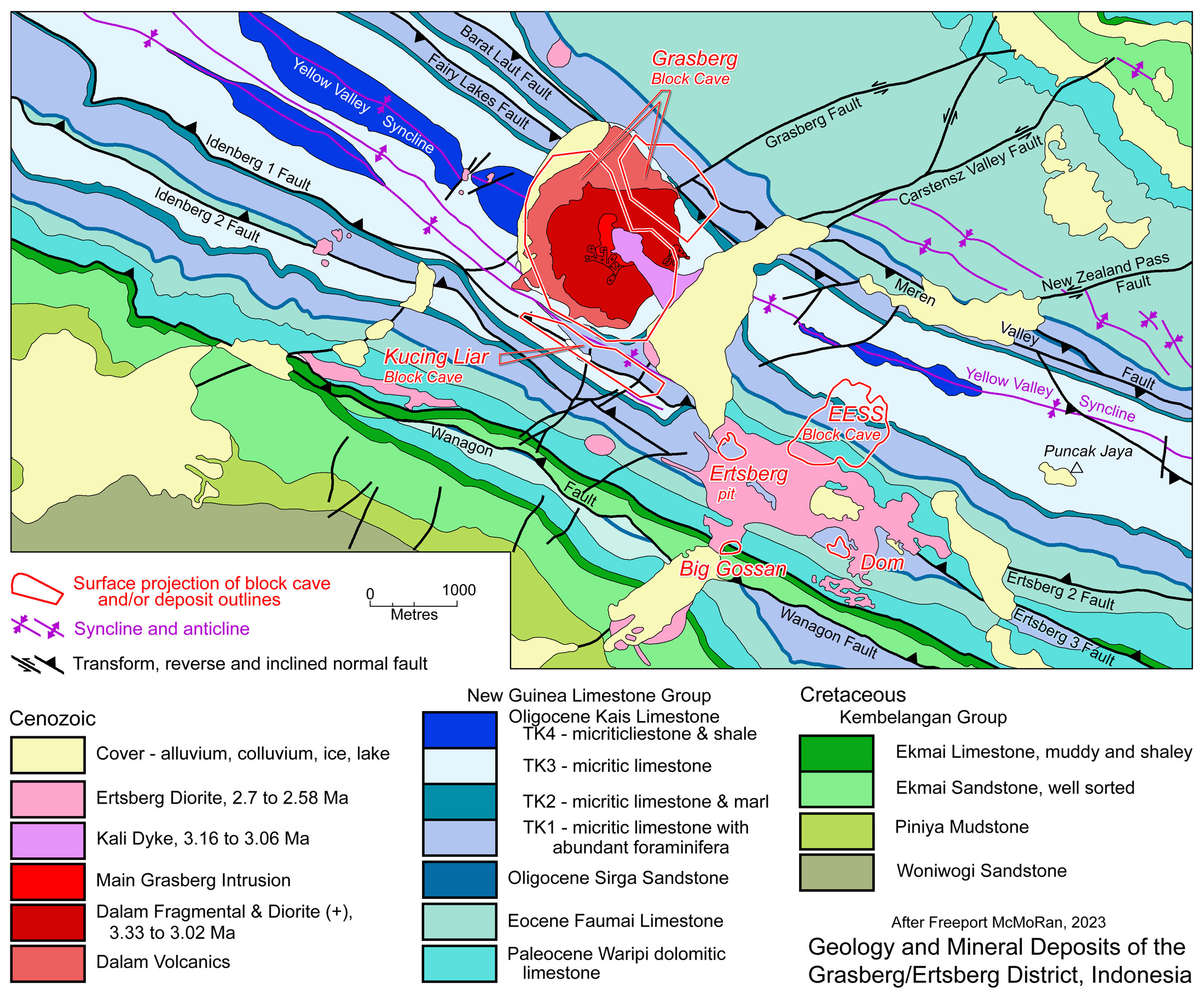
The Gunung Bijih (or Ertsberg) Mining District of West Papua (formerly Irian Jaya) contains a diverse group of large porphyry and skarn altered ore deposits. The district incorporates the super-giant Grasberg porphyry copper/gold deposit associated with the 3.5 to 3.0 Ma Grasberg Igneous Complex; porphyry ores of the 3.1 to 2.65 Ma Ertsberg Diorite 2 km to the south; and a series of skarns altered deposits surrounding the latter and between the two intrusive complexes which included the Gunung Bijih/Ertsberg (GB) and Dom skarns, the Gunung Bijih Timur (GBT), Intermediate Ore Zone (IOZ), Deep Ore Zone (DOZ) and Deep Mill Level Zone (DMLZ) and the Kucing Liar and Big Gossan skarns. Together these deposits account for more than 66 Mt of copper and around 4720 tonnes of gold (production + Reserves and Resources in 2020, including Inferred Resources). All are mined as part of a large integrated operation owned by PT Freeport Indonesia. The operation is one of the world's largest gold mines with an annual production (2007) of around 68 tonnes of gold and 560 000 tonnes of copper.
The Gunung Bijih Mining District is located on the slopes of the 4884 m tall mountain Puncak Jaya, ~7 km WSW of its peak. The first European to recognise mineralisation was a young Dutch geologist, Jean Jacques Dozy, who in 1936 was a member of the Colijn Expedition aiming to be the first to climb Puncak Jaya. En route, ~100 km from the coast, at an altitude of 3600 to 3800 m, he mapped the unusual magnetic, high grade copper mineralisation (chalcopyrite-rich magnetite skarn) that formed a small mountain he named Ertzberg, rising from an alpine swamp. In passing, he also described a rounded grassy hill, further up the valley devoid of trees, that he named Grasberg. Dozy published a report on these discoveries in Leidsche Geologische Mededeelingen on his return to the Netherlands in 1939, but because of its remoteness and the onset of World War II, it received little attention. This report came to the notice of Forbes Wilson, the Freeport Sulphur Exploration Manager on a trip to Europe in the late 1950s. It piqued his interest, prompting him to gain management approval to mount an expedition to Papua to inspect the Ertzberg in 1960. In 1967, PT-Freeport Indonesia entered into an initial 30 year Contract of Work (COW) with the Government of Indonesia to mine the the Gunung Bijih/Ertsberg ore body. It was drilled it out in the late 1960s and a reserve of 33 Mt @ 2.5% Cu, 0.8 g/t Au estimated (Wilson 1977), before commencing open pit mining, with the first production shipped in 1972. Over the succeeding years PT Freeport Indonesia found Gunung Bijih Timur/Ertsberg East, 1 km east of the Gunung Bijih open-pit, and progressively outlined the deposits of the Ertsberg East Skarn System and began block cave mining in 1981. The Dom orebody was discovered and drilled in the 1970s.
During this period, mine geologists, particularly Chief Geologist Dave Potter, had looked curiously at the enigmatic treeless, grass covered mountain Grasberg from the Ertsberg geology office window. With low budgets and limited resources, in 1985 they managed to drill a single 200 m diamond core hole into the side of the mountain, with discouraging results. Undeterred, Potter took a helicopter to the top of Grasberg in 1988 and took a series of rock samples, which assayed 'unusually high' gold values. Management was persuaded to approve a 5 hole diamond drilling program. The first four holes encountered good gold and copper values but with no near surface enrichment as had been hoped for. The final 611 m hole intersected 591 m @ 1.69% Cu, 1.7 g/t Au. Mining commenced in the Grasberg Open Pit from 1990, and continued until 2019, before switching to block cave.
Since 1990, the Big Gossan (BG), Kucing Liar (KL) and Deep Mill Level Zone (DMLZ) deposits have been found. Open stope mining commenced at Big Gossan in 2104, whilst Block Cave extraction started on the Deep Mill Level Zone (DMLZ) deposit in 2015. Block cave development began at Kucing Liar (KL) in 2021. The Grasberg Open Pit transitioned to Block Cave immediately below in 2019.
The Grasberg/Ertsberg operation in the Gunung Bijih Mining District is operated by PT Freeport Indonesia, a limited liability company, registered in the Republic of Indonesia, which until 1995 was owned by the US based Freeport-McMoRan Copper and Gold Inc.
As of 31 December 1995, Freeport-McMoRan Copper and Gold entered into an agreement with Rio Tinto Zinc plc, whereby Rio Tinto took a 16.6 per cent interest in the former, and as a consequence a 14.3 per cent share in PT Freeport Indonesia. As a condition of this agreement, Rio Tinto Zinc was required to pay PT Freeport Indonesia a cash flow from specified annual amounts of copper, gold and silver through to 2021, calculated by reference to the Proved and Probable Reserves as of December 31, 1994, plus also pay 60% of all remaining cash flow. However, from 1 January 1998, Rio Tinto Zinc was entitled to a direct 40% share in Resources discovered after 31 December 1994. The benefits of this agreement passed to Rio Tinto plc in 1997, but was scheduled to expire in 2021 when the then current COW was scheduled to expire, with an option of two ten-year extensions.
Tectonic and Structural Setting - The Gunung Bijih Mining District is located within the uplifted, shortened and imbricated core of the island of New Guinea that is the New Guinea Fold and Thrust Belt, known as the Central Range Fold Belt in West Papua, Indonesia. This uplift has resulted from a variably compressional and oblique translational regime that has prevailed since at least the Miocene, involving the convergence between the Australian and Caroline Sea plates. The Grasberg and Ertsberg mines are situated in the fold belt core, within a few kilometres of Puncak Jaya, the highest mountain on the Australian Plate. It lies within the fold belt that overlies the northern margin of the thick stable platform of the northward migrating Australian Cratonic Plate. The northern margin of that plate is within 200 km the current north coast of New Guinea.
North-dipping, intra-oceanic subduction of oceanic crust on the leading edge ahead of the Australian Cratonic Plate, began subducting below the oceanic Caroline Sea Plate prior to 20 Ma. Sediment accretion began after the continental rise and slope strata reached the trench and were uplifted, followed by massive offs-craping as shelf strata entered the trench at ~8 Ma (Cloos, 2008). Cloos (2008) suggests collisional jamming of the subduction zone by the thick underthrusting Australian crust-capped plate was accompanied by obduction of the Caroline Sea Plate over the accretionary wedge on the leading edge of the Australian Plate. This is evidenced by extensive deformed ophiolites overlying a metamorphosed mélange of post-Miocene sediment. As this jamming progressed, the subducted oceanic crust on the leading edge of the Australian Plate was delaminated, detached and sank into the mantle. This was followed by adiabatic decompression melting that generated a new magma reservoir from the recently fertilised asthenosphere that flowed into the void. This jamming triggered a new, south dipping intra-oceanic subduction zone to develop several hundred kilometres to the north. However, while the jammed compressive stress was absorbed by the new subduction zone, the oblique convergence between the Caroline Sea and Australian plates was absorbed in the late Cenozoic (<5 Ma) by major sinistral strike-slip faults, particularly the steep, 800 km long, composite Yapen Fault Zone near the earlier subduction zone (e.g., Saputra, 2022, Fuji et al., 2021).
Some 200 km to the NW of Grasberg, the overall WNW-ESE trend of these structural elements, and those detailed below, is interrupted by the major SW-NE structure, the Waipona Trough (Pubellier and Ego, 2002) that separates the 'birds head' and 'body' of the island of New Guinea. This structure has acted as both a sinistral transform and extensional rift, and truncates the Central Range Fold Belt. The next major mapped, sinistral, transform, ~400 km to the east of Grasberg, trends NNE-SSW, but only offsets, and does not truncate the fold belt. It constitutes a broad, ~20 km wide corridor that straddles the Ok Tedi Transfer and the Mount Kasa Lineament (e.g., Hill et al., 2002).
In West Papua, Indonesia, the southern margin of the Central Range Fold Belt, is defined by the major south vergent Mapenduma Thrust that is ~30 km south of Grasberg. To the north, the sedimentary sequence of the fold belt is separated from the obducted pre-Eocene ophiolites of the Caroline Sea Plate by the south vergent Oligocene to early Miocene Derewo Metamorphic Belt.
The Arafua Plarform to the south of the Mapenduma Thrust comprises an older Proterozoic Australian basement overlain by a sequence of Neoproterozoic, Cambrian, Ordovoician, Silurian to Devonian, and Permian to Middle Jurassic shelf sediments that comprise conglomerate and sandstone, shale and dolomite/limestone. The uppermost of these are the Early Triassic to Cretaceous Kembelangan Group described below.
The Derewo Metamorphic Belt is a >500 km long, ~10-30 km wide, roughly east-west trending terrane composed mostly of slate and phyllite, on the northern flank of the Central Range.
The southern margin of the Central Range Fold Belt is occupied by the Mapenduma Anticline which exposes a thick shallow north-dipping Neoproterozoic to Triassic sequence, similar to that below the Arafua Platform over a north-south width of ~20 km. From the top of this sequence to the Derewo Metamorphic Belt, exposure is limited to the Kembelangan Group and overlying Tertiary New Guinea Group, all of which are shelf sediments, except to the north, where ~25 km to the north of Grassberg, these are overlain by the late Miocene, 5 to 7 Ma Minjauh Volcanic Field comprising a thick section of calc-alkaline to low-K shoshonitic volcanic rocks and associated volcanogenic deposits, as well as several shallow level intrusive complexes.
The Grasberg Igneous Complex is intruded into Tertiary limestones in the axis of the Yellow Valley Syncline, which marks the core of the Central Range Fold Belt, with Puncak Jaya being the highest point on the southern limb, into which the Ertzberg Diorite was intruded. The limbs of the syncline dip at 50 to 80° inwards.
Ductile and and brittle deformation contributed to folding. The bulk of the faulting within the Central Range Fold Belt would appear to be south vergent reverse faulting, with the same sense of displacement as the bounding Mapenduma Thrust and Derewo Metamorphic Belt. These reverse faults are developed parallel to the regional WNW-ESE fold trend, some with kilometre-scale offsets, followed by later strike-slip left-lateral movement.
However, deformation straddling the Yellow Valley Syncline is characterised by a series of faults, also with a WNW-ESE trending strike, that dip steeply inward towards the axis of the syncline, i.e., in the Grasberg-Ertsberg mine area, the Wanagon, Batu Big Gossan, Idenberg 1 and 2, and Ertsberg 2 and 3 faults, on the south limb all dip to the north, similar to the regional reverse fault trend. In contrast, the Fairy Lakes, Barat Laut and Meren Valley Faults on the north limb, instead dip to the south. This set of faults is also developed parallel to the regional and local fold trend. All of the WNW-ESE sets are cut in places by a second set that trend NE-SW with sinistral offsets, ranging from a few metres to more rarely a few hundred metres (e.g., the Grasberg, Carstensz and New Zealand Pass faults).
Mapping suggests all of these fault sets have preceded intrusion of both the Grasberg Igneous Complex and the Ertsberg Diorite.
The structure associated with the Yellow Valley Syncline, namely a syncline with faults on its two limbs dipping in opposite directions, towards the fold axis, would be consistent with a trans-tensional flower structure. Such a structure could have developed along a zone of sinistral strike slip faulting related to the oblique stress field that generated the Yapen Fault Zone family of structures, and the second stage strike-slip faulting observed on the main NNW-SSE set of faults described above. Cloos (2008) notes that structural analysis has revealed abundant evidence that the Grasberg Igneous Complex was intruded into a pull-apart zone generated by the Riedel system connecting parallel WNW-ESE strike-slip faults and the NE-SW trending Grasberg Fault. It is considered likely that the north dipping faults on the southern limb of the Yellow Valley Syncline are reactivated, and partially restored thrusts.
The Grasberg Igneous Complex is intruded into less favorable host rocks of the Kais Limestone in the core of the Yellow Valley Syncline, flanked closely on both the NNE and SSW limbs by the inward dipping contact with the underlying favourable Faumai Formation. The latter hosts the Kucing Liar mineralisation adjacent to the Idenberg 1 Fault and 500 m across strike from the Grasberg Igneous Complex. The Ertsberg Diorite is elongated parallel to, and within the SSW fold limb of the same syncline, predominantly intruding the favourable Tertiary Waripi formations which host the Ertsberg, Ertsberg East Skarn System and Big Gossan deposits.
The sequence in the Gunung Bijih Mining District comprises thrust wedges of Proterozoic and Palaeozoic rocks in the south, overlain by Mesozoic marine clastics and Tertiary carbonates and platform sediments. In the mine area, the Mesozoic is represented by >700 m of predominantly siliciclastic quartz sandstones, shales and the uppermost shale, sandstone and limestones of the Triassic to Cretaceous Kembelangan Group; overlain by the Tertiary New Guinea Group.
The Kembelangan Group comprises, from the base:
• Kopai Formation - over 300 m of Early Triassic to Early Jurassic glauconitic sandstone, interbedded with siltstone, mudstone,carbonaceous shale, conglomerate, calcarenite and calcilutite;
• Woniwogi Formation - over 500 m of Late Jurassic to Early Cretaceous coarse clastic sediments, which include well sorted sandstone to massive orthoquartzite with siltstone and mudstone interbeds;
• Piniya Formation - ~600 m of Late Jurassic to Early Cretaceous interbedded shale and siltstone, with intercalation of very fine to fine sandstone, containing glauconite and pyrite;
• Ekmai Formation - the uppermost unit of the Kembelangan Group, which has been subdivided into three members, from the oldest, the
i). 600 m thick Ekmai Sandstone which is arkosic in nature.
ii). 100 m thick Ekmai Limestone, a calcareous mudstone, that is altered to skarn and hornfels;
iii). 3 to 5 m thick Ekmai Shale, which forms a marker horizon that contains hornfels within the district and is seldom mineralised, even where units above and below have high-grade copper and gold skarn;
Both the limestone and sandstone commonly host disseminated to fracture-controlled, ore-grade mineralisation where they underlie the larger skarn ore bodies.
The overlying Tertiary New Guinea Group, which is ~1700 m thick, has been subdivided into the:
• Paleocene Waripi Formation, composed of ~300 m of anhydrite nodule-bearing dolomitic limestone, containing thin but laterally continuous quartz sandstone beds;
• Eocene to Lower Oligocene Faumi Formation, which comprises ~200 m of massive-bedded, clean limestone; followed by,
• Oligocene Sirga Formation, which comprises ~35 m of moderately sorted quartzose and calcareous sandstones, shales and coal;
• Late Oligocene to Miocene Kais Formation (or New Guinea Limestone), the uppermost part of the New Guinea Limestone Group, comprising an ~1200 m thick, well bedded limestone succession with lesser intercalations of quartz sandstone, carbonaceous claystone, siltstone and shale. Within the Gunung Bijih Mining District, it has been subdivided into the: i). TK1 unit, a micritic limestone with abundant foraminifera; ii). TK2 unit, a micritic limestone with interbedded marl; iii). TK3 unit, composed of micritic limestone; and iv). TK4 unit, comprising micritic limestone with shale interbeds.
The Waripi Formation and to a lesser degree, the Faumi Formation are the principal hosts to skarn mineralisation in the district.
Around 16 Pliocene hypabyssal intrusions have been delineated in the Gunung Bijih Mining District, mainly dykes, sills or plugs with areas of outcrop generally ranging from a few to several hundred square metres. The Ertsberg Diorite and the Grasberg Igneous Complex (GIC) are the largest with areas of a few square kilometres. These intrusions have similar chemistries, although the Grasberg Igneous Complex is largely porphyritic whereas the bulk of the Ertsberg Diorite is equigranular. McDowell et al., (1996) reported 13 K-Ar ages from these intrusions that indicate magmatic activity in the district ranged from 4.4 to 2.6 Ma (mean 3.22 Ma). The Grasberg Igneous Complex has returned dates of 3.2 to 2.8 Ma (K-Ar; McDowell et al., 1996) and 3.33 to 3.02 (Ar-Ar - Pollard et al., 2001).
The 2.5 x 1 km Ertsberg Diorite is mainly an equi-granular quartz monzodiorite, with lesser biotite-pyroxene diorite and porphyritic quartz monzonite dykes which cut the other two phases. This intrusive complex has been dated at 2.7 to 2.58 Ma (Pollard et al., 2005), and hosts, or is rimmed by the Ertsberg skarn and the Ertsberg disseminated ores, the latter apparently related to a set of 5 to 15 m wide quartz-monzonite dykes (Friehauf, Titley and Gibbins 2005).
The Grasberg Igneous Complex (GIC), around 2 km to the NNW, is an upwardly flaring funnel shaped volcanic vent or diatreme, with an intrusive core, the Main Grasberg Intrusion, cut by the late Kali Intrusion dykes. Prior to mining it had dimensions of ~1.7 x 2.4 km at surface, contracting to 800 m diameter 1000 m below, and is composed of:
i). The early Dalam Igneous Complex or Diatreme comprising a 3.33 ±0.12 Ma lower Dalam Diorite or monzodiorite porphyry (Pollard et al., 2005); 3.02 ± 0.03 Ma (Pollard et al., 2005) intrusive phase below ~3500 m elevation; and an upper andesitic phase which comprises matrix supported breccias, pyroclastics, volcaniclastic sediments and trachy-andesite lavas at shallower levels of the complex. Both the upper andesite and lower diorite are fragmental breccias and are strongly altered in several stages (MacDonald and Arnold, 1994). On the margins, surrounding the Main Grasberg Intrusion, the upper andesitic phase is differentiated into a). a bedded volcanic unit, which is a thin, varying from a few tens of metres up to 300 m thick, flat lying, band of bedded, water-lain volcaniclastic sediments that occur along the northeast and southwest edges of the complex, b). a unit of coarse andesite porphyry flows cut by dykes and sills, the Dalam Andesite, and c). the core of breccias and pyroclastics, the Dalam Fragmentals. The Dalam Volcanic and Dalam Fragmentals are, respectively, polymict and monomict matrix supported breccias, typically containing 5 to 10%, but locally up to 30% clasts. The Dalam Igneous Complex is interpreted to represent an explosive, gas driven, space-generating eruption, which has produced a maar complex that has vented to the surface. It is now the un-eroded roots of a 2 to 3 km tall composite stratovolcano which has been removed by the strong uplift that produced the ~5000 m Puncak Jaya and the surrounding mountain range.
ii). The Main Grasberg Intrusion (MGI) which is interpreted to have been passively emplaced as a non-venting plug into the centre of the Dalam phase rocks. It is characterised by coarse, relatively equigranular textures and a near lack of fragments. This is, in turn, divided into the a). Early Main Grasberg - a 600 x 430 m stock of porphyritic quartz monzodiorite with a vertical extent of more than 2800 to 4250 m; and the b). Late Main Grasberg - a 900 m diameter stock of porphyritic quartz monzodiorite with associated dykes and a vertical extent of 2800 to 3800 m.
Dalam volcanic pyroclastic and flow-dome rocks outcrop and covered much of the pre-mining surface of the GIC. An erosional window in the south-central portion of the deposit exposed MGI-related quartz stockwork hosted copper and gold mineralisation at the surface.
iii). Kali Intrusion - which occurs as a nest of what are described as quartz monzodiorite porphyritic dykes with crowded plagioclase-hornblende-biotite phenocrysts, and disseminated magnetite, set in a finer groundmass of quartz, feldspar and biotite. It forms an irregular 600 x 250 m stock-like dyke with a vertical extent of >4000 m, the younger phases of which truncate the ore body and mark the closure of the main igneous system. The intrusion has been divided into (Pollard and Taylor et al., 2002): a). Kali I Dykes (3.16 ±0.06 and 3.12 ±0.04 Ma; Ar/Ar; Pollard et al., 2005), which are by far the most abundant, comprising a fine-grained porphyritic rock with ~40 to 50 vol.% phenocrysts that are commonly partially aligned. The phenocryst are variable and include plagioclase, amphibole, biotite, clinopyroxene, magnetite and rare quartz; b). Kali II Dykes - (3.09 ±0.03 Ma; Ar/Ar; Pollard et al., 2005) are medium-grained, seriate-textured to weakly porphyritic, with a generally <2 mm grain size, but ranging up to 1 and occasionally 10 mm. The principal ferromagnesian minerals are 10 to 15 vol.% amphibole, biotite and magnetite. c). Kali III Dykes - that are typically cm to tens of cm in width cutting Kali I dykes and are an aplitic granite with 30 to 35 vol.% each of quartz, K feldspar and plagioclase. These dykes are structurally controlled, tabular units which intrude the complex from a separate stock SE of the Grasberg Igneous Complex.
Pollard et al. (2005) recognise Post-Kali intrusives (3.06 ±0.03 Ma; Ar/Ar; Pollard et al., 2005) that comprise an altered diorite dyke crosscutting a Kali I dyke. It occurs as a porphyritic microdiorite with ~50 vol.% phenocrysts to 4 mm of plagioclase and biotite, with minor magnetite and apatite set in a finer grained matrix. Secondary biotite is developed at the expense of some 50 vol.% of the primary biotite, and it is cut by minor veins of anhydrite-quartz veins as well as sparse chalcopyrite.
No volcanic deposits extend beyond the mapped limits of the GIC into the immediate surrounding district. However, prior to mining, part of the Grasberg Igneous Complex was overlain by remnants of a volcanic edifice that included volcaniclastic rocks and hornblende andesite flows or domes. The volcaniclastic rocks were well to poorly bedded and sorted and include tuffaceous components with eutaxitic textures and accretionary lapilli, carbonized wood fragments, and bomb and splash structures that indicate, in part, a surficial aqueous environment of deposition (MacDonald and Arnold, 1994). Pollard and Taylor (2003) suggested these formed late in the history of the complex as they were not subjected to the intense potassic and other alteration and Cu-Au mineralization of the upper Dalam pyroclastics and volcaniclastics.
The 1 km wide core of the Grasberg deposit has a strong associated potassic alteration suite of K feldspar-biotite-quartz-magnetite, grading out to a propylitic halo of epidote ±chlorite-magnetite-calcite, represented by pockets and remnants. Strong magnetite (>8%) occupies a 600 x 300 m core to the potassic zone. The potassic assemblage has been overprinted by intense phyllic alteration to form an exterior annular zone, ~500 m across, which is dominated by sericite+anhydrite+pyrite with small amounts of kaolinite, in places to within 400 m of the centre of the system. A 100 m wide zone of brecciated marble surrounds the GIC.
There were a number of pulses of mineralisation associated with the Grasberg Igneous Complex (GIC) and Grasberg porphyry deposit. Whilst Cloos (2008) recognises just 2 main stages of fluid flow and mineralisation associated with the GIC, Pollard et al. (2005) have described how this is manifested in the different lithologies of the complex. According to Cloos (2008), the Stage 1 mineralisation post-dates emplacement of the Main Grasberg Intrusion, but predates the Kali phase dykes, which were concurrent with Stage 2 mineralisation. Stage 1 was the more intense, causing extensive pervasive alteration, which created the concentric mineral zonation and a substantial fracturing and veining event. It has been subdivided (Cloos, 2008) into: i). Sub-stage 1A, pre-ore veins, largely composed of quartz and/or magnetite, and ii). Sub-stage 1B, ore-related veins, varying from a central zone of mono-minerallic chalcopyrite, passing outwards to quartz + pyrite + anhydrite ±chalcopyrite, then to pyrite ±quartz veins with sericite alteration selveges up to a few cms wide.
Dalam intrusive rocks are partially altered to pale brown, texturally destructive, and fracture-controlled K feldspar. Fragments of these altered lithologies have been observed within an igneous matrix interpreted to be the Main Grasberg Intrusion (MGI), suggesting some pre-ore K feldspar and biotite occurred before deposition of the MGI. These observations had led MacDonald and Arnold (1994) to conclude a major episode of pervasive alteration and disseminated Cu-Au mineralisation has accompanied the Dalam magmatism, pre-dating intrusion of the MGI. K feldspar is also irregularly distributed within the MGI, and, where more intensely developed, has also replaced the phenocrysts and obliterated the original texture of the rock. Biotite occurs as micron-scale crystals within the altered porphyry matrix. Secondary magnetite is mainly found as fine grained alteration of igneous rocks and of earlier alteration styles adjacent to numerous mm-scale cracks (Pollard et al., 2005).
The Stage 2 veins were emplaced coeval with the Kali dykes which post-date nearly all economic mineralisation. These veins are commonly predominantly composed of quartz, biotite and anhydrite, are much less abundant than those of Stage 1, with only very limited associated pervasive alteration. Where hosted by early Kali dykes, Stage 2 has numerous magnetite, but few pyrite veins with minor chalcopyrite, whereas the later Kali has numerous pyrite but few magnetite veins. The Stage 2 hydrothermal system had a significant sulphur content (Cloos, 2008).
Pollard et al. (2005) describe the the Grasberg mineralisation as comprising abundant, generally 0.5 to 4 cm thick, anhydrite-quartz veins with K feldspar, biotite, amphibole, apatite, chalcopyrite, bornite and pyrite. These veins are characterised by lilac to pale purple anhydrite. The quartz is white and has a distinctive, coarsely granular to comb texture. Molybdenite veins in the same section of the deposit are characteristically ~1 mm thick and solely composed of molybdenite, commonly occurring along, and sometimes cutting the margins of anhydrite-quartz veins (Pollard and Taylor, 2002).
The bulk of the copper and gold in the Grasberg deposit is contained within chalcopyrite-bornite veins that are concentrated adjacent to the Kali intrusions, a much lower density of which occur within both the Kali dykes, and towards the perimeter of the GIC. These veins are generally <0.5 cm thick, and are dominantly composed of chalcopyrite and bornite, with native gold, hematite, and locally minor quartz. They commonly exploit pre-existing quartz veins by fracturing and infilling them along their centrelines. Pyrite veins have been observed to cut molybdenite and chalcopyrite veins.
A zone of heavy sulphides is found near the northeastern margin part of the Grasberg Igneous Complex, mainly below an elevation of 3000 m but tapering upward to the surface. It consists of zones of massive, fine-grained replacement pyrite grading into veins in peripheral zones with less well-developed alteration. It is characterised in its core by quartz veining linked to intense silica alteration of the wall rocks, with drill core intersections of 100 m or more of fine-grained grey-white quartz with veins up to 5 cm thick. Prominent dark, fine-grained sericite-silica alteration occurs in the outer parts of the Grasberg Igneous Complex over the same vertical interval, post-dating the main K feldspar and silica alteration of the main copper zone, overprinted, in turn, by pyrite of the 'heavy sulphide zone'. This pyrite replaces carbonate and silica, sericite, feldspar and magnetite-altered intrusive rocks. The pyrite contains minor amounts of intergranular chalcopyrite.
The deposit also contains high sulphidation Cu-rich mineralisation and alteration in the deeper parts of the complex, characterised by an assemblage that includes andalusite ±rare corundum as an alteration of feldspar phenocrysts, but mostly white sericite-argillic alteration and vuggy quartz veins interpreted as the result of leaching anhydrite from zones of quartz-anhydrite veining. The associated mixed copper sulphide is largely composed of chalcopyrite, bornite, nukundamite (Cu3.37, Fe0.66 S3.97), digenite-chalcocite, covellite, and pyrite. These sulphides occur in discontinuous veins and in cavities partially lined by crystalline quartz that has been overgrown by late muscovite crystals. Molybdenite, chalcopyrite, nukundamite, pyrite, covellite, and minor valleriite are found in cavities, with additional late covellite in cracks cutting earlier formed minerals. Covellite is also found in the outer parts of the Grasberg Igneous Complex, most commonly as mm scale veins, some of which also contain enargite (see Pollard and Taylor, 2002). The high sulphidation zone is poorly defined, but appears to post-date the 'heavy sulphide zone' pyrite. A very late native sulphur phase infills discontinuous narrow, 1 to 2 cm fractures and vugs of fine-grained pyrite-marcasite-covellite.
Spatially and temporally, the observations above result in a pattern where the bulk of the copper ore occurs as stockwork veins and veinlets and disseminations that postdate the potassic alteration, but predates the phyllic/high sulphidation phase. Mineralisation occurs as a horseshoe shaped mass surrounding the Kali intrusive contact, extending outward to the contact between the Grasberg Igneous Complex and the Kais Formation contact, and downward from the surface at an elevation of 4200 m, to below 2700 m asl. In general, it comprises an inner annulus that extends outward for 100 to 150 m from the barren late Kali core, and contains >3% (much in excess of 4%) Cu equiv.. This is surrounded by a 150 to 250 m wide interval of 1 to 3% Cu equiv. ore with an outer diameter of 500 to 800 m. Copper minerals are dominated by chalcopyrite and bornite. Gold is closely associated with chalcopyrite and bornite and some is with digenite. High Au grade zones always coincide with the high Cu grade zone. A rind of strong pyrite forms at the contact between the GIC and the enclosing Kais Formation limestone, with no sulphides extending further into the limestone except as skarns in faults that the GIC intersects. A halo of marble development extends outward from the intrusive complex for from 50 to 150 m in the Kais Formation, extending further out along faults, and being continuous between the Grasberg Igneous Complex and the Ertsberg Diorite in the Faumai and Waripi formations.
Mining activity associated with the Grasberg Igneous Complex has taken place first from the Grasberg Open-pit (GRS_OP), between 1990 and 2019, and from the same year, from the Grasberg Block Cave (GBC) immediately below.
The Kucing Liar Skarn is developed over a strike length of ~1500 m, located ~500 m across strike from the SW margin of the Grasberg Igneous Complex. It is hosted by both the Tertiary Waripi Formation and the Cretaceous Ekmai Formation. Phlogopite alteration associated with Kucing Liar mineralisation has been dated at 3.41 ±0.03 Ma, the oldest in the district. However, the age of this phlogopite is within the error range of that of secondary biotite alteration (3.33 ±0.12 Ma) in the fine-grained Dalam intrusion of the Grasberg mineralisation, and it is therefore possible it may be linked to an early pulse of the Grasberg Igneous Complex hydrothermal event. The Kucing Liar skarn mineralisation is located in the hanging wall of, and parallels, the steeply SW dipping to vertical, NW-SE trending Idenberg 1 Fault zone that passes between the GIC and the Ertsberg Diorite, and is along strike from the latter. However, it is closer to the former, both spatially and temporally, and is immediately adjacent to, and overprinted by the vein stockwork of the Grasberg Block Cave (GBC) porphyry mineralisation. This raises the question as to whether it is a diatal product of the GIC event, or related to fluids from a deeper source emanating from the Idenberg 1 Fault zone. It was originally estimated to contain >225 Mt @ 1.42% Cu, 1.57 g/t Au (Widodo et al., 1998), a figure that has been subsequently substantially increased (see reserves/resources below). See the separate Kucing Liar record for a description of the geology, alteration and mineralisation of the deposit.
Mineralisation/deposits associated with, or in the vicinity of, the Ertsberg intrusive includes:
• Gunung Bijih (GB) (Ore Mountain), the original Ertsberg discovery that was found in 1936, re-discovered in 1960, and mined from 1972, with an initial resource of 33 Mt @ 2.5% Cu, 0.8 g/t Au. When mining ceased in 1989, it had produced 29.3 Mt of ore @ 2.33% Cu, 0.53 g/t Au. The deposit is surrounded as an enclave by Ertsberg Diorite near its NW extremity;
• Gunung Bijih Timur (GBT), 'Ore Mountain East', discovered 1 km to the east by geologists mapping outcrop in the early 1970s during the evaluation of the GB. Following drilling in 1975, it was mined as a block cave from 1981 to 1994 after initial open pit operations, but was found to be just the upper portion of the larger Ertsberg East Skarn System (EESS). The Ertsberg East Skarn System consists of three vertically stacked orebodies, in descending order the Gunung Bijih Timur (GBT), Intermediate Ore Zone (IOZ) and Deep Ore Zone (DOZ) (Freeport McMohRan, 2023). These bodies are divided into an upper monticellite-diopside-forsterite skarn in the GBT and much of IOZ, and a lower forsterite-diopside skarn in the lowermost IOZ and DOZ, corresponding to the contact between the calcareous Faumai and dolomitic Waripi Formation host sediments respectively. However, much of the DOZ is a stockwork endoskarn hosted by the Ertsberg Diorite. Retrograde assemblages include tremolite-actinolite, phlogopite, talc, serpentine and chlorite. Anhydrite increases with depth (Rubin, 1996). The largest of this stack, the DOZ, began mining as an open stope mine in 1989 and was converted to block caving in 2000, and was depleted by the end of 2021. The endoskarns of the Ertsberg East Skarn System has been dated at 2.71 Ma, while the exoskarns have returned ages of 2.58 Ma (Pollard et al., 2005).
• Ertsberg Stockwork Zone of Friehauf, Titley and Gibbins (2005), comprises mineralisation and alteration within the Ertsberg Diorite, inboard, and part of the upper Ertsberg East Skarn System (EESS). It is characterised by i). early feldspar stable potassic alteration with hairline bornite veining, ii). transitional green sericite veins with chalcopyrite, chalcopyrite-pyrite veins and endoskarn development and iii). late quartz-sericite-pyrite ±chalcopyrite. This mineralisation is spatially associated with 5 to 15 m wide, east-west striking, dykes of porphyritic hornblende monzonite that cut equigranular Ertsberg diorite. Hornblende > biotite, a much higher content of sphene, a paucity of broken phenocrysts, and the aplitic groundmass distinguish the porphyry dykes in the Ertsberg Stockwork Zone from the finer-grained groundmass Kali dykes of the Grasberg deposit.
• The Deep Mill Level Zone (DMLZ) was discovered by an exploration program that began in 2003, and culminated in a block cave operation that commenced in 2015. It represents the deepest portion of the Ertsberg East Skarn System and is hosted by both the Ertsberg Diorite and Tertiary sedimentary rocks. The igneous-hosted sections occur as vein stockworks and disseminations of copper sulphides, dominated by chalcopyrite and to a lesser extent bornite, whilst the sedimentary-rock hosted ore is 'magnetite-rich, calcium/magnesian skarn' replacement mineralisation, whose location and orientation are strongly influenced by major faults and by the chemistry of the carbonate rocks along the margins of the intrusion.
• The Dom deposit was discovered by geologists mapping outcrops in the early 1970s during the evaluation of the Gunung Bijih (GB) deposit, and was drilled in 1976 to 1977. It is hosted by skarn within the Faumai Limestone, partially enclosed by the Ertsberg Diorite on it's SW margin, near it's SE extremity, ~1600 m SSE of Gunung Bijih and a little over 500 m SW of the Ertsberg East Skarn System. Geotechnical studies indicated open pit mining would jeopardise significant infrastructure and the resource it represents has been relegated to a Mineral Resource, rather than a Reserve. In 2004, the Dom skarn was estimated to have contained >70 Mt @ 1.4% Cu, 0.4 g/t Au (Friehauf, Titley and Gibbins, 2005).
• The Big Gossan (BG) lies on the southwestern extremity of the Ertsberg Diorite. Mineralisation is associated with a series of 3 to 4 Ma granodioritic dikes which have intruded close to the near-vertical faulted contact between the Shale Member of the Cretaceous Ekmai Formation and the stratigraphically overlying Paleocene Waripi and Eocene Faumai Formations. The bulk of the mineralisation and alteration is found in the purer carbonate rocks of the Waripi Formation, although biotite and calc-silicate hornfels alteration also occurs in the adjacent footwall rocks. Prograde skarn alteration consists dominantly of pyroxene and garnet. Skarn alteration is zoned in three dimensions relative to the Ekmai-Waripi contact, the assumed fluid conduit. Proximal zones are characterised by abundant dark red-brown garnet and pale iron poor pyroxene. Intermediate zones contain sub-equal amounts of relatively coarse-grained, green pyroxene and brown garnet, whilst distal skarn is dominated by dark green, iron-rich pyroxene. At the skarn-marble contact, retrograde alteration, mostly amphibole, epidote and sulphide minerals (mainly pyrite and pyrrhotite) are abundant. Chalcopyrite and anhydrite are present to varying degrees in all skarn zones (Meinert et al., 1997). In 2004, Big Gossan was estimated to contain 33 Mt @ 2.81% Cu, 1 g/t Au (Friehauf, Titley and Gibbins, 2005).
With the exception of the Ertsberg Stockwork Zone and sections of the Deep Mill Level Zone (DMLZ), the bulk of the known mineralisation and alteration associated with the Ertsberg Diorite, has been high grade magnetite-rich, calcium/magnesian skarns which are characterised by magnetite and high temperature assemblages, including forsterite, monticellite and minor melilite, as well as diopsidic clinopyroxene, anhydrite and phlogopite. At least 3 garnet varieties have been recognised although these decrease with depth. Talc, serpentine, tremolite-actinolite and chlorite are common retrograde minerals. Copper is texturally associated with early retrograde alteration. Chalcopyrite dominated in some bodies (eg. GB and Dom), while bornite is the principal copper sulphide at Gunung Bijih Timur (GBT). The endoskarn of this complex has been dated at 2.71 Ma, while the exoskarns have returned ages of 2.58 Ma (Pollard et al., 2005).
In summary, alteration and mineralisation within the Gunung Bijih Mining District occurred four main pulses between 3.5 and 2.5 Ma, as follows:
• The Kucing Liar event, with alteration that has been dated at 3.41 ±0.03 Ma (Pollard et al. 2005), that may have overlapped the Stage 1A pre-ore alteration of the Dalam Igneous Complex;
• The major Grasberg episode of pervasive alteration and disseminated Cu-Au mineralisation that may have commenced as early as the Dalam Igneous Complex, but which produced major mineralisation after the emplacement of the Main Grasberg Intrusion (MGI) at ~3.19 Ma, and the tailed off during the early stages of the Kali dyke intrusion at 3.16 ±0.06 and 3.12 ±0.04 Ma (Ar/Ar; Pollard et al., 2005).
• The Ertsberg event, in which the Ertsberg Diorite has been dated at 2.67 ±0.03 Ma (Ar/Ar; Pollard et al., 2005), phlogopite from an endoskarn vein within the intrusion gave an age of 2.71 ±0.04 Ma, and phlogopite from the Ertsberg Skarn Cu-Au was dated at 2.59 ±0.15 Ma (Ar/Ar; Pollard et al., 2005).
Note that Mathur et al., (2005) obtained Re:Os ages for molybdenite from Kucing Liar, Grasberg and Ertsberg of 3.01 ±0.02 Ma, 2.88 ±0.02 Ma and 2.54 ±0.02 Ma respectively, consistent with three separate pulses, if not the exact same ages as a result of the different isotopes used.
The intrusive porphyry systems that are temporally and spatially associated with mineralisation in the district, are structurally controlled, and were derived from potassium-rich magmas that were monzodioritic to monzonitic in composition. Exoskarn alteration and associated mineralisation is mainly found within the New Guinea Limestone Group rocks, particularly within the dolomite of the Waripi Formation, but also within the Cretaceous Ekmai limestone and sandstone. The bulk of the mineralisation within the district is hosted by potassic-altered intrusive rocks or within prograde skarn assemblages.
Chalcopyrite is the dominant ore mineral in all ore bodies. Bornite increases with depth in both the Grasberg porphyry system and the Ertsberg Skarn System, but rarely dominates. Covellite is a common mineral in phyllic-altered intervals, and is the dominant copper-bearing mineral in distal portions of Kucing Liar. It is also common in the very local, argillic alteration zones at Grasberg and Kucing Liar, along with other high sulphidation sulphides. Supergene chalcocite was a minor constituent of the low-grade Grasberg ores to as deep as 300 m below the original topography within the highly permeable, anhydrite-depleted 'poker chip' zone. Oxide copper minerals are insignificant in all ore bodies, except Dom, where malachite and chrysocolla are abundant.
Within the Ertsberg East Skarn System, ~80% of the gold is found within the prograde skarn and potassic altered ores, and occurs as free inclusions in chalcopyrite, bornite and digenite. The remainder occurs in pyrite and in silicate gangue minerals. In zones of intense phyllic and/or advanced argillic alteration, early formed gold bearing chalcopyrite is converted to covellite and pyrite, with gold being captured in the pyrite lattice. This is particularly evident in the highly altered ores in parts of Kucing Liar and on the deeper margins of the Grasberg deposit. Gold is typically fine grained and not visible. Silver appears to be largely contained within the crystal lattice of copper-bearing sulphides.
Lead (galena), zinc (sphalerite), and arsenic (arsenopyrite and enargite) are generally found in low concentrations and limited locations. These accessory sulphide minerals are most common at the margins of mineralisation and in distal fault-fracture systems, commonly accompanied by anomalous gold values and generally in areas of elevated pyrite and/or pyrrhotite. Pyrite and lesser pyrrhotite, are relatively uncommon in the potassic alteration and prograde skarn-hosted ores, but can reach high concentrations in the lower grade phyllic and retrograde skarn alteration zones at ore body margins, such as the Heavy Sulphide Zone at Grasberg Block Cave, Kucing Liar, and on margins of the Deep Mill Level Zone and Big Gossan.
Thermal metamorphism of the carbonate rocks is evident in the occurrence of marble aureoles around all the intrusions in the Grasberg minerals district, with marble development extending outward from intrusive contacts for between 50 and 1000 m. The inner boundary is commonly sharp, beginning at either the igneous/sedimentary rock contact or at the skarn front (Leys et al., 2012).
Reserves, Resources and Production
Total Proved + Probable Ore Reserve at the Grasberg/Ertsberg operation at 31 December 2001 (Rio Tinto Annual Report, 2001) were:
2.584 Gt @ 1.13% Cu, 1.04 g/t Au, 3.72 g/t Ag.
The total Measured + Indicated + Inferred Mineral Resource (which are additional to the Ore Reserves) at the same date were:
1.273 Gt @ 0.70% Cu, 0.70 g/t Au, 3.40 g/t Ag.
TOTAL Ore Reserve + Mineral Resource - 3.857 Gt @ 0.99% Cu, 0.93 g/t Au, 3.61 g/t Ag.
Total Proved + Probable Ore Reserve at the Grasberg/Ertsberg operation at 31 December 2007 (Rio Tinto Annual Report, 2007) were:
2.712 Gt @ 1.04% Cu, 0.90 g/t Au, 4.11 g/t Ag.
The total Measured + Indicated + Inferred Mineral Resource (which are additional to the Ore Reserves) at the same date were:
3.049 Gt @ 0.55% Cu, 0.49 g/t Au, 3.20 g/t Ag.
TOTAL Ore Reserve + Mineral Resource - 5.76 Gt @ 0.79% Cu, 0.68 g/t Au, 3.53 g/t Ag.
Production in 2006 from the Grasberg open pit totalled 57.5 Mt of ore, while an additional 19.5 Mt was from underground in the Ertsberg operation.
Total Proved + Probable Ore Reserve at the Grasberg/Ertsberg operation at 31 December 2012 (Rio Tinto Annual Report, 2012) were:
2.424 Gt @ 1.00% Cu, 0.83 g/t Au, 4.24 g/t Ag.
The total Measured + Indicated + Inferred Mineral Resource (which are additional to the Ore Reserves) at the same date were:
2.435 Gt @ 0.62% Cu, 0.55 g/t Au, 3.37 g/t Ag.
TOTAL Ore Reserve + Mineral Resource - 4.859 Gt @ 0.81% Cu, 0.69 g/t Au, 3.80 g/t Ag.
Total Proved + Probable Ore Reserve at the Grasberg/Ertsberg operation at 31 December 2017 (Rio Tinto Annual Report, 2017) were:
1.956 Gt @ 1.05% Cu, 0.83 g/t Au, 4.46 g/t Ag.
The total Measured + Indicated + Inferred Mineral Resource (which are additional to the Ore Reserves) at the same date were:
1.969 Gt @ 0.73% Cu, 0.64 g/t Au, 3.69 g/t Ag.
TOTAL Ore Reserve + Mineral Resource - 3.925 Gt @ 0.89% Cu, 0.73 g/t Au, 4.07 g/t Ag.
Past production - from the first mining at Ertsberg in 1972 to 2018, the Gunung Bijih Mining District has mined ~1.8 Gt of ore containing 16.5 Mt of payable copper and 1650 tonnes of gold (Casten et al., 2020).
UPDATE: 2024
The mines in the Grasberg/Ertsberg minerals district remain under the operational control of PT Freeport Indonesia, a limited liability company, registered in the Republic of Indonesia. On December 21, 2018, however, a transaction between Freeport-McMoRan Inc. and the Indonesian Government was finalised regarding PT Freeport Indonesia’s long-term mining rights and share ownership. Following this transaction, Freeport-McMoRan Inc. has a 48.76% share ownership of PT Freeport Indonesia, with the remaining 51.24% collectively held by PT Indonesia Asahan Aluminum (Persero), an Indonesia state-owned enterprise, and PT Indonesia Papua Metal Dan Mineral, to be owned by PT Indonesia Asahan Aluminum and the provincial/regional government of Central Papua, Indonesia. In the process of finalising this transaction Rio Tinto disposed of its interest in the joint venture.
As part of this transaction, PT Freeport Indonesia was issued a temporary special mining permit (IUPK) with an operating duration of 20 years until 2041. In addition, PT Freeport Indonesia is also required to build smelters with a combined capacity of 2 to 2.6 million tonnes per year.
Operations over the past 50 years comprised:
• The Gunung Bijih/Ertsberg (GB) open pit, initiated operations in 1972, and produced 29.3 Mt of ore @ 2.33% Cu and 0.53 g/t Au by the time mining ended in 1989 (Casten et al., 2020);
• The Grasberg Open-pit (GRS_OP), commenced production in 1990, and ceased operations at the end of 2019, having produced 12.245 Mt of copper metal and 1430 tonnes of gold (Freeport McMohRan, 2023).
• The Grasberg Block Cave (GBC), immediately below the open pit, commenced production in 2019 and over it's life is expected to produce another 7.7 Mt of copper and 435 tonnes of gold (Freeport McMohRan, quoted by Mining Magazine, July 2019).
• The Gunung Bijih Timur (GBT), the upper section of the Ertsberg East Skarn System (EESS), was mined between 1981 and 1994, progressing into the underlying Intermediate Ore Zone (IOZ) between 1994 and 2003;
• The Deep Ore Zone (DOZ) following the higher GBT and IOZ, having commenced mining in 1989, ceased production at the end of 2021.
• The Deep Mill Level Zone (DMLZ) is the lowest portion of the EESS deposits, below DOZ, and has been mined as a block cave since 2015.
• The Big Gossan (BG) is located on the southwest side of the Ertsberg Diorite and started multiple open stoping mining in 2014.
• The Kucing Liar (KL) block cave, a few hundred metres SW of the Grasberg Block Cave, began pre-production development on 2021.
The current operations (2023) are the Grasberg Block Cave (GBC), Deep Mill Level Zone (DMLZ), Big Gossan (BG) and Kucing Liar (KL) mines.
Mineral Resources and Ore Reserves remaining, as at 31 December, 2022 (Freeport McMoRan Technical Report 2023) were:
Mineral Resources - Underground
Grasberg Block Cave (GBC)
Measured + Indicated - 1017 Mt @ 0.57% Cu, 0.46 g/t Au, 3.32 g/t Ag;
Inferred - 87 Mt @ 0.27% Cu, 0.32 g/t Au, 2.69 g/t Ag;
TOTAL - 1104 Mt @ 0.55% Cu, 0.45 g/t Au, 3.27 g/t Ag.
Deep Mill Level Zone (DMLZ)
Measured + Indicated - 661 Mt @ 0.64% Cu, 0.57 g/t Au, 3.33 g/t Ag;
Inferred - 204 Mt @ 0.53% Cu, 0.40 g/t Au, 2.7 g/t Ag;
TOTAL - 865 Mt @ 0.61% Cu, 0.53 g/t Au, 3.18 g/t Ag.
Big Gossan (BG)
Measured + Indicated - 24 Mt @ 1.21% Cu, 0.66 g/t Au, 8.00 g/t Ag.
Kucing Liar (KL)
Measured + Indicated - 1077 Mt @ 0.83% Cu, 0.72 g/t Au, 4.54 g/t Ag;
Inferred - 61 Mt @ 0.52% Cu, 0.46 g/t Au, 2.67 g/t Ag;
TOTAL - 1138 Mt @ 0.81% Cu, 0.70 g/t Au, 4.44 g/t Ag.
Dom
Measured + Indicated - 29 Mt @ 1.20% Cu, 0.32 g/t Au, 7.72 g/t Ag.
Mineral Resources - Open Pit
Grasberg Open Pit (GB)
Measured + Indicated - 14 Mt @ 0.86% Cu, 0.29 g/t Au, 3.65 g/t Ag.
Gunung Bijih Timur (GBT)
Measured + Indicated - 48 Mt @ 0.45% Cu, 0.80 g/t Au, 1.63 g/t Ag.
Dom
Measured + Indicated - 32 Mt @ 1.62% Cu, 0.36 g/t Au, 9.89 g/t Ag.
Inferred - 1 Mt @ 0.86% Cu, 0.08 g/t Au, 2.88 g/t Ag;
TOTAL - 33 Mt @ 1.61% Cu, 0.35 g/t Au, 9.76 g/t Ag.
TOTAL Combined
Measured - 347 Mt @ 0.78% Cu, 0.57 g/t Au, 4.02 g/t Ag.
Indicated - 2555 Mt @ 0.69% Cu, 0.58 g/t Au, 3.88 g/t Ag.
Measured + Indicated - 2903 Mt @ 0.70% Cu, 0.58 g/t Au, 3.90 g/t Ag.
Inferred - 353 Mt @ 0.46% Cu, 0.39 g/t Au, 2.69 g/t Ag;
TOTAL - 3.256 Gt @ 0.68% Cu, 0.56 g/t Au, 3.77 g/t Ag.
Ore Reserves - Underground
Grasberg Block Cave (GBC)
Proved + Probable - 810 Mt @ 1.10% Cu, 0.75 g/t Au, 3.55 g/t Ag;
Ore Reserves - Underground
Grasberg Block Cave (GBC)
Proved + Probable - 810 Mt @ 1.10% Cu, 0.75 g/t Au, 3.55 g/t Ag.
Deep Mill Level Zone (DMLZ)
Proved + Probable - 382 Mt @ 0.75% Cu, 0.62 g/t Au, 3.64 g/t Ag;
Big Gossan (BG)
Proved + Probable - 49 Mt @ 2.27% Cu, 0.95 g/t Au, 13.76 g/t Ag;
Kucing Liar (KL)
Proved + Probable - 381 Mt @ 0.99% Cu, 0.88 g/t Au, 4.59 g/t Ag;
TOTAL Combined
Proved - 496 Mt @ 1.21% Cu, 0.90 g/t Au, 4.12 g/t Ag.
Probable - 1126 Mt @ 0.95% Cu, 0.69 g/t Au, 4.12 g/t Agc
Proved + Probable - 1.621 Gt @ 1.03% Cu, 0.76 g/t Au, 4.12 g/t Ag.
NOTE: Mineral Resources are exclusive of Ore Reserves.
TOTAL Ore Reserve + Mineral Resource, 31 December, 2022 - 4.877 Gt @ 1.02% Cu, 0.63 g/t Au, 3.89 g/t Ag which equals
49.7 Mt of contained copper and 3072 tonnes of gold.
In addition to selected references cited below, more recent information in this description was drawn from: Issel, A., Edgar, I. and Seymour, E.D., 2023 - Summary of Mineral Reserves and Mineral Resources for Grasberg Minerals District Central Papua, Indonesia; a Technical Report prepared by Freeport-McMoRan Inc., 81p.
The most recent source geological information used to prepare this decription was dated: 2023.
Record last updated: 24/4/2024
This description is a summary from published sources, the chief of which are listed below.
© Copyright Porter GeoConsultancy Pty Ltd. Unauthorised copying, reproduction, storage or dissemination prohibited.
Grasberg
|
|
|
Selected References:
|
Casten, T., Johnson, M., Zimmer, C. and Mahayasa, M., 2020 - PT Freeport Indonesia - The transition to underground production: in Castro, R., Baez, F. and Suzuki, K., (Eds.), 2020 MassMin 2020: The Eighth International Conference and Exhibition on Mass Mining, University of Chile, Santiago, Proceedings, pp. 23-38. doi.org/10.36487/ACG_repo/2063_0.03.
|
Cloos, M., 2008 - Grasberg Porphyry Copper-Gold Deposit, Papua, Indonesia - Structural Setting and Hydrothermal System: in The Pacific Rim: Mineral Endowment, Discoveries & Exploration Frontiers, Proceedings of Pacrim 2008 Conference, Gold Coast, Qld, 24-26 November, 2008, pp. 3-6
|
Coutts B P, Susanto H, Belluz N, Flint D, Edwards A 1999 - Geology of the Deep Ore Zone, Ertsberg East Skarn System, Irian Jaya: in Proc. Pacrim 99 Conference, Bali, Indonesia, AusIMM, Melbourne pp 539-547
|
Friehauf K C, Titley S R and Gibbins S L, 2005 - Porphyry-Style Mineralisation in the Ertsberg Diorite, Gunung Bijih (Ertsberg/Grasberg) District, West Papua, Indonesia: in Porter, T.M. (Ed), 2005 Super Porphyry Copper & Gold Deposits - A Global Perspective, PGC Publishing, Adelaide, v.2 pp. 357-366
|
Gandler LM and Kyle JR, 2008 - Stratigraphic Controls of Calc-Silicate Alteration and Copper-Gold Mineralisation of the Deep Mill Level Zone Skarn, Ertsberg District, Papua, Indonesia: in The Pacific Rim: Mineral Endowment, Discoveries & Exploration Frontiers Proceedings of Pacrim 2008 Conference, Gold Coast, Qld, 24-26 November, 2008, pp. 313-317
|
Kyle J R, Mote A S and Ketcham R A, 2008 - High resolution X-ray computed tomography studies of Grasberg porphyry Cu-Au ores, Papua, Indonesia: in Mineralium Deposita v.43 pp. 519-532
|
MacDonald G D, Arnold L C 1995 - Factors responsible for extreme concentrations of Cu and Au in the Grasberg deposit: A comparative look at the porphyry copper systems of the Ertsberg District, Indonesia: in Giant Ore Deposits II, April 1995 QMinEx Dept of Geol Sc, Queens Univ, Kingston Ontario 19p
|
MacDonald G D, Arnold L C 1994 - Geological and geochemical zoning of the Grasberg Igneous Complex, Irian Jaya, Indonesia: in J. of Geochemical Exploration v50 pp 143-179
|
MacDonald G D, Arnold L C 1994 - Geological and geochemical zoning of the Grasberg Igneous Complex, Irian Jaya, Indonesia (Abstract): in J. of Geochemical Exploration v50 pp 143-144
|
Mathur, R., Titley, S., Ruiz, J., Gibbins, S. and Friehauf, K., 2005 - A Re-Os isotope study of sedimentary rocks and copper-gold ores from the Ertsberg District, West Papua, Indonesia: in Ore Geology Reviews v.26, pp. 207-226.
|
McInnes B I A, Evans N J, Fu F Q, Garwin S, Belousova E, Griffin W L, Bertens A, Sukarna D, Permanadewi S, Andrew R L and Deckart K, 2005 - Thermal History Analysis of Selected Chilean, Indonesian and Iranian Porphyry Cu-Mo-Au Deposits: in Porter T M (Ed), 2005 Super Porphyry Copper & Gold Deposits - A Global Perspective, PGC Publishing, Adelaide, v.1 pp. 27-42
|
Meinert L D, Hefton K K, Mayes D, Tasiran I 1997 - Geology, zonation and fluid evolution of the Big Gossan Cu-Au skarn deposit, Ertsberg District, Irian Jaya: in Econ. Geol. v92, no. 5 pp 509-534
|
Mertig H J, Rubin J N, Kyle J R 1994 - Skarn Cu-Au orebodies of the Gunung Bijih (Ertsberg) district, Irian Jaya, Indonesia: in J. of Geochemical Exploration v50 pp 179-202
|
Park, J.-W., Campbell, I.H., Malaviarachchi, S.P.K. Cocker, H., Hao, H. and Kay, S.M., 2019 - Chalcophile element fertility and the formation of porphyry Cu - Au deposits: in Mineralium Deposita v.54, pp. 657-670.
|
Paterson J T and Cloos M, 2005 - Grasberg Porphyry Cu-Au Deposit, Papua, Indonesia: 1. Magmatic History: in Porter, T.M. (Ed), 2005 Super Porphyry Copper & Gold Deposits - A Global Perspective, PGC Publishing, Adelaide, v.2 pp. 313-329
|
Paterson J T and Cloos M, 2005 - Grasberg Porphyry Cu-Au Deposit, Papua, Indonesia: 2. Pervasive Hydrothermal Alteration: in Porter, T.M. (Ed), 2005 Super Porphyry Copper & Gold Deposits - A Global Perspective, PGC Publishing, Adelaide, v.2 pp. 331-355
|
Pennington J B, Kavalieris I 1997 - New advances in the understanding of the Grasberg copper-gold system, Irian Jaya, Indonesia: in Pacific Treasure Trove, Copper-Gold Deposits of the Pacific Rim The Prospectors and Developers Association of Canada (PDAC) Conference Papers pp 79-92
|
Pollard P J and Taylor R G 2002 - Paragenesis of the Grasberg Cu-Au deposit, Irian Jaya, Indonesia: results from logging section 13: in Mineralium Deposita v37 pp 117-136
|
Pollard P J, Taylor R G and Peters L 2005 - Ages of Intrusion, Alteration, and Mineralization at the Grasberg Cu-Au Deposit, Papua, Indonesia: in Econ. Geol. v100 pp 1005-1020
|
Potter D R 1996 - What makes Grasberg anomalous, implications for future exploration: in Porphyry Related Copper and Gold Deposits of the Asia Pacific Region, Conf Proc, Cairns, 12-13 Aug, 1996 AMF, Adelaide pp 10.1-10.13
|
Prendergast K, Clarke G W, Pearson N J and Harris K 2005 - Genesis of Pyrite-Au-As-Zn-Bi-Te Zones Associated with Cu-Au Skarns: Evidence from the Big Gossan and Wanagon Gold Deposits, Ertsberg District, Papua, Indonesia: in Econ. Geol. v100 pp 1021-1050
|
Rubin J N, Kyle J R 1997 - Precious metal mineralogy in porphyry-, skarn-, and replacement-type ore deposits of the Ertsberg (Gunung Bijih) district, Irian Jaya, Indonesia: in Econ. Geol. v92 pp 535-550
|
Sulaksono, A., Watanabe, Y., Arribas, A., Echigo, T., Furqan, R.A. and Leys, C.A., 2021 - Reduction of oxidized sulfur in the formation of the Grasberg porphyry copper-gold deposit, Papua, Indonesia : in Mineralium Deposita v.56, pp. 1027-1042.
|
van Nort S D, Atwood G W, Collinson T B, Flint D C, Potter D R 1991 - Geology and mineralisation of the Grasberg porphyry copper-gold deposit, Irian Jaya, Indonesia: in Min Eng, v43 pp 300-303
|
Wafforn, S., Seman, S., Kyle, J. R., Stockli, D., Leys, C., Sonbait, D. and Cloos, M., 2018 - Andradite garnet U-Pb geochronology of the Big Gossan Skarn, Ertsberg-Grasberg Mining District, Indonesia : in Econ. Geol. v.113, pp. 769-778.
|
Widodo S, Belluz N, Wiwoho N, Kusnanto B, Manning P, Edwards A, Macdonald G 1998 - Geology of the Kucing Liar Ore Body, Irian Jaya, Indonesia: in Porter T M (Ed.), Porphyry and Hydrothermal Copper and Gold Deposits - A Global Perspective PGC Publishing, Adelaide pp 49-60
|
Widodo S, Manning P, Wiwoho N, Johnson L, Belluz N, Kusnanto B, Macdonald G and Edwards A, 1999 - Progress in Understanding and Developing the Kucing Liar Orebody, Irian Jaya, Indonesia: in Proceedings of Pacrim 99 Conference, Bali, Indonesia, AusIMM, Melbourne pp. 499-507
|
| References in PGC Publishing Books: | |
|
Sugeng Widodo, Belluz N, Nur Wiwoho, Bowo Kusnanto, Manning P, Macdonald G, Edwards A, 1998 - Geology of the Kucing Liar Ore Body, Irian Jaya, Indonesia, in Porter T M, (Ed.), Porphyry and Hydrothermal Copper and Gold Deposits: A Global Perspective, pp 49-60
 Abstract Abstract
McInnes B I A, Evans N J, Fu F Q, Garwin S, Belousova E, Griffin W L, Bertens A, Djadjang Sukarna, Permanadewi S, Andrew R J and Deckart K, 2005 - Thermal History Analysis of Selected Chilean, Indonesian and Iranian Porphyry Cu-Mo-Au Deposits, in Porter T M, (Ed), Super Porphyry Copper and Gold Deposits: A Global Perspective, v1 pp 27-42
Abstract
Paterson J T and Cloos M, 2005 - Grasberg Porphyry Cu-Au Deposit, Papua, Indonesia: 2. Pervasive Hydrothermal Alteration, in Porter T M, (Ed), Super Porphyry Copper and Gold Deposits: A Global Perspective, v2 pp 331-355
Abstract
Paterson J T and Cloos M, 2005 - Grasberg Porphyry Cu-Au Deposit, Papua, Indonesia: 1. Magmatic History, in Porter T M, (Ed), Super Porphyry Copper and Gold Deposits: A Global Perspective, v2 pp 313-329
Abstract
Friehauf K C, Titley S R and Gibbins S L, 2005 - Porphyry-Style Mineralisation in the Ertsberg Diorite, Gunung Bijih (Ertsberg/Grasberg) District, West Papua, Indonesia, in Porter T M, (Ed), Super Porphyry Copper and Gold Deposits: A Global Perspective, v2 pp 357-366
Abstract
|
|
Porter GeoConsultancy Pty Ltd (PorterGeo) provides access to this database at no charge. It is largely based on scientific papers and reports in the public domain, and was current when the sources consulted were published. While PorterGeo endeavour to ensure the information was accurate at the time of compilation and subsequent updating, PorterGeo, its employees and servants: i). do not warrant, or make any representation regarding the use, or results of the use of the information contained herein as to its correctness, accuracy, currency, or otherwise; and ii). expressly disclaim all liability or responsibility to any person using the information or conclusions contained herein.
|
Top | Search Again | PGC Home | Terms & Conditions
|
|


