|
McArthur River, HYC, Teena, Myrtle, Cooley, Ridge, Coxco |
|
|
Northern Territory, NT, Australia |
| Main commodities:
Zn Pb Ag
|
|
 |
|
|
 |
Super Porphyry Cu and Au


|
IOCG Deposits - 70 papers
|
All papers now Open Access.
Available as Full Text for direct download or on request. |
|
|
The McArthur River or HYC stratabound, sediment-hosted zinc-lead-silver deposit is located 50 km SSW of Borroloola and 700 km SE of Darwin in the Northern Territory, Australia. The similar Teena deposit is located 8 km to the west (#Location: McArthur River - 16° 24' 41"S, 136° 5' 41"E).
Mineralisation has been known in the McArthur River district and exploited on a small scale since around 1880 when galena veining within carbonate rocks was first reported. Sporadic, but largely unsuccessful exploration was undertaken in the area between 1891 and 1912. During the 1952-53 season, Consolidated Zinc Pty Ltd (CZC) investigated the Bald Hills (or Bulburra) and Cooks (or Coxco) prospects that are 5 km west and 10 km SSE of McArthur River respectively. The results of this work was discouraging. Both are developed within the Reward Dolostone that overlies the carbonaceous shale host to the McArthur River deposit. The Bald Hills occurrence comprises coarse galena and sphalerite filling vugs and fractures, whilst at Cook's, colloform and crystalline crusts of sphalerite, galena and pyrite-marcasite are developed on fragments in carbonate breccias, and as veins and matrix to a crackle breccia. An earlier 1948 visit to the Bald Hills prospect by Mount Isa Mines Limited (MIM) staff first interested the company in the area. In 1954, following a conceptual study of the prospectivity for 'Mt Isa-style' zinc-lead mineralisation in northern Australia, aided by C L Knight of CZC who had been seconded to MIM, a 640 x 160 km area was secured by MIM, encompassing the known lead occurrences in the McArthur River area.
The HYC deposit was first indicated by the discovery in 1955 of a small outcrop of jasper containing acicular crystals of hemimorphite by an MIM field assistant while taking stream sediment samples. After testing more promising targets in the district without significant result, a final wrap-up program of 2 or 3 shallow drill holes was proposed in 1959 to test this enigmatic outcrop. This drilling revealed the outcrop to be part of an otherwise barren breccia bed 20 m above the flat lying, zinc- and lead-bearing pyritic shales of the HYC orebody, which is largely concealed below alluvial cover. The initial two drill holes ended in extremely fine grained sphalerite that was not initially recognised. When this sphalerite was identified, the drill rig was returned to deepen one of the holes, and indicating the extent of the mineralised interval (Logan et al., 1990). The deposit was subsequently delineated, but due to the very fine grained nature of the sulphides that precluded an adequate metallurgical recovery, was not immediately developed. After extensive testing, MIM started mining and processing ore from an approximately 1.5 million tonnes of ore per annum underground mine in 1995. In August 2005, McArthur River Mining (MRM) commenced a test open pit that was subsequently expanded into full production in April 2007, when underground mining ceased. Annual production of ore from the open pit is approximately 2.5 million tonnes.
The Teena deposit was discovered by drilling during 2013 to 2015 by Rox Resources Limited and Teck Australia, based on follow-up of historic drill intersections from deep reconnaissance drilling undertaken by Mount Isa Mines between 1976 and 1978 to test the potential of the Teena Sub-basin. These historic holes included an intersection of 9.2 m @ 3.5% Zn from 629.2 m, and two unreported follow up drill holes that had intersected narrow intervals of low-grade, broadly stratabound mineralisation. All were on the fringes of the core of the Teena sub-basin which is indicated by modern geophysics and was found to be the axis of the deposit.
The regional setting of the district and the geology and mineralisation of the McArthur River deposit are as follows, with descriptions on Teena and the other nearby deposits appended below that.
Regional setting
The McArthur River deposit lies within the McArthur Basin, part of the NW-SE trending Carpentaria Zinc Belt, which extends for >1200 km, from Mount Isa in Queensland to the south, to Arnhem Land in the Northern Territory in the north.
The Palaeo- to Mesoproterozoic McArthur Basin contains a 5 to 10 km package of mostly unmetamorphosed sedimentary and volcanic rocks deposited between ~1800 and 1575 Ma, and covers an area of ~180 000 km2. This succession unconformably overlies 1890 to 1820 Ma metamorphosed and deformed igneous and metamorphic basement rocks of the Pine Creek and Arnhem Province to the NW and NE repectively, and the 1860 to 1840 Ma Murphy tectonic ridge to south. The latter was likely a palaeogeographic high, partially separating the McArthur Basin from the South Nicholson Basin and Lawn Hill Platform of the Isa Superbasin in Queensland (Plumb and Wellman 1987; Wygralak et al., 1988; Ahmad et al., 2013). Palaeozoic and younger sedimentary sequences of the Georgina, Arafura and Carpentaria basins unconformably overlie the McArthur Basin succession to the SW, north and SE repectively. The McArthur Basin may be continuous, beneath the Georgina basin, with the Tomkinson Basin in the Tennant Creek area, >300 km to the SW (Ahmad et al., 2013).
The McArthur Basin is punctuated by two main, 50 to 100 km wide and ~300 km long asymmetric zones of faulting, the Walker and Batten fault zones that lie along the same arcuate, generally north-south trend, but are separated and marginally offset by the ~20 km wide, ESE-trending Urapunga Fault Zone. In detail, the Walker and Batten fault zones to the north and south, trend to the NNE and NNW respectively, curving to north-south towards their intersections with the Urapunga Fault Zone. This latter cross-cutting fault zone also divides the larger basin into the northern and southern McArthur basins. A deep seismic reflection survey (Rawlings et al., 2004) showed that the entire succession within these basins is essentially horizontal, with a thickness of ~8 km, that shows no significant variation on either side of, or within, the Walker and Batten fault zones (Rawlings 1999; Rawlings et al., 2004; Ahmad et al., 2013). This is contrary to the long held interpretation that these two zones represented grabens, the Walker and Batten troughs, flanked by thinner shelf sequences (e.g., Plumb and Derrick 1975; Plumb et al., 1980, 1990, Plumb and Wellman 1987).
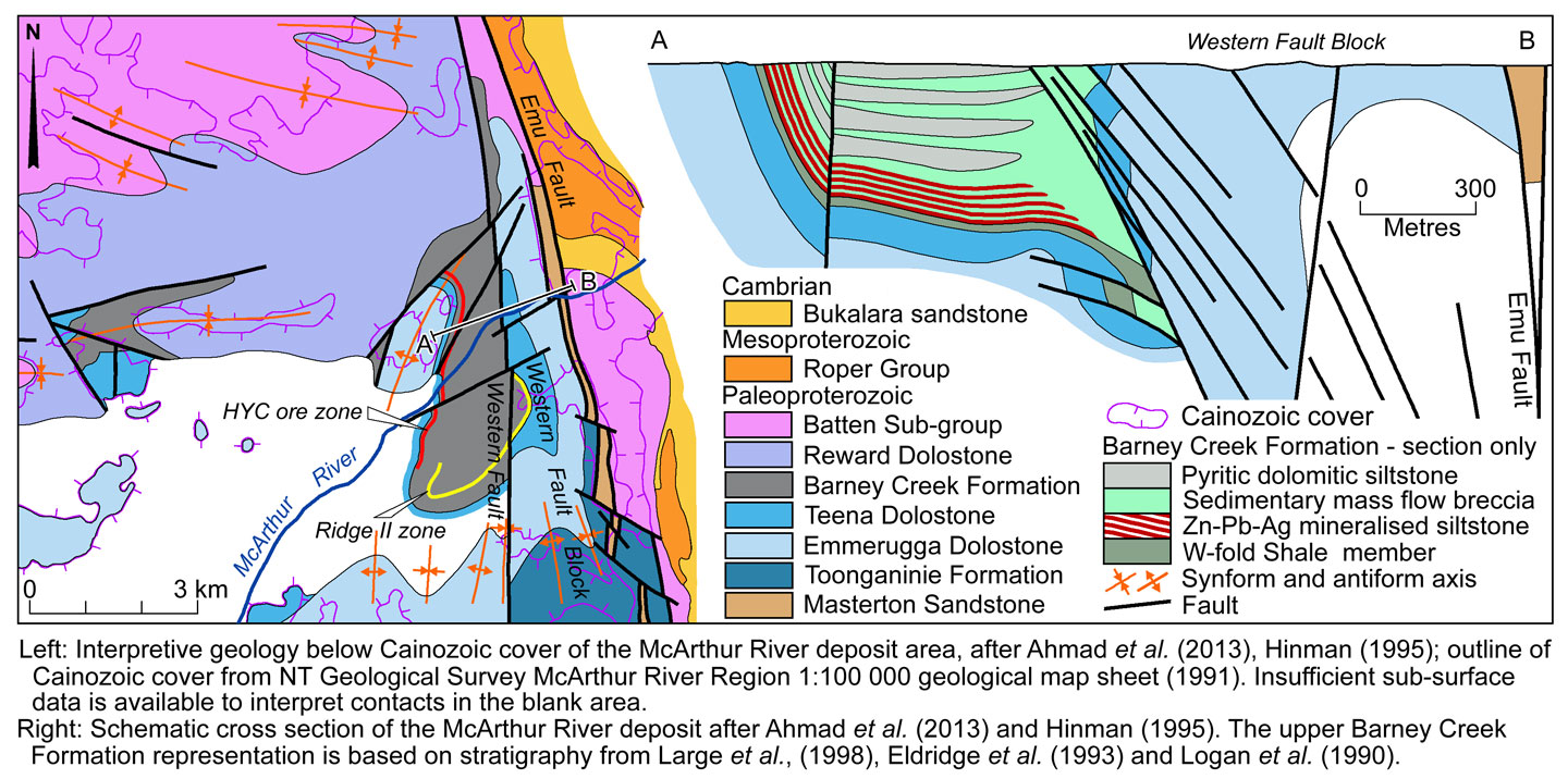
The McArthur River deposit is located immediately to the west of the major Emu Fault on the eastern margin of the Batten Fault Zone in the Southern McArthur Basin (Ahmad et al., 2013).
The sequence within the McArthur Basin is part of the broader Mt Isa-McArthur succession, which is, in turn, part of the Northern Australian Platform cover. This 5 to 15 km thick volcano-sedimentary pile was deposited during the period 1800 to 1580 Ma in an intracontinental setting. Deposition took place in three super-basins which represent three nested cycles of deposition and exhumation, specifically the Leichhardt (1798 to 1738 Ma), Calvert (1728 to 1680 Ma) and Isa (1667 to 1575 Ma) super-basins, terminated by the 1590 to 1500 Ma Isan Orogeny, which was followed by the fourth and younger, ~1500 to ~1400 Ma Roper super-basin (Jackson et al., 1999, 2000; Betts et al., 2003; Withnall and Cranfield, 2013; Stewart, GeoScience Australia 2015). Each of these super-basins corresponds to a period of extension, and each is ended by a basin inversion, although less intense inversions are also recorded within the duration of these super-basins, affecting the stratigraphic packages deposited within them.
All of the major stratabound Zn-Pb-Ag deposits of the Carpentaria Zinc Belt, including McArthur River, are hosted by 2 to 8 km thick successions of the Isa Superbasin, ranging in age from ~1660 to 1650 Ma (Dugald River, Lady Loretta), ~1650 Ma (Mt Isa), ~1640 (McArthur River) to 1595 Ma (Century; Queensland Department of Mines and Energy, 2000).
Rawlings et al. (1997) and Rawlings (1999) divided the McArthur Basin succession into five basin-wide depositional 'packages', each of which is disconformity or unconformity bounded and characterised by similarities in age, stratigraphic position, lithofacies composition, style and composition of volcanism, and basin-fill geometry across the McArthur Basin. These packages can be related to the super-basins of Jackson et al. (1999, 2000).
Within the Southern McArthur Basin, the packages, stratigrapic units and super-basins are as follows:
• Redbank package which comprises the Tawallah Group and corresponds to the Leichhardt and Calvert super-basins succession. The Tawallah Group unconformably overlies basement metamorphic rocks of the east-west trending Murphy tectonic ridge, with the Leichhardt super-basin largely not being represented. Maximum and minimum ages are constrained by the basement (Scrutton Volcanics: 1850 Ma; Pietsch et al., 1991) and overlying McArthur Group ~1660 to 1610 Ma; Munson, 2019).
The lower Tawallah Group comprises widespread fluvial to intertidal sandstones and conglomerates, and extensive flood basalts which were deposited between ~1790 and 1760 Ma (e.g., Yiyinti Sandstone, Westmoreland Conglomerate, Seigal Volcanics; Ahmad et al., 2013). These were succeeded between ~1760 and 1740 Ma by the middle Tawallah Group, composed of shallow marine, syn-extensional siliciclastic rocks overlain by post-extensional carbonate rocks (Ahmad et al., 2013) and a 1740 Ma mid-basin inversion that produced a regional unconformity at the base of the Wununmantyala Sandstone (Bull and Rogers, 1996). This unconformity and inversion event correspond to the boundary between the Leichhardt and Calvert super-basins (Blaikie and Kunzmann, 2020). Renewed extension from ~1730 to 1690 Ma produced widespread sedimentation and volcanism across the North Australian Craton. In the southern McArthur Basin, shallow marine to offshore siliciclastic rocks and minor carbonates of the upper Tawallah Group were deposited on an extensive low-relief platform, which included the Wollogorang Formation (Kunzmann et al., 2020), and the regionally extensive Settlement Creek Volcanics, which were predominantly emplaced as high-level sills, with the Gold Creek Volcanics inferred to be their eruptive equivalent (Ahmad et al., 2013; Rawlings, 2006). Available SHRIMP U-Pb zircon dates from upper Tawallah Group rocks near the centre of the succession range from 1708 to 1730 Ma (Page et al., 2000; Page and Sweet, 1998; Rawlings, 2002).
• Goyder package of the upper Calvert super-basin, which is largely absent from the Southern McArthur Basin, but may include some sandstones included in the upper Tawallah Group (Ahmad et al., 2013; Rawlings, 1999).
• Glyde package, which corresponds to the lower Isa super-basin. Within the Southern McArthur Basin, this package is represented by the McArthur Group that hosts the McArthur River deposit. In contrast to the unconformably underlying Tawallah Group, that is predominantly arenaceous, the up to 5 km thick McArthur Group comprises a succession of platformal stromatolitic dolostone and clastic sedimentary rocks with local pyritic and carbonaceous siltstone units (Winefield 1999). Deep seismic reflection data shows that in its central section, the McArthur Group gradually and systematically increases in thickness from ~1300 m to ~3200 m west to east respectively (Rawlings et al., 2004). Although exposures of the McArthur Group are confined to Batten Fault Zone, seismic data indicates that it continues at depth beyond the inferred limits of that fault zone (Rawlings et al., 2004). However, the one exception to the systematic westward thinning of the McArthur Group is around the Emu Fault, where the thickness appears to decrease to 2500 m immediately east of, and to >2700 m immediately west of the fault, whilst within the upward fanning flower structure of the Emu Fault, the thickness appears to locally increase to >3000 m.
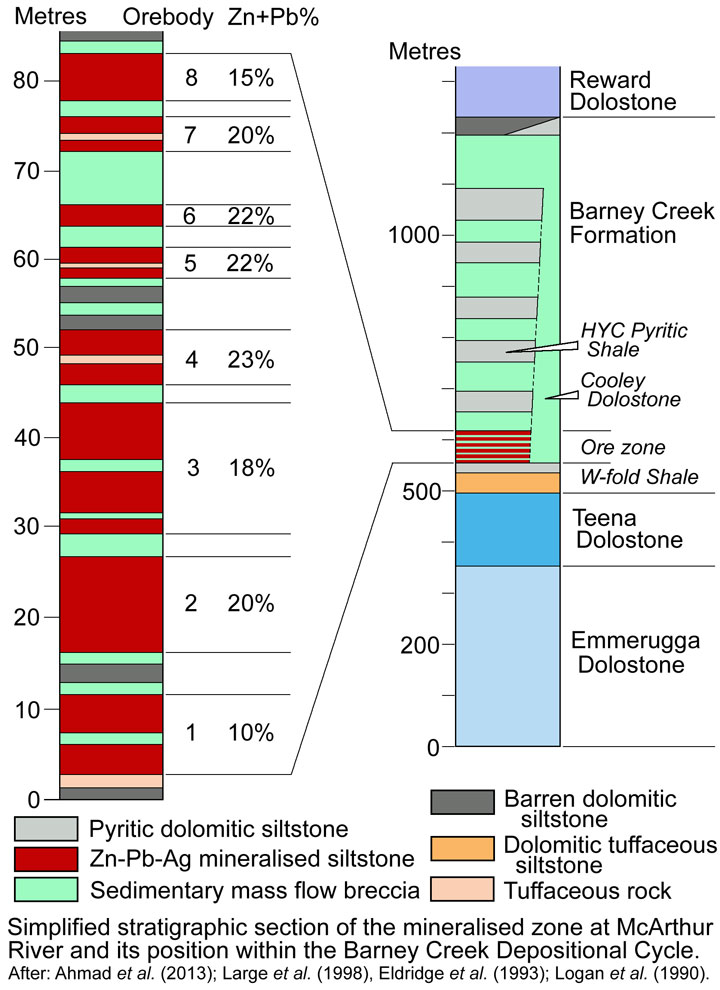
The McArthur Group is subdivided into the Umbolooga and overlying Batten subgroups, separated by a possible disconformity. The lower half of the Umbolooga Subgroup is characterised by alternating thick (200 to 650 m) units of sandstones, dolostones and dolomitic arenites. This succession fines upwards to dolostones and dololutites, including the 10 to 900 m thick, 1640±4 Ma Barney Creek Formation, composed of finely bedded to laminated, dolomitic, carbonaceous and pyritic siltstone, shale and dololutite, with locally abundant tuff beds and breccias, that hosts the McArthur River deposit within the HYC Pyritic Shale Member. This unit is underlain by the dololutites of the Teena Dolostone and is overlain by the uppermost unit of the Umbolooga Subgroup, the 30 to 350 m thick Reward Dolostone composed of dololutite, silty dololutite and lesser bedded to cross-bedded dolarenite. A local inversion and reactivation of faulting is recorded at ~1640 Ma, close to the time of deposition of the Barney Creek Formation and the McArthur River deposit. This event followed a longer interval of north-south directed extension and was succeeded by a return to extension. The overlying Batten Subgroup is largely composed of shallow marine to tidal and emergent dolostones, dololutite, dolomitic siltstones and lesser dolarenites, and a few beds of quartz sandstone. The uppermost unit of this subgroup has been dated at 1614±4 Ma (Ahmad et al., 2013).
• Favenc package, which corresponds to the upper Isa super-basin. Within the Southern McArthur Basin, this package is represented by the up to 1600 m thick Nathan Group. This sequence, which unconformably overlies the McArthur Group, was deposited in shallow marine to terrestrial setting, and comprises a relatively thin and lenticular basal siliciclastic and often conglomeratic unit, overlain by thicker carbonate and siliciclastic rocks containing tuff beds that have yielded a date of 1589±3 Ma. The Nathan Group includes the quartz arenite and dolarenite with cross-beds, ripple marks and commons gypsum and halite casts of the widespread, up to 700 m thick Karns Dolostone (Ahmad et al., 2013).
• Wilton package of the Roper super-basin, represented by the widespread Roper Group which covers an area of ~145 000 km2 and comprises an upward-coarsening cyclic succession of mainly marine mudstone alternating with sandstone, with minor micritic and intraclastic limestone, and ooidal ironstone (Ahmad et al., 2013).
District and deposit geology
Mineralisation at the McArthur River deposit is hosted by HYC Pyritic Shale Member lithofacies of the ~1640 Ma Barney Creek Formation, which occurs towards the top of the Umbolooga Sub-group of the McArthur Group. The immediate host sequence was deposited within a tectonically induced sub-basin that is bounded to the east by the major, north-south, syn-depositional, Emu Fault corridor, which lies on the eastern margin of the broader Batten Fault Zone.
The Emu Fault is a wide, generally NNW trending corridor of faulting, that is commonly 1 to 2 km wide, but is up to 5 km in width when the Western fault splay to the south of McArthur River is included. It has been interpreted, from deep seismic data, to be an upward fanning 'flower structure'-like zone of dislocation, including east dipping to vertical strike-slip, and west vergent reverse faults, representing repeated activity over a long period, prior to, during and after mineralisation at McArthur River. The overall fault zone has a steep west dip, with only minor net displacement of the McArthur Group, generally of <500 m. Strike-slip displacement on the Emu Fault prior to deposition of the Roper Group was most likely sinistral, including during deposition of the McArthur Group, whilst the youngest movement appears to have been dextral (Rawlings et al., 2004; Rogers, 1996; Hinman, 1995).
In contrast to the steep, overall strike-slip Emu Fault on the eastern margin of the broader Batten Fault Zone, the main, generally north-south structures toward the western margin, are east vergent thrust faults that post-date Roper River Group deposition and are splays off a deep detachment. The principal of these are the Tawallah and Scrutton faults that are ~35 to 50 and ~55 km to the west of the Emu Fault respectively. The sinuous Tawallah Fault merges with the Scrutton Fault to the south, and juxtaposes mainly Tawallah Group on the west/upper plate side over middle to upper McArthur Group to the east. In the north, the Tawallah Fault has an apparent 12 km of vertical displacement (Rawlings et al., 2004).
 The stratigraphy of the Umbolooga Sub-group, the lower of the two sub-groups that constitute the McArthur Group, may be summarised as follows, from the base (after Ahmad et al., 2013):
Masterton Sandstone, 40 to 650 m thick - a succession of fluvial to shallow marine, white, pink and red sandstone, minor mudstone and conglomerate that unconformably overlies various formations of the Tawallah Group.
Mallapunyah Formation, 100 to ~450 m thick - mudstone, siltstone, dolostone and sandstone, interpreted to have been deposited in a shallow-marine to sabkha environment, with pseudomorphs after halite and gypsum, and well developed diagnostic botryoidal quartz nodules (cauliflower chert).
Amelia Dolostone, 50 to 180 m thick - partly stromatolitic dolostone with local interbeds of dololutite containing diagenetic siderite.
Tatoola Sandstone, 80 to 350 m thick - comprising a lower, fine-grained, thinly bedded sandstone facies, deposited in a subtidal, deeper marine, storm-affected environment, and an upper, medium to coarse-grained, more thickly bedded sandstone and dolostone facies, interpreted to have been deposited in agitated shallow-water to intermittently emergent environment (Jackson et al., 1987).
Tooganinie Formation, ~200 m thick - a thick succession of dolostone and interbedded dolomitic sandstone, siltstone and shale.
Leila Sandstone, <10 to 30 m thick - shallow marine, fine to coarse-grained, dark grey weathering dolomitic sandstone with common cross bedding and ripple marks.
Myrtle Shale, 40 to 60 m thick - thinly bedded to laminated, lagoonal, commonly dolomitic siltstone, shale and fine-grained sandstone with common halite casts, and local stromatolitic dololutite.
Emmerugga Dolostone, 620 m thick - interpreted to have been deposited in a peritidal to deep marine environment on an extensive, relatively flat, intracratonic carbonate platform. It comprises a series of upward-shallowing cycles that deepen and thicken up-section (Winefield 1999), and has been subdivided into the:
- Mara Dolostone Member - that comprises shallow marine to sabkha environment silicified stromatolitic units, alternating with silty or non-stromatolitic units, comprising dololutite, dolomitic siltstone, dolarenite and dolomitic breccia.
- Mitchell Yard Dolostone Member - a non-stromatolitic, massive, grey featureless crystalline dolostone unit.
The package from the Myrtle Shale to Emmerugga Dolostone has been interpreted to represent a series of partly laterally equivalent and partly vertically distributed facies within what Winefield (1999) refers to as the Emmerugga Depositional Cycle, the first of three such cycles within the mid McArthur Group. They represent a phase of increasing accommodation within the host sub-basin, during which platformal carbonate lithofacies accumulated in a series of upward-shallowing cycles that thicken and deepen up-section, i.e., the deeper-water shale facies are regarded as being partially lateral equivalents of the shallow-water carbonate facies on the margins of the sub-basin (Winefield 1999).
Teena Dolostone, interpreted to have been deposited during basin subsidence, but infilled at a rate that resulted in upward shallowing to oolitic
and oncolitic grainstone, imbricated flat-plate breccias, ripple-marked mixed carbonate-siliciclastic rocks, finely laminated dololutite and thin interbeds of dolomitic shale, siltstone, dolarenite and rare thin beds of K-metasomatised mudstone. It has been subdivided into the:
- Lower Teena Dolostone, which is <60 m thick - thinly bedded to laminated dololutite, that is locally silicified, with dolomitic shale and sandstone, intraclast breccia and conglomerate, and dolarenite, deposited in a marine setting.
- Coxco Dolostone Member, 15 to 70 m thick - composed of grey crystalline dololutite with rare conical stromatolite, differentiated on the basis of its radiating, needle-like aragonite accumulations developed normal to bedding, variously interpreted to have pseudomorphs of sea-floor (Walker et al., 1977), sea-floor aragonite (Brown et al., 1978), lacustrine trona (Jackson et al., 1987), and an abiogenic aragonite sea-floor cement (Winefield 1999). The latter author suggested they were sea-floor cements generated by upwelling of HCO3-, Fe2+ and Mn2+-rich anoxic bottom water during rapid changes in basin bathymetry.
 The contact between the Teena Dolostone and overlying Barney Creek Formation varies from a sharp transition, to a zone of brecciation, fracturing and fissuring of the Coxco Dolostone Member just below the contact, with sedimentary infill of open space.
Barney Creek Formation, 10 to 900 m thick - a largely recessive unit composed of finely laminated to thinly bedded dolomitic, carbonaceous and pyritic siltstone, shale and dololutite, with locally abundant tuff beds and rare breccias. Jackson et al (1987) defined Three members, or more accurately lithofacies, have been defined. These area the:
- W-Fold Shale Member - which is composed of green and red dolomitic siltstone and shale, and green vitric tuff. Much of the siltstone has apparently been subjected to potassic alteration.
- HYC Pyritic Shale Member - a recessive, thinly bedded, laminated, carbonaceous (to bituminous), dolomitic pyritic siltstone, sedimentary breccias and tuffaceous mudstone. The siltstones are composed of quartz, potassium feldspar, albite, ferroan dolomite, calcite, chlorite, illite and kaolinite, and have an average grain size between 15 and 20 µm. The sedimentary breccias, which are fingers of the laterally equivalent Cooley Dolostone (see below) range from chaotic slump breccias to well graded silt beds. The tuffaceous mudstone beds are up to several metres thick, comprising quartz, potassium feldspar, albite, dolomite and calcite being the major constituents, and have yielded dates of 1640±4, 1639±3 and 1638±7 Ma (Logan et al., 1990; Page and Sweet 1998; Page et al., 2000; SHRIMP zircons from tuffaceous sediments).
- Cooley Dolostone Member - comprises one or more, locally-derived, overlapping, chaotic, fault-related intraformational slump breccias developed within the sub-basin on the western side of, and partially over, the uplifted Western Fault Block of the Emu Fault corridor. These breccias occupy the eastern fault controlled slope of the sub-basin and interfinger with the other lithofacies of the Barney Creek Depositional Cycle to the west. Clasts within these breccias range from millimetres to several tens of metres across, and were largely sourced from the Emmerugga and Teena dolostones (Pietsch et al., 1991) that are exposed in the uplifted Western Fault Block (Hinman, 1995). The matrix of these breccias grades from dolarenite to predominantly dolomitic mud where present in significant quantities. Pyritic and bituminous muds do occur occasionally, and are most prevalent to the west adjacent to the HYC Pyritic Dhale Member (Murray, 1975). These breccias and megabreccias are also locally found at the upper contact of the Coxco Dolostone Member.
There are three types of breccia, apparently related to the Cooley Dolostone Member lithofacies that interfinger with the HYC Pyritic Shale Member lithofacies (Walker et al., 1977). Type I breccias are the most abundant and are intimately related to the stratabound ores. These were apparently slumped into the sub-basin from the NNW from a very similar location and flow direction to the postulated ore fluids detailed later. Types II and III are localised in the upper stratigraphy of the Barney Creek Formation and are considered to have a different provenance and direction of movement into the sub-basin, with type II entering the basin from the SE (Walker et al., 1977). The type I sedimentary breccias and related dolomitic sediments are interpreted to be slump deposits and graded turbidites caused by deep seismic events and related movements along growth faults at the basin margin, including the NNW-SSE Emu Fault (e.g., Williams, 1978) or NW-SE to WSW-ESE trending faults to the north of the deposit (e.g., Walker et al., 1977; Logan, 1979).
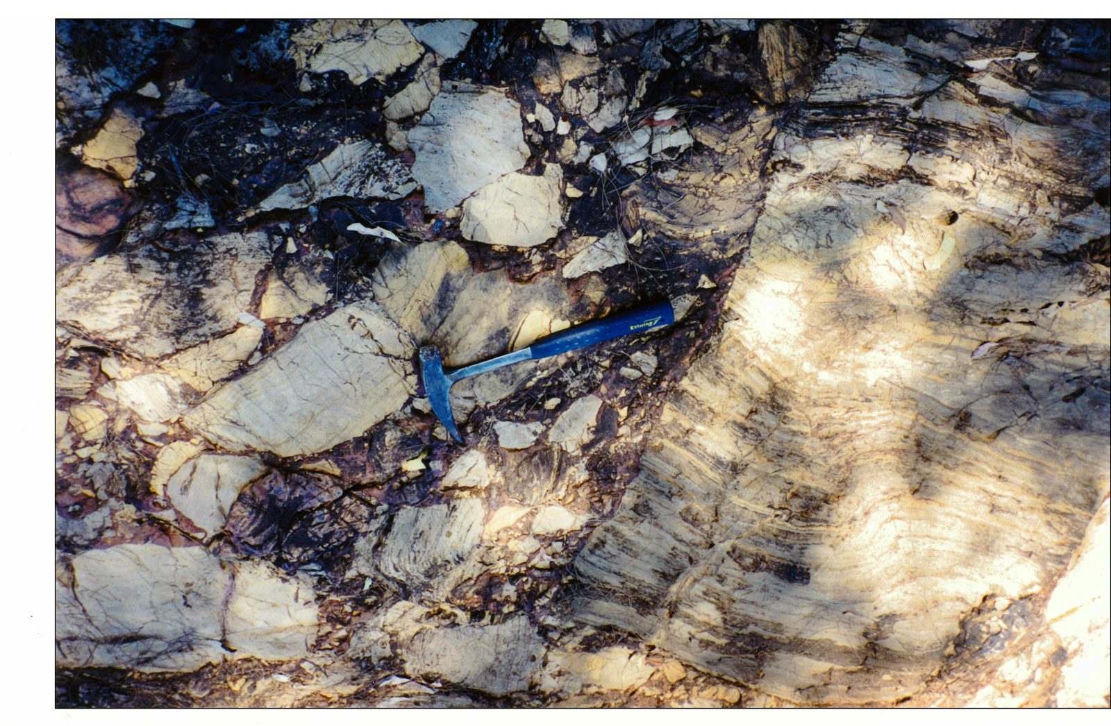 Intraformational slump/mass flow sedimentary breccia at the McArthur River deposit. Clasts of the Emmerugga and/or Teena dolostones, set in a matrix that grades from centimetre sized clasts to dolarenite and dolomitic mud. Image by Mike Porter, 1999.
Within the main depocentre of the sub-basin, the ~80 m interval of the Barney Creek Formation above the W-Fold Shale is predominantly composed of HYC Pyritic Shale, with intercalations of tuffaceous mudstone beds and breccias, as described above. In this interval a suite of eight 2 to 12 m thick HYC Pyritic Shale Member lenses host the main ore deposit, and are separated by 2 to 5 m thick beds of sedimentary breccia related to the Cooley Dolostone Member. Above this interval, the remainder of the Barney Creek Formation is occupied by more 'thickly' intercalated beds of black dolomitic siltstones of the HYC Pyritic Shale and mass flow breccias of the Cooley Dolostone, with individual bands of each being 40 to 80 m thick. The black 'shales' in this upper interval only contain low-tenor Zn-Pb mineralisation. The differences in thickness and distribution of these breccias and intercalated 'shales' may be related to a changed tectonic regime and nature of seismic activity that also resulted in different breccia styes (types II and III) found in the upper part of the sequence, their provenance and rate of deposition. Type II breccias are inferred to have been emplaced from the SE corner of the sub-basin with a flow direction towards the NW, emanating from near the Ridge II discordant carbonate hosted and stratabound mineralisation (Large et al., 1998; see the Ridge II description below).
Large et al. (1998) suggest that towards the close of the Barney Creek Formation deposition, the tectonic regime changed from extension to transpressive inversion (Hinman et al., 1994), with only minor iron-rich and reduced basinal brines contributed iron but only minor amounts of base metals into the sub-basin. They further suggest this inversion was accompanied by basin shallowing, and then deepening, corresponding to the concordant Ridge II Pb-Zn mineralisation, which is >300 m stratigraphically above the HYC ore, towards the top of the Barney Creek Formation (see the Ridge II description below), and finally, shoaling to the relatively shallow water Reward Dolomite facies (Bull, 1998).
Reward Dolostone, 30 to 350 m thick - comprising dololutite, silty dololutite, minor dolarenite, shale and local dolostone breccia, interpreted to have been deposited in an environment that ranged from peritidal, shallow subtidal to shallow open sea. The contact with the underlying Barney Creek Formation is generally conformable and gradational, although possible palaeo-regolith has been interpreted locally (Haines et al., 1993). The upper contact varies from being a transition from dolostone to siltstone and shale of the Caranbirini Member of the Lynott Formation, to disconformable where possible palaeoregolith is developed at the top of the Reward Dolostone (Haines et al., 1993, Pietsch et al., 1991).
The Barney Creek Formation has been interpreted by Bull (1998) and Winefield (1999) as predominantly a deeper-water shaly carbonate facies that
was deposited during maximum flooding related to a sea-level transgression. They suggest the carbonaceous pyritic shales are indicative of a quiet, anoxic, sub-wave base environment. These facies were deposited following an abrupt basinward shift at the top of the Emmerugga Depositional Cycle, marking the onset of tectonically-induced basin subsidence accompanied by what Winefield (1999) refers to as the Barney Creek Depositional Cycle. This latter cycle includes the Teena Dolstone, Barney Creek Formation and Reward Dolostone, interpreted to represent a series of partly laterally equivalent and partly vertically distributed facies, characterised by rapid lateral lithofacies variation. These lithofacies were deposited in numerous small sub-basins adjacent to reactivated, generally north-south trending faults (e.g., the Emu fault). According to Winefield (1999), facies architecture within the Barney Creek Depositional Cycle indicate that the thickest shale dominated facies appear to have been deposited and preserved adjacent to NNW to NW trending growth faults. Conversely, these lithofacies successions grade laterally into condensed sections adjacent to NNE to NE trending fault segments and laterally away from the thicker sub-basins.
Winefield (1999) suggests this facies architecture is consistent with differential strike-slip movement along sinuous, generally north-south faults producing transtensional sub-basins adjacent to NNW to NW fault segments, and transpressive sub-basins or platform margins along NNE to NE trending fault sections.
Adjacent to these sub-basin margins, gravitationally unstable slopes developed, characterised by coarse-grained clastic slope lithofacies and abundant slope-related deformation which include sediment (neptunian) dykes, liquifaction breccias, megabreccias and soft-sediment slump folds (Winefield 1999). The chaotic intraformational breccias of the Cooley Dolostone Member, which are developed along section of the Emu Fault and interfingers with the HYC Pyritic Shale Member away from the fault, represents one of the best examples of these slope lithofacies, as described above.
The Umbolooga Sub-group is overlain by the Batten Sub-group, above an implied disconformity, as indicated by the interpreted partial palaeo-regolith described above. The lower units immediately following the Barney Creek Depositional Cycle are the:
Lynott Formation, 50 to 600 m thick - an evaporite-rich unit, mainly composed of dolomitic siltstone, dolarenite, stromatolitic dolostone and
lesser dolomitic sandstone, split into three conformable members (Jackson et al., 1987), the:
- Caranbirini Member, 0 to 400 m thick - thinly bedded, laminated fine-grained mudstone and dolomitic mudstone, which is locally a carbonaceous and/or pyritic, dololutite, with intraclast breccia and pink tuffaceous mudstone.
- Hot Spring Member, 50 to 350 m thick - which is typically and mostly composed of dolomitic siltstone, silty dololutite and sandstone, with ubiquitous evaporite pseudomorphs, suggesting deposition on intratidal to supratidal flats (Pietsch et al., 1991).
- Donnegan Member, 0 to 134 m thick - thinly to medium bedded, commonly rippled and cross-bedded red-brown to buff dolomitic siltstone and sandstone, with lesser dolarenite and thin to medium beds of chert altered stromatolitic dolostone. It is characterised by abundant small botryoidal quartz nodules, cauliflower and enterolithic chert, considered to be consistent with deposition in a supratidal to sabkha environment. Dating of a tuff band near the top of the member returned a date of 1636±4 Ma, within error of the Barney Creek Formation (Page et al., 2000).
Yalco Formation, <50 to 250 m thick - which conformably overlies the Donnegan Member and includes silicified, thinly bedded and interbedded, stromatolitic dololutite, silty dololutite, dolarenite and dolomitic sandstone, containing abundant intraclast chert breccias, laminae and nodules. Ripple marks, desiccation cracks, tepee structures and casts and moulds after evaporite minerals are evident, suggesting deposition in a shallow-marine environment that was subjected to periodic emergence.
The Lynott Depositional Cycle, which extends from the Caranbirini Member to the top of the Yalco Formation, overlies the Barney Creek Depositional Cycle and is interpreted to represent a phase of renewed basin subsidence. According to Winefield (1999), the spatial distribution of the lithofacies of this new cycle is distinctly different to that of the previous, suggesting a subtle but important shift in the controlling structures.
Stretton Sandstone, <55 to 270 m thick - which conformably overlies the Lynott Depositional Cycle, and comprises a 1625±2 Ma sequence of thinly bedded, shallow marine to sub-wave base quartz arenites.
Looking Glass Formation, 30 to 70 m thick - silicified, peritidal to shallow marine stromatolitic dolostone and dolarenite.
Amos Formation, <70 m thick - which marks the top of the sub-group, composed of siltstone, sandstone and crystalline dolostone, representing red beds and palaeo-calcrete, dated at 1614±4 Ma.
Mineralisation and alteration
The McArthur River mineralisation is hosted within fine grained HYC Pyritic Shale Member lithofacies, and comprises 8 individual ore lenses that are from <2 to >12 m thick, each of which is separated by <2 to 5 m thick bands of interfingering Cooley Dolostone type sedimentary breccia, and lesser poorly bedded or fragmented pyritic and dolomitic shale interbeds. The deposit covers an area of ~2 km2, and has an average composite thickness of 55 m. Its eastern margin is ~1.5 km west of the main Emu Fault, separated by the Cooley Dolostone breccia lithofacies and the Western Fault block, an up-faulted horst of sedimentary rocks older than the HYC Pyritic Shale Member within the broader Emu Fault corridor (Ahmad et al., 2013; Ireland et al., 2004; Logan et al., 1990). The western margin of the deposit has been folded and eroded. The northern margin interfingers with sedimentary slump breccia derived from older McArthur Group sediments to the north of the deposit, while the southern boundary is gradational into barren pyritic siltstone of the condensed Barney Creek Depositional Cycle (Walker et al., 1977).
The stratabound ore lenses are characterised by regular, fine-grained bands of sphalerite and galena interlayered with beds of dark bituminous and tuffaceous shale on both the macro- and micro-scales (Croxford and Jephcott, 1972). The sulphide layers comprise a complex mixture, rather than mono-minerallic bands (Eldridge et al., 1993), although many of the metal sulphide rich bands are dominated by sphalerite and/or galena (Large et al., 1998).
Whilst there are many different textural and compositional variations within these ore lenses, Large et al. (1998) recognised three end-member microband types:
• organic-rich mud layers, that are commonly <500 µm thick, are principally composed of illite, carbonaceous matter, pyrite and quartz, and are interpreted to be the product of normal pelagic sedimentation from the anoxic water column.
• quartz-illite-carbonate silt layers, which are usually 100 to 500 µm thick, although laminae up to several cm thick are also present. These thicker bands are normally graded, consistent with deposition by mass flow. Croxford and Jephcott (1972) regarded these bands to be turbidites.
• zinc-lead sulphide-rich layers, that are normally 200 to 500 µm thick and composed of uniform mixtures of sphalerite-galena±pyrite with lesser ankerite, quartz and minor chalcopyrite and arsenopyrite. Sphalerite is the dominant sulphide mineral, with sphalerite:galena ratio of from 2:1 to 12:1, based on observations of samples from ore lens 2.
Whilst it is common for the three end-member microband types to be regularly interlayered, mixtures of these end members may also occur, e.g., layers composed of a mixture of organic muds and zinc-lead sulphides or zinc-lead sulphides and quartz-carbonate silts (Large et al., 1998).
Major sulphides Two generations of pyrite have been identified. The earlier, Py1 comprises >80% of the pyrite at McArthur River and is present as 1 to 15 µm sized euhedral to subhedral, octahedral and cubic crystals, and as both loosely packed spherical framboids and tightly packed round to ellipsoidal macroframboids (Croxford and Jephcott, 1972). Py1 is a minor component of the entire deep-water facies of the Barney Creek Formation, but is abundant (5 to 60 vol.%) in and around the main McArthur River deposit.
Py1 is overgrown by Py2, which also occurs interstitially to the earlier pyrite crystals/spherules (Rye, 1974; Williams, 1978; Large et al., 1998) and is composed of fine to coarse (10 µm to 1 mm) anhedral to subhedral crystals, crystal aggregates and blebs, as well as the Py1 overgrowths. SHRIMP ion microprobe determinations of the sulphur isotope compositions of pyrite from the ore lenses has produced δ34S values for Py1 and Py2 that range from -13 to +15 and -5 to +45‰ respectively (Eldridge et al., 1993). This was interpreted by the same authors to indicate growth of pyrite likely involved H2S formed by biogenic processes. On average, the δ34S values of Py2 are about 15‰ higher than those of Py1, suggesting that the pyrite types may have formed sequentially from a single batch of sulphate in an environment which became closed with respect to sulphate supply through time. This has been taken to indicate an early biogenic diagenetic Py1 derived from sea water sulphate, and a later deeper diagenetic pyrite without direct access to sea water, only sulphate trapped in the host sediment (Eldridge et al., 1993).
The occurrence of pyrite and zinc-lead sulphides differs, in that pyrite does not form discrete continuous layers, as do the zinc-lead and sediment bands, but instead occurs as patchy disseminations. Fine grained pyrite is disseminated in most, but not all, zinc-lead layers, within organic mud bands, or rarely, as discontinuous layers within quartz-carbonate silt bands. The more prominent coarse-grained pyrite, comprising irregular masses from 100 µm to >1 mm across, is common, erratically distributed within either the organic-rich mud layers or the zinc-lead bearing bands (Large et al., 1998).
Sphalerite occurs as near monominerallic layers up to 1 mm thick, as elongate accumulations up to 0.2 mm in diameter, and as fine grained disseminations, whilst galena is also observed as near monominerallic layers up to 0.05 mm thick, as streaks in sphalerite layers and as fine-grained disseminations. Chalcopyrite is present as minute elongate inclusions in sphalerite (Ahmad et al., 2013).
The differences between pyrite and base metals sulphides are also reflected by conventional sulphur isotope analyses of sulphide separates, which indicated that δ34S values of pyrite (Py1 + Py2) increase from -3.9 to 14.3‰ from the footwall to hanging wall, whereas those of galena and sphalerite are constant at -1.2 to +5.7 and 3.3 to 8.9‰, respectively (Smith and Croxford 1973). These data are supported by Eldridge et al. (1993) who found that δ34S for base metal sulphides (sphalerite, galena and chalcopyrite) is restricted to a range from -5 to +14‰ and excluding the few late-stage veins, is further limited to a range of -5 to +8‰. Eldridge et al. (1993) interpreted these data to suggest the formation of the base metal sulphides was distinct from that of Py1 and Py2 precipitation, and that localisation of the base metal sulphides did not involve biogenic sulphide either directly through use of residual microbially generated H2S(aq.) or by replacement of Py1 or Py2. Eldridge et al. (1993) noted that while the ratio of Py1:Py2 fluctuates considerably, the temporal relationship is invariant, and the author's had not observed either pyrite type to have nucleated on, or to have overgrown, sphalerite or galena. These mutual textural and isotopic relationships they interpreted to suggest a paragenetic sequence at any one point or bed in the deposit, in which Py1 was followed by Py2, with galena and sphalerite forming later than pyrite (Eldridge et al., 1993; Ahmad et al., 2013).
However, Ireland et al. (2004) observe that Py2 nucleates in, permeates,
and locally expands sphalerite rich laminae with associated recrystallisation of sphalerite to monominerallic aggregates free of inclusions (Large et al., 1998). It also displaces or overprints all other minerals associated with mineralisation at McArthur River and hence Ireland et al. (2004) consider it to be the latest sulphide phase in the paragenetic sequence.
Eldridge et al. (1993) interpreted three modes of sphalerite-galena occurrence within the ore lenses:
• Mode 1 - fine-grained zinc-lead bands of sphalerite-galena distributed parallel to bedding. This mode constitutes >80% of the sphalerite-galena in the ore lenses. EIdridge et al. (1993) interpreted this sphalerite-galena to have formed as a grain cement within siltstone layers, enclosing many non-sulphide grains, initially by pore-space filling, but eventually leading to total replacement of the siltstone layers. Large et al. (1998) observe that these sulphide bands are intricately interlayered with, and have sharp conformable boundaries with both pelagic mudstone beds and quartz-carbonate turbidites. If the sphalerite-galena bands were purely replacive, the more reactive quartz-carbonate turbidite bands would be expected to be preferentially replaced, or at least have gradational boundaries with adjacent zinc-lead sulphide layers. They also point out that clasts within turbidite layers overlying sphalerite-galena bands cause compaction load features, while flame structures composed of sphalerite-galena extend up into overlying mass flow units indicating the presence of those sulphide bands before the turbidite introduction. In addition, the coarser sphalerite-galena bands contain physically rounded and subrounded clasts of base metal sulphides and pyrite, while layers composed of base metal sulphide microbreccias are common, comprising rounded to angular clasts of base metal sulphides in a matrix of mixed sediment and disseminated sulphides. Banded base metal sulphide clasts, from 1 to 70 cm across, have been observed in the inter-ore breccias (e.g., Croxford, 1968; Croxford and Jephcott, 1972; Scott and Lambert, 1979; Williams, 1979; Coutts, 1996), texturally identical to the banded zinc-lead sulphide ores, and these clasts appear to have undergone soft sediment deformation during incorporation into the breccia beds. Large et al. (1998) argue all of these observations suggest sphalerite-galena precipitation was either syn-depositional, or very early diagenetic, during deposition.
Sphalerite within Mode 1 sulphide bands, Sp1 of Ireland et al. (2004), is a very fine grained (1 to 10 µm) cryptocrystalline variety occurring as irregular, elongate and blebby 2 to 200 µm thick aggregates that coalesce to define sphalerite-dominated laminae that are 0.2 to 1 mm thick within carbonaceous siltstone. This sphalerite is characteristically associated with euhedral 100 to 500 µm ankerite crystals and euhedral 10 to 200 µm quartz crystals, and at a microscopic scale, bands of this sphalerite contain silt clasts, organic matter and other gangue minerals. Sp1 bands may include up to 50 vol.% Py1, and may coexist with and locally contain up to 50% euhedral quartz and ankerite crystals, but is commonly zoned from quartz-ankerite bearing Sp1 at the base, to quartz-ankerite poor varieties with abundant enclosed Py1 at the top. Laminations of Sp1 are locally
disrupted by nodular carbonate developments and Py2 aggregates, suggesting Sp1 is a paragenetically early phase. The intimate relationships between Sp1, ankerite, and/or quartz and Py1 are considered by Ireland et al. (2004) to indicate co-deposition of these minerals, with quartz and ankerite forming immediately after the deposition of each Sp1 lamination.
Zinc-lead sulphides have been considered by most authors to post date pyrite (e.g., Williams, 1978; Eldridge et al., 1993; Large et al., 1998), because Py1 occurs as inclusions in all other minerals related to mineralisation. However, Ireland et al. (2004) note there is a consistent and complex relationship between Py1 and Sp1, which they imply, suggests that the formation of these minerals was contemporaneous.
Laminated early Sp1 has a δ34S values that range from 02.41 to ~12.1, and a mean of 3.8‰, zoned from 4 to 6 in the centre of the deposit, to 0 to 3‰ on the extreme lateral fringes to the north and south.
• Mode 2 coarser grained, patchy sphalerite-galena, intergrown with carbonate nodules, and within nodular carbonate layers (Eldridge et al., 1993; Large et al., 1998). Sphalerite associated with mode 2 zinc-lead sulphides, Sp2, comprises 15 to 20% of all sphalerite at McArthur River, and may locally constitute up to 100% of the sphalerite in zones of abundant carbonate nodules. It comprises 1 to 10 mm crystalline aggregates that are associated with nodular, micritic or clastic carbonate, and usually occurs as variable replacement of sparry to micritic carbonate aggregates that are 0.5 to 4 mm thick. According to Ireland et al. (2004), Sp2 was formed late in the paragenetic sequence, following carbonate nodules that displace Sp1 bands, but are overprinted by Py2. These carbonate nodules and clasts usually have a rim of Sp2 and retain a core of carbonate, although they may locally be completely replaced or have internal textures selectively replaced by Sp2. Sp2 domains are usually virtually monominerallic with regard to sphalerite and devoid of inclusions, other than Py1, precursor carbonate and very rare euhedral quartz and ankerite. Sp2 and diffuse Sp1 that occur in adjacent laminae retain their textural differences and are both overprinted by Py2 (Ireland et al., 2004). Large et al. (1998) suggest this mineralisation is the result of replacement during diagenesis and recrystallisation associated with dolomite nodule growth in the presence of Zn-Pb saturated sediment pore fluids.
The δ34S values of Sp2 have a mean of 9.8‰ (ranging from 3.2 to 18.6), 6‰ greater than the deposit wide mean value for Sp1. These data represent a discrete population and are not a subset of the Sp1 δ34S population. Analyses of pairs of closely adjacent Sp1 and Sp2 samples, including in adjacent laminae, indicate that, despite the overlap of populations, δ34S values for Sp2 are consistently higher than those for Sp1.
• Mode 3 coarse-grained sphalerite-galena-chalcopyrite, occurring in discrete patches is considered to mainly have a clastic origin, being introduced during turbidite sedimentation (Large et al., 1998). These sulphides occur as rounded and subrounded base metal and pyrite clasts that are commonly found within the thicker graded turbidite beds with thicknesses of >1 cm. The rounded base metal sulphide clasts are interpreted to have been reworked from earlier formed sulphide layers on the sub-basin margin/floor and possibly by the erosion of chalcopyrite-rich vein-style mineralisation (similar to that at the Cooley deposit) from the faulted margins of the basin (Large et al., 1998). Others may have formed by the near-complete replacement of isolated carbonate nodules (Eldridge et al., 1993; Large et al., 1998). This mode of mineralisation is volumetrically insignificant (Large et al., 1998).
Other sulphides include galena, arsenopyrite and chalcopyrite which occur throughout the deposit. Galena is commonly found as very fine grained intergrowths in Sp1 laminations, whilst chalcopyrite is occurs as fine intergrowths within some sphalerite-galena laminations and also as coarser aggregates replacing carbonate clasts in siltstone bands. Both are found in crosscutting deformation-related fractures. Arsenopyrite is very rare and occurs as euhedral prisms in micritic nodular, and brecciated carbonate (Ireland et al., 2004).
Alteration - The McArthur River orebody is surrounded by well developed alteration envelope composed of the following elements (Lambert and Scott, 1973; and Large et al., 2000):
• A Zn-Pb-Tl halo surrounds the deposit, characterised by values of >1000 ppm Zn, >100 ppm Pb and >4 ppm Tl, extending for up to 250 m into the hanging wall lithologies, up to 50 m into the footwall, and up to 15 km SW along the favourable pyritic siltstone host-rock facies of the condensed Barney Creek Depositional Cycle.
• A manganoan carbonate halo that is confined to the W-Fold Shale Member lithofacies that occurs immediately below the host HYC Pyritic Shale Member lithofacies, forming the most laterally extensive part of the composite HYC alteration system. The average MnO content of dolomite within the W-Fold shale increases systematically towards the deposit over a distance of at least 23 km from SW to NE (Large et al., 1998). According to Winefield (1999), rapid basin subsidence at th eclose of Teena Dolostone deposition, accompanied by deepening of the sub-basin and increasing water depth resulted in upwelling of HCO3-, Fe2+ and Mn2+-rich anoxic bottom water. This resulted in Mn concentration deposited at the oxic/anoxic boundary transition below the developing margins of the sub-basin, forming an extensive Mn-halo in the footwall and along strike from the HYC mineralisation (Large et al., 1998).
• A ferroan dolomite-ankerite halo that is represented by a narrow zone of manganese-rich ferroan dolomite surrounding the deposit and persisting for ~23 km to the west, generally coextensively with the Zn-Pb-Tl envelope. The molar Fe/Mg ratio content of the dolomite which is generally >0.1, increases systematically toward the orebody footwall contact, both along and across strike (Large et al., 2000). Ankerite with pyrite accompanied deposition in the deepest water of the sub-basin at several hundred metres water depth (Large et al., 1998).
• An extensive C-O isotope halo within the dolomitic siltstones of the Barney Creek Depositional Cycle which extends for at least 15 km SW of the McArthur River deposit and approximately coincides with a the lithogeochemical halo of elevated Fe-Mn-Zn-Pb and Tl. Dolomite within this halo has an 18O enriched and 13C depleted isotope signature (δ18O = 23 to 26‰ SMOW, δ13C = -2 to -3.5‰ PDB), relative to normal Proterozoic sedimentary dolomite beyond the halo (δ18O = 20 to 23‰ and δ13C = 0 to -2‰). Dolomitic siltstone lamellae within the Zn-Pb-Ag ores have an isotopic range similar to that of the halo dolomites, suggesting the ore and halo equilibrated from the same hydrothermal fluid. Modelling of isotopic exchange associated with fluid-rock interaction suggests that the halo dolomites equilibrated with low-temperature fluids (50 to 120°C), which were enriched in 18O (δ18O = 5±5‰) but with an average crustal carbon isotope signature where δ13C = -6±1‰ (Large et al., 2001).
These four halos described above occur on the south, southwest, northwest and northern fringes of the deposit and are considered to be related to the release of cool Fe- and Mn-bearing brines into developing sedimentary basins, both prior to and subsequent to the Zn-Pb mineralising episode (Large and McGoldrick 1998). Large et al. (2001) estimate that the brine pool temperatures were highest at 40 to 70°C in and adjacent to the McArthur River deposit, decreasing to values of 17 to 30°C remote from the deposit.
The chemistry of the primary hydrothermal fluids responsible for this alteration and accompanying mineralisation, prior to their release into the brine pool, has been constrained by isotopic and thermodynamic modelling to be mildly acid to near-neutral with temperatures of 100 to 240°C, salinity of ~25 wt.% NaClequiv. and Zn-Pb concentrations below sphalerite and galena saturation (Rye and Williams, 1981; Cooke et al., 2000; Large et al., 2001).
• Hydrocarbons that are diagnostic of systems in which organic matter is rapidly heated during the passage of hot water through sediments, in particular higher temperature transported polycyclic aromatic hydrocarbons (PAHs), were differentially deposited in higher concentrations within ore bearing beds, and are positively correlated with base metal abundance. In contrast, less permeable beds, e.g., mudstones within centimetres to tens of centimetres above, below or within the ore lenses, carry a higher proportion of overprinted hydrocarbons interpreted to have formed during low-temperature diagenesis or normal in situ burial maturation (Chen et al., 2003).
These high temperature aromatic hydrocarbons have not been encountered at other locations in the McArthur Basin, away from the orebodies.
Experimental data indicate the hydrothermally generated PAHs form at temperatures of between 250 and 400°C (Simoneit, pers. comm., 2001 reported in Chen et al., 2003), higher than the estimates of Large et al. (2001) and other authors detailed above. These hydrocarbons are distributed over a length of >2 km, and to maintain these temperatures would require insulation from cool sea water by at least 10 to 20 m of sediment below the sea floor. Chen et al. (2003) envisage brine flow to have been largely parallel to bedding, concentrated in the silty layers because of rapid loss of permeability in the enclosing muddy units during shallow burial. This suggest that channeling of hot fluids along permeable horizons led to the interaction with organic matter and sulphates within the silty turbidites. Ore-forming reactions would produce acid that, in turn, would have generated additional porosity through carbonate dissolution. Examination of ultrathin sections from PAH rich siltstone units indicates loss of dolomite and formation of micro-stylolites in the ore zones, and re-deposition of Fe- and Mn-enriched nodular carbonates downstream.
As the brines carrying PAHs cooled and the solubility of the PAHs dropped, they were precipitated from solution in order of their molecular weight. The resultant pattern of distribution of PAHs is consistent with the existence of a large thermal gradient that suggests the PAHs were generated upstream to the NNE and moved laterally to the SSW with the mineralising brine, cooling as they went, passing from high to lower grade sulphide accumulations to distal zones of nodular carbonates (Chen et al., 2003). The same authors envisage a proportion of these brines escaped across the stratigraphy to the surface and formed pyrite by thermochemical sulphate reduction in the hotter zones, but most likely by bacterial sulphate reduction in cooler zones closer to the sea floor, accompanied by 'nodular carbonate' and carbonate 'crusts', and silica gel at the sediment-water interface.
Conclusions - Large et al. (2001) and Ireland et al. (2004) and previous authors they draw from, mount a convincing argument that much of the pyrite-sphalerite-galena within the McArthur River deposit, particularly Py1 and Sp1, was emplaced at the sediment water interface from a stratified brine pool developed in the deepest part of a fault controlled sub-basin adjacent to the Emu fault corridor. Hydrothermal fluid are postulated to enter the lower brine pool as a series of pulses related to seismic activity along the feeder fault systems (Large et al., 1998). This seismic activity was responsible for initiating mass flow turbidites and breccias and for pumping hydrothermal fluids into the sub-basin. Each new pulse of brine has a similar salinity but higher temperature (120 to 240°C, Rye and Williams, 1981) than the cooled waters in the lower brine pool, and consequently rose rapidly to the top of water column, before beginning to cool and follow a convective path downward. As each new pulse of hydrothermal fluid cooled, it would sink and mix with the lower brine pool fluids and precipitate sphalerite, galena and pyrite to be mixed with subwave base sedimentation of mass flow clastic carbonates and pelagic organic-rich fines to form the laminated sedimentary ores (Large et al., 2001).
Large et al. (1998) suggest that, on average, more than 10 000 pulses of dense fluid were released to generate the intricate layering of base metal sulphides and sediment layers common to each ore lens. Ireland et al. (2004) suggest that each new pulse resulted in a layer of Sp1 and Py1 and that entrapped pore fluids, due to permeation into the underlying sediment, resulted in the diagenetic overprinting by replacement Sp2 and Py2. They argue that rather than a paragenetic sequence that relates to the entire deposit, each new pulse produced its own paragenetic sequence on a laminae/bed scale of Sp1/galena and Py1 → nodular carbonate, followed by subsurface diagenetic Sp2 and Py2 replacement, to be repeated by multiple pulses. This would account for the textural complexity and isotopic disequilibrium between sulphide phases. Possibly the Sp1 and Py1 crystallised from different levels in the stratified brine pool column where different δ34S levels were stable, to settle together on the sea floor, but have different S compositions.
Chen et al. (2003) also put forward a convincing argument for shallow replacement by higher temperature hydrothermal fluids as described above. Possibly both processes were represented, with those fluids that were released into the sea and brine pool accounting for the bulk of the Sp1 and Py1, while brine from the same source was also transmitted along permeable strata in the 'soggy' sediment pile below the sub-basin floor to overprint earlier stratabound sulphide accumulations to produce Sp2 and Py2 by replacement and/or remobilisation.
Reserves, resources and production
The total geological resources prior to mining - 227 Mt @ 9.2% Zn, 4.1% Pb, 41 g/t Ag, 0.2% Cu (Logan et al., 1990).
Reserves and resources as of mid 2004 (Xstrata Zinc) totalled:
Proven reserve - 5.2 Mt @ 31.0% Zn, 5.3% Pb, 53 g/t Ag,
Probable reserve - 26.0 Mt @ 11.0% Zn, 5.1% Pb, 53 g/t Ag
Measured resource - 80.0 Mt @ 13.0% Zn, 5.8% Pb, 57 g/t Ag,
Indicated resource - 41.0 Mt @ 12.0% Zn, 5.5% Pb, 57 g/t Ag,
Inferred resource - 0.7 Mt @ 17% Zn, 5% Pb, 60 g/t Ag.
Production from McArthur River in the 12 months to June 2004 totalled - 1.59 Mt @ 13.1% Zn, 5.6% Pb, 55 g/t Ag, representing the final stages of the underground mine before commencement of the open pit operation in 2005.
According to Ahmad et al. (2013), ore reserves and mineral resources at McArthur River at 30 June 2007 were:
Total reserves - 46.3 Mt @ 9.6% Zn, 4.2% Pb, 43 g/t Ag;
Total resources - 144 Mt @ 11.2% Zn, 4.8% Pb, 48 g/t Ag.
Remaining JORC compliant ore reserves and mineral resources as at 31 December, 2016 (Glencore, 2017) were:
Ore reserves
Proved reserve - 71.2 Mt @ 10.6% Zn, 5.00% Pb, 50.1 g/t Ag;
Probable reserve - 45.0 Mt @ 7.4% Zn, 3.6% Pb, 37 g/t Ag;
Total reserve - 117.0 Mt @ 9.4% Zn, 4.5% Pb, 45 g/t Ag.
Mineral resources which are inclusive of reserves
Measured resource -123 Mt @ 9.94% Zn, 4.64% Pb, 46.9 g/t Ag;
Indicated resource - 64 Mt @ 8.9% Zn, 4.1% Pb, 43 g/t Ag;
Measured + indicated resource - 190 Mt @ 9.6% Zn, 4.5% Pb, 46 g/t Ag;
Inferred resource - none reported.
The current mine capacity is 5 Mt of ore per annum.
The McArthur River operation is owned by McArthur River Mining, a subsidiary of Glencore.
Other related deposits/mineralisation
A number of other deposits and occurrences, both stratabound within the Barney Creek Depositional Cycle and transgressive within other lithologies are known within a 20 km radius to the south and west of McArthur River, including:
Teena
This deposit is located 8 m west of the McArthur River zinc-lead mine, and occurs within the east-west elongated Teena sub-basin, a half-graben that is bounded to the north by the ENE-WSW trending growth structure, the Jabiru Fault. Mineralisation is hosted within rocks interpreted to equate with the Barney Creek Formation. The Barney Creek Formation rests on the Teena Dolostone, and is thickest adjacent to, and to the south of, the Jabiru Fault, thinning to the south. The sequence comprises the basal W-Fold Shale Member, overlain progressively by the HYC Shale Member which hosts the ore deposit, Pyritic Barney Creek Formation and the Upper Barney Creek Formation, which transgresses the sequence to the south to rest directly on the Teena Dolostone by ~1 km south of the Jabiru Fault. The Reward Dolostone and Caranbirini Formation overlie the Barney Creek Formation. To the north of the Jabiru Fault, Rox Resources sections show the Upper Barney Creek Formation resting directly on the Teena Dolostone. Those same sections indicate south down displacement on the fault of ~250 to 300 m.
The deposit is concealed, being shallowest to the west at depths of ~500 m, deepening to be at ~1000 m depth, ~1300 m to the east. It extends for ~400 to 300 m outward from the Jabiru Fault, narrowing to the east.
The zinc-lead mineralisation at the Teena deposit is interpreted to have been precipitated as stratabound sulphide minerals within fine grained carbonaceous sediments that were accumulating at the base of an anoxic brine pool during sub-basin development, similar to those described above at the McArthur River mine. At a mesoscopic scale, the mineralisation occurs as bedded massive sulphides intercalated with carbonaceous shales and calcareous siltstones. Several phases of mineralisation have been observed ranging from near-syngenetic depositional, to late stage hot influx events during diagenesis and remobilisation and replacement during basin inversion. In the mineralised lodes the principal sulphide minerals (in abundance order) are sphalerite, pyrite, pyrrhotite and galena along with trace arsenopyrite. The main gangue minerals are silicates (orthoclase, quartz and muscovite), ankerite and traces of barite.
Zinc-lead mineralisation occurs as two sub-parallel, conformable lenses, known as the Lower and the Upper Lodes. The Upper Lode is thicker (up to ~30 m) and higher grade than the Lower (up to 10 m thick). At a 6% Zn+Pb cut-off grade, the JORC compliant inferred mineral resources for each lode are estimated to be, Upper Lode - 45 Mt @ 12.0% Zn, 1.8% Pb, Lower Lode - 14 Mt @ 8.2% Zn, 1.2% Pb, for a total inferred resource of 58 Mt @ 11.1% Zn, 1.6% Pb (This summary is based on Rox Resources Ltd, ASX Announcement,1 June 2016).
Myrtle
This prospect is located 19 km SW of McArthur River, and contains significant stratabound zinc-lead mineralization within the Barney Creek Depositional Cycle in the Myrtle Sub-basin, at depths of up to 500 m. In initial drilling, the dominant sulphide mineralisation encountered was pyrite, typically occurring as laminae within carbonaceous shale, with sphalerite and galena evident as monominerallic veinlets or as fine to medium grains within carbonate veins (Shannon et al., 1980). Subsequent testing intersected higher grade mineralisation occurring as sphalerite, galena and pyrite in a well bedded calcareous shale, interpreted to be the HYC Pyritic Shale, or an equivalent unit, in a similar style to that of the McArthur River deposit, but with a coarser grain size. A JORC-compliant resource estimate was 43.6 Mt @ 4.09% Zn, 0.95% Pb, at a cut-off grade of 3% Zn+Pb; or 15.3 Mt @ 5.45% Zn and 1.4% Pb at a cut-off grade of 5% Zn+Pb, (Rox Resources Ltd, ASX Announcement,15 March 2010). Current resources include: indicated: 5.8 Mt @ 3.6% Zn, 0.9% Pb; inferred: 37.8 Mt @ 4.2% Zn, 1.0% Pb (Rox Resources Ltd, ASX Announcement,1 June 2016).
W-Fold
This occurrence is located about 5 km west of McArthur River (Murray 1952; Fricker 1962; Rawlins, 1967, Walker et al., 1977) and contains stratabound Pb-Zn concentrations in the HYC Pyritic Shale Member. Two deep diamond drillholes, 1500 m apart, encountered ~200 m of HYC Pyritic Shale Member and 70 m of the W-Fold Shale Member. The first of these intersected a 30 m @ 3% Zn, including 2 m @ 9% Zn; the second cut 40 m @ 2.2% Zn, which included a basal 3 m @ 9.5% Zn (Murray 1975). A subsequent hole intersected 7.46 m @ 7.76% Zn, 1.7% Pb and 5 g/t Ag. The mineralisation is apparently similar to that at McArthur River and comprises of very fine-grained pyrite, sphalerite and galena, occurring as delicately laminated to massive bands, concordant with the shale bedding. Much of the sphalerite occurs in up to 0.5 mm thick pale straw-yellow laminae, interbedded with dolomitic shale. Coarse-grained red sphalerite with scattered galena crystals is also reported in a few thin beds, which may also host concretionary base metal sulphides (Murray 1975). No inter-ore breccias of the type found at McArthur River have been encountered (Ahmad et al., 2013).
Emu Plains
This prospect is located ~3 km north of the McArthur River deposit. Two diamond drill holes encountered mineralisation averaging 2% Zn and 0.7% Pb over widths of 50 m (c). Another encountered HYC Pyritic Shale Member lithofacies from 54 to 140 m below the collar, recording assays of 1%
Zn over an interval of 7 m. Mineralisation is very similar in style to that at the McArthur River deposit and is at the same stratigraphic level (Ahmad et al., 2013).
Barney Creek Sub-basin
This east-west elongated sub-basin is located ~17 km southwest of the McArthur River deposit. Diamond drilling intersected ~10 m @ 0.42% Zn, 0.12% Pb as stratabound base metal mineralisation within pyritic shale of the Barney Creek Formation (Ahmad et al., 2013).
Cooley I, II and III
These deposits are located ~1 km to to the east of the McArthur River deposit within the Emu fault corridor. Outcropping mineralisation has only been found at Cooley I, while the other two have only been intersected in drillholes. All are situated within the Emu Fault corridor, hosted by brecciated Emmerugga Dolostone, which has been attributed to the Mara Dolostone Member (Walker et al., 1977).
Cooley II is closest to the main Emu Fault, and is principally a copper deposit, with subordinate lead and zinc, whilst Cooley I and III are mainly lead and zinc deposits.
The outcropping Emmerugga Dolostone at Cooley I strikes north-south and dips moderately to the west, where it comprises well bedded stromatolitic dolostone. This succession is cut by NW striking, steeply NE dipping dolomite 'dykes' that are up to 1 m thick. These 'dykes' carry galena-bearing sparry dolomite veins running parallel to the 'dyke' walls. Some crosscutting galena-dolomite stringers and pods are also observed. Locally, the Emmerugga Dolostone is brecciated and carries galena-sphalerite pods as breccia fill. Two types of breccia have been defined in drill core (Williams, 1978), namely, Br1 which consists of angular dolostone clasts, up to 1 m across set in a dark matrix of dolomite grains, pyrite and carbonaceous material; and Br2, composed of angular clasts of Br1 in a matrix of dolomite and sulphides which occur as veins or disseminations, with interlocking laths of barite, or dolomite pseudomorphs after barite, and carbonaceous material. The Br1 breccias are interpreted to be the result of movement of faults within the Emu Fault corridor, as well as debris slumping and/or solution collapse. Exposed breccias at Cooley I are interpreted to belong to this phase of brecciation.
Br2 breccias are interpreted to be due to solution collapse following the introduction of mineralising fluids into porous Br1 breccias. The dolomite 'dykes' may represent channelways for the mineralising solutions, or may be neptunian dykes of redistributed carbonate.
The sulphides within these deposits are relatively coarse grained and were deposited sequentially in the order of pyrite-marcasite-barite-dolomite → Cu sulphides → galena-sphalerite, with the Cu-bearing sulphides closest to the main Emu Fault, mostly at Cooley II. Sulphur isotopic ratios of pyrite, sphalerite and galena have a range and occurrence similar to those at McArthur River, with pyrite having large variations, whilst galena and sphalerite are restricted to a narrower range. Galena-sphalerite sulphur isotope geothermometry suggest a temperature of 290°C for Cooley I, and 275°C for Cooley II (Williams 1978).
The δ13C and δ18O values of ore-stage dolomite define a linear trend, whilst individual deposits yield distinctive values that become heavier away from the Emu Fault. Modelling of δ13C and δ18O data indicates temperatures of 310°C for the main Emu Fault zone, 300 to 290°C for Cooley I, 275 to 250°C for Cooley II and 240 to 185°C for Cooley III.
Williams (1978) and Rye and Williams (1981) considered the mineralisation to be epigenetic and suggested the hydrothwermal fluids emanated from the Emu Fault and flowed to the west, consistent with the observed decrease in Cu/Pb+Zn ratios and temperatures away from the Emu Fault.
The above is paraphrased from Ahmad et al. (2013), whi, in turn, summarised detailed descriptions by Williams (1978) and Rye and Williams (1981).
Ridge I and II
These occurrences are located east of the McArthur River and west of the Cooley deposits, largely within the Emu fault corridor, although the Ridge II stratabound mineralisation extends to the west of the main fault zone, immediately to the south of the McArthur River deposit. At Ridge I, mineralisation is hosted within Cooley Dolostone Member sedimentary breccia, whereas at Ridge II, the upper half is within HYC Pyritic Shale Member lithofacies and the lower half is in brecciated Cooley Dolostone Member lithofacies.
At Ridge I and the lower half of Ridge II, coarse grained sulphides occur as open-space fillings within the breccia matrix the Cooley Dolostone lithofacies, whereas in the upper half of Ridge II, sulphides are fine grained and similar in texture to those of the McArthur River stratabound ore lenses. The principal ore minerals are pyrite, galena, sphalerite and minor chalcopyrite, and the paragenetic sequence is similar to that in the Cooley deposits, and as in those deposits, two types of breccias, Br1 and Br2 have been recognised.
In the upper half of the Ridge II occurrence, stratabound mineralisation occurs directly above the breccia-fill sulphide accumulations and within the upper part of the HYC Pyritic Shale lithofacies that is developed above the main Cooley Dolostone. This mineralisation is >300 m above the main HYC ore zone, and extends to the west into the southern section of the main HYC sub-basin.
Stable isotope systematics at the Ridge occurrences are similar to those in the Cooley deposits, although calculated temperatures are lower. Galena-sphalerite sulphur isotope geothermometer indicated a temperature range 180 to 120°C for the Ridge II deposit, whilst modelling of carbon and oxygen isotope data from ore-stage dolomite gave temperatures of 190 to 175°C for Ridge I, and 225 to 190°C for Ridge II (Rye and Williams 1981). The preceding is based on Ahmad et al. (2013), which in turn summarises Murray (1975), Williams (1978), Logan (1979) and Rye and Williams (1981).
Coxco
The Coxco deposit is located ~10 km SE of the McArthur River mine, within the Emu fault corridor. It derives its name from the adjacent mines, Cox and Cooks, which were first discovered in the late nineteenth century, when they were worked for high-grade oxide ore from a number of shallow shafts and pits. Production records are not available.
Extensively drilling by the Carpentaria Exploration Company Pty Ltd (CEC), and later a CEC and North Ltd joint venture, resulted in an unpublished 'reserve' estimates of 'several million' tonnes @ 2.5% Zn, 0.5% Pb (Walker et al., 1983).
Mineralisation is hosted by the Reward Dolostone, which is unconformably overlain by the Lynott Formation and unconformably underlain by the Mara Dolostone Member of the Emmerugga Dolostone. The Reward Dolostone-Lynott Formation contact is silicified, comprising quartz, void-filling chalcedony and goethite, possibly representing a palaeo-regolith surface. Adjacent to the Mara Dolostone-Reward Dolostone unconformity, the Mara Dolostone Member contains fine grained, laminated, discordant quartz-dolomite veins (Ahmad et al., (2013).
Lenses and dykes of breccia are found within the Reward Dolostone and upper part of the Mara Dolostone Member. These breccia lenses are composed of angular pieces of host rock set in a fine-grained matrix of dolomite, quartz, clay, organic matter, feldspar, chert, iron sulphides, collophane, mica and dolomite pseudomorphs after barite. They have a sharp contacts with the host rock and are interpreted to represent solution cavity fill developed during an episode of karst development. A second breccia type, interpreted to be crackle breccia, is preferentially developed within the Reward Dolostone, immediately below the silicified zone. It is clast supported, with rounded to angular fragments, without any exotic lithologies, and originated by brittle deformation during hydraulic fracturing (Walker et al., 1983).
Two stages of Pb-Zn mineralisation have been recognised: Stage I, which comprises sphalerite, marcasite, pyrite and galena, occurring as colloform and crystalline crusts and fragments within the karst breccia matrix; and Stage II composed of sphalerite, marcasite, pyrite and galena, present as veins and as matrix in the crackle breccia.
Comb structures are common in stage II mineralisation, with pyrite and marcasite near the base → sphalerite → galena. Stage II mineralisation crosscuts the Reward Dolostone, the silicified zone, void fill, stage I mineralisation and the basal Lynott Formation, and hence formed following lithification of the Lynott Formation.
Two-phase (water+vapour) primary liquid inclusions from stage II sphalerite and dolomite have freezing temperatures in the range -22.2 to -27.8°C, suggesting high-salinity brines, with homogenisation temperatures in the range 169 to 100°C, confirmed by galena-sphalerite sulphur isotope geothermometry estimates of 191 to 128°C. Lead isotope ratios are similar to those of the McArthur River deposit and are interpreted to reflect ore-fluid derivation from basinal brines, although some samples have a more radiogenic component, suggesting possible leaching of the McArthur Group sedimentary rocks. Carbon and oxygen isotope data from bituminous matter and dolomite show that the former to be mainly biogenic, with δ13C values of -37.7 to -32.5‰. The host dolomite has a wide spread of δ18O values ranging from 19.8 to 24.7‰, but a narrow range of δ13C values of -3.0 to 0.1‰. Two samples of stage II dolomite gave δ18O values of 18.2 and 20.4‰ and δ13C values of 0.8 and -1.3‰. These values are not comparable to those of ore stage mineralisation in the Cooley and Ridge deposits. Walker et al. (1983) suggested stage I mineralisation took place in karst cavities resulting from the mixing of metal-bearing brines with reduced sulphur bearing groundwater. In contrast, the same author implied stage II fluids were basinal brines at temperatures of 170 to 100°C, with precipitation being due to a biological sulphate reduction by hydrocarbons at the site of metal deposition. The preceding is based on Ahmad et al. (2013).
Reward
The small Reward deposit is located about 15 km west of the McArthur River deposit and was exploited as a historic underground mine, producing a few hundred tonnes of ore, probably during the late 1950s. Mineralisation is hosted by the Reward Dolostone and underlies a silicified zone of massive to brecciated, pervasive and generally structureless chert/jasper, with some local remnant bedding. The silicified zone resembles that at Coxco and other similar small occurrences in the district, and may represent a palaeo-regolith. The silicified zone is underlain, across an irregular, but sharp contact, by an ~2 m thick yellow ochreous zone. The yellow ochreous zone is, in turn, underlain by red-brown, ferruginous gossanous material, containing cerussite, pyromorphite and minor malachite. At one location in the deposit area, a small outcrop of unsilicified Reward Dolostone is heavily fractured, containing fracture fill galena, dolomite and sphalerite. Galena and dolomite stringers are also evident in unweathered Reward Dolostone elsewhere in close proximity to the mine (Ahmad and Ferenczi 1993).
The most recent source geological information used to prepare this decription was dated: 2016.
Record last updated: 31/3/2017
This description is a summary from published sources, the chief of which are listed below.
© Copyright Porter GeoConsultancy Pty Ltd. Unauthorised copying, reproduction, storage or dissemination prohibited.
McArthur River, HYC
|
|
|
|
|
Ahmad, M., Dunster, J.N. and Munson, T.J., 2013 - McArthur Basin: in Ahmad M and Munson TJ (compilers) Geology and mineral resources of the Northern Territory Northern Territory Geological Survey Special Publication 5 pp. 15:1-15:72
|
Betts P G, Giles D, Lister G S 2003 - Tectonic environment of shale-hosted massive sulfide Pb-Zn-Ag deposits of Proterozoic northeastern Australia: in Econ. Geol. v98 pp 557-576
|
Betts, P.G., Giles, D., Mark, G., Lister, G.S., Goleby, B.R. and Ailleres, L., 2006 - Synthesis of the Proterozoic evolution of the Mt Isa Inlier: in Australian J. of Earth Sciences v.53, pp. 187-211.
|
Blaikie, T.N. and Kunzmann, M., 2020 - Geophysical interpretation and tectonic synthesis of the Proterozoic southern McArthur Basin, northern Australia: in Precambrian Research v.343, 23p. doi.org/10.1016/j.precamres.2020.105728.
|
Chen, J., Walter, M.R., Logan, G.A., Hinman, M.C. and Summons, R.E., 2003 - The Paleoproterozoic McArthur River (HYC) Pb/Zn/Ag deposit of northern Australia: organic geochemistry and ore genesis: in Earth and Planetary Science Letters v.210, pp. 467-479.
|
Cooke D R, Bull S W, Donovan S, Rogers J R 1998 - K-metasomatism and base metal depletion in volcanic rocks from the McArthur Basin, Northern Territory - implications for base metal mineralization: in Econ. Geol. v93 pp 1237-1263
|
Derrick G M 1996 - The geophysical approach to metallogeny of the Mt Isa Inlier - what sort of orebody do you want: in Proc The AusIMM Annual Conference, Perth, 24-28 March, 1996 The AusIMM, Melbourne pp 349-366
|
Eldridge C S, Williams N, Walshe J L 1993 - Sulfur isotope variability in sediment-hosted massive Sulfide deposits as determined using the Ion Microprobe SHRIMP: II. A study of the H.Y.C. deposit at McArthur River, Northern Territory, Australia: in Econ. Geol. v88 pp 1-26
|
Gianfriddo, C., Bull, S.W. and Andrews, M., 2022 - The Rosie pyrite hydrothermal system in the McArthur Basin: tectonosedimentary constraints on mineralization and alkali metasomatism in stratiform sediment-hosted sulfide deposits of northern Australia: in Mineralium Deposita v.57, pp. 377-398.
|
Gibson, G.M., Hutton, L.J. and Holzschuh, J., 2017 - Basin inversion and supercontinent assembly as drivers of sediment-hosted Pb-Zn mineralization in the Mount Isa region, northern Australia: in Journal of the Geological Society v.174, pp. 773-786.
|
Huston, D.L., Champion, D.C., Czarnota, K., Duan, J., Hutchens, M., Paradis, S., Hoggard, M., Ware, B., Gibson, G.M. Doublier, M.P., Kelley, K., McCafferty, A., Hayward, N., Richards, F., Tessalina, S. and Carr, G., 2023 - Zinc on the edge - isotopic and geophysical evidence that cratonic edges control world-class shale-hosted zinc-lead deposits: in Mineralium Deposita v.58, pp. 707-729.
|
Ireland T, Large RR, McGoldrick P, Blake M 2004 - Spatial Distribution Patterns of Sulfur Isotopes, Nodular Carbonate and Ore Textures in the McArthur River (HYC) Zn-Pb-Ag Deposit, Northern Territory, Australia: in Econ. Geol. v99 pp 1687-1709
|
Ireland, T., Bull, S.W. and Large, R. R., 2004 - Mass flow sedimentology within the HYC Zn-Pb-Ag deposit, Northern Territory, Australia: evidence for syn-sedimentary ore genesis: in Mineralium Deposita v.39, pp. 143-158.
|
Kunzmann, M., Schmid, S., Blaikie, T.N. and Halverson, G.P., 2019 - Facies analysis, sequence stratigraphy, and carbon isotope chemostratigraphy of a classic Zn-Pb host succession: The Proterozoic middle McArthur Group, McArthur Basin, Australia: in Ore Geology Reviews v.106, pp. 150-175. doi.org/10.1016/j.oregeorev.2019.01.011.
|
Large R R, Bull S W, Cooke D R, McGoldrick P J 1998 - A genetic model for the HYC deposit, Australia: based on regional sedimentology, geochemistry and sulfide-sediment relationships: in Econ. Geol. v93 pp 1345-1368
|
Large, R.R., Bull, S.W. and Winefield, P.R., 2001 - Carbon and Oxygen isotope halo in Carbonates related to the McArthur River (HYC) Zn-Pb-Ag deposit, North Australia: implications for sedimentation, ore genesis, and mineral exploration: in Econ. Geol. v.96, pp. 1567-1593.
|
Logan R G, Murray W J Williams N 1990 - HYC silver-lead-zinc deposit, McArthur River: in Hughes FE (Ed.), 1990 Geology of the Mineral Deposits of Australia & Papua New Guinea The AusIMM, Melbourne Mono 14, v1 pp 907-911
|
Magnall, J.M., Wirth, R., Hayward, N., Gleeson, S.A. and Schreiber, A., 2023 - Stratiform Host-Rock Replacement via Self-Sustaining Reactions in a Clastic-Dominated (CD-type) Zn Deposit: in Econ. Geol. v.118, pp. 823-836. doi:https://doi.org/10.5382/econgeo.4988.
|
Murray W J 1975 - McArthur River H.Y.C. lead-zinc and related deposits, N.T.: in Knight C L, (Ed.), 1975 Economic Geology of Australia & Papua New Guinea The AusIMM, Melbourne Mono 5 pp 329-339
|
Page R W 1981 - Depositional ages of the stratiform base metal deposits at Mount Isa and McArthur River, Australia, based on U-Pb Zircon dating of concordant tuff horizons: in Econ. Geol. v76 pp 648-658
|
Perkins W G, Bell T H 1998 - Stratiform replacement lead-zinc deposits: a comparison between Mt Isa, Hilton and McArthur River: in Econ. Geol. v93 pp 1190-1212
|
Plumb K A, Ahmad M, Wygralak A S 1990 - Mid-Proterozoic basins of the North Australian Craton - regional geology and mineralisation (full paper): in Hughes F E (Ed.), 1990 Geology of the Mineral Deposits of Australia & Papua New Guinea The AusIMM, Melbourne Mono 14, v1 pp 881-902
|
Polito, P.A., Kyser, T.K. and Jackson, M.J., 2006 - The Role of Sandstone Diagenesis and Aquifer Evolution in the Formation of Uranium and Zinc-Lead Deposits, Southern McArthur Basin, Northern Territory, Australia: in Econ. Geol. v.101, pp. 1189-1209.
|
Porter, T.M., 2017 - McArthur River Zn-Pb-Ag deposit: in Phillips, G.N., (Ed.), 2017 Australian Ore Deposits, The Australasian Institute of Mining and Metallurgy, Mono 32, pp. 479-482.
|
Rye D M, Williams N 1981 - Studies of the base metal sulfide deposits at McArthur River, Northern Territory, Australia: III. The stable isotope geochemistry of the H.Y.C., and Cooley deposits.: in Econ. Geol. v76 pp 1-26
|
Spinks, S.C., Pearce, M.A., Liu, W., Kunzmann, M., Ryan, C.G., Moorhead, G.F., Kirkham, R., Blaikie, T., Sheldon, H.A., Schaubs, P.M. and Rickard, W.D.A., 2021 - Carbonate Replacement as the Principal Ore Formation Process in the Proterozoic McArthur River (HYC) Sediment-Hosted Zn-Pb Deposit, Australia: in Econ. Geol. v.116, pp. 693-718. doi:10.5382/econgeo.4793.
|
Symons D T A, 2007 - Paleomagnetism of the HYC Zn-Pb SEDEX Deposit, Australia: Evidence of an Epigenetic Origin: in Econ. Geol. v102 pp 1295-1310
|
Walker R N, Gulson B, Smith J 1983 - The Coxco Deposit - a Proterozoic Mississippi Valley-type deposit in the McArthur River district, Northern Territory, Australia: in Econ. Geol. v78 pp 214-249
|
Williams P J 1998 - An introduction to the metallogeny of the McArthur River-Mt Isa-Cloncurry Minerals Province: in Econ. Geol. v93 pp 1120-1131
|
Yang, J., Bull, S. and Large, R., 2004 - Numerical investigation of salinity in controlling ore-forming fluid transport in sedimentary basins: example of the HYC deposit, Northern Australia: in Mineralium Deposita v.39, pp. 622-631.
|
|
Porter GeoConsultancy Pty Ltd (PorterGeo) provides access to this database at no charge. It is largely based on scientific papers and reports in the public domain, and was current when the sources consulted were published. While PorterGeo endeavour to ensure the information was accurate at the time of compilation and subsequent updating, PorterGeo, its employees and servants: i). do not warrant, or make any representation regarding the use, or results of the use of the information contained herein as to its correctness, accuracy, currency, or otherwise; and ii). expressly disclaim all liability or responsibility to any person using the information or conclusions contained herein.
|
Top | Search Again | PGC Home | Terms & Conditions
|
|


