|
Dzhezkazgan, Jezkazgan, Zhezkazgan and Zhomart, Zhaman-Aybat |
|
|
Kazakhstan |
| Main commodities:
Cu Ag Zn Pb
|
|
 |
|
|
 |
Super Porphyry Cu and Au


|
IOCG Deposits - 70 papers
|
All papers now Open Access.
Available as Full Text for direct download or on request. |
|
|
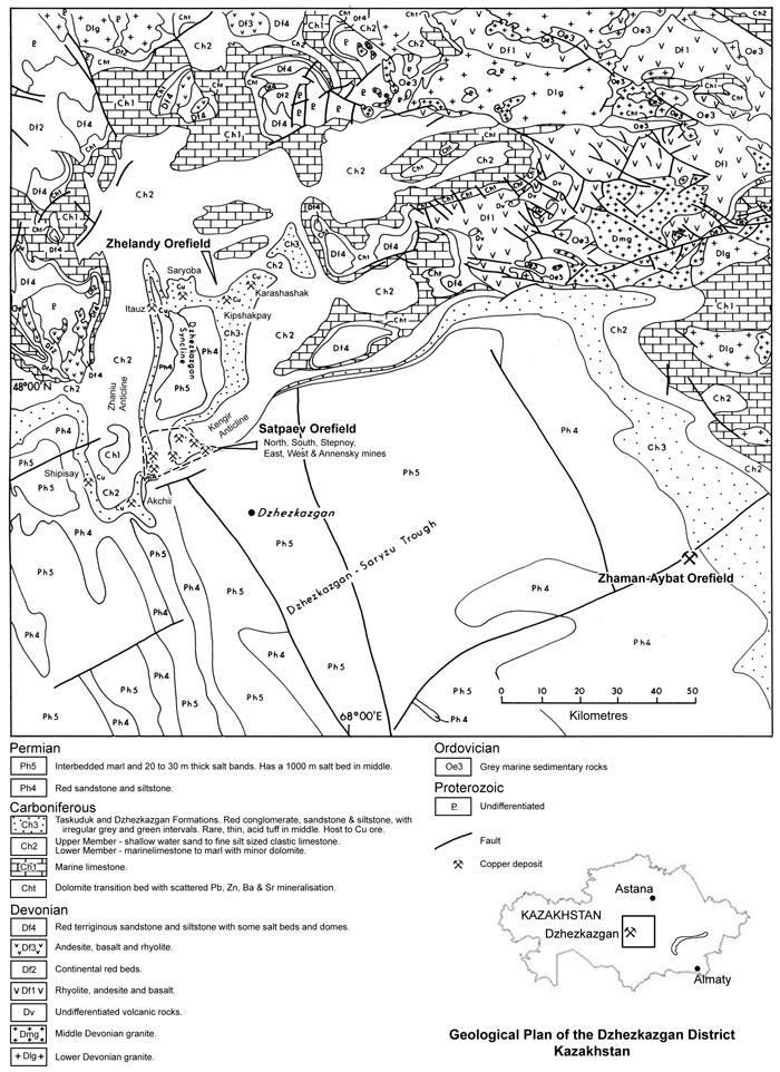
The Dzhezkazgan Cu deposits of the Satpaev and Zhelandy orefields, are located approximately 550 km north west of Almaty and 280 km WSW of Karaganda in central Kazakhstan and lies within the heart of the Kazakhstan-North Tien Shan Massif. In 2011 ore was being mined from the North, South, Stepnoy, East, West and Annensky mines in the Satpaev ore field (#Location: centred on 47° 51' 7"N, 67° 27' 22"E). Deposits in the Zhelandy ore field, 25 km to the north, include Itauz, East and West Saryoba, Kipshakpai and Karashoshak (#Location: centred on 48° 8' 20"N, 67° 25' 48"E).
Mineralisation is sediment hosted, within a sequence of upper Carboniferous to lower Permian clastics. The mineralised system is represented by 10 cupriferous stratabound bands, within the up to 630 m thick Dzhezkazgan Formation. Orebodies average 3 to 5 m in thickness, with maximum of 20 m. Only a limited number of these bands are of ore grade at a given point. The mineralised system covers an area of approximately 120 sq. km., extending down dip to a depth of 1000 m on its southern margin. Within the cupriferous bands, there are a series of large, elongated, partially overlapping orebodies, developed at a number of different levels, covering much of an approximately 9 x 6 km area.
The Zhomart mine exploits the 14 km long Zhaman-Aybat orefield deposits, ~160 km SE of Dzhezkazgan, interpreted to represent the same sequence, although only one 2 to 6 m (averaging 4.5 m) thick mineralised stratigraphic unit is mineable. The Taskura deposit is 10 km west of the Zhaman-Aybat ore field. (#Location: centre Zhaman-Aybat ore field 46° 49' 19"N, 69° 58' 34"E).
Copper mineralisation was first recognised at Dzhezkazgan by the armies of Jenghiz Khan in the 13th century, and has been exploited sporadically since then. The current operation (2013) is owned by Kazakhmys plc. The Dzhezkazgan complex was the worlds seventh largest producer of copper in 1994. Historic mine production includes:
1990 - 25.65 Mt @ 1.02% Cu, 0.82% Zn, 0.8% Pb, 13 g/t Ag,
2010 - 23.31 Mt @ 0.82% Cu.
Operations at Dzhezkazgan comprise both underground and one open pit mines. Head grades (as reported in 1993) from the open pits have historically averaged around 0.5% Cu, while the underground operations exploited grades of around 1.5% Cu, 13 g/t Ag.
Remaining measured + indicated resources as at 1 January, 2011 (IMC Consulting, Competent Person's Report to Kazakhmys plc, 2011) were:
Annensky mine - 47.817 Mt @ 0.84% Cu, 9.42 g/t Ag - underground, the most easterly Satpaev mine;
East mine - 54.182 Mt @ 0.71% Cu, 9.19 g/t Ag - underground, to the north of Annensky;
South mine - 103.275 Mt @ 0.71% Cu, 12.46 g/t Ag - underground in the south-central Satpaev area;
Stepnoy mine - 70.322 Mt @ 0.66% Cu, 11.90 g/t Ag - underground in the south-west Satpaev area;
West mine - 23.641 Mt @ 0.61% Cu, 13.91 g/t Ag - underground in the south-west Satpaev area;
Akchi Spassky mine - 21.307 Mt @ 0.61% Cu, 8.33 g/t Ag - open pit;
Sredny Spassky mine - 7.095 Mt @ 0.53% Cu, 4.95 g/t Ag - open pit;
Zhelandy mine - 4.879 Mt @ 1.01% Cu, 7.97 g/t Ag - open pit;
Other Satpaev open pits (Annensky 3 & West, Zapadny, Pokro North, Kresto) - 8.436 Mt @ 0.56% Cu, 4.91 g/t Ag;
Zhomart mine - 135.995 Mt @ 1.56% Cu, 18.69 g/t Ag - underground Zhaman-Aybat mine;
TOTAL resource in current Dzhezkazgan and Zhaman-Aybat mines - 476.949 Mt @ 0.94% Cu, 13.07 g/t Ag.
Other undeveloped resources include:
Itauz - 38.65 Mt @ 1.12% Cu, 8.37 g/t Ag - underground Zhelandy orefield, below open pit;
West Saryoba - 33.71 Mt @ 1.58% Cu, 21.47 g/t Ag - underground Zhelandy orefield;
East Saryoba - 34.50 Mt @ 1.48% Cu, 21.68 g/t Ag - underground Zhelandy orefield;
Kipshakpai - 20.06 Mt @ 1.36% Cu, 22.78 g/t Ag - underground Zhelandy orefield;
Karashoshak - 7.10 Mt @ 1.46% Cu, 6.22 g/t Ag - underground Zhelandy orefield;
TOTAL undeveloped resources - 133.92 Mt @ 1.38% Cu, 17.21 g/t Ag.
TOTAL remaining Dzhezkazgan underground resources - 299.237 Mt @ 0.71% Cu, 13.97 g/t Ag excluding Zhomart;
TOTAL remaining Dzhezkazgan open pit resources - 41.717 Mt @ 0.63% Cu, 6.95 g/t Ag;
Remaining Zhomart underground resources - 135.995 Mt @ 1.56% Cu, 18.69 g/t Ag.
Geology
The mineralisation at Dzhezkazgan is hosted by an upper Palaeozoic sequence that commenced with a Devonian bi-modal volcanic and red bed sequence, followed by marine, shelf and red-bed sequences in the Carboniferous and Permian. The orebodies are hosted by the upper-most Carboniferous units. The main depository of the Permo-Carboniferous sequence is the 200 to 250 km wide by 800 km long, NW-SE elongated Dzhezkazgan-Saryzu (or Chu-Sarysu) Trough, which lies between two major structures, the Karatau and Zhalair-Naiman faults, to the SW and NE respectively. A number of parallel structures, such as the Kokshetau Fault in the core of the basin, passing through Dzhezkazgan, affect the geometry of the trough. The northern limit of the trough, corresponds to a broad, ENE-WSW-trending hinge zone/dislocation. To the south of this hinge zone, the sequence dips south and thickens rapidly into the trough. To the north of this structure, it thins dramatically and is overall shallowly dipping, in a series of synforms/antiforms and grabens that trend north-south.
The Satpaev orefield at Dzhezkazgan is developed over the hinge zone at the mouth of the Dzhezkazgan syncline/graben which opens to the south into the main Dzhezkazgan-Saryzu Trough. The Zhelandy orefield is elongated ENE-WSW over a 16 km interval, some 25 km to the north, along the northern closure of the syncline.
The Zhaman-Aybat orefield is towards the eastern margin of, but well within the thicker section of the Dzhezkazgan-Saryzu Trough, ~160 km SE of Dzhezkazgan, controlled by another ENE-WSW-trending structure, represented by a monoclinal flexure (see Structure, below). The deposit is not exposed and was discovered in 1981 at 300 to 700 m depths.
The upper Palaeozoic sequence in the Dzhezkazgan area comprises the following, from the base:
Ordovician - Grey marine sediments of indeterminate thickness, resting on a metamorphosed Proterozoic basement.
Unconformity
Devonian - Early and Middle Devonian volcanic and volcaniclastic rocks (Windley et al., 2007) on the eastern margin of the basin, passing eastward into an extensive Early Devonian to Lower Permian continental volcanic province. Westward, this volcanic sequence interfingers with, and grades upward into, a Middle and Upper Devonian continental red-bed facies, with a thick sequence of Upper Devonian to Mid Carboniferous carbonate carbonate shelf sequence to the west of the main basin. Within the basin, the Devonian sequence comprises:
Unit F1 - rhyolite, andesite and basalt, resting on Lower Devonian granites;
Unit F2 - continental red beds;
Unit F3, 800 to 1200 m thick - andesite, basalt and rhyolite belonging to the Middle Devonian volcanic arc;
Unit F4, 2000 to 2500 m thick - red terrigenous sandstone and siltstone with some salt beds and domes;
Carboniferous
Transition Bed - a thin, discontinuous dolomite found at the transition from the Devonian to the Carboniferous, marking the beginning of marine conditions, and subsidence within the Dzhezkazgan-Saryzu (or Chu-Sarysu) Trough. There is minor Pb/Zn mineralisation and concentrations of Ba and Sr on its lower contact;
Unit H1, up to 3000 m thick - marine limestone and dolomite with lagoonal evaporite facies in the lower part. These rocks are continuous with the regional carbonate platformal sequence across the Karatau Fault to the SW of the trough (Cook et al., 2002).
Unit H2 - Lower Member, 3000 m thick - marine limestone to clayey-limestone or marl, with minor intercalated dolomite. Amorphous pyrite occurs within the marls.
- Upper Member, 200 to 500 m thick - shallow water, terrigenous-derived, fine grained calc-siltstone and mudstone, grading to calcarenite. In the top sections lenses of Cu mineralisation up to 20 cm thick may be found at the contact with the overlying Unit H3. This interval is characterised by thin banding and black sandstones and marks an upward transition from marine to continental deposition;
Unit H3, Taskuduk and overlying Dzhezkazgan Formation, from 20 to 630 m thick - which hosts the Cu mineralisation of the major Dzhezkazgan orebodies. The Zhelandy and Satpaev orefields are respectively hosted by the Taskuduk and Dzhezkazgan formations. This composite unit comprises a red, continental sequence of conglomerates, sandstones and siltstones, characterised by alluvial facies deposited by palaeorivers that flowed into the basin from its margins. Rocks within the sequence have been locally reduced to a grey or greenish-grey colour in the vicinity of the orebody. The reduced beds consist of compact, uniform, fine-, medium- and coarse-grained rocks with a grey and greenish-grey colour. They contain angular 0.25 to 0.6 mm, and rarely up to 1 mm, clasts of feldspar and quartz in a fine siliceous-carbonate matrix. The grey sandstones are characterised by a clear stratification, emphasised by intercalations of the red varieties. Grey siltstones are rare. The red siltstones and sandstones are distinguished only by the somewhat smaller clasts and by the clay-carbonate content of the matrix. The ratio of green:red lithologies is approximately 1:1. The ratio of sandstone:siltstone is 1:1, and conglomerate:sandstone 1:30. Variable amounts of 'gypsum' impregnate the sandstones. Conglomerates are present as both intra- and inter-formational varieties. The former are generally 0.8 to 2 m thick, locally grading laterally into sandstone and sometimes into siltstone. The clasts are usually 0.5 to 1 cm in diameter and rarely up to 5 cm, comprising locally sourced rock, in a matrix of the enclosing sandstones. The interformational conglomerates have angular exotic clasts (Mine Visit, 1993; Smirnov, 1977);
Sulphate Unit, 0 to 100 m thick - a discontinuous gypsum rich band up to a maximum of 100 m in thickness, containing 3 to 5% SrSO4;
Permian
Unit H4, Zhidelisai Formation, 600 to 800 m thick - red beds, which have the same ratios of conglomerate:sandstone:siltstone as the Dzhezkazgan Formation, but with no reduced grey or green intervals and patches. There are also no carbonates. Halite and sylvite layers are found low in the unit in the main basin to the south of Dzhezkazgan, while some methane, helium and nitrogen accumulations have also been encountered within it, less than 30 km to the south of the mine. Within the main basin, this unit grades up into the up to 900 m thick, Lower to Upper Permian Kengir Formation, comprising a non-marine, lacustrine sequence of interlayered limestone, marl and fine clastic (mainly shales) rocks. The clastic rocks are red in the lower part of the sequence;
Black Pyritic Unit, average 0.2 m thick - a Kupferschiefer type pyritic and carbonaceous (2 to 5% TOC) shale layer. This unit is absent at Dzhezkazgan, but is found in the Tengiz Basin, 350 km to the north, where it contains Cu mineralisation. It is apparently a close time correlate of the Kupferschiefer of western Europe, the nearest exposures of which are found some 3500 km to the WNW in Poland. In the Dzhezkazgan area the units above and below the position of the absent shale are red and lacustrine;
Unit H5, 30 to 2500 m thick - marl, and interbedded marl and 20 to 30 m thick salt beds. A major 1000 m thick salt bed found in the middle of the unit is probably a correlative of the Zechstein Salt in the North Sea/Polish Basin sequence in Europe. This unit is widely developed above and to the south of Dzhezkazgan.
Lower Devonian granites to the north-west of Dzhezkazgan cut Ordovician rocks, but are basement to the Devonian volcanics of Unit F1. Within the same area, the Devonian sequence is cut by middle Devonian granites. These are co-magmatic with the Devonian volcanic units. Within the Proterozoic basement block to the NNW there are exposures of lower Carboniferous to lower Permian (360 to 260 Ma) gabbroic intrusions, which can apparently be geophysically traced SSE towards Dzhezkazgan. Similar gabbro masses are described deep in the hinge zone that forms the northern margin of Dzhezkazgan-Saryzu Trough below the Kengir (or Kingir) Anticline (Mine Visit, 1993).
Within the main Dzhezkazgan-Saryzu (or Chu-Sarysu), the folded Devonian to Permian rocks are unconformably overlain by gently dipping Upper Cretaceous-Paleogene and Neogene continental strata (Box et al., 2012).
Structure
The Dzhezkazgan mineralised zone lies over a major east-north-east trending basement dislocation that can apparently be traced to a depth of 70 to 80 km by deep seismic. To the south, gently dipping, thick Permo-Carboniferous sequences of the main Dzhezkazgan-Saryzu Trough are represented. In contrast, to the north, thin developments of the same sediments are preserved in NNW trending synclines over a complicated basement of Proterozoic and lower to middle Palaeozoic granites, volcanics and sediments. This dislocation has resulted in a broad zone, around 1 km wide, of schist development within pre-Carboniferous basement. It appears to have been active during the deposition of the Permo-Carboniferous sediments, with these sediments thinning markedly from south to north across the dislocation zone.
An antiformal structure within the Permo-Carboniferous sediments parallels, and lies above this structure, having also been formed during deposition. This is the Kengir Anticline, that broadly corresponds to the Satpaev orefield. This antiform appears to represent a draping of the cover sediments over the rising major basement structure. The core of the antiform corresponds to a thinning of the cover sequence, from both the south and north, above the basement structure. This indicates syn-depositional uplift of the southern margin of the northern plate along the major dislocation zone.
A further set of structures are the NNW to north-south trending set of horst-graben and related F2 anticline-syncline structures which were also active during the deposition of the Permo-Carboniferous cover sequence. These are represented by the Dzhezkazgan Syncline and the Zhaniu Anticline over which the sequence respectively thickens and thins. The grabens of this set of structures acted as embayments of the Dzhezkazgan-Saryzu Trough onto the basement to the north. The Dzhezkazgan Syncline is asymmetric, with a steep to overturned (generally 50 to 80°) western limb which it shares with the Zhaniu Anticline, and a stepped, more gentle (3 to 20°) south-eastern limb onto the Kengir Anticline. The syncline is locally modified by parallel monoclinal structures associated with NNE-SSW trending fractures. Ore is distributed over an area of 4 km north-south by 16 km east-west, within the Zhelandy orefield at the northern closure, ~25 km to the north of the Satpaev orefield.
Overall, the Zhelandy deposits are distributed along an ENE trend within a broader ENE-trending band of bleached grey-green sandstone and conglomerate with reduced iron within the predominantly oxidised red-bed Taskuduk Formation. The bleached zone and the Zhelandy deposit trend are aligned along the minor F1 Zhelandy anticline, parallel to, and the first such structure to the north of the F1 Kengir anticline. The the individual Itauz, and West and East Saryoba orebodies, are each oriented north-south, following, or aligned parallel to, the axes of separate F2 synclines where they cross the F1 Zhelandy anticline, similar to the structural setting of the Satpaev orefield. Kipshakpay and Karashoshak are narrow bodies that trend ENE along the southern flank of the Zhelandy anticline, close to the flanking F1 syncline that controls the northeastern margin of the Dzhezkazgan sub-basin. The copper ores of the Zhelandy orefield are hosted by the lowest unit of the Taskuduk Formation.
The sediments within the Dzhezkazgan Syncline, although largely gently dipping, are characteristically monoclinally folded into a series of step like structures, with a flat lying bed steepening over a hinge before flattening again at another hinge. This is interpreted again to represent draping of the cover sequence over a series of step faults in the basement associated with the development of the graben in which the cover sequence was deposited. Basement faults trending NNW-SSE, north-south and WSW-ENE are evident in seismic data, consistent with this interpretation. These faults do not generally rupture the Permo-Carboniferous cover sequence, but where they do, they are commonly filled with pebble dykes. The core of the syncline is occupied by Permian rocks.
The main Dzhezkazgan mineralised zone of the Satpaev orefield is centred over the major ENE basement dislocation and coincident Kengir Anticline, where they are intersected by the NNW trending Dzhezkazgan Syncline, in the mouth of the Dzhezkazgan embayment of the Dzhezkazgan-Saryzu Trough.
The Zhaman-Aybat and Taskura orefields are aligned along the crest of an asymmetric, NW-verging, ENE-WSW trending, monoclinal flexure system within the Dzhezkazgan-Saryzu Trough, with associated parallel to sub-parallel, SE-dipping reverse faults which cross-cut the regional west dips of the host units. Immediately to the north of the deposits of the orefield, this structural trend downthrows the Permo-Carboniferous sequence. A series of fault-bounded sub-parallel blocks, characterised by anticlinal faults are found to the south of this structure, with the orebodies concentrated along the anticlinal axes, producing a 25 km long, linear mineralised zone. Stratigraphic markers allow correlation of the Taskuduk and overlying Dzhezkazgan Formations between the Dzhezkazgan and Zhaman-Aybat orefields.
Mineralisation
The host Dzhezkazgan Formation in the Satpaev orefield is up to 630 m thick in the mine area and encloses 10 mineralised sandstone members, although units 2 to 9 contain the bulk of the resource. Each of these mineralised members contains 2 to 5 potential ore bearing layers ore-bearing sandstone beds at any one location. Overall there are usually 29 potential ore bearing layers in any part of the main 9 x 6 km mineralised area on which the Dzhezkazgan mines are located. At any one point however, 5 to 7 of these 27 layers will be mineable with grade-thicknesses in excess of the underground cutoff. There are geographically distinct distributions for each of the ore horizons. These individual mineralised bands thin, decrease in number, and lens out down dip towards the margin of the deeper, outer sections of the larger 120 sq. km. zone of mineralisation. Below depths of 700 m the mineralised layers are generally too thin and low grade to be economic. Orebodies are typically elongate, forming linear or arcuate trends several km long and <1 km wide. The larger individual orebodies cover areas of 5 to 7 sq. km.
The copper ores of the Zhelandy orefield are hosted by the lowest unit of the Taskuduk Formation.
Cu sulphide mineralisation occurs as intergranular cement and detrital grain replacement, primarily hosted in grey or greenish-grey reduced sandstone and conglomerate, which
are interbedded with unmineralised reddish siltstone and shale. The deposit is partially exposed at the surface, with surface oxidation penetrating to depths of up to 100 m. The form of mineralisation is described below (Description of ore section).
In the Zhaman-Aybat orefields, only 10 mineralised groups are recognised distributed over a stratigraphic interval of 1000 m, each with a number of horizons, only one of which (horizon 4-1) is economically exploited. Other horizons (4-III, 4-II, 3-IV and 3-I) are well mineralised, but lensoid and discontinuous. Horizon 4-I, a lithic conglomerate unit at the base of the Dzhezkazgan Formation, occupies the nearly horizontal, or broadly flexured, axis of an ENE-WSW anticline, which plunges gently (3 to 5°) west, over an interval of 14 km and maximum north-south width of 4 km. The copper sulphide mineralisation shows patchy laterally and vertically variable, with the highest grade zones characterised by chalcocite, which grades outward, through bornite to chalcopyrite. Other minerals include djurleite, digenite, galena, sphalerite, argentite and native Ag. Significant silver values are consistent, but polymetallic and Pb-Zn values are localised. In 2011, the mined area was 6 x 1.8 km (IMC Consutants, 2011).
The Taskura ore field, ~8 km to the west of Zhaman-Aybat comprises low-grade sandstone Cu mineralisation, capped by a small, low-grade reduced-facies Cu shale deposit, hosted within the Permian Zhidely-Sai series (H4?). Only one mineralised horizon has been identified, which was briefly mined by open pit before closure due to grades being lower than predicted (IMC Consutants, 2011).
The lowering of the cutoff grade for shallow overburden open pit mining means that mineralised bands that would be un-economic underground can be can be combined to form a larger bulk tonnage. Consequently the numbers of mineable layers at any one point will be greater than is quoted above.
Mineralisation is controlled by the reduction state of the host sediments, being restricted to the reduced grey and green layers and zones. These reduced zones comprise approximately 50% of the Dzhezkazgan Formation in the mineralised zone of the Satpaev orefield. They do not appear to represent original depositional facies, and vary without visible patterns within wide limits. The grey-green zones and bands are between 7 and 42 m in thickness, alternating with the red lithologies which are from 2 to 28 m thick. Statistically the red varieties are predominantly siltstones, while the grey zones are sandstones. The latter consist of compact, uniform, fine-, medium- and coarse grained rocks, containing angular clasts of quartz and feldspar from 0.25 to 0.6 mm, and rarely up to 1 mm. The matrix is siliceous-carbonate. Some coalified plant detritus has been found within these sediments.
There is evidence to suggest that the grey-green lithologies are reduced red rocks. This is supported by: i). the reduced lithologies statistically being the more permeable; ii). the gradational and transgressive nature of the contact between the two; iii). the persistence of reduced conditions in sand dykes crossing red lithologies and the diffusion of the boundary into the wall rock of the dyke; iv). the presence of relict red kernels within the reduced zones; etc.
In addition the zone of reduction is localised over the crest of the Kengir Anticline, lensing out into a wholly oxidised sequence in the Dzhezkazgan-Saryzu Trough on the southern limb of the anticline, and similarly to the north, into the main Dzhezkazgan Syncline.
The Zhelandy deposits are distributed along an ENE trend within a broader ENE-trending band of bleached grey-green sandstone and conglomerate with reduced iron within the predominantly oxidised red-bed Taskuduk Formation, as described above in the Structure section.
The Zhaman-Aibat and Taskura deposits are centred within a 35 km long, ENE trending, 1 to 5 km wide zone, in which red-bed sandstones of the Dzhezkazgan and Taskuduk Formations are irregularly reduced to a grey colour, with interbedded siltstone and shale strata retaining their red hues. This multicoloured zone of reduced sandstone and oxidised siltstone-shale forms an up to 250 m thick lens within the two formations. At Zhaman-Aibat, organic matter (TOC) increases from 0.05% in red-bed siltstone-shale horizons to 0.15% in the interbedded grey sandstones, entirely due to an increase in bitumen. The gas and bitumen content of these sandstones indicates that they have hosted petroleum fluids.
These observations at Dzhezkazgan and Zhaman-Aibat have been interpreted to imply that reduction has accompanied the accumulation of hydrocarbons, maturated from the underlying lower Carboniferous petroliferous carbonates, into an anticlinal trap zone, thus reducing pre-existing iron oxides in the red-beds.
Relationship of ore to faults - There is claimed to be a relationship between the degree of mineralisation and the density of faulting within the basement which has produced the monoclinal flexures in the host cover sequence. These basement faults, as described in the 'Structure' segment above, are distributed in NNW-SSE, ENE-WSW and north-south directions. In addition, where there is a high density of faulting and flexuring a greater percentage of the Dzhezkazgan Formation is mineralised. Where the density is lower, only the basal beds are mineralised. The general frequency of such flexures/faults in the mine area is every 0.5 to 1 km. In some cases the ore is preferentially concentrated in the arches and crests of the flexures, while in others it is in the steeper limbs, with lesser amounts in the lower hinges of the monoclinal flexures.
Authigenic minerals - There is a strong laterally and vertically zoned impregnation of gypsum and halite within sections of the Permo-Carboniferous cover sequence. Within the Dzhezkazgan area the red units contain appreciable 'gypsum' within Unit H3, the Dzhezkazgan Formation. Away from ore, on the shared limb of the Dzhezkazgan Syncline and the Zhaniu Anticline where the sequence is almost completely oxidised, all 10 units that are mineralised within the ore zone contain abundant 'gypsum'. However within the sulphide bearing reduced rocks in the immediate vicinity of Dzhezkazgan, there is little to no gypsum, although it is present within interbanded red lithologies, particularly in the section above the orebodies. Within the sulphide bearing reduced rocks the cement is mainly carbonate, rather than gypsum. This is taken to imply that the sulphur of the 'gypsum' has been consumed in the formation of sulphides.
There is also a lateral 'primary' variation in authigenic gypsum content. To the south into the Dzhezkazgan Saryzu Trough, the proportion of the red sequence containing gypsum decreases, as does the gypsum content. Similarly to the north into the Dzhezkazgan Syncline, the number of units and thickness of gypsum impregnation decreases, although on the margins of the syncline appreciable amounts are still present. Mineralisation is also present in these same zones. However, despite the drop in levels, regionally 'gypsum' is a relatively constant component of Unit H3.
Within Unit H3, the 'gypsum' is mainly SrSO4, with the sequence containing 6 to 8% of that mineral over thicknesses of 50 to 80 m. Higher in the sequence, at the base of the exclusively red bed Unit H4, a thick band of gypsiferous marl containing 3 to 5% SrSO4 is frequently found. Higher still, in Unit H5, halite and sylvite are abundant, with little or no gypsum.
It therefore appears likely that there is a relationship between the development of sulphides and the presence of pre-existing authigenic sulphate, possibly also concentrated in structural positions, in a similar fashion to the inferred reductant hydrocarbons. Little hydrocarbon remains in the sulphide zone, probably also having been consumed in the production of carbonates and sulphide through the reaction/combination with the sulphates. Hydrocarbons are found within the main Dzhezkazgan Saryzu Trough to the south, trapped within Unit H4.
Zoning and morphology of ore - The main orebodies of the Satpaev orefield are confined to Unit H3, in the nose/crest of the Kengir Anticline. In the lower of the 10 mineralised units, namely from 2 to 5, the orebodies are curved and elongated, paralleling the strike of the enclosing sediments in the shallow nose of the anticline. Higher in the sequence these elongate bodies are progressively rotated in an anticlockwise direction relative to the underlying bodies, and are broken into branches, as illustrated on the accompanying plan (Gablina, 1981). The individual larger bodies illustrated are of the order of 5 to 6 km in length and 1 km wide. The average length:width ratio if the orebodies is 5:1. Smaller orebodies in the upper sections of the deposit are 50 to 100 m wide and several kilometres long. Other smaller deposits may be 400 m wide and have a similar length. Thicknesses of underground orebodies range from 0.5 to 20 m (Smirnov, 1977). In the underground mine visited, four ore layers were being mined, each with a thickness of around 6 m, to a maximum of 10 m.
Over 90% of the ore is composed contains the sulphides chalcocite, bornite and chalcopyrite. Each of the orebodies possesses a mineralogically zoned structure. The outer, convex, deeper section of the ore is predominantly chalcocite. In a north-easterly direction, towards the Kengir Anticline, there is a progression from chalcocite, to bornite and then chalcopyrite, with textures indicating the chalcocite zone typically migrated into a pre-existing bornite zone, which, in turn, migrated into a pre-existing chalcopyrite zone (Gablina, 1981). In the chalcocite zone djurleite (Cu1.96S) predominates, with lesser digenite (Cu1.8S). However in the chalcocite-bornite zone, digenite predominates over djurleite, accompanied by the 'excess-Cu' pink bornite. As the chalcopyrite zone is approached the Cu content of bornite decreases until the 'excess-sulphur' X-bornite (Cu5-xFeS4+x) predominates. In the chalcopyrite zone, that mineral alone is present, although some pyrite appears on its north-eastern margin (Gablina, 1981). Galena and sphalerite are found in the lateral extremities of the orebodies, beyond the chalcopyrite zone. There is also a vertical stratigraphic zonation, with chalcopyrite in the upper layer and chalcocite in the lowest. Galena and sphalerite are concentrated lower in the sequence, below the Cu mineralisation. Silver is present either as the native metal, or in the lattice of the sulphides, progressively increasing in the following sequence, from galena to chalcopyrite to bornite to chalcocite (Smirnov, 1977). Rhenium is also a constant constituent of the Cu ore, accompanying silver. Galena, unlike sphalerite, may also be found within the orebody, associated with chalcocite and bornite. As such it is mined and treated with the Cu, whereas sphalerite which only occurs outside of the Cu zone, must be mined separately. The presence of djurleite within chalcocite ores (Gablina, 1981) at Dzhezkazgan implies an upper temperature limit of 93°C for precipitation of the ores (Roseboom, 1966).
In 2011, underground ore cut-off was 0.3% Cu, with a minimum average grade of >0.4% Cu over a minimum thickness of 3 m. The open-pit cut-off was 0.2% Cu, for an average grade of 0.5% Cu (IMC Consultants, 2011).
The orebodies have no clear boundaries, with their margins being determined by assays alone. The richest ore however, is associated with conglomerates, while the poorest is in siltstones. As such there appears to be a correlation between permeability/grain size and grade.
Three generations of sulphide mineralisation were recognised by Gablina (1981) at Satpaev/Dzhezkazgan: i). The earliest includes fine grained (<0.01 mm) globular and crystalline sulphides, coating the margins of clastic grains or accumulations of early generation calcite, and coated by later calcite or authigenic silica cement. Richer ores show partial to complete replacement of feldspar and other framework grains. ii). These are followed by pseudomorphs of sulphide after iron hydroxides and oxides within calcite or quartz cements, or within bleached argillites close to a sandstone contact. i). The last generation occurs as accumulations of sulphides which fill micro-pores or cracks in detrital pebbles or sand grains. Narrow mineralised joints with a gangue of quartz, barite, or calcite occur widely within the disseminated sandstone orebodies but are not economically important.
The deposits of the Zhelandy orefield are mostly characterised by chalcocite and bornite, with extensive lower grade disseminated chalcopyrite and local galena occurring in the peripheral reduced iron zone outside the economic parts of the deposits. Within each orebody, the chalcocite ores are more centrally located and are surrounded by bornite or chalcocite-bornite ores. The Itauz deposit is located on the overturned western limb of a tight syncline with dips of ~70°W and a strike exposure of about 7 km. Underground resources persist for at least 800 m below the surface. The East and West Saryoba deposits contain central chalcocite ore zones along F2 synclinal axes, with bornite and bornite-chalcocite located up-dip on both flanks of each syncline.
Copper ore within the Zhaman-Aibat deposit is distributed in two butterfly-shaped wings, connected by a narrow neck. The ore blocks trace the outline of each wing around a barren core, approximately centred on domal culminations along the ENE trending F1 monocline at the intersections with NNW trending F2 anticlines. The principal ore minerals are chalcocite, bornite, chalcopyrite and galena. In general chalcocite occurs on the outer sections of the wings, passing into chalcocite-bornite to chalcopyrite, influenced by the F1 synclinal and anticlinal pair of the monocline, and the axes of F2 anticlines. Galena overlaps with chalcocite or bornite-chalcocite in the southern part of the west wing and occurs alone at the north end of the area between the wings. The West wing of the deposit has an average thickness of 6.2 m (Satpayeva, 2006) but ranges from 2.6 m thick on the periphery to 16 to 20 m in an interior thickened 500 x 500 m zone adjacent to the barren core. The East wing consists of an oblong, composite deposit with an average ore thickness of 2 to 4 m, locally up to 8 m (Box et al., 2012).
Description of ore - Mineralisation is almost exclusively hosted by reduced, grey and greenish-grey sandstones and where present, conglomerate. The mineralised sandstones have a dark grey colour and a metallic appearance due to the presence of sulphides. The ore is overall sulphide poor, containing only the copper-ore-sulphides listed above. The most common ore is present as disseminated sulphides within the matrix of the sandstones and conglomerates, and less frequently by replacement of feldspar and even quartz. The ore fabric is often banded, being defined by the texture of the host rock. In the more weakly mineralised rock the sulphides are concentrated in the coarser grained beds and laminae. In the richest ore there is a high sulphide content, approaching semi-massive sulphides, although the rock fabric is still that of the original host. Vein mineralisation with a gangue of quartz, barite or calcite occurring within joints and crush zones is widespread, but of little economic importance (Mine Visit, 1993; Smirnov, 1977).
Within the orebody there are both red and green beds. The red varieties contain ferrous oxides and hydroxides, while the green carries ferric hydroxides. There is a brown transition between the two with diffuse margins, often irregularly transgressing bedding, and containing relict patches of green and red. In places the margin between green and red bands is sharp. Some green varieties contain what appear to be clasts of red siltstone, while the reverse is also observed. Both the brown and red sediments are waste, only the green is ore. Calcite gash veins from 1 to 5 mm thick and 10 to 50 cm long are found within the ore zone.
Within the zones of ore grade mineralisation, bornite and chalcocite are present as fine disseminations within the grey and greenish-grey sandstones, un-accompanied by other sulphides, and appearing as finely dispersed 'fly-specks' <1 mm across. In higher grade specimens sulphides are concentrated as dense disseminations forming clots and clouds, while small lenses of chalcocite may occur within the ore. In exceptional samples bornite may form a matrix to a fine breccia in siltstones, while disseminated mineralisation may accentuate flaser structures, or be concentrated in slump structures and in the foresets of cross-bedding.
Oxidation - The orebodies are affected by oxidation over a vertical interval of 8 to 12 m, with no marked changes in the Cu content in the oxide zone, which is primarily composed of malachite, azurite and chrysocolla. This is apparently a consequence of the high carbonate content of the matrix which quickly neutralises any acid leaching of copper, resulting in oxidation and in situ re-deposition, but no transport of secondary Cu. In zones adjoining fault zones however, deeper oxidation and supergene modification takes place to depths of from 10 to 70, and locally to 100 m. The mineralogy of the oxidised zone itself consists of Fe and Mn hydroxides, native copper, cuprite, malachite, azurite, bronchantite, ehlite and chrysocolla. In the supergene sulphide zone covellite, secondary chalcocite and bornite are recorded (Smirnov, 1977).
The most recent source geological information used to prepare this decription was dated: 2010.
Record last updated: 6/4/2013
This description is a summary from published sources, the chief of which are listed below.
© Copyright Porter GeoConsultancy Pty Ltd. Unauthorised copying, reproduction, storage or dissemination prohibited.
Satpaev ore field Zhelandy ore field Zhaman-Aybat ore field
|
|
|
|
|
Box, S.E., Syusyura, B., Hayes, T.S., Taylor, C.D., Zientek, M.L., Hitzman, M.W., Seltmann, R., Chechetkin, V., Dolgopolova, A., Cossette, P.M., and Wallis, J.C., 2012 - Sandstone Copper Assessment of the Chu-Sarysu Basin, Central Kazakhstan: in U.S. Department of the Interior, U.S. Geological Survey, Scientific Investigations Report 2010-5090-E, 63p.
|
Gablina I F 1981 - New data on the formation of the Dzhezkazkan copper deposit: in International Geology Review v.23 pp. 1303-1311
|
Germanov A I, Panteleyev V M and Golubovich V N, 1971 - Certain aspects of geochemistry of copper in Dzhezkazgan: in International Geology Review v.13 pp. 1492-1500
|
Zientek M L, Hayes T S and Hammarstrom J M 2013 - Overview of a New Descriptive Model for Sediment- Hosted Stratabound Copper Deposits: in Zientek M L, Hammarstrom J M and Johnson K M, 2013 Descriptive Models, Grade-Tonnage Relations, and Databases for the Assessment of Sediment-Hosted Copper Deposits - With Emphasis on Deposits in the Central African Copperbelt, Democratic Republic of the Congo and Zambia USGS Scientific Investigations, Report 2010-5090-J pp. 2-16
|
|
Porter GeoConsultancy Pty Ltd (PorterGeo) provides access to this database at no charge. It is largely based on scientific papers and reports in the public domain, and was current when the sources consulted were published. While PorterGeo endeavour to ensure the information was accurate at the time of compilation and subsequent updating, PorterGeo, its employees and servants: i). do not warrant, or make any representation regarding the use, or results of the use of the information contained herein as to its correctness, accuracy, currency, or otherwise; and ii). expressly disclaim all liability or responsibility to any person using the information or conclusions contained herein.
|
Top | Search Again | PGC Home | Terms & Conditions
|
|


