|
Central Arabian Gold and Base Metal Region - Mahd Ad Dhahab, Jabal Sayid, Al Amar, Bulghah, Al Sukhaybarat, Hamdah, Al Hajar, Jadmah, Sherrs, Wadi Bidah, Shaab Al Taare, Rabathan, Ad Duwayhi, As Suq, Mansourah, Bir Tawilah, Ar Rjum, Al Masane, Kutam |
|
|
Saudi Arabia |
| Main commodities:
Au Zn Cu
|
|
 |
|
|
 |
Super Porphyry Cu and Au


|
IOCG Deposits - 70 papers
|
All papers now Open Access.
Available as Full Text for direct download or on request. |
|
|
The Central Arabian Gold and Base Metal Region hosts a series of significant gold and polymetallic deposits distributed over an area of ~600 x 400 km in central Saudi Arabia. These include:
Mahd Ad'Dhahab,
Jabal Sayid,
Al Amar,
Bulghah,
Al Sukhaybarat,
Hamdah,
Al Hajar (Hajr), Jadmar,
Wadi Bidah District,
Ad Duwayhi,
As Suq,
Mansourah, Masarrah and Bi'r Tawilah,
Ar Rjum Goldfield,
Al Masane and
Kutam, as described individually below.
Regional Tectonic and Geologic Setting
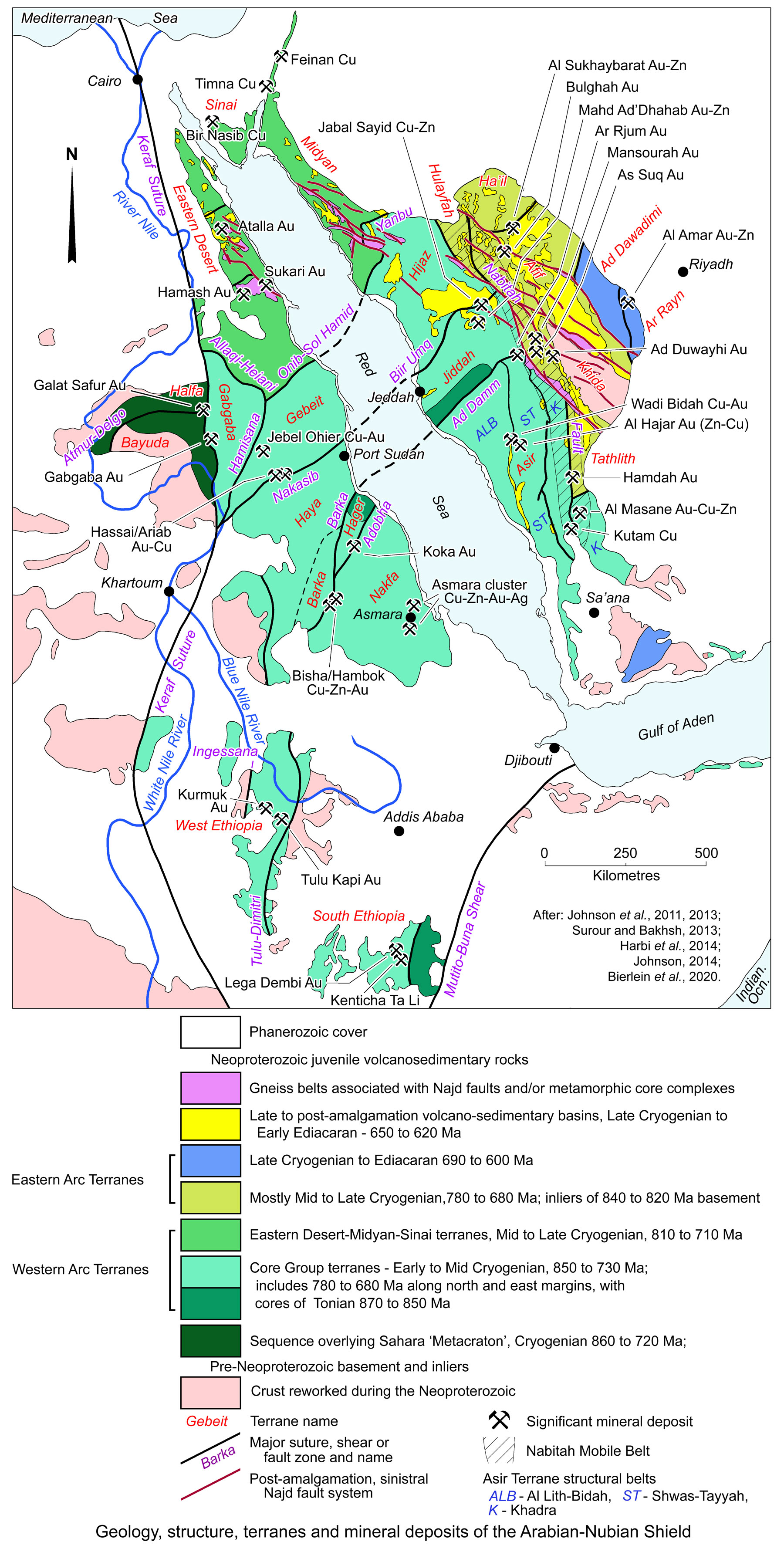
The Arabian Shield is the eastern segment of the more extensive Arabian-Nubian Shield that straddles the Red Sea within NE Africa and the Arabian Peninsular. It is predominantly composed of juvenile Neoproterozoic crust of oceanic affinity. For a description of the regional setting and geology, see the separate Arabian Nubian Shield Overview record.
As detailed in the Arabian Nubian Shield Overview record, the shield is divided into a series of terranes with differing structural and geologic characteristics reflecting its Neoproterozoic plate tectonic evolution. In general, most terranes are composed of earlier Late Tonian to Cryogenian intra-oceanic magmatic arcs, unconformably overlain by late to post-tectonic marine to terrestrial basins filled with molassic volcano-sedimentary sequences and intruded by voluminous granitoid batholiths. The geology of each of the terranes of the Arabian section (i.e., east of the Red Sea) of the shield (see Fig. below) may be summarised as follows (after Johnson, 2006; Stoeser and Frost, 2006; Johnson et al., 2013; Al-Husseini, 2015; Stoeser et al., 2001; Greenwood et al., 1983):
Asir Terrane - a composite terrane composed of three north-south trending structural belts, from west to east:
• Al Lith-Bidah Belt composed of early Cryogenian 855 to 815 Ma metamorphosed (to gneisses and schists) basaltic and andesitic flows, flow breccia and coarse fragmental rocks with subordinate lithic and crystal dacitic tuff and lesser interbedded volcaniclastic and epiclastic rocks and accompanying thin marble beds.
• Shwas-Tayyah Belt to the east of the Al Lith-Bidah Belt, composed of metamorphosed basaltic, andesitic and dacitic volcanic and pyroclastic rocks and associated volcaniclastic and epiclastic metasedimentary rocks (Greenwood et al., 1983). The belt is >795 Ma, but possibly younger than the Al Lith-Bidah belt (Johnson et al., 2013). The structural belt is intruded by the 815 to 795 Ma pre-tectonic mafic to intermediate plutonic rocks of the An Nimas batholith. In the north, it includes the pre 815 Ma Muwayh Formation, a succession of predominantly interbedded basaltic and andesitic lavas, agglomerate, breccia, and lithic-lapilli, crystal, and ash tuffs with subordinate dacitic and rhyolitic volcanics, as well as conglomerate, sandstone, quartzite, calc-silicate rock and ironstone, all of which are metamorphosed to the greenschist facies. It is intruded by plutons, sills and dikes of diorite, tonalite, granodiorite and monzogranite of the Jaf Jaf Complex and Ar Rahah granite.
The unconformably overlying 795 to 780 Ma Hali Group occupies a long narrow band along the boundary between the Al Lith-Bidah and Shwas-Tayyah belts, unconformably overlying rocks of the Shwas volcanic arc. It comprises metamorphosed schists and amphibolites after a sequence of mostly basalt, epiclastic sandstone and poIymictic conglomerate, and lesser andesite, dacite and rhyoIite.
• Khadra Belt which occupies the eastern third of the Asir Terrane, bounded to the west and east by the Junaynah and Nabitah fault zones respectively and mostly coinciding with the Nabitah Mobile Belt. It is composed of gneisses and schists that are predominantly after andesitic to dacitic flow and pyroclastic rocks, with associated volcaniclastic and epiclastic rocks, mainly volcaniclastic greywackes, conglomerates and shales. Basalt is locally abundant in the south, and rhyolite occurs in the north. These rocks are intruded by the 746±16 Ma Tarib batholith. The sequence appears to be significantly younger than the adjacent Shwas-Tayyah Belt to the west, and was apparently emplaced between ~745 and 730 Ma (Johnson, 2006).
The section of the Khadra Belt to the east of the Nabitah fault zone, but south of the Tathlith Terrane is occupied by the Malahah 'Group' which is composed of basaltic and andesitic flows, breccias, agglomerates, and tuffs, interbedded with volcaniclastic greywacke, sandstone and shale to the northeast, while to the southwest, dacitic flows and pyroclastic rocks and dolerite sills and dykes are common.
Jiddah Terrane - to the north of the Asir Terrane, comprises the supracrustal rocks of the Samran, Al Arj and Mahd groups. The 825 to 745 Ma Samran Group underlies the northwestern part of the Jiddah terrane and is deformed by isoclinal folding and both dextral and sinistral brittle-ductile shearing. It comprises greenschist and locally amphibolite facies mafic to felsic lavas and volcaniclastic rocks, greywacke, polymict conglomerate, shale, siltstone, chert, marble and quartzo-feldspathic schist, mica schist and amphibole schist. The Al Arj and 785 to 775 Ma Mahd groups are found in the northeast of the Jiddah Terrane. Where differentiated, the Arj group is regarded to be the older of the two, and has been interpreted to unconformable underlie the Mahd Group (Kemp et al.,1982). These two units are composed of tholeiitic to calc-alkalic basaltic to andesitic lava and tuff, felsic tuff, quartz keratophyre and chert, limestone, sandstone, conglomerate, massive andesite, sandstone, siltstone and conglomerate. A distinctive 1 to 5 m thick Cryogenian diamictite is found at the base of the Mahd Group. This diamictite contains angular clasts of the 815 to 810 Ma Dhukhr batholith granitoid that outcrops in the northern part of the terrane, as well as felsic volcanic rocks. Both groups are intruded by the 780 to 760 Ma Hufayriyah Complex which comprises irregular plutons of tonalite. Both are unconformably overlain by the post-tectonic, ~6000 m thick, ~745 Ma Ghamr Group felsic tuff, pebbly sandstone, rhyodacitic ash-flow tuff, polymict pebbly conglomerate, sandstone, siltstone and subordinate limestone. Ophiolites along the bounding sutures are dated at 838 to 828 Ma are suggestive of a mixed mid ocean ridge and island arc origin.
Hijaz Terrane immediately to the north of the Jiddah Terrane, separated by the Bi'r Umq Suture, comprises two volcanic arcs, respectively represented by the: i). Birak Group - which crops out in the southern part of the Hijaz terrane, adjacent to the Bi’r Umq suture. It is a >805 Ma suite of metamorphosed volcanic and sedimentary rocks including abundant low-K to tholeiitic pillow basaltic, andesits as well as dacitic and rhyolitic flows and pyroclastic rocks (agglomerate, lapilli tuff and ash tuff), greywacke, marble, quartzite and thinly bedded to laminated chert. ii). AI Ays Group is widespread in the northern part of the Hijaz terrane, and forms a range of forearc successions in the west, grading into an eastern volcanic arc of Iow- and high-K volcanic mafic rocks, rhyoIite and welded tuff deposit from >700 to <745 Ma. These are unconformably overlain by the post-tectonic iii). Hadiyah and Furayh groups aged at ~695 and 660 to 630 Ma respectively, that together comprise a 6 km thick sequence of conglomerate, marble, rhyolite tuff, andesite and basalt. This sequence unconformably overlies 748±22 Ma batholithic diorite, tonalite and granodiorite that intrude the Birak and AI Ays groups.
Midyan Terrane - to the north of the Hijaz Terrane, separated by the Yanbu Suture which contains 780 to 740 Ma ophiolites. It is composed of the: i). Zaam Group - a 760 to 710 Ma Ma suite which includes massive and pillowed basalt and andesite, mafic tuff and agglomerate, dacitic and rhyolitic flows and tuffs, massive to well bedded volcaniclastic sandstone or lithic arenite, siltstone, shale, pyritic and graphitic shale, black chert and minor limestone and marble. The formation is between 1000 and 4500 m thick; ii). Bayda and HegaI groups that are island arc assemblages with abundant Iow-K basaltic, andesitic and intercalated rhyolitic volcanic, volcaniclastic and epiclastic sedimentary rocks. These are younger than underlying 780 Ma ophiolites and older than the 725 to 710 Ma Muwaylih suite mafic to granodioritic intrusions.
Afif Composite Terrane, including the Hulayfah and Tathlith terranes. These terranes lie to the east of the Nabitah Suture and are the core of the Eastern Arc Terranes block. It includes two arcs to the immediate east of the Nabitah Fault. The older of these, the: i). Nuqrah Arc (or Isamah Formation) in the north, comprises 839 to 821 Ma isIand-arc volcanic and sedimentary rocks with mafic and intermediate intrusions, and remnant 823 and 847 Ma ophiolitic mafic-ultramafic intrusions. The volcano-sedimentary sequence includes basalt, andesite and subordinate rhyolite flows, abundant felsic and mafic tuffs, commonly well bedded and cherty, and subordinate epiclastic sedimentary rocks including conglomerate, sandstone, and siltstone. The Nuqrah Arc rocks are cut by the Suwaj Suite, a 695 to 685 Ma, strongly deformed felsic intrusions with lesser basalt and dacite, and voluminous diorite to granodiorite. To the south, the second and younger ii). Siham Arc (Group) is a 750 to 685 Ma upper greenschist facies assemblage of volcanic and sedimentary rocks, mainly andesite, basalt, rhyolite, shale, lithic sandstone, conglomerate, quartzite and marble. The Siham Group unconformably overlies older high-grade (almandine-sillimanite amphibolite facies) metavolcanic and metasedimentary rocks that discontinuously crop out in the southeastern part of the Afif terrane. The Nuqrah and Siham Arcs have been grouped in the widespread >720 Ma Hulayfah Group in some of the literature and is described as comprising the the older Afna and the younger Nuqrah formations.
The rocks of the Nuqrah and Siham arcs and Kida Terrane are unconformably overlain by the iii). Murdama Group and equivalents (e.g., the Bani Ghayy Group), an up to 8000 m thick succession of Late Cryogenian to Ediacaran sandstone, subsidiary polymict conglomerate and dolomitic, locally stromatolitic marble and subordinate siltstone, with lesser volcanic rocks, including bimodal rhyolite, dacite, andesite and basalt flows and breccia. This sequence filled the Murdama Basin which overlies much of the Afif Terrane.
Khida Terrane includes polydeformed, high-grade metamorphosed volcanic rocks which include exposed Late Palaeoproterozoic, 1660±10 Ma, granitoids, and extensive Neoproterozoic granite that contains Palaeoproterozoic zircons, interpreted to indicate reworking of older basement. This terrane appears to be the only part of the Arabian Nubian Shield floored by older crustal basement.
Ha'il Terrane, which also part of the Eastern Arc Terranes block. It comprises a suite of strongly deformed volcanic and sedimentary rocks, including basalt, dacite, and rhyolite flows, flow breccia and tuff, subordinate greywacke and conglomerate, and local hornblende-plagioclase paragneiss, quartz-plagioclase-biotite paragneiss, and hornblende-biotite-garnet paragneiss. They are intruded by mafic to intermediate plutonic rocks considered to be coeval with the supracrustal rocks intruded by 740 to 685 Ma granitoids, mainly diorite and quartz diorite grading to granodiorite, as well as lesser tonalite, scattered exposures of gabbro.
Ad Dawadimi Terrane formed along the eastern margin of the Composite Afif Terrane, and largely represented by the Abt Formation which is composed of thin- to medium-bedded fine-grained sandstone and siltstone with lesser conglomerate, which are metamorphosed to lower greenschist facies quartz-biotite-chlorite-rich rocks with granoblastic and phyllitic textures. The terrane also includes mafic to ullramafic rocks, interpreted to be ophiolites, occurring in linear belts along its margins and within the terrane.
Ar Rayn Terrane, is separated from the Ad Dawadimi Terrane to the west by the Al Amar fault, and is bounded to the east by the Phanerozoic unconformity. It is composed of the bimodal >690 Ma Al Ama Group that is intruded by syn-orogenic 700 to 600 Ma gabbro, quartz-diorite, granodiorite and trondjhemite, as well as by post-orogenic 600 to 550 Ma granite. The Al Ama Group typically comprises andesitic tuff and breccia, andesite flow rock, well-bedded andesitic and rhyolitic tuff, welded rhyolitic tuff, minor calcareous dolomite and siltstone, and pyritic chert. These have been generally metamorphosed to greenschist facies, although to the east are amphibolite-facies phyllite, quartz-feldspar schist, biotite-amphibole schist, calc schist, amphibolite, amphibole and garnet-bearing paragneiss, and leucocratic quartz-feldspar gneiss. The intrusive suite has been dated at 690 to 615 Ma and include tonalite, quartz diorite, diorite, gabbro and minor trondhjemite. Where strongly deformed, particularly close to the Phanerozoic unconformity at the edge of the shield, the intrusives are represented by interlayered amphibole orthogneiss and chlorite-epidote schist.
Regional Mineralisation
Hypogene gold mineralisation in the Arabian section of the Arabian-Nubian Shield has been classified into two main styles based on tectonic setting and host rocks:
► Those associated with volcano-sedimentary sequences, mostly arc and back-arc metavolcanic rocks which were deposited in juvenile oceanic environments and later accreted to form crustal blocks before final amalgamation. This group includes:
• gold-rich volcanogenic massive and/or stringer Cu-Zn±Au sulphide (VHMS) deposits at Jabal Sayid, Al Masane, Al Hajar, Jadmar and in the Wadi Bidah Mineral District, and
• epithermal gold and/or polymetallic deposits, as at Mahd Adh Dhahab and Al Amar. Within some of these deposits, gold may have been reworked within the Najd Fault System to form epithermal mineralisation superimposed on the massive sulphide deposits (Lofts, 1984, 1994). Some of these deposits have undergone supergene enrichment.
VHMS and epithermal deposits and occurrences are found within the Asir, Jeddah, Midyan, Afif and Ar Rayn terranes of the Arabian section of the Arabian Nubian Shield, hosted by volcanic sequences that range in age (after Volesky et al., 2017) from 855 to 815 Ma (e.g., Wadi Bidah); 825 to 795 (e.g., Al Hajar and Jadmar); 825 to 745 Ma (e.g., Jabal Sayid, Mahd Ad'Dhahab); 750 to 730 Ma (e.g., Al Masane, Kutam); 690 to 615 Ma (e.g., Al Amar).
► Intrusive related orogenic gold deposits are found:
• spatially associated with carbonate altered ophiolitic serpentinites rocks (listvenites) formed along suture zones during terrane amalgamation, e.g., Hamdah, Mansourah, Masarrah and Bi'r Tawilah. Note however, Surour et al. (2014) interpret Bi’r Tawilah to be epithermal.
• Mesothermal vein systems, that are particularly abundant in the western parts of the Afif Terrane to the east of the Nabitah suture zone, associated with late-tectonic diorite to granite plutons that intruded metamorphosed volcaniclastic rocks of the Nuqrah and Siham arcs, as well as post-amalgamation, weakly metamorphosed rocks of the Murdama and Bani Ghayy Groups. Mineralisation is most commonly associated with quartz veining along faults and shear zones. Examples include the Sukhaybarat, Bulghah, As Suq, Ad Duwayhi and Jabal Ghadarah deposits which are characterized by low sulphide contents. Assemblages typically include arsenopyrite, pyrite and/or pyrrhotite deposited from CO2-rich fluids.
In addition to oxidation zones with auriferous gossans, placer accumulations are also developed in some goldfields, e.g. at Mahd Adh Dhahab, Jabal Mokhyat and Hamdah.
Top
The principal gold and/or polymetallic deposits of the Central Arabian Peninsular may be summarised as follows:
Mahd Ad'Dhahab - gold-zinc
The Mahd Ad'Dhahab (or Mahd Adh Dhahab) underground mine (#Location: 23° 30' 5"N, 40° 51' 58"E) and processing facility was designed to extract and treat gold rich polymetallic ore to produce gold in doré and copper and zinc concentrates. It is located in the Hejaz Region in Al Madinah Province, Saudi Arabia, at an altitude of 1050 m asl, ~165 km SE of the provincial capital Medina and ~610 km WSW of Riyadh. It is ~35 km SSW of the Jabal Sayid volcanic hosted massive sulphide copper-zinc-gold deposit.
Extensive ancient mining has been dated at between 961 and 922 BC. A second period of historic mining took place during the Abbasid Caliphate between 750 and 1250 AD extracting oxidised ore to the base of weathering to produce an estimated ~30 t of gold. The deposit was 'rediscovered' in 1932 by K.S. Twitchell, after which the Saudi Arabian Mining Syndicate (SAMS; a joint venture between the Saudi Government and the American Smelting and Refining Company) produced ~22 t of gold and 28 t silver between 1939 and 1954. During the early 1970s, exploration identified a new deposit ~500 m south of the old workings, with a 1983 feasibility study estimating a reserve of 1.2 Mt @ 26 g/t Au (B. Khudeira Ashgill Australia). Commercial production commenced in 1988. SRK Consulting (2007) report an example of the level of production, quoting for the interval from January 2004 to June 2007 of 0.741 Mt of ore @ 9.2 g/t Au with an average recovery of 91.0% to produce 6.2 t of gold. The total production to 1998, including that by the Ancients, has been estimated at >100 t gold (Doebrich et al., 1999).
The Mahd Ad'Dhahab deposit is located in the northern margin of the Jeddah Terrane, within the eastern section of the Biir Umq Suture, just to the west of its intersection with the Nabitah Fault and 'Mobile Belt'. It is hosted by the ~785 to 775 Ma Mahd Group (Johnson, 2006).
The host mafic to felsic volcano-sedimentary succession forms an east trending homoclinal structure with a northerly dip of from 30 to 75°. The sequence have been complexly faulted by steeply dipping north to NNE and NW trending faults. The deposit is interpreted to represent low sulphidation epithermal, adularia-polymetallic style mineralisation. It occurs as NNW to north (with lesser NW) trending, fault controlled, dense, multiphase quartz vein complexes (intruded by dykes) with associated halos of silicification, within a 900 x 900 m area. Economic gold mineralisation is associated with an assemblage of quartz, pyrite, chalcopyrite, sphalerite and galena with gold and silver tellurides and rare electrum. The veins, which were filled in four successive stages, are ribboned, and contain cockade breccias that cut felsic agglomerate and crystal tuffites. These stages are: i). early quartz-sericite-pyrite; ii). intermediate chlorite-sericite-microcline-sphalerite-pyrite; iii). gold bearing quartz-chlorite-sphalerite-galena-pyrite-gold tellurides, with accessory siderite-calcite-hematite; and iv). the final quartz-calcite-barite stage (B. Khudeira Ashgill Australia; SRK Consulting, 2007).
Mineralisation is older than 709 Ma, the age of the intersecting dykes (Huckerby et al., 1983). Zinc grades increase to the North and at depth, whilst Au commensurately decreases. The quartz and massive sulphide vein systems are subdivided into four specific zones: the SAMS, Western; Eastern and Northern zones. Individual veins are generally narrow (0.5 to 2.0 m), whilst the stockwork developments, particularly in the Eastern Zone, are up to 20 m across. All vein systems indicate steeply north pitching ore shoots.
Ore Reserves and Mineral Resources at Mahd Ad'Dhahab (Ma'aden Annual Report, 2018):
As at 1 July 2007 Ore Reserves were ~1.2 Mt @ 8.7g/t Au; whilst
Total Mineral Resources were an additional 1.2 Mt @ 16.1 g/t Au (SRK Consulting, 2007).
Remaining Total Ore Reserves at 31 December 2018 were 1.01 Mt @ 5.0 g/t Au, 0.73% Zn; which are included within
Mineral Resources of 2.58 Mt @ 8.21 g/t Au, 1.49% Zn.
Top
Jabal Sayid - copper-zinc-gold
The Jabal Sayid underground mine (#Location: 23° 51' 2"N, 40° 56' 29"E) exploits a volcanic hosted massive sulphide deposit located in the Hejaz Region in Al Madinah Province, Saudi Arabia. It is ~35 km NNE of the Mahd Ad'Dhahab gold-zinc deposit and lies within the northeastern corner of the Jiddah Terrane, immediately to the south of, or within, the Biir Umq Suture zone, and is just to the west of the Nabitah Mobile Belt. It is hosted within a suite of rhyolitic volcanic, sub-volcanic and pyroclastic rocks with intercalated layers of jasper of the ~800 Ma felsic metavolcanic rocks in the upper part of the Sayid formation, the lower felsic unit of the Al Arj Group. Mineralisation occurs as stockwork-stringer, massive sulphide and sulphide breccia ores.
For detail and resource figures, see the separate Jabal Sayid record.
Top
Al Amar - gold-zinc
The Al Amar underground mine (#Location: 23° 46' 53"N, 45° 4' 15"E) exploits a cluster of gold rich polymetallic deposits, with ore processed on site to produce gold in doré and concentrates of copper and zinc. The deposit is located at an altitude of 994 m asl in Ar Riyadh Province, ~195 km SW of Riyadh and ~14 km south of the town of Quai on the main highway between Riyadh and Jeddah.
Early exploration from the 1950s to 1980s in the Al Ama district targeted zinc before the importance of gold was appreciated, although ancient working are common. Extensive exploration by the Riofinex Limited indicated a resource of 1.077 Mt @ 33.1 g/t Au, 7.79% Zn in the North Vein Zone. This was followed by 13 338 m of core from 49 drill holes by Petromin Middle East into the same vein zone. Subsequently, following completion of a feasibility study in 2001, Ma’aden Gold approved development and construction was completed in 2007 with full production in 2009.
The Al Amar deposits are located just east of the ophiolite bearing suture that defines the western margin of the younger Ar Rayn Terrane on the eastern margin of the exposed Arabian-Nubian Shield. Rocks to the west of this suture may be as old as 800 Ma, and are intruded by 724 Ma trondjhemite, while the Al Amar Group to the east is regarded to be >690 Ma based on dating of intrusive granitoids (Johnson, 2006).
Mineralisation is hosted in a north-south trending belt of felsic to mafic volcanic rocks of the Al Amar Group that unconformably overlies ophiolitic rocks, and is intruded by 700 to 600 Ma gabbro, quartz-diorite, granodiorite and trondjhemite, as well as post-orogenic 600 to 550 Ma granite. The Al Amar Group is broadly sub-divided into lower massive meta-andesite and upper silicic volcanic flows, pyroclastic and epiclastic rocks. On the basis of lithological and geochemical characteristics, Pouit et al., (1984) divided the Al Amar Group into 4 volcanic units, from oldest to youngest:
• Unit 1 - which is ~300 m, but locally up to 600 to 700 m thick, mostly composed of intermediate and subordinate mafic pyroclastic rocks intercalated with ash-fall tuffs, and an upper andesitic to rhyolitic lava flow,
• Unit 2 - comprising ~100 m of dominantly felsic pyroclastic rocks, with subordinate intercalations of jasper and chert bands. The latter represent Fe- and silica-rich submarine volcanic products and are characteristic of the Al Amar group.
• Unit 3 - which averages ~100 m in thickness and comprises intermediate to felsic pyroclastics, mainly ash-fall, pumice and lapilli tuff, hosting massive sulphides, barite and Fe-Mn carbonates.
• Unit 4 - also ~100 m thick, composed of volcanic siltstone, sandstone, crystal tuff and volcanogenic carbonate.
• Unit 5 - is only found distal to the deposit area and is dominated by intermediate to felsic pyroclastic rocks.
Structurally the Al Amar Group rocks have been subjected to complex folding and faulting, dominated by NW-SE and WNW-ESE fault systems which are associated with mineralisation. The first 3 units underwent compressive stresses and have been deformed into a series of horsts and grabens over which the upper two units have been unconformably deposited (Surour and Bakhsh, 2013).
The Al Amar deposits comprise i). stratabound volcanic-hosted massive to semi-massive sulphides confined to unit 3; and ii). vein-type networks cutting units 1, 2 and 3. In the upper 250 m of the host succession, mineralised ∼0.5 to 0.7 mm thick quartz stringer veins occur as crustified milky quartz containing native gold (Raguin, 1981; Sari et al., 1982).
Three discrete zones of mineralisation have been delineated (Surour and Bakhsh, 2013) the:
i). North Vein Zone, the main mineralisation, which strikes east-west, dips at 69 to 80°S and has been shown to extend for 550 m along strike, and to a depth of 350 m. It is 10 to 45 m thick, within which two vein systems have been outlined, the hanging wall and the footwall vein systems. These vein systems are composed of a series of sub-vertical, discontinuous quartz veins, each of up to 0.5 m in thickness associated with semi-massive sphalerite, pyrite and minor chalcopyrite mineralisation. The footwall vein is characterised by high copper and zinc, with sporadic high gold grades. In contrast, the hanging wall vein has moderate copper, zinc and gold values and elevated lead grades. In 2007, mineralisation was open laterally and at depth, whilst a NE-SW trending fault truncated mineralisation to the west (SRK Consulting, 2007).
ii). Stockwork Zone comprises an irregular stockwork; and
iii). South Vein Zone is a discontinuous vein systems that is structurally complex and shows little continuity either along strike or down dip (SRK Consulting, 2007).
The deposit is cut by numerous intermediate to mafic dykes that appear to post date mineralisation. A prominent north-south trending, 60°E dipping, 10 to 20 m thick dyke truncates mineralisation to the east and west.
Sulphide minerals were deposited in the following order: pyrite(I) → sphalerite → chalcopyrite → galena → pyrite(II). Deformation varies from brittle to ductile. Microscopically, the massive sulphides have up to ∼80% pyrite porphyoblasts, with evidence of creep dislocation as a result of low-temperature plastic deformation, rather than brittle failure, although high-temperature annealment is completely lacking. Softer minerals such as chalcopyrite fill fractures in pyrite as narrow slivers. All sulphide minerals in the massive to semi-massive ore are auriferous with Au contents up to 0.94, 1.31, 0.16 and 1.20 wt.%; in sphalerite, chalcopyrite, galena and pyrite, respectively. Gold in pyrite is 'invisible' and 'lattice-bound' whereas it occurs as submicroscopic inclusions in sphalerite, chalcopyrite and galena.
The volcanic hosted massive sulphide (VHMS) mineralisation is traversed by some epithermal style irregular comb-structured or crustiform stringers that contain some sulphides in which sphalerite is homogeneous and with complete absence of chalcopyrite disease. Epithermal veining is also represented by a few specularite-quartz stringers that cross cut the VHMS ore and are possibly co-genetic with the main event that led to the formation of sulphide-bearing quartz stringers (Surour and Bakhsh, 2013).
Surour and Bakhsh (2013) conclude on the basis of its tectonic setting, the occurrence of epithermal veins and stringers, microfabrics and highly dispersed gold, that Al Amar is a gold-rich VHMS deposit with a younger epithermal overprint deposited in a shallow-water to subaerial volcanic setting.
Ore Reserves and Mineral Resources at Al Amar (Ma'aden Annual Report, 2018):
As at 1 July 2007 Ore Reserves were ~1.4 Mt @ 9.9 g/t Au;
Total Mineral Resources were an additional 2.0 Mt @ 11.2 g/t Au (SRK Consulting, 2007).
Remaining Total Ore Reserves at 31 December 2018 were 2.77 Mt @ 3.26 g/t Au, 3.96% Zn; which are included within
Mineral Resources of 5.20 Mt @ 4.02 g/t Au, 3.79% Zn.
Top
Bulghah - gold
The Bulghah open pit mine (#Location: 24° 59' 13"N, 41° 35' 41"E) produces both lower grade (<1.0 g/t Au) for onsite heap leaching and higher grade (>1.0g/t Au) ore for CIL processing at a facility ~66 km to the NE at Sukhaybarat. Mineralisation occurs at two main centres that are ~5 km apart, Bulghah and Bulghah North.These deposits are located in the Hejaz Region in Al Madinah Province, Saudi Arabia, at an altitude of 950 m asl, ~210 km NE of the provincial capital Medina and ~520 km WNW of Riyadh.
Modern exploration was first undertaken in the Bulghah area during the early 1990s, resulting in the discovery of significant mineralisation and the completion of a pre-feasibility study by 1997. Construction commenced in March 2001 and the facility was commissioned in October 2002.
The deposit is hosted by Neoproterozoic rocks of the Arabian-Nubian Shield, located in the western part of the Arabian Peninsula. It lies within the western section of the Afif terrane to the east of the Nabitah suture zone. Mineralisation is hosted on the margins of a roughly north-south trending intrusion, which is structurally bounded by rocks of the Nuqrah Arc volcano-sedimentary succession. This sequence is described as comprising the Hulayfah Group, which is composed of the older Afna Formation and the younger, Nuqrah Formation (Madani, 2011). The intrusion is syn- to late-tectonic tonalite-diorite and is bounded to the east and west by fault/shears that dip at ~60°E, and are dissected by several NW-SE Najd fault system structures. The intrusion ranges from 200 to 500 m in width, tapering to the south, with a length of ~5 km and vertical extent of ~450 m. It lies within a structurally complex area and is cut by numerous sub-horizontal dykes which frequently have irregular geometries (Madani, 2011; SRK Consulting, 2007).
At Bulghah North, the intrusive is described as predominantly comprising a diorite and quartz diorite to tonalite. The quartz diorite to tonalite generally comprises a medium-grained, light grey rock and is composed of plagioclase and biotite set in a siliceous matrix. As the silica content increases, the rock grades into tonalite. Minor reddish to pinkish orthoclase is present, whilst a greenish colouration in some sections is due to chlorite alteration. Chlorite-carbonate alteration is observed but is only 'slight'. Diorite is found along the margins of the intrusives, but also occurs as discordant bodies in the meta-sedimentary and meta-volcanic wall rocks. The diorite is generally a medium- to occasionally coarse-grained, dark grey to greyish black rock and is mostly composed of plagioclase, hornblende and biotite, with its colour influenced by the amount of ferromagnesians present. Some of the diorite grades from hornblende-biotite diorite to gabbro (Al Sifri, 2011). Dating of two samples of diorite-tonalite at Bulghah yielded syn- to late-tectonic ages of 678 ±16 and 667 ±6 Ma (U-Pb Zircon SHRIMP; Harbi and McNaughton, 2011).
The metavolcanic country rocks of the Afna Formation are found extensively along the eastern margin of the intrusives. They comprise basaltic-andesite to dacitic-andesite lava flows, and are generally massive, fine-grained and chloritised, with a vesicular texture. The meta-sedimentary units of the Nuqrah Formation occur along the western margin of the intrusive. At Bulghah North, these are described as being composed of a thick sequence of greyish to black, calcareous pelitic schist and blue marbles, with north-south strikes, and a slight dip to the east (Al Sifri, 2011). At Bulghah they are mainly felsic volcanoclastic rocks including agglomerate, with finely laminated tuffs and intercalations of jasper and or cherty tuffs (Madani, 2011). Narrow (generally <1 m thick), barren, mafic dykes, mainly composed of andesite and dolerite, occur along major fracture systems. They are generally fine to medium grained, greyish black with a porphyritic or ophitic textures, and are moderately to strongly jointed and affected by minor chlorite-carbonate alteration, with calcite and quartz filling fractures. The intrusion is also cross-cut by numerous sub-horizontal, up to 4 m thick and frequently irregular, aplite dykes, usually on or near the contacts with the country rocks.
The deposit area is structurally complex, with three deformation phases identified. D1 involved east-west extension, producing north-south trending, steep to moderate cataclastic filled faults, which are thought to have acted as conduits for mineralising fluids. D2 comprised an east-west compressional event, resulting in shallow, north-south trending thrust faults that displaced mineralisation. D3 produced east-west striking faults, which,
cross-cut gold mineralisation and displaced it laterally. The main mineralised intrusions are interpreted to have been emplaced during D1.
Mineralisation at Bulghah is complex and structurally controlled, closely associated with the north-south striking, steeply dipping fault zones that define the margins of the diorite/tonalite intrusions. It is found within quartz filled faults, shears, cataclastic zones and micro-fractures within these structural zones, occurring as sulphides within quartz (±carbonate) veins. Whilst gold mineralisation is concentrated along these contact fault zones, it also penetrates into the adjacent intrusive and country rocks. The sulphide assemblage associated with gold mineralisation includes arsenopyrite, pyrite (±minor pyrrhotite), chalcopyrite, sphalerite and other trace sulphides. Gold and arsenic are closely associated, with visible gold often occurring with arsenopyrite. Microprobe and microscopic studies show that the gold is associated with boundaries and fractures within arsenopyrite grains. It is associated to a lesser extent with quartz and calcite and rarely with pyrite. Finely disseminated pyrite is more widely distributed throughout the area, but is not necessarily associated with gold mineralisation, nor is accompanying discontinuous quartz veining (SRK Consulting, 2007).
Mineralisation at Bulghah North is described as occurring predominately within the intrusive body, along quartz filled veinlets, stringers, fracture zones, shears and joints. The orebody does not have sharp geological contacts but rather comprises stockwork style mineralisation with contacts defined by alteration and grade rather than by litho logical contacts (Al Sifri, 2011).
At Bulghah, hydrothermal alteration, predominantly involving silica and feldspar, is most intense within generally north-south striking D1 cataclastic zones and related fractures and veins, and is rock texture destructive. Away from cataclastic fault zones, where fractured, the tonalite intrusion has generally been subjected to weak propyllitic to phyllic alteration, but where unfractured is generally unaltered. Barnicoat et al. (1998) attributed the formation of the Bulghah gold deposits to structurally focused hydrothermal fluids that occurred during regionally crustal extensional deformation.
Oxide/supergene mineralisation is developed from surface to depths of 24 to 35 m, with an ~5 m transition to hypogene sulphides. Within the supergene zone, gold is associated with iron oxides after sulphides, principally limonite and minor hematite. Quartz veining and iron oxide (hematite) staining are generally indicators of high grade mineralisation in the supergene oxide ore.
.
Ore Reserves and Mineral Resources at Bulghah (Ma'aden Annual Report, 2018):
As at 1 July 2007 Ore Reserves were ~16.8 Mt @ 0.8 g/t Au (13 t of gold); whilst
total Mineral Resources were 24.0 Mt @ 0.8 g/t Au (19.2 t of gold; SRK Consulting, 2007).
Remaining Ore Reserves at 31 December 2018 were 61.96 Mt @ 0.83 g/t Au, which are included within
Mineral Resources of 86.65 Mt @ 0.92 g/t Au (78.7 t of gold).
Top
Al Sukhaybarat - gold-zinc
The modern Sukhaybarat open pit mine (#Location: 25° 27' 31"N, 42° 0' 9"E) commenced operations in 1986 with ore treated on an onsite leach pad. A CIL facility was commissioned in 1991. Mining operations ceased in August 2004 on depletion of the then known mineable Ore Reserves, although the CIL plant still processes ore from other mines in the region. Two ancient gold and copper mining archeological sites within 4 to 5 km of Sukhaybarat, Sukhaybarat al Gharbiyah and Sukhaybarat ash Sharqiyah, date from between ~3000 and 1000 BC. The surrounding district also contains >40 known Au-Ag occurrences.
The deposit is located in the Hejaz Region in Al Madinah Province, Saudi Arabia, at an altitude of 830 m asl, ~265 km NE of the provincial capital Medina and ~485 km WNW of Riyadh.
The Sukhaybarat deposit lies within the the northern-central Afif Terrane, to the east of the Nabitah suture zone and immediately to the south of the suture separating it from the Ha'il Terrane. Gold occurs in connected systems of shallow-dipping quartz veins and veinlets hosted by shear-zones related to the Nabitah Fault System. These veins straddle the intrusive contact between the 650 to 625 Ma (Johnson et al., 2013) volcano-sedimentary sequence of the intracratonic Murdama Basin, and granodiorite/tonalite intrusions of the 630 to 610 Ma Idah Suite. (Note: The Hulayfah volcanic suite that hosts the Bulghah deposit described above, is basement to the Murdama Basin). Regionally the Murdama sequence comprises an ~8000 m sedimentary sequence of polymict conglomerate, sandstone, dolomitic, locally stromatolitic marble and subordinate siltstone and lesser bimodal rhyolite, dacite, andesite and basalt flows and breccia.
Veins hosting gold mineralisation are lens shaped, occurring as en echelon extensional fracture arrays related to shearing. They are filled with an assemblage of quartz, arsenopyrite and pyrite, with traces of chalcopyrite and galena, and are flanked by 30 to 40 cm wide alteration selvages of actinolite, pyrite, sericite, chlorite, arsenopyrite and carbonates. Sulphides tend to be concentrated on the margins of the veins. Gold grades within veins may be as high as 6 g/t Au, with 0.5 to 1 g/t Au in the selvages. The alteration assemblage is characterised by increased K2O, CaO, MgO and CO2, and decreased Na2O.
Production, Ore Reserves and Mineral Resources at Al Sukhaybarat (Ma'aden Annual Report, 2018):
Total estimated production to 2004 was an estimated 21 t of Gold from ore averaging 2.5 g/t Au (i.e., from ~8.4 Mt of ore).
Remaining Mineral Resources at 1 July 2007 - 0.164 Mt @ 0.4 g/t Au (0.06 t of gold; SRK Consulting, 2007).
Remaining Ore Reserves at 31 December 2018 - 20.41 Mt @ 1.08 g/t Au, which are included within,
Remaining Mineral Resources at 31 December 2018 - 28.0 Mt @ 1.13 g/t Au (31.64 t of gold).
Top
Hamdah - gold
The Hamdah gold mineralisation (#Location: 18° 55' 58"N, 43° 39' 57"E) was exploited by the largest group of ancient gold workings known in the southern half of the Arabian section of the Arabian Nubian Shield. It is located within the southern section of the Nabitah 'Mobile Belt' where it defines the boundary between the Khadra Belt of the Asir Terrane and the Tathlith Terrane. The district is within Asir Province, ~150 km NE of the provincial capital Abha and ~700 km SW of Riyadh.
Ancient lode and placer workings and archaeological remnants of mining camps suggest mining was undertaken during early Islamic times, ~1000 years ago. The extent of ancient workings and dumps has been estimated to indicate extraction of ~0.2 Mt @ 3.8 g/t Au of hypogene and supergene mineralisation.
The country rocks are layered metamorphic units, composed of quartz-biotite, hornblende, carbonaceous and chlorite-epidote schists of metavolcanic and metasedimentary origin, and belong to the Malahah Subgroup of the Halaban Greenstone Belt. A sheet of deformed serpentinite overlies the hornblende, quartz-biotite and carbonaceous schists, but underlies the chloride-epidote schists. All of these rocks were intruded by diorite to granite, and by mafic to felsic dykes and sills (Hariri and Makkawi, 2004).
Within the deposit area, this sequence is represented by:
• Hornblende schist, a fine-to medium grained rock mainly composed of hornblende and plagioclase with minor epidote, actinolite and chlorite. It is probably a metamorphosed crystal lithic tuff and commonly has intercalations of quartz-biotite schist and dark grey marble.
• Serpentinite, which concordantly overlies the hornblende schist, above a lower, gently dipping, locally gradational, but otherwise sharp contact that parallels the schistosity. It is sheared and has been altered to asbestiform minerals, magnesite, calcite and magnetite, and is commonly carbonatised and silicified along fractures and contacts. Serpentinite has been altered to listwaenite (i.e., a carbonatised peridotite) in the upper part and phyllonite in the lower part of the thrust plane. The protolith of this serpentinite is interpreted to be the erosional remnants of a folded slab of overthrust serpentinite.
• Felsic (aplitic) dykes and sills, found mainly along the contacts between the serpentinite and hornblende schist, but locally cutting the hornblende schist. It is fine-grained, pink to yellow, mainly composed of quartz and feldspar with abundant garnet, and is mineralogically similar to the plutons of the region. The felsic sills are structurally concordant with the plane of the thrust, and post-dates most of the thrusting. The main sill separates the listwaenite and phyllonite zones and probably caused the alteration of serpentinite to listwaenite (Harir and Makkawi, 2004; Bookstrom et al., 1994).
The entire sequence (including the felsic intrusions) has been subjected to interference folding between NE and NW structures to generally form domes and troughs, although more complex structures are locally evident. One of the domes has been eroded to form the Hamdah window in which the sequence and mineralisation is exposed. Thrust faulting parallels the contact between the hornblende schist and the serpentinite, and may be related to the emplacement of the latter (Bookstrom et al., 1994).
Gold concentrations are predominantly hosted in altered phyllonite forming the footwall of the thrust plane and the felsic sills, but also occur in listwaenite above the sills, and in the sills themselves. The felsic intrusions are interpreted to be syn-mineral, with fluids being transmitted along its upper contact, altering the adjacent serpentinite to phyllonite, below the more impermeable serpentinite cap. Gold is associated with an assemblage of magnetite, pyrrhotite, pyrite, minor arsenopyrite and loellingite, with traces of electrum, chalcopyrite, sphalerite and galena. Mineralisation is hosted within quartz-carbonate veinlets, as well as being sparsely disseminated in the host rocks in zones of hydrothermal alteration mainly, but not exclusively, in the thrust zone (Bookstrom et al., 1994).
Two main mineralised bodies have been outlined. The first of these is to the NE of the window, and is up to 21 m below surface, ranging from 0.5 to 14 m in thickness, carrying gold grades of from 0.1 to 313 g/t Au. This body has been partially depleted by ancient mining. The second is SW of the window, and was probably the larger of the two, although it has largely been exhausted by ancient workings (Bookstrom et al., 1994).
The bedrock has been oxidised to as much as 40 m below the surface, with grades of up to 3 g/t Au forming a supergene zone of liberated fine free gold. This zone contains abundant limonite after sulphides. Placer mineralisation is well developed in unconsolidated gold-bearing overburden, particularly in a colluvial and alluvial fan developed southwards from the Hamdah window, where two placer beds are separated by brown paleosol. These placer deposits represent the bulk of economic mineralisation.
Production, Ore Reserves and Mineral Resources at Hamdah, after Bookstrom et al. (1994):
Estimated ancient 'hardrock' production totalled - ~0.2 Mt @ 3.8 g/t Au for 0.76 t of contained gold.
Measured reserves in placers and ancient dumps - 0.911 Mt @ 2.89 g/t Au for 2.6 t of gold (cut-off 0.75 g/t Au).
Indicated resources in bedrock - 0.059 Mt @ 18.8 g/t Au for 1.1 t of gold (cut-off 8 g/t Au).
Top
Al Hajar (Al Hajr) and Jadmah - gold (-zinc-copper)
The Al Hajar open pit mine (#Location: 19° 58' 51"N, 42° 0' 45"E) was commissioned in 2001 and continued mining and heap leach processing operations until depletion of the then known open-pit ore reserves in December 2006. Jadmah is a satellite deposit, ~4 km west of Al Hajar, where mining commenced in 2005. Another satellite deposit worked was Sherrs. The district is located in the Aseer Province of Saudi Arabia, at an altitude of 1600 m asl, ~150 km NE of the provincial capital Abha and ~710 km west of Riyadh.
Both Al Hajar and Jadmah are apparently volcanic hosted massive sulphide deposits hosted in a sequence of Neoproterozoic rhyolitic lavas, breccias and tuffs. Gold and silver are retrieved from supergene oxide ore (gossan). Gold recovery was up to 80%, while silver recovery is only 30% as most of the silver is contained within jarosite which is not amenable to leaching. The sulphides below the base of oxidation contain zinc and copper.
These deposits are likely similar to those of the Wadi Bidah Mineral District described below, but appear to be within the western section of the Shwas-Tayyah Structural Belt of the Asir Terrane.
Production, Ore Reserves and Mineral Resources at Al Hajar and Jadmah:
Original Ore Reserves at Hajar - >3.5 Mt @ 3.28 g/t Au, 38 g/t Ag for 11.5 t of gold (after Khudeira, B.).
Remaining Ore Reserves at Hajar, July 2007 - 2.1 Mt @ 1.3 g/t Au, for 2.7 t of gold (SRK Consulting, 2007).
Pre-mining Ore Reserves at Jadmah to 60 m depth were - 0.3 Mt @ 5.5 g/t Au, 56 g/t Ag for 1.65 t of gold (after Khudeira, B.).
Top
Wadi Bidah Mineral District - Shaab Al Taare (Shaib al Tair), Rabathan, Gehab and Mulhal - copper-gold-zinc-silver
The Wadi Bidah Mineral District comprises >16 small outcropping stratabound volcanogenic Cu-Zn-(Pb)±Au-bearing volcanic hosted massive sulphide deposits and associated zones of hydrothermal alteration located along or close to the eastern structural margin of the Bidah Belt of the Asir Terrane. These deposits are distributed over a north-south elongated 70 x 20 km interval, and include Shaab Al Taare (#Location: 20° 35' 39"N, 41° 23' 52"E), Rabathan, Gehab and Mulhal. They are ~80 km NW of the Al Hajar and Jadmah deposits (see above) in Al Bahah Province, ~250 km SE of Jeddah and 740 km SW of Riyadh.
Archaeological ruins and slag dumps located near several of the VHMS deposits indicate that they have been known and exploited for at least 1200 years (Jackaman 1972).
The massive sulphide deposits are expressed at surface as iron-rich caps or gossans and associated zones of hydrothermal alteration. These gossans are dominantly goethite, hematite and quartz with lesser natrojarosite, jarosite and barite, and grade laterally into ferruginous chert, mainly composed of quartz and hematite.
The 855 to 815 Ma Dhuqiyah Complex volcanogenic succession hosting the VHMS deposits of the Wadi Bidah Mineral District is divided into three lithological groups from east to west and oldest to youngest: Group 1 - tholeiitic mafic volcanic rocks which have been assigned to the Khumrah Greenstone sequence; Group 2 - felsic volcaniclastic rocks which host all the known VHMS deposits of the Wadi Bidah Mineral District; and Group 3 - felsic volcaniclastic and epiclastic rocks (Beziat and Donzeau 1989). Groups 2 and 3 are assigned to the Hawiyah Formation (Ziab and Ramsay 1986; Johnson 1999). All of these rocks have been subjected to regional greenschist facies metamorphism (Beziat and Donzeau 1989). Intrusive rocks cutting the district range from gabbro to granite in composition. Camp (1984), who suggested that the Khumrah Greenstone was the product of rifting that opened what he called the Bidah
inter-arc basin.
The deposits of the district define two parellel belts (Beziat and Donzeau 1989): i). Proximal to the site of hydrothermal discharge onto the palaeoseafloor, occurring to the west of Wadi Bidah, including Gehab, SAT and Mulhal (Sangster and Abdulhay 2005). All are found in the same stratigraphic unit, ~2 km west of a distinctive marble marker. ii). Distal to site of hydrothermal discharge, forming a belt east of Wadi Bidah, including the Abu Sulal and Rabathan deposits. Both distal and proximal deposits appear to be confined to a single stratigraphic horizon, suggesting they were associated with the same felsic volcanic episode and have subsequently been folded and faulted into their present positions (Volesky et al. 2003). Volesky et al. (2003) showed that the massive sulphide deposits and host rocks of the district have all been folded and sheared by post-mineralisation deformation, which variably obliterated original volcanic textures and obscured the primary relationships between the mineralisation and their host rocks.
At Rabathan, the dominant rock type is calcareous quartz schist in beds up to 1 m thick, containing carbonate and quartz disseminations (Sangster and Abdulhay 2005). These schists include both felsic and mafic lithofacies altered and metamorphosed to muscovite-chlorite-quartz and plagioclase-quartz-epidote-chlorite schist assemblages respectively. Mineralisation is localised in a north-plunging fold hinge with massive and disseminated sulphides in carbonate altered felsic schists and 'cherty-ferruginous beds' (Sangster and Abdulhay 2005). The principal sulphide minerals are pyrite and chalcopyrite with minor sphalerite, pyrrhotite, and magnetite. Sulphides occur as banded layers intercalated with quartz-chlorite-dolomite schist, clastic sulphides, and microbrecciated sulphide (Koch-Mathian et al., 1994).
At Shaab Al Taare, the main host lithology is chlorite-quartz schist. Lithofacies at tis deposit include the same felsic and mafic facies described at Rabathan above. Mineralisation is present as beds of massive and disseminated pyrite with minor chalcopyrite (Sangster and Abdulhay 2005), and barite as a common gangue mineral. Sphalerite is more common within the eastern part of the deposit, where grades of up to 4.8 % Zn are found.
The massive sulphides (defined by Volesky et al., 2017 as >25% sulphides) from both deposits contain widely varying, but generally high, Cu, Zn, Pb and Ba contents. The ranges are: 360 ppm to 1.56%, averaging 0.55% Cu; 40 ppm to 7.6%, averaging 2.6% Zn; 40 to 0.60%, averaging 0.20% Pb; and 50 ppm to 1.88%, averaging 0.75% Ba. The base of oxidation is at depths of >50 m. In the oxide zone the sulphides are converted to gossan and the hosts schists (after altered voncanic rocks have a sugary texture in the immediate ore zone and elsewhere are bleached (Volesky et al., 2017).
Ore Reserves and Mineral Resources in the Wadi Bidah Mineral District:
None of these deposits had produced ore in modern times by 2017.
Rabathan - Kiilsgaard et al. (1978) calculated 'reserves' at the Rabathan R4 prospect as 1.5 Mt @ 2.3% Cu, 0.03% Zn, 285 g/t Ag, 0.16 g/t Au. The Riofinex Geological Mission (1979) estimated combined reserves of the R4 and R3 prospects as 2.1 Mt @ 2.5% Cu, 0.5% Zn, 1.5 g/t Ag, 1.2 g/t Au. Additional work led to an indicated + inferred resource of 1.3 Mt @ 2.88% Cu reported by Koch-Mathian et al. (1994).
Shaab Al Taare - Earhart and Mawad (1970) estimated the main sulphide body, which has plan dimensions of 400 x 29 m and extends 80 m down-dip below the oxidised cap, to contain 4 Mt @ 0.37% Cu, 0.5% Zn; The Riofinex Geological Mission (1979) revised this estimate to 2.4 Mt at similar grades (Sangster and Abdulhay 2005).
This summary is largely drawn from Volesky et al., 2017.
Top
Ad Duwayhi - gold
The Ad Duwayhi open pit mine (#Location: 22° 17' 4"N, 43° 16' 51"E) is located within the western section of the Afif Terrane, just to the east of the Nabitah 'Mobile Belt', hosted by the molassic volcano-sedimentary sequence of the Murdama Basin. It is located in Makkah Province, Saudi Arabia, ~125 km SE of the town of Zalim (Dhalm), ~450 km ENE of Jeddah and ~450 km SW of Riyadh. It lies below an ~1 km2 circular, sand wash-covered area partially surrounded by a number of hills rising some 50 m above the central basin floor which is at an elevation of between 950 and 970 m asl.
Modern exploration commenced during the 1950s with a limited program of pitting. Although a resource was subsequently outlined, a key constraint to development was the absence of a sustainable water supply. A pre-feasibility study was completed in April 2007. Construction of a 500 km pipeline began in 2011 to transport effluent water from the town of Taif, and was completed in 2013. A feasibility study was completed in 2012 and production was eventually realised in 2017.
The composite Afif Terrane is composed of a complex assemblage of volcanic Mid to Late Cryogenian arc sequences that are overlain by successor-basins of Ediacaran molassic volcano-sedimentary sequences of the Bani Ghayy and Murdama Groups. These groups typically are composed of bimodal rhyolite, dacite, andesite and basalt flows and breccia, and a sedimentary sequence of polymict conglomerate, sandstone, dolomitic, locally stromatolitic marble and subordinate siltstone. All of the rocks within these sequences were intruded by post-tectonic Ediacaran granitic rocks. The deposit lies within a domain of greenschist metamorphism within the successor-basin sequence. It is located in the north of a fault bounded belt of folded metasedimentary and plutonic rocks, whilst a granodiorite body occurs to the east of the deposit. The stratigraphy in the deposit area is cut by multiple intrusive dykes and sills of dolerite, rhyolite, porphyritic granite and a polymict breccia pipe.
The bulk of the mineralisation is structurally controlled within a curved, 45°SE dipping thrust that strikes near north-south in the NW, swinging to easterly in the SW, although other minor mineralised structures have different trends. The main thrust zone is typically from 2 to 1O m thick and contains
heavily deformed cataclastic rocks that host well developed quartz veins. Thin, high-grade gold veins are also found outside of the main mineralised vein system.
Hydrothermal alteration occurs across the deposit area comprising ubiquitous silicification, quartz-sericite-pyrite (phyllic), potassic and
propylitic assemblages. The phyllic alteration is most closely associated with the gold mineralisation.
Gold is principally associated with pyrite and tetrahedrite, which total 3 to 5 vol.% of the ore zone, and occur as fine grained (>5µm) free gold that is not locked within other sulphides, although some is found in gold and silver tellurides.
Gold is also present as placer accumulations in the vicinity of the deposit, and within the colluvial material.
Ore Reserves and Mineral Resources at Ad Duwayhi (Ma'aden Annual Report, 2018):
Total pre-mining Mineral Resources as of 1 July, 2007 - 17.1 Mt @ 3.9 g/t Au for 66.65 t of contained gold.
Remaining Ore Reserves at 31 December 2018 - 19.18 Mt @ 2.38 g/t Au for 45.5 t of gold (cut-off 0.63 g/t Au), which are included within,
Remaining Mineral Resources at 31 December 2018 - 26.98 Mt @ 2.09 g/t Au (56.5 t of gold; cut-off 0.4 g/t Au).
Top
As Suq - gold
The As Suq open pit mine (#Location: 22° 38' 6"N, 42° 26' 21"E) is located within the western section of the Afif Terrane, within the eastern Nabitah 'Mobile Belt'. It is located in Makkah Al Mukaramah Province of Saudi Arabia, ~25 km SE of the town of Zalim (Dhalm), ~90 km NW to WNW of the Ad Duwayhi mine, ~365 km NE of Jeddah and ~480 km SW of Riyadh. The deposit lies within a site of ancient gold workings.
Following the delineation of the deposit, a feasibility study was completed in 2010 and construction commenced, to be completed in January 2014, with the first commercial production in March of the same year.
Gold mineralisation is localised in narrow, shallow dipping quartz veins associated with a north-south trending zone of flat-dipping quartz veins and associated stringer zones within altered sedimentary and volcanic rocks of the Al Siham Formation. On a district scale, this formation is composed of steeply dipping, 750 to 685 Ma metavolcanic and subsidiary metasedimentary rocks. The metavolcanic rocks include intermediate to mafic lava and pyroclastic rocks with subordinate silicic volcanic rocks. The pyroclastic rocks are laminated, fine-grained basaltic to andesitic lithologies and agglomerates. The sedimentary rocks within this sequence that host the mineralisation comprise claystones and sandstones. The mineralised quartz vein system extends over a horizontal length of ~1.2 km and to persist to a vertical depth of at least 120 m.
Ore Reserves and Mineral Resources at As Suq (Ma'aden Ann. Rep., 2018):
Total pre-mining Mineral Resources, 31 December, 2012 - 8.6 Mt @ 1.78 g/t Au inferred (15.3 t of gold; Ma'aden Annual Report, 2012).
Remaining Ore Reserves, 31 December 2018 - 5.7 Mt @ 1.59 g/t Au for 9 t of gold (cut-off variable 0.33 to 0.42), which are included within,
Remaining Mineral Resources, 31 Dec. 2018 - 8.67 Mt @ 1.52 g/t Au (13.2 t of gold; cut-off variable 0.33 to 0.42 g/t Au).
Top
Mansourah, Masarrah and Bi'r Tawilah - gold
The Bi'r Tawilah, Masarrah and Mansourah open pitable resources are members of an ~50 km long, north-south oriented string of gold deposits and occurrences distributed along the major regional Ad Dafinah thrust fault zone. Bi'r Tawilah, which is ~50 km east of Zalim (Dhalm), is ~5 km north of Masarrah, which is, in turn, ~8 km north of Mansourah. They are located ~460 km NE of Jeddah and 460 km WSW to SW of Riyadh in Saudi Arabia.
The Bi'r Tawilah area contains ancient gold and tungsten mine workings.
Ad Dafinah thrust is within the core of the Nabitah Mobile Belt, the suture that straddles the boundary between the Jiddah and Afif terranes to the west and east respectively. This suture zone is characterised by a linear complex of synorogenic gneissic to massive granitic rocks, separated by amphibolite- to mid greenschist-facies metamorphic rocks mostly of the Siham (or Hulyfah) Group volcanosedimentary sequence and the younger molassic sedimentary and volcanic rocks of the Bani Ghayy (or Murdamah) Group, as well as ophiolitic mafic-ultramafic rocks (Stoeser and Camp, 1985). These rocks are all intruded by a series of granitoids.
The main thrust zone occurs as a semi-parallel pair of west vergent thrusts that are 5 to 15 km apart, where an eastern plate of Siham Group is overthrust onto a central block of Bani Ghayy Group, which are, in turn, overthrust onto more Siham Group, leading to along thin corridor of Ghayy Group rocks that has been step offset by late, sinistral, NW-SE trending Najd System faults.
The 750 to 685 Ma Siham Group was deposited above an east-dipping subduction zone in an eastward swallowing basin that grades from volcanic deep oceanic in the west to shallow continental sedimentary margin in the west and comprises andesite, basalt, rhyolite, shale, lithic sandstone, conglomerate, quartzite and marble. These have been metamorphosed to highly foliated and deformed chlorite, sericite and hornblende ortho-schists. The 630 to 620 Ma Bani Ghayy Group is composed of sedimentary, volcaniclastic and volcanic rocks deposited in pull-apart grabens that post-dated the incipient motion of the Najd Fault System. The sedimentary sequence is dominated by clast-supported polymictic conglomerates, sandstone and limestone, whilst the volcaniclastic facies are dominated by welded, lithic and lapilli tuffs that are interbedded with transitional to volcanic conglomerate, and is capped by flows and sills of porphyritic rhyolite.
The thrust zone which separates the Bani Ghayy Group in the west from the Siham Group in the east is occupied by listwaenized (carbonate altered) serpentinites after ophiolites (Buission and Leblanc, 1985, 1987; Saber and Labbé, 1986).
The Siham and Bani Ghayy groups and ophioites were intruded by syn- to late-orogenic and post-orogenic intrusive rocks. On the basis of intrusive ages the thrust fault is younger than 620 Ma, and is coincident with or post-dates the third of the major event of the Nabitah suture which were at 710, 680 and 640 Ma (Quick, 1991). The syn- to late-orogenic intrusive are mostly to the east of thrust fault and locally in the central part, range from diorite to granodiorite and occur along the contact between listwaenitized serpentinite and the late Siham Group rocks. Some of these appear to be contemporaneous to the Siham group and are overlain in parts by the Bani Ghayy Group. The granodiorite of this suite contains gold-bearing pyrite and arsenopyrite disseminations (Al Jahdli, 2004).
Post-orogenic intrusive rocks of the 640 to 625 Ma Haml suite occur as large batholiths, mostly to the north and east. Late NW-trending aplitic microgranite dykes cross-cut the volcano-sedimentary rocks of the Siham Group and the syn- to late-orogenic intrusive rocks and host the Bi'r Tawilah tungesten mineralisation (Saber and Labbé, 1986).
At Mansourah, the thrusted contact between the Siham Group schists and younger, less deformed, Bani Ghavy Group is marked by a variably altered serpentinised ultramafic unit and diorite and quartz-feldspar porphyry intrusives. The thrust zone is repeatedly offset by sinistral strike-slip faults of the Najd System which also offset mineralisation and the youngest intrusives. The serpentinised ultramafic is commonly listwaenite-altered to an assemblage of quartz-carbonate-fuchsite. Remnants of the serpentinite occur along the margins of the listwaenite, particularly along the footwall side.
Gold mineralisation is closely associated with quartz veins and breccia zones that are preferentially developed within listwaenite. Mineralisation is developed over thicknesses of from a few metres up to 60 m, both within quartz veins and listwaenite wall rock, with good continuity over a strike length of approximately one kilometre. Quartz veins and mineralisation are developed to a lesser extent within the diorite and porphyry intrusives which have been deformed and are sub parallel to the regional structural grain. Gold mineralisation has also been intersected within footwall greywackes and shales of the Bani Ghavy Group, but forms narrower and less continuous zones compared to that in the listwaenite. High grade zones are associated with an assemblage of chlorite-graphite-pyrite-arsenopyrite in fractures or in brecciated quartz veins, as disseminated, and as semi-massive pyrite-arsenopyrite veinlets in sheared diorite. Low grade zones are associated with networks of centimetre scale quartz stockworks in listwaenite-breccia zones and with disseminated pyrite-arsenopyrite in almost all fractured rocks including the younger footwall sediment and quartz-feldspar porphyry dykes. The deposit is thought to represent intrusive related orogenic vein and disseminated type gold mineralisation (SRK Consulting, 2007).
At Masarrah, the same geological and structural setting as described for Mansourah above, and accompanying gold mineralisation has been traced over a strike length of 3 km. Mineralisation is hosted largely within listwaenite and is closely associated with stylolitic sulphidic quartz veins. It has been suggested Mansourah and Masarrah deposits represent a single deposit displaced by 6.5km across Najd Fault System structures. Mineralisation is developed over similar widths to strongly associated with quartz veins and breccia zones preferentially developed within listwaenite. Mineralisation is developed over significant widths Mansourah both within the quartz veins and listwaenite wall rock, and shows good continuity over a strike length of ~1 km (SRK Consulting, 2007).
At Bi'r Tawilah, both hypogene and supergene ores are known. The hypogene gold mineralisation is hosted in intermediate to felsic intrusions that occur along the north-south structural corridor as detailed above. Four intrusive rock units are differentiated in this zone, from oldest to youngest: i). serpentinites and related listwaenites; ii). diorites; iii). granitic rocks and iv). porphyries. Hydrothermal alteration minerals include chlorite, sericite, carbonates and silica which affects all rock types. Chloritisation of biotite resulted in abundant rutile, whilst sulphide mineralisation coincides with carbonate alteration. The Bi'r Tawilah mineralisation is confined to NW-trending Riedel shears related to north-south slip of the pre-existing thrust interpreted to have been due to activation within the Najd Fault System. Sulphides and gold occur in most rock types, with a sulphide assemblage of abundant pyrite and relatively lesser amounts of arsenopyrite, as well as very minor chalcopyrite, sphalerite and galena. The abundance of arsenopyrite increases with depth. Gold enrichment to grades of up to 5.4 g/t Au was the result of supergene alteration that took place during weathering above the water table at a depth of ~20 to 25 m (Surour et al., 2014).
In addition to the gold ores at Bi'r Tawilah, intrusion related W-Sn-Ag mineralisation is also known (after Johnson et al., 2011). The associated intrusion is a polyphase body of quartz leucodiorite, porphyritic biotite granodiorite, microgranodiorite, fine grained porphyritic granite and veins of albite microgranite (Collenette and Grainger, 1994). This intrusion was emplaced in sericite-quartz-chlorite schist of the Siham Group, immediately east of the main thrust. Mineralisation comprises aggregates and disseminations of wolframite, cassiterite, traces of base-metal sulphides, and pyrite in quartz veins in both the intrusion and wall rock. Grades average 0.69% WO3, 0.13% Sn, and 26 g/t Ag.
Ore Reserves and Mineral Resources at Mansourah, Masarrah and Bi'r Tawilah (From Ma'aden Annual Report, 2018):
Mansourah - Measured+Indicated+Inferred Resources - 46.80 Mt @ 2.14 g/t Au (cut-off 0.40 g/t Au oxide, 0.55 g/t sulphide);
Proved+Probable Reserves - 27.70 Mt @ 2.53 g/t Au (cut-off 0.52 g/t Au oxide, 0.63 g/t sulphide);
Masarrah - Measured+Indicated+Inferred Resources - 43.70 Mt @ 1.59 g/t Au (cut-off 0.40 g/t Au oxide, 0.55 g/t sulphide);
Proved+Probable Reserves - 17.30 Mt @ 1.99 g/t Au (cut-off 0.53 g/t Au oxide, 0.64 g/t sulphide);
Bi'r Tawilah - Indicated+Inferred Resources - 41.00 Mt @ 0.87 g/t Au (cut-off 0.25 g/t Au oxide, 0.30 g/t sulphide);
.
The gold contents of resources are: Mansourah - 100 t; Masarrah - 69.5 t; Bi'r Tawilah - 35.5 t of gold.
Top
Ar Rjum Goldfield - Um Na'am, Ghazal and Wasema - gold
The ~7 × 9 km Ar Rjum Goldfield (#Location: 22° 19' 6"N, 41° 55' 7"E) contains at least 3 'open pitable' deposits, Um Na'am, Ghazal and Wasema from north to south, defining a 3 km long, north-south mineralised corridor. The gold field is located in Makkah Province of Saudi Arabia, ~20 km SE of Al Muwayh, ~50 km SW of the town of Zalim (Dhalm), ~275 km ENE of Jeddah and ~550 km WSW of Riyadh. It lies on the northernmost corner of the Asir Terrane, within the Shwas-Tayyah Structural Belt. It is just south of, or within, the Ad Damm Suture that separates the Jiddah and Asir terranes, and is also on the western margin of the Nabitah 'Mobile Belt'.
Ancient workings for gold and base metal were rediscovered in 1956 and led to an airborne reconnaissance of the area by the French BRGM in the 1980s. This work focussed interest in the Ar Rjum mineralised corridor and the potential for both gold and base metal mineralisation. The Saudi company Ma'aden began a more detailed exploration program in 2002 which delineated the Um Na'am, Ghazal and Wasema resources, and by 2010-11 a resource estimation and feasibility study was commenced (Harbi et al., 2014).
The district surrounding the Ar Rjum Goldfield is dominated by Neoproterozoic massive metavolcanics, metavolcaniclastics and metasedimentary
rocks that have been intruded by ultramafic-mafic, diorite-tonalite-granodiorite rocks, and subjected to low-grade regional metamorphism, which never exceeded greenschist facies, with local faulting and shearing (Harbi et al., 2014). The succession may be summarised as follows, from oldest to youngest (after Harbi et al., 2014):
• Al-Muwayh Formation - >815 Ma - Strongly foliated to schistose, andesitic and basaltic lava and pyroclastic rocks with minor dacite, rhyodacite and rhyolite lava and pyroclastic rocks, and minor intercalations of marble and chert. Minor volcanic hosted massive sulphide mineralisation have been encountered. Exposures of the Al-Muwayh Formation is restricted to the Wadi Shwas structural belt of the northern Asir Terrane.
• Tamran Formation - ~810 Ma andesitic agglomerate and lithic tuff interbedded with subordinate felsic volcaniclastic rocks and minor marble, metamorphosed to greenschist facies. This formation mostly crops out in the structurally complicated region between the Jiddah and Afif terrane in the Nabitah Mobile Belt to the north of the Asir Terrane, and has been equated with the Murdama and Ghamr groups in those two terranes respectively.
• Hakran Complex - emplaced at ~800 Ma - a thrust associated melange composed of lenses, pods and irregular masses of ultramafic rocks, mainly dunite and peridotite, but also including gabbro that have been altered and metamorphosed to serpentinite, listvenite and talc schist.
• Tin Complex - intruded at 683±9 Ma - occurring as small structurally controlled outcrops of quartz diorite gneiss to granodiorite gneiss.
• Jaf Jaf Complex - weakly foliated, medium- to coarse-grained hornblende-biotite diorite, tonalite and quartz monzodiorite, including coarse-grained biotite-hornblende.
• Raha Monzogranite - coarse-grained grey to pink biotite monzogranite, biotite-hornblende monzogranite and muscovite monzogranite.
• Hawamidah Complex - emplaced at ≥600 Ma - medium-grained biotite-hornblende granodiorite and garnet-muscovite monzogranite, with subordinate pink to red alkali-feldspar granite.
• Late mafic dyke.
The principal lithostratigraphic units in the Ar Rjum Goldfield form a north-south belt of metamorphosed volcanic and volcaniclastic rocks of the Al-Muwayh Formation and equivalents, comprising laminated, lapilli to agglomerate sized lithic crystal pyroclastics and massive metabasalt. The volcanic rocks range from felsic to intermediate with some intercalations of banded or thinly laminated mafic rocks. The sequence also includes bands and lenses of dark grey meta-chert, jasperoidal metachert and less common marble, with intercalations of calc-silicate, that forms prominent isolated low ridges. The banded chert contains both concordant and discordant quartz veins with variable pyrite and is locally jasperoidal with thin layers in banded-iron formation (BIF). All of these rocks are intruded by quartz-feldspar porphyry, diorite, microdiorite, pink microgranite and fresh mafic dykes. Strong shearing obscures the primary clastic texture of the rocks, making sheared volcanics difficult to distinguish from sheared diorite (Harbi et al., 2014).
Diorite is commonly medium- to coarse-grained and sheared, although microdiorite is locally present. It occurs as elongated north to NW trending stocks that parallel the strike of the Al Muwayh Formation, and contain the bulk of the auriferous quartz veins in the Ar Rjum Goldfield, with variable degrees of hydrothermal alteration, mostly silicic. Alteration occurs as selvages that extend up to a few metres from the veins, especially where disseminated pyrite is present. Microdiorite dykes cut across the meta-volcaniclastic rocks, while medium-grained pink microgranite is cut by fresh mafic dykes that also cross-cut diorite (Harbi et al., 2014).
Mineralised veins occur on lenticular ridges. The majority trend north to NW and dip at 40 to 60°E, although some at Um Na'am trend north NNE. Some are iron-stained and contain calcite and ankerite. They outcrop as multiple parallel to sub-parallel, 0.2 to 0.50 m, or as a 1 to 5 m thick main vein. Thinner veins, a few cm thick, occur in the footwall and hanging wall of the main veins that may be up to 250 m long. Barren ~2.5 m wide veins are more common, but in a few cases these also contain native gold and pyrite.
Four main veining events have been recognised as follows (after Harbi et al., 2014):
• Quartz-albite(-carbonate), the oldest and least common, containing no gold or sulphide mineralisation.
• Quartz-carbonate-pyrite(-chlorite). This episode is composed of varieties:
i). early 0.2 to 2 m thick barren white quartz veins characterised by NNW-trending shearing, particularly in the metachert, diorite and to a lesser extent in the volcaniclastic rocks; and
ii). relatively late quartz-carbonate-pyrite±chlorite veins and stringers that host most of the gold and are accompanied by intense quartz-sericite-carbonate-pyrite alteration. Most of the gold observed in drill core and surface samples are often confined to pyrite-rich zones.
• Quartz-specular hematite which fill thin fractures cross-cutting the second main vein event set in chert bands; and
• Late carbonate (calcite) veins.
The Wasemah deposit is developed within a regionally extensive NNW trending sub vertical shear zone. It comprises a series of anatomising lenses associated with, or directly adjacent to, discrete shears. Individual lenses are up to 40 m wide, dip 45 to 70°E, are up to 40 m wide, >100m long and persist to a depth of at least 100 m. Average grades range from 1.5 to 5.5 g/t Au. Mineralisation is associated with quartz veins hosted in diorite-granodiorite. Pyrite varies from 1 to 10% ± minor (<1%) chalcopyrite. Trace chalcocite, covellite, sphalerite and molybdenite are present. Fine grained visible gold occurs within and adjacent to pyrite, within growth bands in goethite and associated with chlorite. The resource ranges from ~165 to 205 m in depth extent and has been defined over a strike length of >950 m (SRK Consulting, 2007).
The Um'Naam deposit is geologically similar to Wasemah and is composed of numerous sub-parallel east-dipping shear structures which crosscut diorite, mafic volcanics and quartz-feldspar porphyry units. Mineralisation is found along all shear structures, although the highest grades and widest sections occur where shears cut diorite units (SRK Consulting, 2007).
The Ghazal Prospect (PE1) is characterised by an outcropping quartz vein which was the focus of ancient mining and is covered by small pits. The quartz vein is hosted in a tuff unit with occasional diorites. Gold is associated with sheared quartz veins over a strike length of ~400 m (SRK Consulting, 2007).
Ore Reserves and Mineral Resources at Ar Rjum Goldfield (Ma'aden Ann. Rep., 2018):
Pre-mining Resources at 31 December 2018 - 72.2 Mt @ 1.53 g/t Au for 110.5 t of gold (cut-off 0.4 g/t Au), comprising
Waseemah - Indicated Resources - 43.72 Mt @ 1.55 g/t Au;
Um'Naam - Indicated + Inferred Resources - 27.66 Mt @ 1.50 g/t Au;
Ghazal - Indicated + Inferred Resources - 0.82 Mt @ 1.49 g/t Au.
Top
Al Masane - copper-zinc-silver-gold
The Al Masane underground mine (#Location: 18° 8' 8"N, 43° 51' 40"E) is located in southern Saudi Arabia at an elevation of 1620 m asl, ~640 km SE of Jeddah, 414 km by sealed road from the Red Sea port of Jazan, and 800 km SSW of Riyadh. It is situated within the Nabitah 'Mobile Belt', hosted by the ~750 to 730 Ma Malahah volcanic succession of the Khadra structural belt in the southeastern section of the Asir Terrane. Ore is mined from three main mineralised zones, Sa'adah, Al Houra and Moyeath distributed over a strike length of ~2 km and treated at surface to extract precious metals and to produce copper and zinc concentrates for export (AMAK Mining website, February, 2020).
Malachite and gossans were mined in ancient times, mainly for gold, silver and copper, taking place sporadically from ~1000 BC to ~700 AD. Modern exploration followed re-discovery of the Sa'adah and Al Houra Gossans by the Arabian Shield Development Company in 1967. The Al Houra gossan was found first by ground follow-up after ancient workings along Sheb al Houra were recognised during an airborne reconnaissance. Further prospecting led to the discovery of the Sa'adah gossan, ~1 km to the north (AMAK Website, viewed Feb 2020). The Sa'adah gossan has a strike length in exposure of almost 200 m with widths of 9.2 to 20 m dipping 75°W. These gossans are depleted in copper, silver and zinc relative to the underlying sulphide bodies by factors of ~0.33, 0.2 and 0.08, respectively (Conway, 1985).
The gossan discovery was followed by semi-regional exploration, drilling and underground bulk sampling between 1971 and 1980, which led to the discovery of the Moyeath deposit in 1981. Subsequently, pilot-plant metallurgical testwork, a feasibility study, further exploration and technical studies ensued until a mining lease was issued in 1993. Capital was sought between 1993 and 2007 when a joint venture was concluded between the Saudi company AMAK and the China National Geological and Mining Corporation. Construction and commissioning took place between 2008 and 2011 and commercial operation commenced in 2012. The operation was put on care and maintenance in 2015 for an upgrade before a restart in 2016. To the end of 2019, ~4 Mt of ore had been mined.
The Al Masane deposit lies within the north-south trending Nabitah 'Mobile Belt' which extends south into Yeman, and also hosts the Kutam deposit near the international border (see below). It is composed of a belt of deformed Neoproterozoic stratified rocks of the Khadra Belt. Extensive masses of foliated plutonic rocks of the Wadi Tarib batholith occur on the western flank of the fold belt (Greenwood, 1980; Anderson, 1979). Younger plutons of largely unfoliated granitoids are found within the fold belt and extensively on its eastern margin.
The sequence (after Conway, 1985) in the Al Masane area is as follows, from below the deposit, upward:
• A thick lower sequence that includes basalt to andesite flows, breccias and tuffs with volcaniclastic conglomerate, sandstone, argillite, black shale, chert and marble volcaniclastic sandstone, argillite, conglomerate, shale and marble with minor mafic to felsic flows and tuffs;
• A predominantly greywacke unit at the top of the underlying succession, with lesser shale and greywacke conglomerate. Plagioclase grains are abundant as are locally quartz grains, with clasts are felsic volcanic rocks;
• A predominantly shale unit with 10 to 20% interbedded greywacke occurring as 0.5 to 3 m thick beds, and sporadic intercalated brown limestone lenses, a few centimetres to a few metres in thickness. To the west, some finer grained shale beds are slightly dolomitic. Some of the greywacke beds are tuffaceous, containing small white pumice fragments. The shale includes both aluminous and siliceous variants. The aluminous shale is grey-blue to grey-brown and occurs in beds a few metres to a few tens of metres thick and is more deeply eroded than the greywacke and siliceous shale interbeds. The siliceous shale is dark green or grey to black and is thinly laminated in 0.2 to 3 m thick beds and appears to be somewhat cherty;
• A volcanic unit composed of felsic crystal tuff interbedded with mafic volcanic rocks, lapilli tuff and thin dolomitic beds in the deposit area. The felsic crystal tuff and closely associated mafic flows are more resistant and produce ridges higher than the underlying shale to the east and overlying lapilli tuff and volcanic breccia to the west. The felsic crystal tuffs are light to dark green to greyish-green and massive, although a foliation is ever present. Bedding is evident through differences in phenocryst minerals and character, although changes are generally gradational and subtle but are occasionally abrupt. The principal phenocrysts are quartz, which is most abundant and feldspar. Individual beds range from fractions of a metre to tens of metres. Clastic and sedimentary textures, and rare pillow flows and detrital mafic rocks are found locally within the felsic crystal tuff, usually in beds or flows too small to map separately or in a complex intermixing. In addition to those within the felsic crystal tuff, mafic volcanic rocks also occur stratigraphically above those tuffs in the central to northern parts of the deposit area. They constitute a northward thickening wedge that thins to the east and lenses out to the south. Dolomitisation of mafic rocks is common and locally pervasive, commonly associated with quartz veins or pods, and more extensive near dolomite beds. Impure 0.2 to 1 m thick impure, medium to light rusty brown 'dolomite' layers with common limonite pseudomorphs after pyrite are interbedded with felsic crystal tuff and mafic volcanic rocks. Dark brown to greyish lapilli-crystal tuff occurs in the south-central part of the deposit area interbedded with the felsic crystal tuffs;
• A lapilli tuff and volcanic breccia unit characterised by felsic volcaniclastic rocks that are probably of rhyodacitic to rhyolitic composition. Lapilli tuff is perhaps the most abundant textural type, but tuff and volcanic breccia are common. Lapilli tuff is most abundant to the east and is typically medium to dark grey blue. The mineralogy of the tuff, lapilli tuff and volcanic breccia is similar and include both quartz and plagioclase phenocrysts.
Neoproterozoic intrusive rocks include:
• Gabbro sills - a few metres to several hundred metres in thickness intrude all stratified units but are more abundant to the west. They are mostly fine grained, although the interiors of some larger sills are coarse grained. Margins are commonly chilled and basaltic in texture with vesicles.
• Felsic sills - mostly concordantly, have been intruded into the stratified rocks. They seldom exceed a few metres thickness, and are generally ~1 m thick. They contain quartz and plagioclase phenocrysts and are mostly leucocratic.
• Porphyritic diorite dykes that are unmetamorphosed and as much as 20 m thick dipping NE, cutting folded metamorphosed strata and the gabbro sills.
• Basalt dykes which trend east-west and are a few metres thick. They are unfoliated and intrude all other Proterozoic rock types.
Massive sulphide mineralisation below the gossan is hosted in the felsic crystal tuff of the volcanic unit described above stratigraphically intimately associated with thin interbeds of dolomite and/or black shale with accompanying felsic tuff, breccia, chert, argillite and marble.
The Sa'adah gossan to the north is mostly composed of massive red and orange iron oxide with local black powdery material and talc or pyrophyllite, with a dolomitic matrix and layers, and local veins of malachite. It is underlain by a homogeneous felsic crystal tuff with quartz and plagioclase phenocrysts and has scarce thin interbeds beds of green shale. The gossan is overlain by ~25 m of volcanic breccia with flattened clasts of felsic volcanic rock. This is followed by ~50 m of fine grained felsic tuff that grades from light grey and tan at the base to dark grey-green at the top. These are, in turn, overlain by ~70 m of pillowed mafic flows, and then by a thick succession of mostly felsic crystal tuff with interbedded pillow flows. Mineralisation is stratabound and confined to the minor layers rich in fine-grained sedimentary material and poor in first-order volcanic material. Early drilling beneath the Sa'adah gossan, intersected massive to disseminated sulphide over intervals of up to several tens of metres, averaging 1.5% Cu, ~4.5% Zn, 30 g/t Ag and 5.3 g/t Au (Conway, 1995).
The Al Houra gossan is split into a north and south body separated by an ~150 m gap. Like Sa'adah it occurs near the western margin of the felsic tuff unit close to the footwall contact with mafic tuffs. In contrast, the Moyeath deposit is on the opposite margin of the felsic tuff band, close to the contact with the lapilli tuff and breccia unit, ~700 m to the east of the Al Houra gossan.
The principal sulphide minerals in all the ore zones are pyrite, sphalerite and chalcopyrite. The precious metals occur principally in tetrahedrite and as tellurides and electrum. Rye et al. (1996) found the sulphur isotopes in Al Masane pyrite and sphalerite to have a narrow δ34S range between 5.3 and 7.3‰, except for one sample at 1.2‰, indicating a seawater sulphate source.
Ore Reserves and Mineral Resources at Al Masane:
Pre-mining Probable Ore Reserves 2005 (?) - 7.2120 Mt @ 1.42% Cu, 5.31% Zn, 1.19 g/t Au, 40.2 g/t Ag; comprising
Sa'adah - 3.8724 Mt @ 1.67% Cu, 4.73% Zn, 1.00 g/t Au, 28.36 g/t Ag;
Al Houra - 2.4652 Mt @ 1.22% Cu, 4.95% Zn, 1.46 g/t Au, 50.06 g/t Ag;
Moyeath - 0.87437 Mt @ 0.88% Cu, 8.92% Zn, 1.29 g/t Au, 64.85 g/t Ag.
Pre-mining Inferred Mineral Resources 2005 (?) - 0.95256 Mt @ 1.16% Cu, 8.95% Zn, 1.50 g/t Au, 60.79 g/t Ag; comprising
Sa'adah - 0.15732 Mt @ 1.34% Cu, 4.48% Zn, 0.81 g/t Au, 28.42 g/t Ag;
Al Houra - 0.13624 Mt @ 1.25% Cu, 7.07% Zn, 2.26 g/t Au, 56.14 g/t Ag;
Moyeath A - 0.1300 Mt @ 1.30% Cu, 10.16% Zn, 1.40 g/t Au, 73.75 g/t Ag;
Moyeath B - 0.5290 Mt @ 1.05% Cu, 10.47% Zn, 1.54 g/t Au, 76.03 g/t Ag.
These figures are from an undated post 2005 report for the Arabian Shield Development Company.
Top
Kutam - copper
The Kutam resource (#Location: 18° 8' 8"N, 43° 51' 40"E) is located in southern Saudi Arabia, ~80 km SSW of Al Masane ~690 km SE of Jeddah, 880 km SSW of Riyadh and is within 10 km north of the Yemen border. Kutam is a volcanic hosted disseminated and stringer sulphide deposit, hosted by the ~750 to 730 Ma Malahah volcanic succession. Like Al Masane, it falls within the Khadra structural belt of the Asir composite terrane and is within the Nabitah 'Mobile Belt'.
The deposit is surrounded by extensive ancient workings and piles of smelter slag. It was rediscovered by US Geological Survey (USGS) geologists in 1974 and drilled by the USGS and Noranda in 1976-77, defining a steeply dipping zone of disseminated and stringer-style copper-zinc mineralisation.
The regional stratigraphy comprises three major assemblages:
• a lower sequence hosting the Kutam mineralisation, composed of felsic metavolcanic rocks with minor interbedded sedimentary rocks, overlain by mafic volcanic rocks;
• a middle, more complex sequence composed of grey phyllites overlain by a series of interdigitating felsic and mafic volcanic rocks, chloritic phyllite after mafic meta-tuffs, sericitic phyllite after felsic meta-tuffs and siliceous chemical sedimentary rocks;
• an upper succession of mafic volcanic rocks grading to the south into greywacke and other sedimentary rocks, all capped by a grey phyllite after carbonaceous mudstone.
The volcanic rocks of these successions are distinctly bimodal with tholeiitic basalt and Na-rich rhyolite. They are surrounded and intruded by plutonic rocks ranging from ~730 Ma tonalite to ~640 Ma granodiorite and biotite monzogranite, to ~630 Ma dacitic quartz porphyry.
Four periods on deformation have being recognised;
• D1 - NW-SE compression producing isoclinal folds with NE-SW axes, a gentle plunge and steep axial planes;
• D2 - NE-SW compression forming folds with steeply plunging axial planes;
• D3 - that produced a broad domal structure to the east of Kutam during the intrusion of the ~640 Ma Hadadah batholith;
• D4 - responsible for an episode of shearing that cuts the quartz porphyry at Kutam.
These were followed by local deformation, involving inward dipping zones of foliation surrounding two local intrusions and late, but pre-Palaeozoic dip-slip faults.
The geology of the Kutam deposit area is dominated by sheared mafic to intermediate volcanic rocks, chiefly meta-basalt to meta-andesite. These volcanic facies are complexly intercalated with quartz porphyry, in the form of porphyritic meta-dacite to meta-rhyolite. The quartz porphyry is various described as intrusive or extrusive, and ranges from undeformed to strongly foliated. The youngest rocks are north-south trending mafic dykes that cut the foliation in the volcanic rocks, all of which have been metamorphosed to amphibolite facies. Steeply west dipping lithological layering in the volcanic rocks was overprinted by a pervasive, NW trending and west dipping foliation. Two further foliations are evident in the deposit area, striking at 120 and 135° respectively, and both dipping SW. Late NW trending faults are also mapped.
The rocks surrounding the ancient workings at Kutam have been pervasively altered, sheared and recrystallised to quartz-sericite, quartz chlorite and quartz-sericite-chlorite schists. In outcrop and in ancient workings, gossanous veins and vein breccia frequently contain abundant quartz. The dominant hosts to mineralisation in the main Kutam deposit are quartz-phyric rhyolite porphyry, quartz-sericite schists and chlorite (commonly garnetiferous) schist. The mineralised bodies are generally concordant, but locally discordant, zones of disseminated and stringer sulphides, occurring as thin, conformable sheet like bodies, and lack any massive sulphide development. The principal sulphides are chalcopyrite and sphalerite with minor pyrite, tetrahedrite and galena. The sulphide bodies and hosts are surrounded by, and interfinger with, dacitic quartz porphyry. Mineralisation on the footwall (NE) side of the deposit has high Cu:Zn ratios, whilst on the hanging wall side the reverse is evident with high Zn:Cu ratios (Legg, 1983). The higher Zn levels persist beyond the higher Cu values to the NW. The host sequence is considered to be west facing.
Mineral Resources at Kutam:
Indicated + Inferred Mineral Resources from an estimate by MineMap Consulting Pty Ltd for Petrohunt Middle East Limited (2010):
- 16.43 Mt @ 1.03% Cu, 0.51% Zn, 0.1 g/t Au, comprising:
Indicated Resource - 6.173 Mt @ 1.25% Cu, 0.76% Zn, 0.08 g/t Au;
Inferred Resource - 10.261 Mt @ 0.89% Cu, 0.36% Zn, 0.11 g/t Au.
This Kutam summary is largely drawn from Mazzoni et al., 2012 - Independent Technical Report - Saudi Arabia Projects; prepared by Coffey Mining Pty Ltd for Lawson Gold Limited.
The most recent source geological information used to prepare this decription was dated: 2014.
This description is a summary from published sources, the chief of which are listed below.
© Copyright Porter GeoConsultancy Pty Ltd. Unauthorised copying, reproduction, storage or dissemination prohibited.
Mahd Ad'Dahab Al Amar Bulghah Sukhaybarat Hamdah Al Hajar Shaab Al Taare Ad Duwayhi As Suq Ar Rjum Al Masane
|
|
|
|
|
Agar, R.A., 1992 - The tectono-metallogenic evolution of the Arabian Shield: in Precambrian Research v.58, pp. 169-194.
|
Al Sifri, H., 2009 - Economic evaluation of Bulghah Mine Project gold deposit in Saudi Arabia: in https://hal-mines-paristech.archives-ouvertes.fr/hal-00595824 84p.
|
Bookstrom, A.A., Bosch, P.S., Jannadi, E.H. and El Komi, M.B., 1994 - Hamdah Gold Deposit: in Department of the Interior, U.S. Geological Survey, Technical Report, 5p.
|
Conway, C.M., 1985 - Geology and regional setting of the Al Masane ancient mine area, Southeastern Arabian Shield, Kingdom of Saudi Arabia: in Department of the Interior, U.S. Geological Survey, Open file report 85-240, 101p.
|
Greenwood, W.R., Stoeser, D.B., Fleck, R.J. and Stacey, J.S., 1983 - Late Proterozoic island-arc complexes and tectonic belts in the southern part of the Arabian Shield, Kingdom of Saudi Arabia: in Department of the Interior, U.S. Geological Survey, Open File Report 83-296, 47p.
|
Harbi, H.M., Surour, A.A. and Davidson, G.J., 2014 - Genesis of Neoproterozoic Au-bearing volcanogenic sulfides and quartz veins in the Ar Rjum goldfield, Saudi Arabia: in Ore Geology Reviews v.58, pp. 110-125.
|
Hariri, M.M. and Makkawi, M.H., 2004 - Gold mineralization distributions within rock units at the Hajr gold mine, southwest Saudi Arabia: in The Arabian Journal for Science and Engineering, v.29, pp. 111-121
|
Johnson, P.R., 2006 - Explanatory notes to the map of Proterozoic Geology of western Saudi Arabia: in Saudi Geological Survey, Technical Report SGS-TR-2006-04 76p.
|
Johnson, P.R., 2014 - An Expanding Arabian-Nubian Shield Geochronologic and Isotopic Dataset: Defining Limits and Confirming the Tectonic Setting of a Neoproterozoic Accretionary Orogen: in The Open Geology Journal, v.8, pp. 3-33.
|
Johnson, P.R., Andresen, A., Collins, A.S., Fowler, A.R., Fritz, H., Ghebreab, W., Kusky, T. and Stern, R.J., 2011 - Late Cryogenian-Ediacaran history of the Arabian-Nubian Shield: A review of depositional, plutonic, structural, and tectonic events in the closing stages of the northern East African Orogen: in J. of African Earth Sciences, v.61, pp. 167-232.
|
Madani, A.A., 2011 - Knowledge-driven GIS modeling technique for gold exploration, Bulghah gold mine area, Saudi Arabia: in The Egyptian Journal of Remote Sensing and Space Sciences, v.14, pp. 91-97.
|
Stoeser, D.B., Whitehouse M.J. and Stacey, J.S., 2001 - The Khida Terrane - Geology of Paleoproterozoic Rocks in the Muhayil Area, Eastern Arabian Shield, Saudi Arabia: in Gondwana Research v.4, pp. 192-194.
|
Stoeser,D.B. and Frost, C.D., 2006 - Nd, Pb, Sr, and O isotopic characterization of Saudi Arabian Shield terranes: in Chemical Geology, v.226, pp. 163-188.
|
Surour A.A., Bakhsh, R.A. and El-Nisr, S.A., 2014 - Ore microscopic characterization of mineralized rocks at the Bir Tawilah gold prospect, Saudi Arabia: in Journal of Microscopy and Ultrastructure, v.2, pp. 41-55.
|
Surour A.A., Harbi, H.M. and Ahmed, A.H., 2014 - The Bir Tawilah deposit, central western Saudi Arabia: Supergene enrichment of a Pan-African epithermal gold mineralization: in J. of African Earth Sciences v.89, pp. 149-163.
|
Surour, A.A. and Bakhsh, R., 2013 - Microfabrics and microchemistry of sulfide ores from the 640 FW-Elevel at the Al Amar gold mine, Saudi Arabia: in Journal of Microscopy and Ultrastructure, v.1, pp. 96-110.
|
Volesky, J.C., Leybourne, M.I., Stern, R.J., Peter, J.M., Layton-Matthews, D., Rice, S. and Johnson, P.R., 2017 - Metavolcanic host rocks, mineralization, and gossans of the Shaib al Tair and Rabathan volcanogenic massive sulphide deposits of the Wadi Bidah Mineral District, Saudi Arabia: in International Geology Review v.59, pp. 1975-2002.
|
|
Porter GeoConsultancy Pty Ltd (PorterGeo) provides access to this database at no charge. It is largely based on scientific papers and reports in the public domain, and was current when the sources consulted were published. While PorterGeo endeavour to ensure the information was accurate at the time of compilation and subsequent updating, PorterGeo, its employees and servants: i). do not warrant, or make any representation regarding the use, or results of the use of the information contained herein as to its correctness, accuracy, currency, or otherwise; and ii). expressly disclaim all liability or responsibility to any person using the information or conclusions contained herein.
|
Top | Search Again | PGC Home | Terms & Conditions
|
|


