|
Kalahari Copper Belt - Ghanzi, Boseto, Lake NGami, Zone 5, T3 Dome, Motheo, Khoemacau, |
|
|
Botswana |
| Main commodities:
Cu Ag
|
|
 |
|
|
 |
Super Porphyry Cu and Au


|
IOCG Deposits - 70 papers
|
All papers now Open Access.
Available as Full Text for direct download or on request. |
|
|
The Ghanzi and Boseto stratabound, sediment hosted copper-silver deposits of the Lake N'Gami (Lake NGami) district define the continuation of the Kalahari Copper Belt in Botswana, which stretches discontinuously for ~800 km along the south-eastern margins of the Damaran/Katangan rift basin, from central Namibia, extending into northern Botswana, to the vicinity of the Shinamba Hills. The Ghanzi and Boseto deposits are ~90 km SW of the town of Maun in northwestern Botswana.
See the separate record for the continuation of the Kalahari Copper Belt in Namibia including the Klein Aub, Witvlei, Dordabis and Oamites deposits.
Tectonic and Geological Setting
See the separate Kalahari Copper Belt record describing the regional setting of the Klein Aub, Witvlei, Dordabis, Oamites deposits in Namibia, but also the broader stratigraphy and setting of the Damaran Supergroup that includes the stratigraphic units described below.
The Kalahari Copper Belt deposits in Botswana are located within the Ghanzi-Chobe Fold Belt, a 140 km wide zone of deformed metavolcanic and metasedimentary rocks, which forms part of the late Proterozoic, Pan African Mobile Belt.
The rocks of the Ghanzi-Chobe Fold Belt that host the copper mineralisation are part of the Ghanzi Group, a ~5500 m thick sequence of sedimentary rocks that is exposed along the NE trending Ghanzi Ridge, which extends over a strike length of at least 200 km, from the Namibian border towards Lake N'Gami. Over much of the surrounding area away from the ridge, the Ghanzi Group rocks are covered by Karoo or Kalahari sediments and are only observed in exploration trenches, drill core and traced via geophysical data and air-photo patterns. Lithologies along the belt exhibit a broad facies change from proximal coarse clastic sediments in Witvlei, Namibia, to clastic fine grained sediments between Ghanzi and Maun, to more distal limestone in north-eastern Botswana near the Shinamba Hills.
On the basis of lithology, the Ghanzi Group has variously been correlated with the Dordabis Supergroup or the Nosib Group, of the Damaran Supergroup in Namibia, and the Roan Supergroup of the Katangan System of Zambia and DRC.
The lithostratigraphy of the host succession along the Ghanzi Ridge, commences with Neoproterozoic rhyolites and sub-alkaline basalts of the Kgwebe Formation, overlain by the Ghanzi Group, consisting of the Ngwako Pan, D'Kar and Mamuno Formations, which is overlain, in turn, by the Late Carboniferous to Early Jurassic Karoo sedimentary, volcanic and intrusive rocks. The sequence is, from the base:
Kgwebe Formation - the oldest exposed rocks within the area, occurring in the core of a regional anticline. It comprises a ~2000 m thick volcanic succession of porphyritic rhyolites (1106±2Ma; Schwartz et al., 1996) and dacites, pyroclastic flow deposits, minor peperites and sub aerial basaltic lavas with subordinate flow breccias intercalated with minor epiclastic and tuffaceous sedimentary rocks (Kampunzu et al., 1998). Modie (1996) interpreted the formation to have been deposited in the initial rifting stage of an intra-continental rift basin, with post-volcanism thermal subsidence and down-sagging of the basin along bounding faults, having resulted in the deposition of fluvial and volcaniclastic sediments above the volcanic rocks.
Kuke Formation - a 500 m thick sequence of cross-bedded, medium grained quartz arenites with mudstone interclasts;
unconformity
Ghanzi Group, deposited during a marine transgression, with age constraints of the bracketing 1106 Ma Kgwebe Formation and 550 Ma peak metamorphism (Walraven and Borg, 1992). The sequence comprises:
Ngwako Pan Formation - an ~2000 m thick, comprising a lower suite of more immature wackes, and an upper sequence characterised by predominantly parallel, laminated, plane-bedded sandstones together with centimetre to decimetre-scale ripple cross-laminated facies containing rip-up clasts of shale and associated graded beds of granulestones (Modie, 2000). Locally the sandstones are red-beds with local diagenetic mottling. Some very thin shale drapes are found associated with hummocky cross-stratification. Plane-laminated sandstones commonly have low-angle truncations and gently curving surfaces which resemble swaley cross-stratification. The lower, more immature wackes, are interpreted to have been deposited in a lower shoreface environment, while the upper section, containing better sorted sandstones and granulestones, is appears to have been deposited in the middle to upper shoreface environments, probably on longshore sand bars (Master, 2010). The contact with the overlying D'Kar Formation is usually sharp and conformable, but has topographic variations, representing a major regional transgressive flooding surface and sequence boundary;
D'Kar Formation - which is ~1500 m thick, and is dominated by reduced facies, mainly parallel-laminated grey-green siltstones and mudstones with interbedded fine-grained sandstones (Modie, 1996; 2000). Minor thin (1 to 3m thick) discontinuous limestone beds and marls occur near the base of the formation. The lithologies are characterised by the presence of abundant fine-grained pyrite organic material, sometimes with sufficient carbon to be classified as black shales. Sedimentary structures are dominantly planar parallel lamination, which in the argillite units constitutes fining-upward pulses, indicating suspension deposition below wave base (Modie, 1996). Distinctive rhythmite units of repeated fining-upward pale siltstone to dark shale beds result from cyclic sedimentation between traction currents and suspended sediment load (Modie, 1996). Such rhythmites are regarded to be the product of storm activities, with thin and laterally extensive sandstone facies that represents high energy storm events. The interbedded sandstones are characterised by very thin interbeds of siltstone and shale, and by non-parallel curved layers and truncation surfaces, which are characteristic of hummocky cross-stratification (Duke et al., 1991; Walker and Plint, 1992). The limestones were deposited on a shallow shelf, in the upper offshore region, just below fair weather wave base, beyond the proximal foreshore siliciclastic shallow shelf of the underlying Ngwako Pan Formation, but with a clastic component where they commonly grade into, and are interbedded with, marls and calcareous argillite, (Master, 2010). The organic-rich black shales are interpreted to have been deposited in the anoxic, deepest part of the shelf, below storm wave base (Master, 2010).
Mamuno Formation - ~1500 m of red-beds, mainly well-sorted, fine to medium-grained arkosic sandstone, interbedded with siltstone, mudstone and limestone (Litherland, 1982; Modie, 1996). Sedimentary structures include planar parallel lamination, cross-bedding, reactivation surfaces overlain by massive beds, ladder-back interference oscillatory ripples and straight-crested symmetrical ripple forms, indicating deposition in a near shore to shoreline environment, with active current and wave reworking processes (Modie, 1996a). There is no obvious break with the underlying D'Kar Formation with the contact reflecting a regression from a deeper water shallow shelf, to a shallower, high energy, near shore environments (upper shoreface to foreshore).
Metamorphism and Structure
The Ghanzi-Chobe Fold Belt rocks, although affected by Pan African Damaran-Lufilian orogeny deformation, have only been subjected to low grade metamorphism, mainly greenschist facies with the development of chlorite and sericite in the siltstones and sandstones with quartz-carbonate-chlorite filled veins. Spotted hornfels occasionally occur adjacent to younger mafic intrusives indicating local centres.
The dominant structural trends within the Ghanzi-Chobe Fold Belt are NE-SW related to the Pan African Damaran-Lufilian Orogen, with the intensity of the deformation increasing towards the NW, where an axis of high temperature rocks, including as eclogites, and high pressure rocks such as talc-kyanite schist's are exposed and traced in geophysical (regional gravity and magnetic) data (John et al., 2003, 2004). Conversely, the intensity of deformation decreases to the SE towards the margin of the Kalahari craton.
An early D1 deformation is expressed as a dominant F1 isoclinal fold phase, developed as a result of compression during contraction between the Kalahari and Congo cratons that resulted in basin inversion. Individual F1 fold axes can be traced for tens of kilometres along strike, trending NE-SW and are inclined, with northern limbs dipping at around 50°, and steeper southern limbs at from 70° to being locally overturned. As deformation progressed, the isoclinal folds became attenuated and overturned towards the SE, with stretching and structural thinning, and shortening and structural thickening, of the northern and southern limbs respectively. Early quartz veining and pyrite filled fractures are folded and boudinaged around these F1 fold axes.
D2 is represented by WNW-ESE orientated F2 cross-folds, propagated by sinistral movement along thrust and shear zones parallel to the trend of the Ghanzi-Chobe Fold Belt. This oblique shearing created F2 cross-folds by buckling the original isoclinal F1 axes, and producing double plunging fold closures along their extent that plunge at shallow angles of up to 25° towards the NE, or SW.
Major dislocations, shears and thrusts appear to divide the fold belt into discrete blocks, and can be traced for tens of kilometres. These structures follow F1 anticlines, dislocating the F2 induced plunging fold closures and thrusting the northern limbs over the southern limbs.
A late cross faulting episode produced a set of conjugate fractures, some of which exhibit minor lateral, dextral, or sinistral displacement of from a few to several hundred metres in extent, and occasionally vertical displacement of tens of metres. These structures post-date the early boudinaged quartz veins and were developed as a result of compressional stresses across the regional strike direction, accommodating lateral movement during continued shearing along the fold belt.
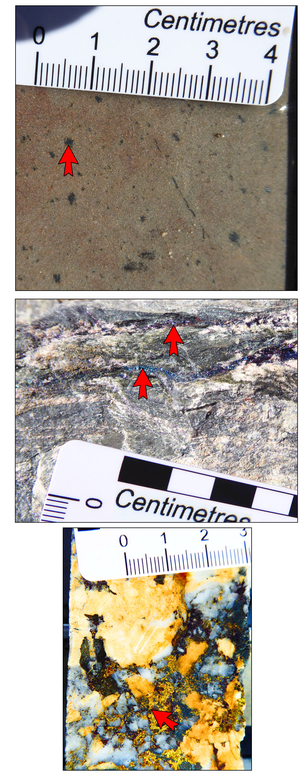
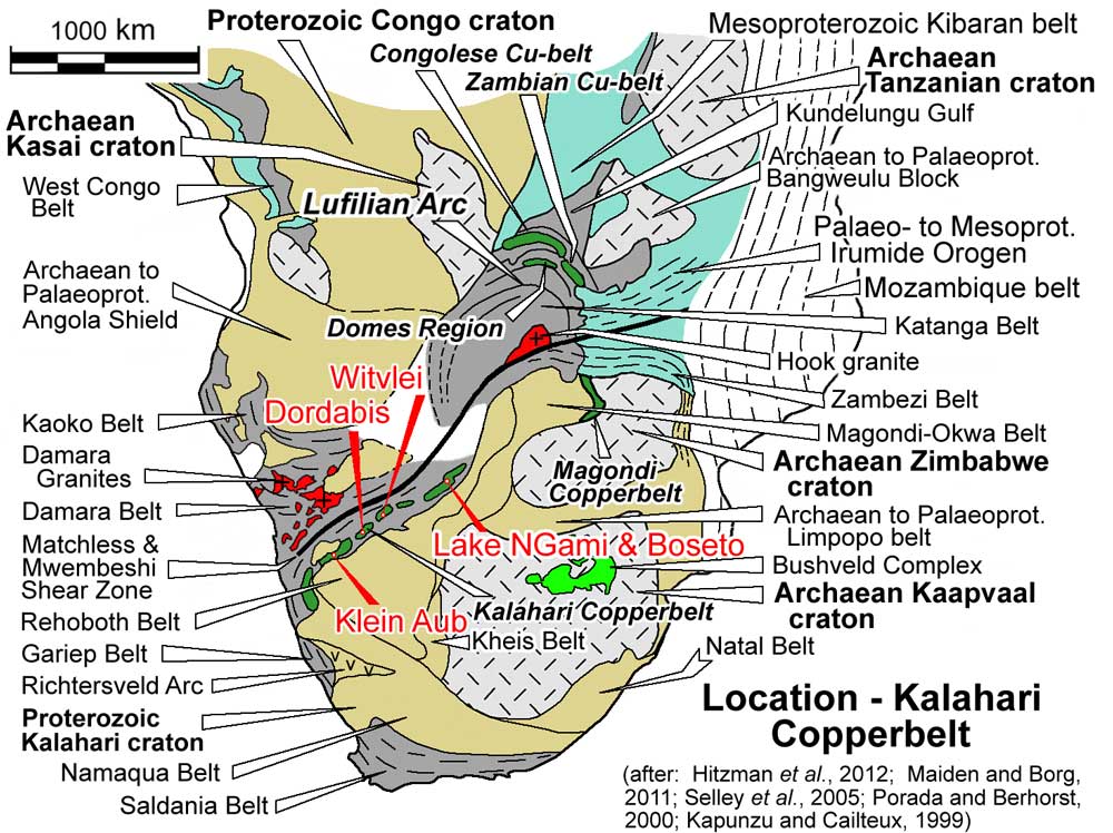
Ore styles - The three main ore styles of the deposits of the Kalahari Copper Belt in Botswana are illustrated by the images below from the Boseto deposit (described later in this record) i). Disseminations and blebs of sulphide (mainly bornite) in arenites (top image); ii). Veinlets of predominantly bornite in more argillaceous rocks, following both bedding planes and fractures (centre image) - note the two main 1 to 2 mm thick veins extending from left to right in the upper half of the image; and iii). Late quartz-carbonate veins with mainly chalcopyrite and pyrite (lower image) - note the irregular bright, 1 to 10 mm aggregates and stringers of yellow sulphides in the lower half of the image, interstitial to the blue-grey quartz and yellow to brown to white carbonate minerals. Photographs by Mike Porter, 2014.
Ghanzi Deposits
Mineralisation is distributed over a strike interval of up to 150 km and occurs within a thickness of up to 30 m above the contact between finely laminated and chemically reduced mudstones and siltstones of the D'Kar Formation and the underlying oxidised arkoses and sandstones of the Ngwako Pan Formation. The main resources is in an elongated, doubly plunging antiform, the Banana Zone, named for the shape of its outline at surface. The stratigraphy of this ~30 m zone in the lower D'Kar Formation, above the contact, is as follows, from the base:
Lower Marl unit - interbedded siltstone and laminated marls;
Rhythmite unit - alternating fining-upwards cycles of sandstone and siltstone;
Marker sandstone unit - massive medium grained sandstones and lithic arenites;
Alternating units - interbedded sandstones and siltstones;
Calc-arenite unit - interbedded carbonate-rich sandstones, lithic arenites, marls and subordinate carbonate-rich arenites;
Carbon-rich siltstone unit - black carbon-rich fine grained siltstones and shales;
The copper-silver mineralisation, typically occurs in three forms, frequently found together as:
i). Disseminated sulphides present as inter-granular clusters, or as aggregates distributed through porous sandstones, commonly in close association with, fractures and quartz, or quartz-carbonate veins. Regardless of the mineral zonation or sulphide assemblage, this style is generally fine grained and inter-granular, filling void spaces or replacing the original matrix or cement within porous sandstone units, to form a spotty texture. The highest concentration of clusters and aggregates are generally at the bedding interface between sandstone and overlying siltstones or shales, and in close proximity to structural features. It may occur in both the D'Kar and Ngwako Pan Formations, frequently in reduced, porous, carbonate rich facies;
ii). Cleavage related mineralisation - fine grained sulphides, concentrated along cleavage planes in non-porous siltstones and sandstones and as films coating fracture surfaces. This style is predominantly hosted by the finer siltstones and shales of the D'Kar Formation, but are also found in some finer grained sandstones of the same formation where aggregated grains and clusters form alignments parallel to the cleavage trace. The sulphide aggregates are stretched and transposed into the cleavage planes in all lithologies;
iii). Vein related mineralisation - that occurs in both the D'Kar and Ngwako Pan Formations, and comprises coarse grained sulphides in quartz and quartz-carbonate veins and veinlets, which may also contain K-feldspar, chlorite and sericite, and very rarely barite. The quartz of this stage of veining appears to be massive and translucent, in contrast to the early phase metamorphic quartz which is normally fibrous. Veins are generally 0.5 to 5 cm thick, although rare, larger veins may be up to several metres wide. Fractures, veins and veinlets sometimes increase in density towards the tops and/or bottoms of enclosing lithological units due to rheological contrasts. The highest grades for both Cu and Ag generally coincide with the highest density of structurally controlled veining, which frequently is within marls, especially the lower marl unit, and the black carbon rich siltstone and shale unit of the D'Kar Formation, where vein density typically ranges from 1 to 5 per metre. The lowest vein densities are within the sandstone lithologies of the D'Kar and Ngwako Pan Formations, except in the North East Fold, where a combination of a plunging fold closure and coincident faulting and thrusting has stimulated micro-faulting. Disseminated mineralisation commonly forms haloes adjacent to veins, or extends between fractures which are multidirectional, with interconnected bedding parallel and transgressive orientations, frequently forming stockworks. Sulphide stringers cross-cut the quartz and quartz-carbonate veins. Quartz and quartz-carbonate veining is widely developed, both stratigraphically above and below the main zones of mineralisation, where sulphide minerals are rare, presumably due to a lack of effective reductants available to facilitate precipitation, or depletion of metals from the mineralising fluids.
The sulphide assemblages within the Banana Zone are frequently zoned, mostly vertically upwards through the stratigraphic sequence but locally, laterally along strike and possibly up and down dip. This zonation is also influenced by local changes in the oxidation state, chemical characteristics of the lithologies, or the presence of other mobile reductants, and generally comprises; proximal hematite to chalcocite-hematite to chalcocite-bornite to bornite to bornite-chalcopyrite to chalcopyrite to chalcopyrite-pyrite to pyrite-sphalerite-galena.
On a deposit scale, the zonation is expressed as:
i). An upper, distal zone/sulphide assemblage largely devoid of copper-silver mineralisation but containing pyrite-sphalerite-galena usually related to fractures and veins. Beyond this zone, quartz and quartz-carbonate veins predominate and are sulphide free, although pyrite occasionally occurs as coatings on fracture surfaces;
ii). A middle zone/sulphide assemblage, from the base upward of bornite and chalcopyrite, to chalcopyrite and finally chalcopyrite-pyrite, all of which occur equally as disseminations, cleavages, fractures and veins;
iii). A lower, proximal zone of chalcocite or chalcocite-bornite occurring as coarse sulphides in veins and finer clusters and aggregates in fractures, along cleavage planes or disseminated through the porous lithologies.
Irrespective of the zoning pattern or composition of the sulphide assemblage, the structurally related cleavage or vein hosted and disseminated assemblages have the same textures, namely, chalcopyrite, progressively rimmed by bornite and then by chalcocite.
Published mineral resources in February 2012 (Caterall et al., 2012, technical report to Hana Mining Ltd) at a 0.4% (and 0.8%) Cu cut-offs respectively, were:
Banana Zone - New Discovery, North Limb North, North East Fold and South Limb Definition Subzones
Indicated resource - 40.9 Mt @ 0.87% Cu, 12.5 g/t Ag, (15.9 Mt @ 1.35% Cu, 20.2 g/t Ag);
Banana Zone - Chalcocite Subzone
Inferred resource - 190.9 Mt @ 0.60% Cu, 7.1 g/t Ag, (31.8 Mt @ 1.00% Cu, 12.5 g/t Ag);
Zone 5 (60 km NE of the Banana Zone, not the same as the Cupric Canyon Capital Zone 5 described below)
Inferred resource - 16.0 Mt @ 1.47% Cu, 13.2 g/t Ag, (14.9 Mt @ 1.57% Cu, 13.8 g/t Ag);
Boseto and Zone 5 Deposits
The Boseto deposits, which include Zeta, Plutus, Petra, Ophion, Selene, Zeta NE, NE Mango and others are located within 20 km to the NW of the Ghanzi Deposits, in similarly NE-SW trending host rocks at the same stratigraphic position, namely within finely laminated and chemically reduced mudstones and siltstones in the lower sections of the D'Kar Formation, immediately above the contact with the underlying oxidised arkoses and sandstones of the Ngwako Pan Formation.
The Boseto group of deposits are located in three parallel exposures of the host unit on the limbs of an adjacent, NE-SW trending, attenuated anticline-syncline pair. Petra and Plutus are on the northern limb of the anticline, distributed over a strike length of ~15 km. The Nexus deposit is distributed over the southern shared limb of the anticline and syncline, ~7 km to the SE, while Zeta and Zeta NE are on the southern limb of the syncline, ~2 km further to the SE. The limbs of these structures dip at 50 to 70°.
Copper in the Boseto Project area occurs predominantly in chalcocite, with minor amounts of bornite and other copper sulphides. At shallow depths, malachite and chrysocolla exist in significant proportions within some areas of the mineral resource.
Published mineral resources and ore reserves at 22 July 2013 (Discovery Metals Limited, 2013) were at cut-off grades in open pit of 0.5% Cu in fresh rock, 0.7% Cu in transitional material, and 1.0% Cu in oxide; and underground cut-off grade of 1.07% Cu equivalent and a 5 m minimum mining width:
Zeta Deposit
Proved + Probable open pit reserve - 1.8 Mt @ 1.3% Cu, 20 g/t Ag;
Proved + Probable underground reserve - 7.3 Mt @ 1.3% Cu, 23 g/t Ag;
TOTAL Ore Reserve - 9.0 Mt @ 1.3% Cu, 22 g/t Ag;
Measured + Indicated resource - 10.3 Mt @ 1.4% Cu, 24 g/t Ag;
Inferred resource - 8.5 Mt @ 1.7% Cu, 25 g/t Ag;
TOTAL Mineral Resource - 18.8 Mt @ 1.5% Cu, 24 g/t Ag.
Plutus Deposit
TOTAL Proved + Probable open pit reserve - 6.0 Mt @ 1.2% Cu, 12 g/t Ag;
Measured + Indicated resource - 18.5 Mt @ 1.3% Cu, 13 g/t Ag;
Inferred resource - 63.6 Mt @ 1.4% Cu, 12 g/t Ag;
TOTAL Mineral Resource - 82.1 Mt @ 1.3% Cu, 12 g/t Ag;
Zeta + Plutus Deposits
TOTAL Ore Reserve - 15.0 Mt @ 1.3% Cu, 18 g/t Ag.
TOTAL Mineral Resource - 100.9 Mt @ 1.4% Cu, 14 g/t Ag.
Other Deposits
Selene - Inferred resource - 16.0 Mt @ 1.0% Cu, 16.0 g/t Ag;
Zeta NE - Inferred resource - 12.9 Mt @ 1.3% Cu, 22.0 g/t Ag;
Ophion - Inferred resource - 14.0 Mt @ 1.0% Cu, 12.0 g/t Ag;
NE Mango 1 - Inferred resource - 4.8 Mt @ 1.2% Cu, 13 g/t Ag;
NE Mango 2 - Inferred resource - 28.5 Mt @ 1.3% Cu, 14.0 g/t Ag;
TOTAL Mineral Resource - 76.2 Mt @ 1.2% Cu, 15 g/t Ag.
Total mineral resources, all Boseto deposits as listed above - 177.1 Mt @ 1.3% Cu, 15 g/t Ag.
(Total mineral resources, all deposits in 2012 at a 0.6% Cu cut-off, was - 207.2 Mt @ 1.3% Cu, 16 g/t Ag.)
The Discovery Metals Limited Boseto mine closed in 2015, and was purchased by Cupric Canyon Capital to be amalgamated with that company's adjacent Khoemacau property. Subsequent exploration of the Mango NE prospect led to the delineation of additional and higher grade resources that became Zone 5 as described below.
The Zone 5 deposit of Cupric Canyon Capital lies ~12 km SE of the Zeta deposit, and is in the same trend and adjacent to the NE Mango mineralisation listed above. As in the other deposits, stratabound Cu-Ag mineralisation is hosted in the lower D'Kar and uppermost underlying Ngwako Pan Formation. The hanging wall-footwall redox contact between these two units is a distinctive target horizon that consistently hosts Cu-Ag mineralisation. The succession in the deposit area comprises an upward sequence from the sandstones of the Ngwako Pan Formation to the lower marl marker units, followed by calcareous shales to limestone with disseminated bornite and chalcocite, then the main high grade sulphide-bearing zone with >1% Cu overlain by a zone of weak pyrite-sphalerite-galena, further sandstone, and the D'Kar Formation siltstone with interbedded carbonaceous siltstone lenses. This sequence, which represents a thickness of ~150 m, dips at 55 to 60°SE. The main mineralised zone has a strike length of ~4.2 km and has been delineated down dip to an unclosed vertical depth of ~600 m, and average thickness of 9 to 10 m. Mineralisation has been traced to depths of >1200 m. It is masked by 2 to 60 m of Tertiary age Kalahari Group sands. The resource is amenable to both open pit and underground extraction.
Sulphide resources outlined at Zone 5 deposit to the end of 2017 at a 1.0% Cu cut-off (Cupric Canyon Capital website, viewed August, 2018) were:
Measured + Indicated resource - 43.4 Mt @ 2.02% Cu, 19.5 g/t Ag;
Inferred resource - 56.9 Mt @ 1.90% Cu, 20.2 g/t Ag;
TOTAL Mineral Resource - 100.3 Mt @ 1.95% Cu, 19.9 g/t Ag.
Revised Mineral Resources for an amalgamation of the resources above by Khoemacau Copper Mining as of June 2021 (Khoemacau website viewed August, 2022) were:
Measured + Indicated + Inferred Mineral Resources
Zone 5 in situ sulphides - 16.3 Mt @ 2.4% Cu, 22.1 g/t Ag;
Zone 5 stockpiles - 0.3 Mt @ 2.0% Cu, 21.3 g/t Ag;
Zeta NE - 29.0 Mt @ 2.0% Cu, 39.7 g/t Ag;
Zone 5 North - 25.6 Mt @ 2.2% Cu, 38.0 g/t Ag;
Mango NE - 21.1 Mt @ 1.8% Cu, 21.3 g/t Ag;
Banana and others - 335.4 Mt @ 1.0% Cu, 11.7 g/t Ag;
TOTAL - 503.9 Mt @ 1.4% Cu, 17.0 g/t Ag.
T3 and T20 Domes
The broad T3 and T20 dome areas are located to the SW of Boseto and cover WSW trending strike lengths of 60 and 40 km respectively in the interval between Boseto and the Botswana-Namibian border. The centre of the T3 dome is ~100 km SW of Boseto, while the centre of T20 is another 100 km to the WSW again. The T3 Dome is immediately to the WSW of the Banana Dome/Zone described in the Ghanzi Deposits section above. These domes all lie within a WSW trending, 15 to 25 km wide structural corridor which MOD Resources and Tshukudu Metals refers to as the Mahumo Structural Corridor. However, they generally have shallowly dipping limbs and are largely masked by superficial cover. The T3 deposit was indicated by a 28 ppm Cu calcrete anomaly, which was followed up with an intersection of 52 m @ 2.0% Cu from 76 m depth. This mineralised zone dips at ~30%°N. It comprises vein, brecciated and disseminated sulphides within a siltstone/mudstone host and as veinlets and disseminations in underlying sandstones. The mineralised zone lies on and just above the contact between the underlying arenaceous Ngwako Pan Formation and the overlying finer clastic rocks of the D'Kar Formation. The transition between the two units commences with the appearance of marl interbeds which provide a marker unit. There is a downward sulphide zonation from chalcopyrite → bornite → chalcocite in the main mineralised sheet, while broad, but variably developed bands of disseminated and veinlet bornite±chalcocite occur 0 to 75 m below in the sandstone with intersections of up to 72 m @ 1.5% Cu, 27 g/t Ag and 13 m @ 1% Cu, 18 g/t Ag 200 m along strike. The localisation of the upper mineralised zone apparently has a strong structural association with shallow thrusting above or near the sandstone-siltstone contact.
Published JORC compliant Mineral Resources for the T3 deposit at 16 July 2018 (MOD Resources Ltd website viewed August 2018) were at cut-off grades in open pit of 0.4% Cu:
Indicated resource - 36.631 Mt @ 1.14% Cu, 16 g/t Ag;
Inferred resource - 23.524 Mt @ 0.74% Cu, 11 g/t Ag;
TOTAL resource - 60.155 Mt @ 0.98% Cu, 14 g/t Ag.
Motheo Mine
Construction commenced on the Motheo Mine in 2020 to exploit the T3 and satellite deposits of the T3 Dome as described above, with production planned to come on-stream in 2023 as a 5.2 Mtpa open pit operation (Sandfire Resources Annual Report, 2021). The Motheo Copper Mine and treatment plant is to be a hub to the main T3 and surrounding deposits. The satellite deposits include A4, which is 8 km west of the MotheoMine.
The geology of the A4 deposit is as follows (from Sandfire Resources ASX Release, 22 September, 2021). As with the other deposits of the Ghanzi-Chobe belt in western Botswana (including T3), the stratigraphy comprises the basal Kgwebe Volcanics which are unconformably overlain by Ghanzi Group sediments. There is no outcrop of the Ghanzi Group within the A4 project area, as the host meta-sediments are locally covered with a shallow layer of superficial calcrete, sand and soil. The A4 deposit occupies a similar structural and stratigraphic position to that of the T3 Deposit in that it occurs within a NE-SW trending periclinal anticline, the A4 Dome, which has a core of Ngwako Pan Formation sandstone, overlain by a succession of D'Kar Formation shale, sandstone, siltstone and carbonates. All known mineralisation lies within the D'Kar Formation. Second order parasitic upright to overturned folds are developed within the axial region of the periclinal anticline. These second order folds are cross-cut and displaced by moderately NW dipping brittle-ductile, reverse shear zones that are characterised by zones of heterogeneous foliation of variable width and intensity. High strain zones have been recognised along which different sedimentary units have been juxtaposed by brittle displacement. Flat-lying to shallow-dipping zones of extensional fracturing and veining are developed in the footwall of the main shear zone. These extensional zones are interpreted to have formed as shear related extensional structures during thrusting. The extensional structures are preferentially developed within a sandstone dominated package but also penetrate into the overlying carbonate and siltstone dominated units.
Copper-silver mineralisation is developed along both the shear and the extensional zones. Within the shear zones, bornite, chalcocite and chalcopyrite are associated with quartz-carbonate veining developed sub-parallel to the shear foliation, whilst in the extensional zones, copper sulphides occur within either quartz-carbonate veins or as sulphide fill to in-situ fragmentation breccia zones within the host sediments. Mineralisation has been traced over a strike length of ~900 m and 270 m down-dip, remaining open both at depth and along strike. A nominal 0.3% Cu cut-off grade has been used to determine the external boundary of the mineralised zones. Immediately above the mineralised zone, soil/sand and calcrete extends to a depth ranging from 3 to 8 m. Saprolite representing >25% oxidation, extends from 25 to 60 m below surface whilst saprock with 1 to 25% oxidation persists from 55 to 85 m depth. Where oxidised, primary copper sulphides are altered to malachite, chrysocolla or covellite.
T3 Deposit Open Pit - JORC compliant Ore Reserve and Mineral Resource as at 1 December 2020 (Sandfire Resources Annual Report, 2021) were:
Indicated + Inferred Mineral Resources - 48.8 Mt @ 0.92% Cu, 12.5 g/t Ag (including an Inferred Resource of 4.5 Mt @ 0.74% Cu, 14.7 g/t Ag);
Probable Ore Reserves - 39.9 Mt @ 0.90% Cu, 12.2 g/t Ag.
NOTE: Mineral Resources are inclusive of Ore Reserves.
A4 Deposit, JORC compliant Mineral Resources at July, 2021 (Sandfire Resources ASX Release, 22 September, 2021) were:
Indicated + Inferred Mineral Resources - 9.820 Mt @ 1.4% Cu, 21 g/t Ag, in which the Indicated Resource was broken down into,
Saprolite - 0.55 Mt @ 1.0% Cu, 7.0 g/t Ag;
Saprock - 1.34 Mt @ 1.5% Cu, 14.0 g/t Ag;
Fresh - 7.0 Mt @ 1.4% Cu, 24.0 g/t Ag;
TOTAL - 8.9 Mt @ 1.4% Cu, 21.0 g/t Ag.
The most recent source geological information used to prepare this decription was dated: 2021.
Record last updated: 23/8/2022
This description is a summary from published sources, the chief of which are listed below.
© Copyright Porter GeoConsultancy Pty Ltd. Unauthorised copying, reproduction, storage or dissemination prohibited.
|
|
|
|
|
Catterall D, Grant J, Meister S N, Obiri-Yeboa T, Cresswell M and Channon W, 2012 - Ghanzi Copper-Silver Project, Ghanzi District, Botswana (selected excerpts): in NI 43-101 Technical Report, Prepared for Hana Mining Ltd, www.sedar.com, pp. 1-4, 20-32
|
Hall, W.S., Stein, H.J., Kylander-Clark, A.R.C., Hitzman, M.W., Kuiper, Y.D., Knight, C. and Enders, M.S., 2021 - Diagenetic and Epigenetic Mineralizing Events in the Kalahari Copperbelt, Botswana: Evidence from Re-Os Sulfide Dating and U-Th-Pb Xenotime Geochronology: in Econ. Geol. v.116, pp. 863-881.
|
Modie B N, 2000 - Geology and mineralisation in the Meso- to Neoproterozoic Ghanzi-Chobe Belt of northwest Botswana: in J. of African Earth Sciences v.30 pp. 467-474
|
Modies B N, 1996 - Depositional environments of the Meso- to Neoproterozoic Ghanzi-Chobe belt, northwest Botswana: in J. of African Earth Sciences v.22 pp. 255-268
|
|
Porter GeoConsultancy Pty Ltd (PorterGeo) provides access to this database at no charge. It is largely based on scientific papers and reports in the public domain, and was current when the sources consulted were published. While PorterGeo endeavour to ensure the information was accurate at the time of compilation and subsequent updating, PorterGeo, its employees and servants: i). do not warrant, or make any representation regarding the use, or results of the use of the information contained herein as to its correctness, accuracy, currency, or otherwise; and ii). expressly disclaim all liability or responsibility to any person using the information or conclusions contained herein.
|
Top | Search Again | PGC Home | Terms & Conditions
|
|


