|
Diamond Districts and kimberlites of the Atlantic Shield - Brauna, Salvador, Canastra, Catalao, Moana, Chapada, Diamantina, Romaria, Coromandel, Duas Barras, Quilombo, Alto Paranaiba Arch, Nortelandia, Paranatinga, Rio das Garcas, Rio Araguaia |
|
|
Brazil |
| Main commodities:
Diamonds
|
|
 |
|
|
 |
Super Porphyry Cu and Au


|
IOCG Deposits - 70 papers
|
All papers now Open Access.
Available as Full Text for direct download or on request. |
|
|
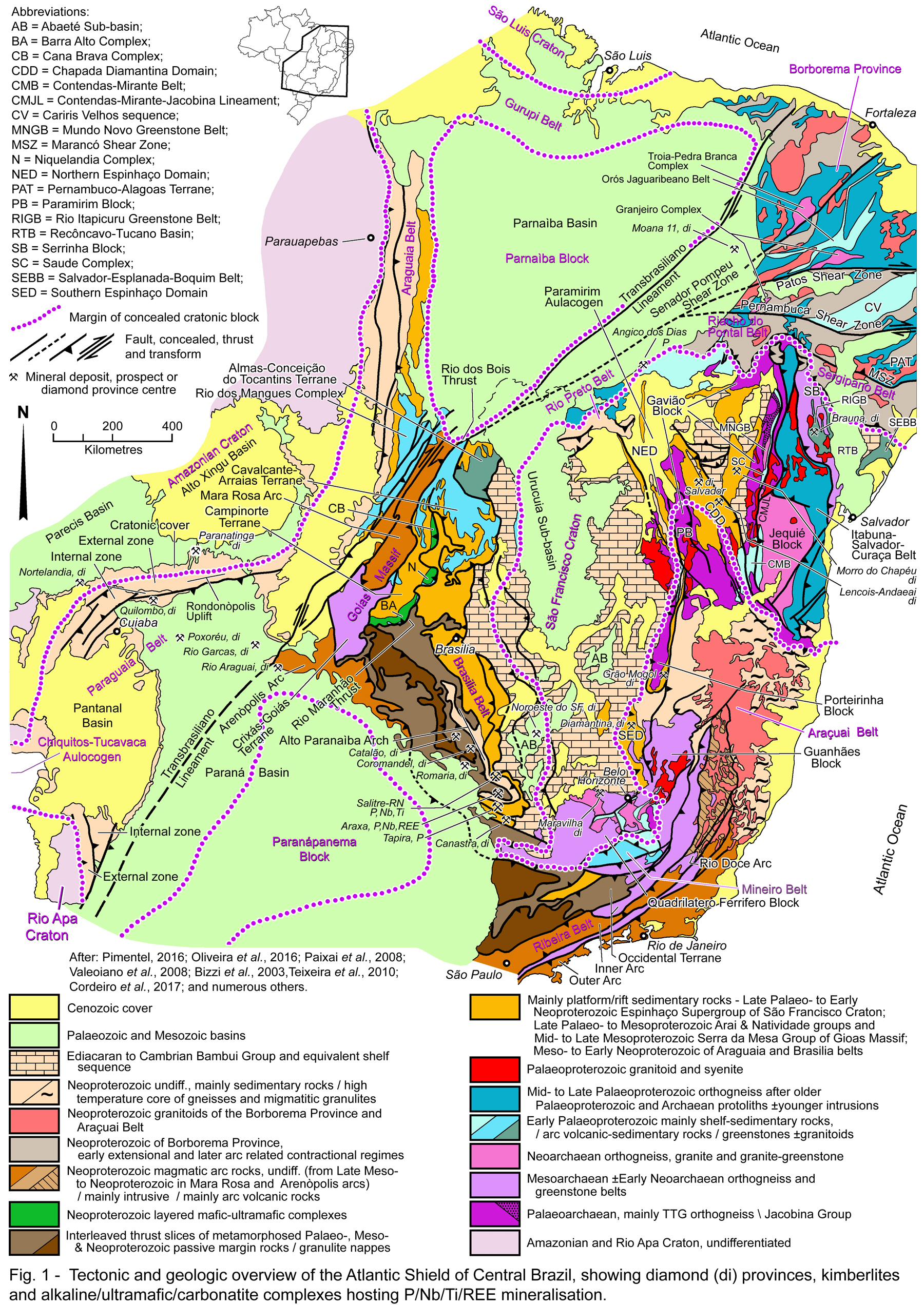
Diamonds have been produced over a wide area within the Atlantic Shield of Brazil. Whilst one primary kimberlite hosted deposit has been mined, the bulk of production has been from recent alluvial accumulations derived from secondary sources. Those secondary sources comprise sedimentary units, usually coarse clastics and conglomerates or diamictites, of Mesoproterozoic, Neoproterozoic, Permo-Carboniferous or Cretaceous age, some of which have grades that are sufficiently high, and/or are strongly weathered and 'soft'. The Upper Cretaceous units, however, contain voluminous lava flows and volcaniclastic units that are temporally and compositionally equivalent to kimberlites intruding the same sequence. More than a thousand kimberlitic intrusions have been found throughout the shield, although only ~20 have been shown to be diamondiferous. These vary in age with individual intrusions or clusters emplaced at ~1152, 640, 235 to 216, ~120 and 98 to 74 Ma. The great majority of diamond production in Brazil has been from artisanal mining, with only a few larger scale operations.
Summary and Index
The principal deposits, and diamondiferous provinces/districts within the Atlantic Shield of Brazil are the:
• Northern São Francisco Craton and Diamantina District - which includes the 640 Ma Braúna kimberlite; the 1152 Ma Salvador kimberlite and alluvial deposits of the Chapada Diamantina; The Diamantina District in the Southern Espinhaço Domain and the Duas Barras deposit; and the diamondiferous Sopa-Brumadinho and Tombador formations of the Mesoproterozoic Espinhaço Supergroup that are secondary sources of diamonds, but have also locally been mined where sufficiently rich and/or soft.
• Alto Paranaíba Arch - that hosts the most prolific occurrence of both kimberlitic intrusions and placer diamond mining, covering an area of ~400 x 150 km along axis of the NW-SE trending Lower Cretaceous Alto Paranaíba Arch. This arch is located on the southeastern flank of the Brasilia Belt and São Francisco Craton, opposite the Paranápanema Block (Fig. 1). The province has been divided into 11 'kimberlite fields', the most prolific of which is the Coromandel ‐ Três Ranchos Kimberlite Field which contains >580 'kimberlitic' intrusions. Of these, diamonds have only been recovered from ~18 separate intrusions, although most grades and tonnages are sub-economic. The most significant diamondiferous kimberlites along the arch are the 95 to 82 Ma Catalão and 120 Ma Canastra clusters to the NW and SE respectively.
The Coromandel alluvial district, which largely corresponds to the Coromandel ‐ Três Ranchos Kimberlite Field, has produced at least 40 million carats of alluvial diamonds in accumulations interpreted to have been derived from Cretaceous secondary sources in the São Franciscana and Paraná basins that flank the arch. Diamonds have been mined directly from the secondary volcano-sedimentary source at the historic Romaria mine. Other smaller alluvial diamonds fields are found along the arch.
• Noroeste do São Francisco Province, located ~100 km east of the Alto Paranaíba Diamond Province. It overlies Mesozoics and Permo-Carboniferous rocks of the São Franciscana Basin and the Neoproterozoic to Cambrian Bambuí Group on the margin of the structurally underlying São Francisco Craton. All three of these cover sequences are potential secondary diamond sources. No 'kimberlitic' intrusions are known within the province.
• Paraguaia Belt exposed in the Rondonópolis Uplift, and the flanking Paraná and Parecis basins, which includes the:
- Chapada dos Guimarães/Quilombo Diamond Province, which straddles the external and internal facies of the Paraguaia Belt and the Paraná Basin to the south, and is a producer of alluvial diamonds;
- Poxoréu Diamond Province, which is entirely underlain by Cretaceous rocks of the Paraná Basin and also embraces alluvial diamond deposits, without any accompanying diamondiferous kimberlite intrusions;
- Nortelândia-Diamantino Diamond Province, which straddles the external zone of the exposed Paraguaia Fold Belt, and the Parecis Basin to the north, which overlies the Amazonia Craton. This province is extensively mined for alluvial diamonds;
- Paranatinga Diamond Province which also straddles the external zone of the exposed Paraguaia Fold Belt and both the Palaeozoic to Mesozoic Parecis and overlying Cenozoic Alto Xingu basins, all of which overlie the Amazonia Craton. This province also includes Cretaceous diamondiferous kimberlites as well as alluvial diamond accumulations.
• Provinces straddling the Transbrasiliano Lineament, and overlying the Paraná Basin and older basement - the contiguous Rio das Garças and Rio Araguaia diamond provinces are found to the NW and SE of the lineament, respectively. Both host alluvial diamond mines, while the Rio Araguaia Province is intruded by a cluster of barren Cretaceous kimberlites, predominantly downstream of the alluvial diamondiferous alluvial accumulations.
• Kimberlites in the Parnaiba Basin, above the Borborema Province in Piauí, defined by the >40 kimberlitic intrusions of the Moana Diamond Province, one of which is diamondiferous.
 Click here to expand
Diamonds were first discovered in Brazil in the early 1700s by artisinal miners prospecting for gold along the banks of the Jequitinhonha River in northern Minas Gerais, near the village of Arraial do Tijuco, subsequently renamed Diamantina. This became the centre of the Diamantina placer diamond field in the Southern Espinhaço Domain (Fig. 1). From 1730 until 1871, Brazil produced between 50 000 and 250 000 carats per year, and was the world's major supplier of gem diamonds, most of which came from Minas Gerais. However, the discovery of the richer Kimberley kimberlite in South Africa in 1869 led to the collapse of the Brazilian diamond industry. Production recovered when diamonds were found in other Brazilian states in the 19th and 20th centuries. By the early 1970s, it was ~300 000 carats per annum, before jumping to 670 000 carats in 1980, due to discovery of the Juína deposits to the west, in the Amazonian Craton in Mato Grosso. More recently, production has declined to <32 000 carats in 2015, but is expected to increase significantly with the commencement of mining of the Braúna 3 kimberlite in Bahia.
The great bulk of Brazilian production has been from tertiary alluvial placer deposits derived from erosion of secondary diamond bearing palaeo-placer accumulations that range from Palaeoproterozoic to Cretaceous in age. To at least the year 2000, only one lithified deposit had been commercially exploited, the historic Romaria mine in western Minas Gerais (Fig. 1). This mine produced diamonds from 1867 to 1984. However, minor production has also been derived from another of these secondary, lithified sources, the Mesoproterozoic meta-conglomerates of the Sopa-Brumadinho Formation (of the Espinhaço Supergroup) in the Diamantina region. The diamondiferous host at Romaria was a Cretaceous coarse polymictic conglomerate, which locally resembles kimberlitic epiclastic facies, suggesting it was close to a primary kimberlitic source.
The unconsolidated alluvial accumulations have historically been mined by garimpeiros (artisanal miners), with the country's official production being one million carats per annum in 1995 (Svisero, 1995). To 2000, commercially viable mechanised mining utilising dredges had only been undertaken in the Jequitinhonha River at Diamantina in Minas Gerais (Fig. 1), and at Camargo in the Nortelandia District, NW of Cuiaba in Mato Grosso (Fig. 1).
Extensive lithified secondary diamond bearing sequences occur within the late Palaeo- to early Neoproterozoic Espinhaço Supergroup, deposited on the São Francisco Craton and its margins, and preserved in the Southern Espinhaço Domain (SED), Northern Espinhaço Domain (NED) and both arms of the 'V - shaped' Chapada Diamantina Domain (CDD; Fig. 1) to the NE. The principal secondary diamondiferous unit within the Espinhaço Supergroup in the Southern Espinhaço Domain (SED) in Minas Gerais, is the Sopa-Brumadinho Formation which belongs to the Diamantina Group (Dossin et al., 1990). This formation has maximum sedimentation ages ranging from 1.35 to 1.05 Ga (Chemale Jr. et al., 2012; Chaves et al., 2012; Chaves et al., 2013) and has been metamorphosed to greenschist facies. It comprises a sedimentary package that has a composite thickness of 2 to 15 m and great continuity. It is composed of at least five horizons of meta-conglomerates with rounded clasts that are tens of centimetres in diameter, mainly of quartzites, quartz, phyllites, conglomerates, schists, acidic volcanics and itabirites, set in a thick matrix. These are separated by medium to coarse grained quartzites with plane-parallel and cross-channeled laminations, interspersed with phyllite bands (Dossin et al., 1990). The diamondiferous layers have concentrations ranging from 0.04 to 0.076 carats/m3. Sedimentation within the Sopa-Brumadinho Formation is regarded to have occurred along growth fault scarps in a rift environment, in a high-energy marine depositional environment, representing transitional sub-environments such as beaches and tidal flats, with a continental fluvial contribution (Almeida and Litwinki et al., 1984). However, it lacks kimberlite indicator minerals (Gonzaga and Thompkins, 1991). Some medium-sized mines were developed on the Sopa-Brumadinho conglomerates in the Diamantina region, the most significant being those at Datas, Boa Vista, Serrinha, Lavrinha, Perpétua, Barro, Pagão, Campo Sampaio and Jobô. Weathering and decomposition aided mining (Fleischer, 1995). Wherever streams cross the Sopa-Brumadinho conglomerates their alluvium is diamondiferous (Fleischer, 1995).
The principal secondary source to the north, in the Chapada Diamantina (CDD; Fig. 1) in Bahia, is from the meta-conglomerates of the Tombador Formation a member of the Mesoproterozoic Chapada Diamantina Group, which is, in turn, part of the Espinhaço Supergroup. Placer accumulations of diamonds from this sources were first mined from around 1842, when they were discovered in the Mucugê River. These diamonds are mostly colourless with lesser brown and grey stones, and have dodecahedral habits, or curved forms, intermediate between octahedral and dodecahedral. As in the Sopa-Brumadinho Formation in Minas Gerais, there are no kimberlite indicator minerals within the Tombador Formation.
In around 1841, it was realised that some dark grains in heavy mineral concentrates from the Chapada Diamantina had the same hardness as diamonds. These stones were recognised as a type of diamond with a marginally lower SG (3.51), lack of cleavage, but similar hardness, and greater toughness and resistance to impact, making them superior to other diamonds for industrial use. They are known as carbonados, and are a polycrystalline aggregate that is opaque and solid but porous, consisting of a mixture of diamond, graphite and amorphous carbon (Haggerty, 2014). They are generally ~1 cm in size, but occasionally are tens to hundreds of carats. The biggest is the 3167 carat Sérgio found near Lençóis in 1905, also the largest natural diamond ever found. The next largest was Casco de Burro, also found at Lençóis, but in 1906. Carbonados (or black diamonds) are important in Bahia, but also occur to a lesser degree elsewhere in Brazil, but are only found outside of the country in the Central African Republic.
Other significant secondary source sequences include the widespread diamictite members of both the Neoproterozoic Bambuí Group over the São Francisco Craton and the equivalent Macaúbas Group of the Araçuaí Orogen/Fold Belt to the east (CPRM, 2017). Mining, which yielding diamonds, including stones of up to 30 carats, are recorded in a drainage that cuts the Jequitaí Tillite/diamictite of the Macaúbas Group in the Macaúbas River basin (Nishimura et al., 1984; Schobbenhaus et al., 1984; Gonzaga and Thompkins, 1991). The Samburá Conglomerate of the Bambuí Group, which comprises granules, pebbles, blocks and boulders that are chaotically set in a grey-green silt/clay matrix that weathers to reddish. The most common clasts are quartzite, milky quartz, gneiss, phyllite, carbonate and red chert. The matrix is phosphate rich with ~5% of P2O5 (Gonzaga & Thompkins, 1991). This unit and its surrounds have been the focus of diamond prospecting since 1937, although no kimberlite indicator minerals have been found (Barbosa et al., 1970). Possible equivalent conglomerates in the Neoproterozoic Ibiá Group of the Brazilia Belt contain diamonds, as indicated by macro-diamonds of 110, 76, 40 and 23 carats found in gravels of the Sáo Francisco River located on top of the Ibiá Group, (Barbosa et al., 1970). This conglomerate is tens of metres thick and contains clasts of Canastra quartzite in a chaotic matrix, and is regarded to be a metamorphic equivalent of the Jequitaí Tillite/diamictite (Gonzaga & Thompkins, 1991).
The Permo-Carboniferous Santa F&ecute; Group in the Phanerozoic Abaeté (AB) and Urucuia (Fig, 1) sub-basins of the larger depository collectively known as the São Franciscana Basin, was deposited over the São Francisco Craton. It comprises a set of glaciogenic sediments, with a predominance of sandstones and a small volume of diamictites. This unit is interpreted to have been deposited in a fluvio‐glacial to glacial‐lacustrine and periglacial aeolian environment. The provenance of the sequence includes rocks of the Chapada Diamantina, Palaeoproterozoic Volcano-Sedimentary Sequences, Greenstone Belts, basement terrains and metadiamictites of the Macaúbas Group (CPRM, 2017).
Younger secondary source sequences are mainly of Cretaceous age, and include the Lower Cretaceous São Bento Group in the Paraná Basin, and the equivalent Areado Group in the Abaeté (AB) and Urucuia sub-basins over the São Francisco Craton. These are followed by the Upper Cretaceous Bauru Group of the Paraná Basin, and the equivalent Mata da Corda Group of the Abaeté/Urucuia sub-basins of the São Franciscana Basin. These two sequences lie on the southwestern and northeastern limbs of the regional, Late Cretaceous, NW-SE trending Alto Paranaíba Arch (Fig. 1). They are considered to be the source of the abundant alluvial diamond accumulations of the Coromandel and adjacent districts that extend along the axis of the arch for ~400 km, from the Catal&atão to the Canastra diamond occurrences in the NW and SE respectively (Fig. 1).
These Cretaceous sequences are also exposed along the northwestern margin of the Paran´ Basin, overlying the Paraguaia Belt on the southern flank of the Rondonópolis Uplift in Mato Grosso State, particularly in the Chapada dos Guimarãesb> (or Quilombo) and Poxoréu districts.
The Nortelândia and Paranatinga districts overlie the margin of the Amazonia Craton (Fig. 1) and the Cretaceous sequence of the Parecis Basin. Diamondiferous sedimentary rocks within the Parecis Basin are contained within the Upper Cretaceous Parecis Group, correlated with the Bauru and Mata da Corda groups.
NOTE: The diamond districts listed above, and shown on Fig. 1, cover a radius of ~50 to 100 km around, or upstream and downstream of the locations shown.
The first kimberlites were not recognised in Brazil until the late 1960s. More than a thousand have been since been located, mostly forming clusters within the known alluvial diamond fields, although only ~20 are diamondiferous, representing potential primary diamond sources. These will be discussed below by region and in relation to placer accumulations.
Northern São Francisco Craton and Diamantina District
Of the kimberlites found to date in the Atlantic Shield, only one, Braúna 3 kimberlite in northeastern Bahia has been commercially mined as of 2023. Twenty-two diamondiferous kimberlites have been discovered in the Braúna field, comprising three pipes, Braúna 03, 04 and 07, and 19 dyke systems. The kimberlite field at Braúna comprises a 15 km line of closely spaced intrusions in the south, and a sparsely populated cluster of another 8 spread over a NNE-SSW elongated area of ~135 x 45 km, 2 of which are diamondiferous. This cluster was intruded into the Palaeoproterozoic Rio Itapicuru Greenstone Belt (RIGB; Fig. 1), in the centre of the Serrinha Block (SB; Fig. 1), and has been dated at 642 ±6 Ma (U/Pb, perovskite; CPRM, 2017) and 682 ±20 Ma (Pisani et al., 2001). Braúna 3 has a grade of ~45 carats of diamonds per hundred tonnes (SRK Consulting 2014).
The diamondiferous Salvador 1 kimberlite was discovered in 1991, covered by eluvial sediments in an area of inactive mining known as Canoão. It is located near the town of Minas do Espírito Santo in the municipality of Barra de Mendes in northwestern Bahia, and lies within the Chapada Diamantina Domain (CDD; Fig. 1). However, with a grade that is variously reported as 0.06 carats/m3 (Neto et al>, CPRM, 2017) or 6 carats per hundred tonnes of low gem quality diamonds (Cunha et al>, CPRM, 2017) it has been regarded as not being economically viable (Chaves et al., 2010). It is one of ~6 kimberlitic intrusions in two groups, distributed over a linear NW-SE interval of ~50 km. The other 5 are barren. Salvador 1, 2 and 3 to the SE intrude the diamondiferous meta-arenites and conglomerates of the Tombador Formation of the Palaeo- to Mesoproterozoic Espinhaço Supergroup. Salvador 1 has been dated at 1152 Ma (Rb/Sr), making it the oldest known kimberlitic intrusion in the Atlantic Shield. The other three intrusions, Conquista 1 and 2, and Bob-1, ~30 km to the NW, are covered by meta-arenites and meta-pelites of the Caboclo Formation, also of the Espinhaço Supergroup (Pereira and Fuck, 2005; Souza and Silva, 2010), with field relationships indicating they were intruded during the deposition of that formation. The Chapada Diamantina Domain contains widespread alluvial diamond fields distributed over a NNW-SSE length of >400 km on its western limb and to a lesser extent on the eastern arm, considerably more extensive than the known kimberlites, and are presumably derived from a secondary source in the Espinhaço Supergroup. The main concentration in the western arm is near the intersection of the two. Key districts include, from NNW to SSE, Palmeiras, Lençois, Andaeaí and Mucugê, and Morro de Chapéu in the centre of the eastern limb (CPRM, 2017).
No intrusions that have definitely been confirmed to be kimberlitic have been found in the Diamantina District in Minas Gerais. However, bodies with intrusive relationships with respect to the Espinhaço Supergroup country rocks, have been proposed to represent 'meta-kimberlitic' intrusions after kimberlite, lamproite or related protoliths, although this interpretation has been the subject of inconclusive 'fierce debate' for almost a century. The rocks are described as dark grey to greenish, mottled, hematite-sericite diamond-bearing phyllites, locally containing kaolinised porphyroblasts. Dating of zircons from these rocks gave ages of 1.70 to 1.72 Ga (U/Pb and Pb/Pb). Those against a kimberlitic origin note these rocks do not contain the normal suite of kimberlitic indicator minerals, nor the low silica, alumina and iron oxide, with high MgO and Na2O/K2O ratio. Conversely, some do contain and have been mined for diamonds, or are associated with placer diamond accumulations. Nine such intrusions have been identified in two clusters at either extremity of a 40 km, NNW-SSE trend, and have been designated Espinhaço 1 to 9. Five of these are diamondiferous. As in the Chapada Diamantina Domain, the placer diamond deposits are far more extensively developed than the proposed kimberlitic intrusions.
The Jequitinhonha River, which is the chief source of production in the Diamantina Region, has diamondiferous alluvium over most of its course, which in that region extends from close to its head in the municipality of Presidente Kubitschek, to Grão Mogol (Fig. 1), covering a length of ~350 km. Garimpos, disposed along all this section are mainly exploiting alluvial accumulations. The most important mines include Areinha, Capim Açu, Maria Nunes, Braúna, Lagoa da Pedra and Duas Barras.
The Duas Barras placer deposit (at the same location as Diamantina on Fig. 1), in the Diamantina district, is located on the outer side of a major bend in a palaeo-channel of the Jequitinhonha River. Recent alluvial and terrace deposits mostly overlie quartzites of the Duas Barras and Serra do Catuni Formations of the Espinhaço Supergroup. The surrounding hills are capped by laterite. The source of detritus is the Sopa do Brumadinho Formation, also of the Espinhaço Supergroup. The mineralised alluvium being worked is up to 300 m wide and extends along the river for ~1 km. The gravels comprise a lower white bimodal unit overlying the quartzite bedrock. It has a high sand content, enclosing cobbles and up to 700 mm boulders of quartz and quartzite. These are overlain by an upper yellow gravel which typically comprises rounded and sub-rounded cobbles of quartz and quartzite up to 100 mm in diameter, and sub-rounded boulders ranging up to 300 mm. These two gravel beds are typically 9 and 3 m thick respectively, and together, in some places, have an overall thickness of >20 m. They are typically covered by ~8 to 10 m of overburden, comprising red soils. The diamonds of the Jequitinhonha River are typically well-formed octahedral crystals with a good white colour, with the largest stone recovered just upstream of Duas Barras being 28 carats. A study of 186 052 diamonds (17 689 carats) from 14 production locations along the Jequitinhonha River gave a mean size of 0.095 ct/stone, with an average 82.2 % gem quality. NI 43-101 compliant Mineral Resources as of February 2010 (Vaaldiam Resources Ltd NI 43-101 Technical Report) was:
Indicated Resource - 1.5308 Mm3 @ 0.16 ct/m3 diamonds, 0.182 g/m3 Au, for 0.24493 million carats of diamonds and 0.279 tonnes of gold.
Inferred Resource - 0.8108 Mm3 @ 0.16 ct/m3 diamonds, 0.182 g/m3 Au, for 0.12973 carats of diamonds and 0.147 tonnes of gold.
Production commenced at Duas Barras in September 2007 but was suspended in October 2008, before a restart in 2010, continuing operations until at least 2017 before being suspended again.
Alto Paranaíba Arch
The most prolific occurrence of kimberlitic intrusions and placer diamond mining follows the NW-SE trending axis of the Lower Cretaceous Alto Paranaíba Arch (Fig. 1), on the southeastern flank of the Brasilia Belt and São Francisco Craton, opposite the Paranápanema Block. These alluvial accumulations and kimberlitic intrusions cover an area of ~400 x 150 km and includes 11 separate districts that extend from Catalão in the NW, to Canastra and Maravilha (Fig. 1) in the SE.
The greatest density of both kimberlites and alluvial occurrences over this interval is in the northern third, within the 160 x 150 km (11 600 km2) Coromandel Diamond District.
This district embraces >580 'kimberlitic' intrusions, referred to as the Coromandel ‐ Três Ranchos Kimberlite Field, and abundant alluvial diamond workings that have produced at least 40 million carats of diamonds (Neta et al., CPRM, 2017). This kimberlite field is, in turn, divided into a number of clusters, distinguished by their composition. There are ~68 such clusters, some of which extend into neighbouring districts. The largest of these is the Três Ranchos cluster, which comprises ~114 intrusions distributed over an area of ~50 x 30 km. The other 'clusters' vary from 1 to 4 closely space intrusions, to those with 5 to 30, generally spread over an area of ~15 to 25 km in diameter or length. However, of the total kimberlites within the Coromandel ‐ Três Ranchos Kimberlite Field, diamonds have only been recovered from ~18 separate intrusions. Of these, only 7 have been shown to have a significant size (i.e., >1 ha surface area). The area and diamond content/indication for each of these is as follows (Neta et al., CPRM, 2017):
- Limpeza 19, 49 ha - one 0.06 carat diamond recovered from an 83 m3 sample,
- Omega 1, 25 ha - 1 x micro-diamond recovered from a 160 kg sample,
- Guará 4, 9 ha - 1 x micro-diamond recovered from a 160 kg sample,
- Alpha 9, 8 ha - 2 x micro-diamonds recovered from a 160 kg sample,
- Delta 18, 8 ha - 1 x 0.02 carat micro-diamond recovered from a 54 kg sample,
- Alpha 4, 6 ha - 4 x micro-diamonds recovered from a 160 kg sample, and
- Santa Clara 1, 6 ha - 'positive result' for micro-diamonds,
The other 11 with positive diamond/micro-diamond recoveries generally have surface areas of <1 ha.
The absolute ages of 'kimberlitic' intrusions varies across the Coromandel ‐ Três Ranchos Kimberlite Field, from 98.7 ±2.1 Ma at Três Ranchos 78 in the NW, to 74.0 ±1.5 Ma at Sucesso 8 in the SE (Neta et al., CPRM, 2017).
The kimberlitic rocks of the field contain the principal kimberlite assemblage of picroilmenite, mantle garnets of peridotitic and/or eclogitic origin, Cr-spinel and clinopyroxene, although their distribution is zoned. There is a well-marked concentration of mantle garnets in the centre of the field, whilst on the margins, ilmenites and Cr-spinels predominate.
Immediately across the border to the north, in the Campo Alegre District of the State of Goias, the Catalão cluster of kimberlitic rocks includes a kimberlite pipe containing 23.5 carats of diamonds per hundred tonnes (Cunha et al., CPRM, 2017).
To the SE of the Coromandel Diamond District, the São Gotardo District contains the Sucesso cluster of kimberlitic intrusions which include (Neta et al., CPRM, 2017):
- Tucano 1, which yielded 182 x 0.003 carat micro-diamonds from a 66.9 kg bulk sample.
- Abel Regis 1, from which micro-diamonds have been recovered.
To the SE of the São Gotardo District, the Bambuí District embraces 66 small (mostly <1 ha) intrusions in numerous clusters which includes the diamondiferous Cana Verde 1 pipe, located north of the city of Luz (Neta et al., CPRM, 2017). Unike the Campo Alegre, Coromandel and São Gotardo districts, which overlie the Brasilia Belt, the Bambuí District is on the southern São Francisco Craton.
To the east of the Bambuí District, the Divinopólis District also incorporates numerous kimberlitic clusters, including the diamondiferous Maravilhas 3 pipe (Fig. 1) which covers an area of 0.3 ha and yielded seven microdiamonds totalling 0.123 carats from a 20 litre saprolite sample (Neta et al., CPRM, 2017). This pipe is also on the southern portion of the São Francisco Craton.
To the SW of the Bambuí Diamond District, the 3900 km2 Serra da Canastra Diamond District, which overlies the Brasilia Belt, is composed of 47 kimberlitic intrusions, ~half of which are pipes, the remainder being dykes or sills. Several kimberlite intrusions, including Canastra 1 and 3 occur mainly along the spine of the Canastra Range, cutting quartzites of the Canastra Group (Chaves et al., 2020). The most significant is Canastra 1, occurring as two pipe shaped 'blows', elongated east-west, with a composite area of 1.8 ha, and a grade that varies between 16 and 40 carats per hundred tonnes (Neta et al., CPRM, 2017). This intrusion has been dated at 120 ±10 Ma (K/Ar in flogopite; Pereira and Fuck, 2005) in the Lower Cretaceous. The Canastra Range is some 50 to 60 km west of the east vergent thrust faulted boundary between the Archaean basement Pium-hí Group and the structurally overlying Neoproterozoic Bambuí Group (Chaves et al., 2020). However, Pires (1984) argued that the actual cratonic boundary would be farther to the west, structurally underlying the Canastra and Bambuí groups.
Within the Sudoeste de Minas Gerais District, which is west and NW of the Bambuí and Serra da Canastra districts respectively, diamonds and micro-diamonds have been reported associated with kimberlitic intrusions. This kimberlitic district is the second largest in Minas Gerais, with 96 known intrusions. Of those tested, only Joana 3 had a positive response, with a 0.04 carat micro-diamond. In addition, five micro-diamonds, totalling 0.2 carats have been recovered from alluvium downstream from Joana 2, 5 and 6, and from Joana 38, whilst a 0.01 carat stone was found in alluvium downstream of Divisa 1. However, a direct relationship to the intrusions has not been proved.
The other 4 districts distributed along the Alto Paranaíba Arch, namely, Patos de Minas, Serra do Salitre, Boa Esperança and Santa Juliana host numerous kimberlitic intrusions, but despite being located between those listed as diamondiferous above, are to date, all devoid of diamonds or micro-diamonds (Neta et al., CPRM, 2017).
The 'kimberlitic' intrusions in the Coromandel Diamond District, and the broader group of districts along the Alto Paranaíba Arch, as described above, comprise: i). 100 to 80 Ma kimberlites (with a few as old as 120 Ma), ii). 90 to 75 Ma kamafugites (an ultrapotassic alkaline ultramafic rock; which predominate) and iii). 91 to 71 Ma alkaline-carbonatitic complexes. These three phases are collectively known as the Alto Paranaíba Igneous Province. The alkaline-carbonatitic complexes include a number covering areas of up to 65 km2 of intrusive, carbonatite-bearing ultramafic complexes, namely,
Catalão I and II, just NW of the Catalão kimberlite pipe (Fig. 1) in southern Goiás,
Salitre I and II, hosted by the Salitre-Serra Negra alkaline complex (Fig. 1),
Araxá,
Tapira and
Rocinha in western Minas Gerais.
The Alto Paranaíba Arch separates the major 1.5 million km2 Paraná Basin to the SW, from the extensive São Franciscana basins to the NE (Fig. 1). The latter is collectively represented by the Urucuia Sub-basin and the preserved remnants of its southern uplifted and eroded continuation, the Abaeté Sub-basin (Fig. 1). The development of these basins was the result of the major extensional event that culminated in the opening of the South Atlantic Ocean, commencing during the Lower Cretaceous when the voluminous Paraná Basalts were extruded to the SE within the Paraná Basin causing down-warping. During the Upper Cretaceous, ongoing extension resulted in continued crustal attenuation/thinning and by the development of the arch between the two major basins, presumably accompanied by asthenospheric and deeper mantle upwelling. However, it should be noted that the crust subjected to Cretaceous attenuation and uplift had previously been substantially thickened through imbrication during the Neoproterozoic Brasiliano event orogenesis. The Cretaceous extension may well have triggered delamination of the underlying heavier lithospheric mantle, uplift/arching of detached lighter crust, followed by decompression melting of the sinking lithospheric mantle, and ascent of the resulting magma through the attenuated, fault weakened crust.
The Alto Paranaíba Igneous Province was developed during this Cretaceous attenuation and arching event, initially as intrusive pipes and dykes/sills. It also included voluminous, temporally equivalent, kamafugite lava flows and ultrapotassic/potassic, ultramafic/mafic, SiO2-undersaturated volcanic and volcaniclastic rocks (Sgarbi et al., 2001; Karfunkel et al., 2015). As such it is one of the world's most voluminous mafic potassic provinces, representing >15 000 km3 of magma (Gibson et al., 1995).
The diverse suite of kimberlites, madupitic olivine lamproite and kamafugitic intrusive and extrusive rocks of the Alto Paranaíba Igneous Province, all have variable geochemical characteristics that suggest they were derived from a heterogeneous mantle source, but restricted ranges of other isotopes with values intermediate between Group I and II South African kimberlites. TDM Nd isotope model ages of ~900 Ma, suggest the magmas were derived by the remobilisation of early Neoproterozoic lithospheric mantle that had since been enriched by small-volume K-rich melt fractions (Gibson et al., 1995).
Alternatively, Gibson et al. (1995) suggest the Alto Paranaíba Arch and Igneous Province are the product of melting of the base of the lithospheric mantle by an eastward migrating mantle plume.
The Alto Paranaíba Arch also coincides with the continental scale, 125° trending AZ 125 Lineament, reflected by a broad, up to 40 km wide, suite of faults. This lineament extends for ~3000 km from the Atlantic coast to Rondonia in the NW, and influenced the location and geometry of the Alto Paranaíba Igneous Province intrusions (Silveira, et al., 2018).
The volcanic and volcaniclastic sequences of the Alto Paranaíba Igneous Province formed the Upper Cretaceous Mata da Corda Group in the São Franciscana basins and the Upper Cretaceous Bauru Group in the Paraná Basin. Similar magmatic rocks are also found in the Parecis Group of the Parecis Basin, lapping onto the northern margin of the Rondonópolis Uplift.
In the Abaeté Basin remnants over the Alto Paranaíba Arch, the pre-magmatic Lower Cretaceous Areado Group was deposited in lacustrine, fluvial, alluvial fan, deltaic and aeolian environments (Sgarbi et al., 2001). This basal unit was overlain by the Mata da Corda Group, composed of extrusive alkaline, mafic, volcanic and pyroclastic rocks, and epiclastic sediments deposited over the arch, covering an area of ~8000 km2, and extending into the cratonic Abaeté and Urucuia sub-basins that make up the cratonic Sã Franciscana Basin to the NE. This group is composed of the <20 m thick basal Patos Formation pyroclastic breccias, tuffs and lacustrine siltites, overlain by the ~65 m thick Capacete Formation. The latter includes basal, up to 20 m thick, pyroclastic breccia and polymictic conglomerates, both of which may be diamondiferous, overlain by a thin cross-bedded conglomeratic sandstone and a succession of clay and lithic tuffs that together are ~45 m thick (Karfunkel et al., (2015).
In the Upper Cretaceous Bauru Group of the Paraná Basin to the SW, the Uberaba Formation is interpreted to be an equivalent to the Capacete Formation to the north. It is composed of sandstones with a high content of perovskite and apatite, as well as locally diamondiferous conglomerates incorporating magmatic, sedimentary and metamorphic rock fragments (e.g. Svisero et al., 1981), most likely sourced from the Alto Paranaíba Arch (Gravina et al., 2002).
Alluvial diamond mining is concentrated in two areas over the Alto Paranaíba Arch. These are referred to as the Alto Paranaíba and Serra da Canastra alluvial diamond provinces by Neto et al., CPRM (2017).
The Alto Paranaíba Province coincides with the Coromandel ‐ Três Ranchos and Campo Alegre de Goiás kimberlite fields, and covers a NW-SE elongated area of ~175 x 100 km in Goiás and Minas Gerais. It comprises a series of NW flowing rivers running sub-parallel to the AZ 125 Lineament, and is one of the main diamond producing areas in Brazil. It can be subdivided into two diamond districts, Coromandel and Romaria - Estrela do Sul (Benitez, 2009) to the NE and SW respectively separated by the less well endowed Rio Perdizes catchment.
The Coromandel District is by far the larger and more important of the two and incorporates eight main stretches of rivers and streams. Four of the most significant include the:
- Rio Santo Inácio, which includes the largest concentration of mining activity in the region, distributed over an interval of 55 km along the river. Palaeoalluvium, averaging 1.5 m in thickness, located on terraces up to 15 m above the active bed of the river, is the main source of diamond production. These gravels are predominantly composed of pebbles and rounded to sub-rounded blocks of quartz and phyllite, meta-argillite and/or meta-siltite, locally containing fragments of silexite (a 60 to 100% quartz igneous rock) similar to those found on edges of kimberlite intrusions. The matrix is predominantly reddish-brown sandy-clay. The gravel deposit is often covered by ~5 m of brown to red sandy-clay, sometimes reaching 15 m, locally covered by an up to 1 m thick lateritic crust. The average weight of diamonds recovered from this river is said to be 20 carats (Neto et al., 2017, quoting local garimpeiros). The largest diamond recovered from this river was Charneca I, in 1940, which weighed 428 carats. Others include Coromandel III of 228 carats in 1936; Vargem I of 110 carats in 1940; Vargem II of 105 carats in 1942; and another 102 carat stone in 2001.
- Rio Santo Antõnio do Bonito, which is the next major river, ~5 to 10 km to the NE of the Rio Santo Inácio. The two rivers are the most important diamond producers in Brazil. It has a known ~40 km diamond-bearing stretch, starting from near its headwaters, and extending to its junction with the Paranaíba river to the NW. It is known for the giant, >100 carat stones it has produced, including the 726.6 carat Presidente Vargas; the 602 carat Santo Antônio/Irani; and 460 carat Darcy Vargas diamonds. Diamondiferous gravels are mainly on palaeo-alluvial terraces up to 15 m above the current river bed, with an average thickness of 1 m, predominantly composed of quartz, silexite, flint and rare meta-volcanic pebbles, in a reddish-brown sandy-clayey matrix. It is overlain by up to 8 m of reddish, clayey-sand sediment. Stones recovered by local garimpeiros average 20 to 30 carat diamonds and are predominantly light brown, yellow and white, although pink diamonds are also rarely recovered. Black inclusions are common.
- Rio Dourahinho, which is 10 to 15 km to the SW of Rio Santo Inácio. It is diamondiferous over its entire 50 km in length, to its downstream confluence with the Dourados river which also flows into the Paranaíba river to the NW. The main concentration of garimpos is in the mid to lower stretches of the river. Palaeo-alluvial terrace deposits are again the most commonly exploited, occurring up to 25 m above the active river bed. The diamondiferous gravel averages 0.5 to 1 m in thickness, up to 3 m in pockets, and is mainly composed of sub-rounded quartz pebbles. It is covered by up to 5 m of reddish sandy-clay sediments, locally capped by a lateritic crust. The diamonds recovered average 5 to 10 carats, with lesser 20 to 100 carat stones, whilst those of >100 carat are rare. Historically the largest stone was found in the 1970s and weighed 375 carats; the 76 carat Douradinho I in 1976; 82 carat Douradinho II in 1987; the 75 carat Douradinho III, also in 1987; the 60 carat Douradinho IV in 1989; the 56 carat Douradinho V in 1990;
- Rio Paranaíba, the major river which the three above flow northwestward into. From the confluence with the Rio Santo Antõnio do Bonito in the east, the Rio Paranaíba flows northwestward to the junction with the Rio Santo Inácio, an interval over which it is barren. From the latter junction it is mineralised, and remains so over an 80 km length over which it continues to the NW, before turning to flow SW where it is joined by the Rio Dourahinho before flowing into the upper reaches of the major Represa Emborcacao dam. Workings are predominantly in recent alluvium, with the average diamonds being ~15 carats, although stones of >30 carats are common. Most are brown and white. The largest was a white 350 carat stone found in 1998. Others include a 118 carat pink diamond, sold in 2005 for USD 10 million and a 54 carat stone in 1995.
The Romaria - Estrela do Sul District is principally the alluvial accumulations along the Bagagem river, with the largest concentration of historic and current mines between the Romaria mine and the town of Estrela do Sul, ~20 km downstream. Analysis of 5250 diamonds of different shapes, colours and dimensions, from this interval of the river gave an average stone weight of 0.35 carats (Svisero et al., 1981). The main morphological character of diamonds from the district is rhombo-dodecahedron with curved faces (the most common), octahedron with flat faces, cube, twinned, irregular crystals, crystalline aggregates, cleavage fragments and transitional forms between the octahedron and the rhombo-dodecahedron. These diamonds were colourless, brown and grey crystals, with lesser blue, pink, green and red, in order of abundance. The mineralised gravels are between 0.5 and 2 m in thickness, made up of pebbles of mica schist, quartz and mafic rocks, overlain by an up to 3 m thick layer of barren sandy-clay. The estimated average grade is 0.05 ct/m3. Despite this relatively low diamond content, the recovery of a significant number of large, >50 carat, excellent quality coloured diamonds makes this part of the river attractive (Neto et al., CPRM, 2017).
The Serra da Canastra Province is centred on the Canastra Kimberlite Field, ~100 to 200 km SSE of the Alto Paranaíba Province. Placer deposits overlie metasedimentary rocks of the southern Brasilia Belt, west and SW of the São Francisco Craton. It is subdivided into the Alto São Francisco and Médio Rio Grande diamond districts (Chaves et al., 2008; Benitez, 2009).
- The Alto São Francisco District - in which diamonds are found in a number of catchments, including, in particular, the Vargem Bonita, Rio Santo Antônio and Rio Samburá. The first diamonds in the Serra da Canastra Province were found in the Rio São Francisco in 1920 (Chaves et al., 2008), ~20 km from its source, and persist for 60 km downstream. Over this interval, the regionally diamondiferous Neoproterozoic Samburá conglomerate of the Bambuí Group is exposed in the river valley, and has been assumed to be the source of diamonds (Benitez, 2009).
Diamondiferous gravels exploited are 1.5 to 3 m thick on terraces 5 to 50 m above the current river bed and comprise pebbles, blocks and boulders of mylonitised quartzite, quartz schist and quartz veins, interpreted to originate from the Mesoproterozoic Canastra Group (Benitez, 2009). These are overlain by ~5 m of barren soil cover. In addition to diamonds, the gravels contain tourmaline, kyanite, hematite, limonite, rutile, almandine and jasper (Barbosa et al., 1970; Chaves, 1999), but apparently lack characteristic kimberlitic indicator minerals (Chaves, 1999). The largest diamond found weighed 110 carats, whilst smaller 76 and 40 to 23 carat stones have been recovered from the neighbouring Vargem Bonita (Barbosa et al., 1970). Grades of 0.013 carats/m3 have been calculated in the Rio São Francisco and 0.04 and 0.10 carats/m3 in the Vargem Bonita mines (Barbosa et al., 1970) with 74% gem and 26% industrial quality.
- The Médio Rio Grande District is in adjacent São Paulo State. The first diamonds in this province were discovered in 1884, and over 400 occurrences have since been recorded. Of the recorded gem quality production, ~40% of the stones are ~0.10 carats; ~30% are ~0.30 carats and the remaining 30% are larger (Etchbehere et al., 1991; Perdoncini 2003). Remaining terraces and recent alluvium have grades of between 0.02 and 0.18 carats/m3, with 70% gem and 30% industrial (Etchbehere et al., 1991; Benitez, 2009). The gravels contain assemblages of almandine, anatase, chalcedony, kyanite, corundum, chrysoberyl, epidote, staurolite, goethite, gorceishite, garnet, ilmenite, limonite, magnetite, monazite, rutile, tourmaline and zircon, regarded as characterisitc of schist and granitic source rocks, but are devoid of typical kimberlite indicator minerals (Etchbehere et al., 1991).
Three hypothese have been advanced for the primary source of the diamonds of the Coromandel District and the larger Alto Paranaíba Arch, in both the conglomerates of the equivalent Capacete and Uberaba formations of the Mata da Corda and Bauru groups respectively (e.g., at
Romaria), and in alluvial accumulations; as discussed by Karfunkel et al., 2015):
i). From a young, proximal and primary diamond source, presumed to be diamond‑bearing kimberlitic intrusions. This is supported by the diamonds in these settings lacking signs of abrasion, and retaining fragile or twinned forms. In addition, there is a relatively high content of large (>100 carat) diamonds that have not been comminuted by transport (e.g., Pereira et al., 2017). Further, the basal conglomerate of the Capacete Formation contains mainly small rounded and/or angular quartzite and basic and ultrabasic pebbles, as well as the kimberlitic minerals garnet, ilmenite, spinel and minor diamonds. However, although hundreds of kimberlitic intrusions have been discovered proximal to diamond workings, only a very few are diamondiferous, insufficient to have provided the volume of diamonds mined from placer deposits. Karfunkel et al. (2014, 2015) argue the quantity of diamonds recovered in the last 250 years is not compatible with the eroded volume of kimberlites, unless they were much larger bodies which contained an anomalously high percentage of diamonds, and the current exposed intrusions are just tapered roots.
ii). Neoproterozoic tillites/diamictites of the Bambuí and Ibiá groups deposited by ice sheets transported diamonds from a distant source, some hundreds km to the NNE of the Coromandel region, to be subsequently eroded and concentrated in fluvial systems. This is at odds with the nature of the diamonds argued as being related to a young, proximal and primary diamond source as detailed above, although diamonds are recognised within these diamictites. Karfunkel et al. (2014, 2015) point out that whilst there are diamondiferous alluvial accumulations in the vicinity of Neoproterozoic diamictites, there are diamondiferous gravels without associated old glacial source rocks and vice versa.
iii). A possible source may be explosive diamondiferous air fall ejecta from a very large 'kimberlitic' volcano or volcanoes, which was deposited as the widespread epiclastic and pyroclastic rocks of the Capacete and Uberaba formations. These rocks are represented across, or have been recently eroded from, the Coromandel Diamond District. Karfunkel et al. (2014, 2015) argue this would represent a much larger scale equivalent of the similar diamondiferous pyroclastic and epiclastic deposits found in kimberlite crater facies. As such, the diamonds liberated into recent alluvium would be young, proximal and primary. Karfunkel et al. (2014, 2015) suggest the most deeply sourced, and largest, of the multi-event alkaline complexes in the region, the Serra Negra/Salitre Complex, could have tapped the diamond stability field in the mantle at a similar depth to the few diamondiferous kimberlite pipes in the district. This complex includes intrusive phases that range from ultramafic, through syenites to late carbonatites and has a dumbbell shape that is ~12 x 9.5 km at Serra Negra, and 6 x 11 km at Salitre. However, if this was the source of the Alto Paranaíba/Coromandel Province diamonds, it might be expected that at least some of the early ultramafic phases of the Serra Negra-Salitre complex would represent diamondiferous, hypabyssal facies kimberlite, unless it had been completely obliterated and dispersed by the later syenites and carbonatite pulses.
Noroeste do São Francisco Province
This diamond province is located ~100 to 200 km east of the Alto Paranaíba Diamond Province. It overlies Mesozoics and Permo-Carboniferous rocks of the Abaeté Basin and the Neoproterozoic to Cambrian Bambuí Group on the margin of the structurally underlying São Francisco Craton. All three of these cover sequences are potential secondary diamond sources. No 'kimberlitic' intrusions are known within the province. However, again, none of the diamonds show signs of abrasion, implying a local provenance. Diamondiferous alluvial accumulations are developed in three parallel, NNE trending, river catchments, which are, from west to east, the Rios Abaeté, Borrachudo and Indaiá. Diamonds were first discovered and mined in the Rio Abaeté in 1770. Diamonds from this river, which have been exploited over a length of ~150 km, are mostly between 0.3 and 1, and locally >3 carats, and are predominantly colourless and yellowish. Coloured diamonds are found in the Rio Indaiá, whilst in the Rio Borrachudo, most are small, with 87.5% <1 carat, and predominantly pure and colourless, although some are slightly yellow to brown (Borges, 2013). However, larger and even giant stones have also been recovered in the province, most of which are octahedral.
Paraguaia Belt of the Rondonópolis Uplift, and the flanking Paraná and Parecis basins in Mato Grosso
The following diamond provinces are located within the Paraguaia Fold Belt and the Paraná Basin to its south, although two also overlap onto the adjoining Amazonian Craton and the Palaeozoic to Mesozoic Parecis and Cenozoic Alto Xingu basins that overlie that craton to the north:
• Chapada dos Guimarães/Quilombo Diamond Province, which straddles the external and internal zones of the Paraguaia Belt and the Paraná Basin, and is located ~100 to 200 km NE of Cuiaba in Mato Grosso. Diamonds were first reported in the Rio Quilombo in the 18th century. The main diamond deposits of the province occur in alluvium of the Quilombo, Manso, Jangada and Casca rivers, interpreted to have originated from diamondiferous Cretaceous fluvial conglomerates of the Bauru Group (Chaves and Cardoso, 2003; Silveira et al., 2010). Although most production is from garimpos, a larger operation has mined an alluvial accumulation in the Rio Quilombo at Chapada dos Guimarães. The diamondiferous gravels exploited by that operation average 1.3 m in thickness, and are covered by an average 4.5 m of sand overburden. No kimberlitic intrusions, either diamondiferous or barren have been recorded in the province. In 2006, this deposit was quoted to have an estimated resource of 2 Mt @ 3.5 carats/m3 (Chapada Brasil Mineração Ltda.; Silveira et al., 2010), whilst a JORC compliant Probable Reserve of 5.4 Mm3 of in situ gravel (BCM, or Bank Cubic Metre) @ 0.05 carats/BCM3 was released by Elkedra Diamonds NL (Media Release, 4 August, 2006). Production commenced at Mina do Quilombo in 2006, and in 2007 mined an in situ 565 376 m3 of gravel to produce 17 892 carats of diamonds at an average of 0.032 carats/m3. Over the first two years, the average stone size was >0.5 carats, with some of >40 carats. Approximately 70% of the diamond crystals from Chapada dos Guimarães have a dodecahedral habit, while the rest are octahedral and mixed habits (Zolinger et al., 2002). The diamond recovery plant comprised screening, heavy media and magnetic separation, and X-ray sorting. Magnetic separation removed the high limonite content of the gravels, which had previously impeded economic exploitation (Elkedra Diamonds NL, 4 August, 2006).
• Poxoréu Diamond Province, which is ~175 km east to ESE of Cuiaba, is underlain by Cretaceous rocks of the Paraná Basin. Diamonds were first discovered in the province in the 1930s, and occur in placer deposits of the Coité, São João, Poxoreuzinho, Alcantilado, Sangradourozinho, Corguinho, Paraíso, Jácomo and das Pombas rivers. In these rivers, the diamondiferous gravels average ~1.2 m in thickness, and are overlain by up to 3.5 m of barren cover (Souza, 1991). Although a small number of kimberlites have been detected within the province (e.g., Cunha et al. CPRM, 2017, Garcia et al., 2022), none are apparently diamondiferous. The source of diamonds found in these rivers has been assumed to have been derived from the basal conglomerates of the Cretaceous Bauru Formation of the Paraná Basin (Nannini, et al., 2017). The Bauru Group is similar in character here to that which is mined for diamonds at Romaria in Minas Gerais. Mining in the Poxoréu Diamond Province is predominantly by garimpeiros, although one larger operation was attempted in the 1970s, when Mineração São José Ltda. delineated an alluvial resource in the Rio Coité with ~16.3 Mm3 @ 0.017 ct/3, of which 73% were industrial diamonds and 27% gem quality (Souza, 1991). Invasions of artisanal miners led to the abandonment of the operation.
• Nortelândia-Diamantino Diamond Province straddles the external zone of the exposed Paraguaia Fold Belt and the Parecis Basin to the north which overlies the Amazonia Craton. It lies almost immediately to the NW of the Chapada dos Guimarães Diamond Province and is ~100 km NNW of Cuiaba in Mato Grosso State. The extensive Parecis Basin to the NNW, is separated from the Paraná Basin to the SE by the Rondonópolis Uplift (or Antéclise) which exposes the Neoproterozoic sequences of the Paraguaia Fold Belt. Diamonds occur in alluvial and colluvial gravels, and have been worked since the beginning of the last century in the headwaters of the Paraguai and Santana rivers. Again, while the majority of production is from garimpos, a larger miner has estimated and exploited a diamond resource of 13 Mm3 @ 0.035 ct/m3 (Fleischer, 1993; Weska et al., 1993; Silveira et al., 2010). In the absence of any known kimberlite source, the provenance of these diamonds has been attributed to the Salto das Nuvens Formation of the Upper Cretaceous Parecis Group. The Parecis Group has been correlated with the Bauru Group of the Bauru Sub-basin of the greater Paraná Basin, and with the Mata da Corda Group of the São Franciscana Basin. The Parecis Group is characterised by polymictic conglomerates, cross-bedded sandstones, massive sand units, siltstones, pelites, carbonate mudstones and large-scale trough cross bedding, deposited in a continental sedimentary regime that included alluvial fans, high energy fluvial deposits, aeolian dune fields, floodplains and restricted lake systems. An extensive intrusive-extrusive magmatic event of alkaline-basaltic composition emplaced at ~85 My, accompanied this succession, contemporaneous with the similar magmatism in the Bauru Sub-basin.
• Paranatinga Diamond Province which straddles the external zone of the exposed Neoproterozoic Paraguaia Fold Belt and both the Palaezoic to Mesozoic Parecis and overlying Cenozoic Alto Xingu basins to the north, all of which overlie the Amazonia Craton. It is located to the north to NW of the city of Paranatinga and >275 km NE of Cuiaba. It embraces >40 known kimberlites, spread over a generally NNW to north-south elongated area of ~100 x 50 km, none of which are diamondiferous (Nannini et al., CPRM, 2017). Kimberlites from this cluster have been dated at 126.3 to 122.6 Ma (U-Pb zircons; Heaman et al., 1998) and 121.1 to 120 Ma (Davis, 1977) in the Lower Cretaceous. They intrude i). the Late Jurassic to Lower Cretaceous Rio Ávila Formation and the overlying Lower Cretaceous Utiariti Formation of the Parecis Basin, which comprises fine to medium gained, cross-bedded sandstones that contain sparse pebbles , and ii). shales, claystones, siltstones and arkoses of the Diamantino Formation of the Neoproterozoic Alto Paraguai Group in the Paraguaia Fold Belt (Nannini et al., CPRM, 2017). At least 10 different kimberlitic clusters have been recognised within the province, and two different geological types. The first is characterised by diatreme facies kimberlite breccias comprising serpentinised olivine pseudomorphs, garnet megacrysts with kelyphite fringes and ilmenite (occasionally with fringes of perovskite) and rare crystals of altered diopside and phlogopite. The second type is mainly represented by tuffs and crater facies breccias, with a few diatreme facies tuffs. The crater facies comprise lapilli-tuffs and volcaniclastic sediments, occasionally interspersed with Cretaceous sandstones from the Parecis Basin, possibly related to the Utiariti Formation. The megacrysts are mainly of garnet, ilmenite and phlogopite, with rare zircons and a matrix dominated by serpentine, with patches of calcite, but apparently without perovskite. There are also abundant basalt xenoliths, in addition to siltstones from the Diamantino Formation, but no mantle xenoliths. Although the diatrema facies are mineralogically similar to crater facies tuffs, they are mainly distinguished by the significant lapilli pellets and by lesser xenoliths (Greenwood, 2001).
Alluvial diamonds have been intensely exploited by garimpeiros from the 1960s onwards in the Paranatinga, Ronuro, Jatobá, Batovi and Coliseu rivers. These have been predominantly from palaeo- and current channels, as alluvial plains and terraces are only weakly developed. Also, the diamonds recovered are of lower quality compared to those of neighbouring diamond provinces, such as Nortelândia-Diamantino, Chapada dos Guimarães and Poxoréu (Chaves and Chambel, 2003)
Provinces straddling the Transbrasiliano Lineament, and overlying the Paraná Basin and older basement
The contiguous Rio das Garças and Rio Araguaia Diamond Provinces straddle the Mato Grosso-Goias border, and the Transbrasiliano Lineament. The rivers of the Rio Garças Diamond District, to the NW of the lineament, flows generally NNE in eastern Mato Grosso, to join the similarly NNE flowing Rio Araguaia that forms the border between Mato Grosso and Goias to the east. The bulk of the catchment of these rivers erodes the Bauru Group of the Bauru sub-basin, which represents the Upper Cretaceous section of the greater Paraná Basin. The lower reaches of these rivers in the combined province passes over Meso- to Neoproterozoic sequences exposed on the southern flanks of the Alto Paranaíba Arch, largely represented by volcanic rocks of the Arenópolis Arc.
Alluvial diamonds are concentrated over an area of ~300 x 200 km, elongated parallel to the trend of the river systems, centred on the two main rivers and their tributaries. Virtually all mining is from garimpos, exploiting recent to 'sub-recent' alluvial gravel and palaeo-terrace deposits up to 5 m above the current bed, and extending for up 300 m from the river banks. The diamondiferous gravels have an average thickness of 0.6, to a maximum of 2 m, and are polymictic, composed of very well rounded pebbles of quartz, chalcedony, chert, sandstones and siltstones. The gravels are overlain by up to 5 m of barren, red to white clayey-sandy sediments, thickest over the palaeo-alluvial deposits. The diamonds recovered are generally ≤3 cts, although >10 carat stones are not rare. Good quality white or pale green diamonds predominate, with rare inclusions. The average diamond grade is 0.014 carats/m3, of which ~60% are gem quality (Barbosa, 1991). A tributary, the Verissimo River, is famous for the occurrence of large stones, e.g., the ~600 carat Goias diamond found in 1906. The largest stone found in recent times was 96 carats, in 1980s from palaeo-alluvial gravels.
A detailed assessment of dredgeable resources, believed to be near the junction of the Rio Garça and Rio Araguaia, estimated 136 Mm3 of diamond-bearing gravels @ 0.025 carats/m3, with an average medium size of 0.16 carats/stone, 60% of which were gem quality (Lima Jr. et al., 1984).
According to Neto et al., CPRM, 2017 there is a single, or a cluster of a few barren kimberlitic intrusions within the northwestern margins of the Rio das Garças Diamond Province, while a larger cluster is found in the lower reaches of the Rio Araguaia Diamond Province, intruding Cretaceous sequences and the Proterozoic rocks of the Arenópolis Arc. This latter cluster appears to be elongated parallel to the NW-SE Transbrasiliano Lineament, but is also close to the intersection with the major WNW-ESE trending AZ 125 Lineament that parallels the core of the Alto Paranaíba Arch. All are apparently not diamondiferous. Consequently, as most of the alluvial diamonds are apparently upstream of these kimberlites, it is assumed the diamond source is from secondary accumulations in the Upper Cretaceous Bauru Group.
Kimberlites in the Parnaiba Basin above the Borborema Province in Piauí
Several clusters of kimberlitic intrusion have been emplaced within the broad structural zone associated with the Transbrasiliano Lineament. The most significant is the:
Moana Diamond Province - Diamond exploration during the early 1980s resulted in the discovery of 40 intrusives of melilititic character in the Picos area of Piaui State, northeastern Brazil. These intrusions are distributed along an 85 km long, SW-NE trend, parallel to the Transbrasiliano Lineament to the NW and the Senador Pompeu Shear zone to the SE (Fig. 1). They have been designated Moana 1 to 20 in the SW and Tinguins 1 to 20 towards the NE, and fall within the eastern reaches of the Parnaíba Basin (or Maranhão Basin). They intrude arenites and siltites of the Devonian Cabeças Formation which overlies a Neoproterozoic basement with an age of ~693 Ma (Brito Neves et al., 1984). The individual intrusions are generally oval shaped and vary from 1 to 130 ha in area. They have been classified as crater facies olivine melilitites. Drilling at the Moana 1 indicates the crater facies has a thickness of ~175 m, and consists of well to poorly sorted volcaniclastics with an overall planar structure. It contains rounded to angular country rock clasts composed of arenites and siltites in varying proportion, together with occasional basement fragments of schist and quartzite, as well as mantle derived peridotitic xenoliths. Pelletal juvenile lapilli of olivine melilitite, interpreted as the host igneous source, show relict textures typical of macroporphyritic hypabyssal facies melilitite. They are composed of clinopyroxene microlites in or around lapilli, set in un-altered fine grained matrix. Olivine commonly has complex shapes and parallel growth aggregates, typical of melilitites. Xenocrysts of garnets are dominantly Ti-poor, with low to moderate Cr, similar to garnet lherzolites, although lesser Ti-rich megacrystic and eclogitic garnets are also present. Ilmenite ranges from low to moderate Mg varieties to high Cr and Ti compositions, whilst spinels are mostly high Mg and moderate Cr varieties, typical of lherzolites. While clinopyroxene has a variable composition between intrusives, they are predominantly low temperature calcic types, although some relatively Fe-rich MARID (Mica-Amphibole-Rutile-Ilmenite-Diopside) varieties and high-temperature sub-calcic clinopyroxenes are seen. Preliminary dating suggest the intrusions were emplaced during the Upper Permian (235 Ma; U-Pb) and mid-Triassic (216 ±11 Ma; zircon fission track). This summary is drawn from Williamson et al. (1991).
According to Svisero et al., 2017) the Moana 11 'kimberlite' is diamondiferous. It is located near the town of São Miguel, ~210 km SE of Teresina, in the State of Piaui.
References
Araújo, D.P., Silveira, F.V., Weska, R.K., Rachid, F., Neto, F.E.B., Ireland, T., Holden P. and Gobbo, L., 2012 - Diamonds from the São Francisco and Amazon Cratons, Brazil; 10th International Kimberlite Conference, Bangalore, Extended Abstracts, 5p.
Brod, J.A., Gibson, S.A., Thompson, R.N., Junqueira-Brod, T.C., Seer, H.J., Moraes, L.C., and Boaventura, G.R., 2000 - The kamafugite-carbonatite association in the Alto Paranaíba Igneous Province (APIP) southeastern Brazil; Revista Brasileira de Geociências, v.30, pp. 404-408.
Carvalho, L.D.V., Jalowitzki, T., Scholz, R., Gonçalves, G.O., Rocha. M.P., Pereira, R.S., Lana, C., Castro, M.P., Queiroga, G. and Fuck, R.A., 2022 - An exotic Cretaceous kimberlite linked to metasomatized lithospheric mantle beneath the southwestern margin of the São Francisco Craton, Brazil; Geoscience Frontiers, v.13, 22p. doi.org/10.1016/j.gsf.2021.101281.
Chaves, M.L.S.C., Caldas, J.P.P., Andrade, K.W. and Barbosa, M.S.C., 2020 - Diamonds from the Santo Antônio River (Delfinópolis, Minas Gerais): probable relationship with the Canastra-3 Kimberlite; REM, Int. Eng. J., Ouro Preto, v.73(1), pp. 51-58. doi.org/10.1590/0370-44672018730051.
Cunha, L.M., Neto, I.C., Silveira, F.V. and Nannini, F., 2017 - Presentation on the results of the Brazil Diamond Project, Diamante Brasil; Ministry of Mines and Energy, Geological Survey of Brazil, CPRM, 30p.
Garcia, P.M.P., Weska, R.K. and Dantas, E.L., 2022 - Sedimentology, geomorphology, structural controls, and detrital zircon ages of the Itiquira River diamond placer deposits, Mato Grosso, western Brazil; Journal of South American Earth Sciences, v.114, doi.org/10.1016/j.jsames.2022.103712.
Gibson, S.A., Thompson, R.N., Leonardos, O.H., Dickin, A.P. and Mitchell, J.G., 1995 - The Late Cretaceous Impact of the Trindade Mantle Plume: Evidence from Large-volume, Mafic, Potassic Magmatism in SE Brazil; Journal of Petrology. v.36, pp. 189-229.
Karfunkel, J., Hoover, D.B.H., Fernandes, A.F., Sgarbi, G.N.C., Kambrock K., Walde, D. and Michelfelder, G., 2014 - Origin of diamonds southeast of Coromandel (Minas Gerais, Brazil): A different hypothesis; 6th Simposio Brasileiro de Geologia do Diamante; 3rd South American Symposium Geology, Sessão 3. Depósitos diamantíferos secundários, 6p.
Karfunkel, J., Hoover, D.B.H., Fernandes, A.F., Norberto, G., Sgarbi, C., Kambrock K. and Oliveira, G.D., 2014 - Diamonds from the Coromandel Area, West Minas Gerais State, Brazil: an update and new data on surface sources and origin; Brazilian Journal of Geology, v.44(2), pp. 325-338. DOI: 10.5327/Z2317-4889201400020011.
Karfunkel, J., Hoover, D.B.H., Fernandes, A.F., Norberto, G., Sgarbi, C., Kambrock K., Walde, D. and Michelfelder, G., 2017 - Surface source of Coromandel diamonds (Minas Gerais State, Brazil) and their possible origin from the Serra Negra/Salitre Supervolcano; N. Jb. Geol. Paläont. Abh., v.277, pp. 237-250. DOI: 10.1127/njgpa/2015/0499.
Menezes, P.T.L. and García, M.D.M., 2007 - Case History, Kimberlite exploration at Serra da Canastra province, Brazil; Geophysics, v.72, pp. M1-5.
Nannini, F., Neto, I.C., Silveira, F.V., Cunha, L.M. and Oliveira, R.G., 2017 - Áreas kimberlíticas e diamantíferas do Estado da Bahia; CPRM Brazil, Projeto Diamante Brasil, Informe de Recursos Minerais, Série Pedras Preciosas, No. 13, Brasilia, 2017, 34 p.
Nannini, F., Neto, I.C., Silveira, F.V., Cunha, L.M., Oliveira, R.G. and Weska, R.K., 2017 - Áreas kimberlíticas e diamantíferas do Estado do Mato Grosso; CPRM Brazil, Projeto Diamante Brasil, Informe de Recursos Minerais, Série Pedras Preciosas, No. 12, Brasilia, 2017, 47 p.
Neto, I.C., Nannini, F., Silveira, F.V. and Cunha, L.M., 2017 - Áreas kimberlíticas e diamantíferas do Estado de Minas Gerais e regiões adjacentes; CPRM Brazil, Projeto Diamante Brasil, Informe de Recursos Minerais, Série Pedras Preciosas, No. 10, Brasilia, 2017, 234 p.
Neto, I.C., Nannini, F., Silveira, F.V., Cunha, L.M. and Castro, C.C., 2017 - Áreas kimberlíticas e diamantíferas do Estado de Rondonia; CPRM Brazil, Projeto Diamante Brasil, Informe de Recursos Minerais, Série Pedras Preciosas, No. 11, Brasilia, 2017, 234 p.
Pereira, R.S., Fuck, R.A., França, O.S. and Leite, A.A., 2017 - Evidence of young, proximal and primary (YPP) diamond source occurring in alluviums in the Santo Antônio do Bonito, Santo Inácio and Douradinho rivers in Coromandel region, Minas Gerais; Brazilian Journal of Geology, v.47(3), pp. 383-401. DOI: 10.1590/2317‑4889201720170047.
Svisero, D.P., 1994 - Distribution and origin of diamonds in Brazil: and Overview; International Symposium on the Physics and Chemistry of the Upper Mantle; São Paulo; Proceedings, pp. 257-287.
Svisero, D.P., Shigley, J.E. and Weldon, R., 2017 - Brazilian diamonds: a historical and recent perspective; Gems and Geology, v.53/1, pp. 2-23. doi.org/10.5741/GEMS.53.1.2.
Silveira, F.V., Cabral Neto, I. and Cunha, L.M., 2018 - Overview of the diamond in Brazil, 7th Simpósio Brasileiro de Geologia do Diamante, Salvador, Extended Abstracts, 3p.
Williamson, P.A., da Silva, N.B., Valle, P. and Robey, J.V., 1991 - The Moana-Tinguins Mililtite Province, Piaui State, northeastern Brazil; Fifth International Kimberlite Conference, Companhia de Pesquisas de Recursos Minerais (CPRM), Rio de Janeiro, RJ, Brazil, Extended abstracts, pp. 460-462.
The most recent source geological information used to prepare this decription was dated: 2022.
This description is a summary from published sources, the chief of which are listed below.
© Copyright Porter GeoConsultancy Pty Ltd. Unauthorised copying, reproduction, storage or dissemination prohibited.
|
|
|
|
Porter GeoConsultancy Pty Ltd (PorterGeo) provides access to this database at no charge. It is largely based on scientific papers and reports in the public domain, and was current when the sources consulted were published. While PorterGeo endeavour to ensure the information was accurate at the time of compilation and subsequent updating, PorterGeo, its employees and servants: i). do not warrant, or make any representation regarding the use, or results of the use of the information contained herein as to its correctness, accuracy, currency, or otherwise; and ii). expressly disclaim all liability or responsibility to any person using the information or conclusions contained herein.
|
Top | Search Again | PGC Home | Terms & Conditions
|
|


