|
Ukraine Critical Minerals - Novopoltavske, Mazurivske, Azovske, Anadolske, Petrovo-Gnutivske, Zhovtorichenske, Shevchenkivske, Polokhivske, Stankuvatske, Zavallivske, Balakhivske, Burtynske, Malyshevske, Irshanske, Stremygorodske, Fedorivske |
|
|
Ukraine |
| Main commodities:
Li Sc REE Graphite Ti
|
|
 |
|
|
 |
Super Porphyry Cu and Au


|
IOCG Deposits - 70 papers
|
All papers now Open Access.
Available as Full Text for direct download or on request. |
|
|
Ukraine has historically been a major producer of iron (Kryvyi Rih), manganese (Nikopol Basin) and titanium (in widespread heavy mineral sands deposits, see below), and to a lesser degree uranium (e.g., Central Ukraine Uranium). In addition, exploration, predominantly from the Soviet era, has identified potential resources of a range of critical minerals that include Rare Earth Elements (REE), Scandium, Lithium, Graphite and hard rock Titanium. Whilst Russian style reserves/resources have been calculated for most of these, JORC/NI 43-101 level compliant resources and reserves are not publicly available (as of 2025). A number of these occurrences have been approved for development, although most would appear to require a significant program of reserve delineation, metallurgical investigations, feasibility studies, planning and construction to bring to production.
This record outlines the tectonic and geologic setting of Ukraine, distribution and characteristics of a range of critical minerals within the country, and describes a selection of the more significant of these critical mineral occurrences/deposits.
Following the Regional Setting, immediately below, go to:
• Rare Earth Elements - Novopoltavske, Mazurivske, Azovske, Anadolske, Petrovo-Gnutivske, Uspenivskiy, Yastrubetske;
• Scandium - Zhovtorichenske;
• Lithium - Shevchenkivske, Polokhivske, Stankuvatske;
• Graphite - Zavallivske, Balakhivske, Burtynske;
and
• Titanium - Malyshevske, Irshanske, Stremygorodske, Fedorivske.
Regional Setting
NOTE: This 'Regional Setting' outline provides a context to the tectonic and geologic setting of Ukraine and its surrounds within central Eurasia. As such it contains more detail than necessary to appreciate the immediate setting of Ukrainean critical mineral deposits. However, it will afford a wider understanding of it's geotectonic setting, how it formed and the external and internal influence of the surrounding orogens.
Most of the critical mineral accumulations within Ukraine are concentrated within the Ukrainian Shield, which is located to the NE of the collision zone and interval of tectonic activity separating the Eurasian and Gondwanan lithospheric plates. Those plates collided and were accreted during the Palaeozoic, and again from the early Mesozoic after an intervening extensional event. The major, NW-SE aligned Teisseyre-Tornquist Line marks the post-Mesoproterozoic SW margin of the East European Craton. This line, or at least the craton margin, is interpreted to curve to the east and follow the boundary between the Scythian Platform and the Greater Caucasus Orogen.
The Ukrainian Shield forms the longitudinal core of the country, and represents the south-eastern exposed part of the East European Craton. It is a 'whaleback' like elongated dome, composed of Eo- to Palaeo-, Meso- and Neoarchaean 3.8 to 2.5 Ga crust, and 2.3 to 1.9 Ga Paleoproterozoic orogenic belts. It is onlapped to the NE by Devonian to Cenozoic sequences of the Dnieper-Donets Depression, and to the SW by Late Ediacaran (Neoproterozoic) to Cenozoic sequences of the East European Platform. These two cover successions merge to the NW and SE around the extremities of the shield, and together represent the 'greater' East European Platform. See the map below.
Whilst the shield dips outward and forms the basement to these two platformal cover sequences, it is truncated to the SW by the rifted margin of the East European Craton, marked by the Teisseyre-Tornquist Line. To the NE it is similarly truncated by the Dnieper-Donets Rift which opened in the Late Devonian, separating it from the Voronezh Massif which had previously been part of the shield.
The Ukrainian Shield has been divided into six major domains (also referred to as Mega-blocks or Terranes), separated by major, near north-south structures, that are near normal to the trend of the shield margins. The oldest rocks are in the Azov and Podolian (Dnister-Boug) domains to the SE and NW respectively. The shield has a width of ~200 km, fluctuating from 150 to 450 km, and is exposed over a length of ~1000 km, between the Sea of Azov in the south, to the margin of the Pripyat Basin along the border with Belarus in the north. It covers an area of ~250 000 km2, and trends ESE-WNW in the east, curving to near NNW-SSE in the north. Each of the domains is near 100 to 300 km, but mostly ~200 km wide, and trend from north-south in the east, to near NNE-SSW in the NW. The current tectonic framework of the Ukrainian Shield was formed during the collision of Sarmatia and Fennoscandia between 2.05 and 1.73 Ga (Gintov, Mychak, 2011; Gintov et. al., 2018; Bogdanova et. al., 2013). During this period, the inner regions of the East European Craton underwent intense rifting and magmatism of varying degrees. As a result, large-scale intrusive processes took place within various parts of the shield.
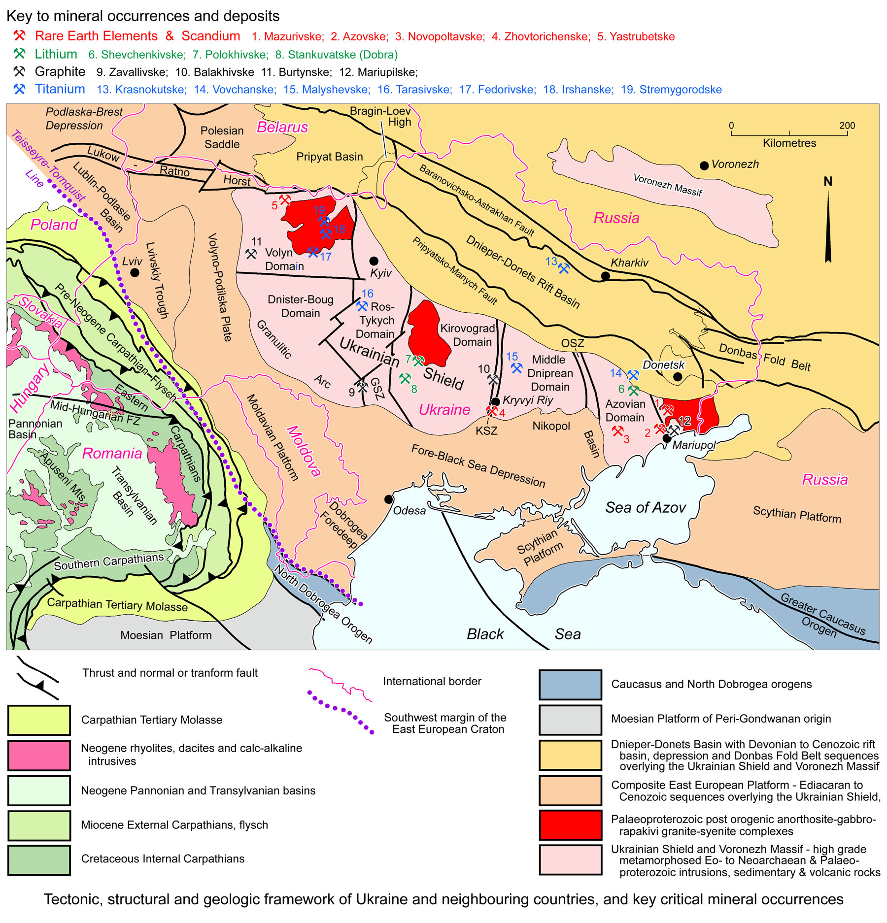
Each of the six domains is separated from its neighbour by a major fault/shear/suture zone. The domains are referred to by different names in different papers, and alternatives are listed below. They are mostly of similar age, and are, from east to west the:
• Azov (Azovian or Pryazovskiy) Domain - composed of granitoids and greenstont belts containing granulite to epidote-amphibolite facies gneisses, schists and amphibolites. The domain predominantly contains 3.0 to 2.6 Ga Meso- to Neoarchaean domal gneissic trondhjemite-tonalite-granodiorite (TTG) massifs, with associated tonalitic gneisses and migmatites. These are surrounded by synforms and monoclines of strongly deformed, high-grade metamorphic supracrustal rocks after sedimentary complexes deposited in a shallow intracratonic basin. These sedimentary sections, which include siliceous iron formations, contain meta-sedimentary zircons with Hf isotope signatures at 3.75 Ga. Palaeoproterozoic tectono-magmatic activity involved regional metamorphism and deep folding with extensive potassium-type granitisation, described by Bobrov et al. (2008) as retrograde charnockite-granulite. This phase was followed in the east by late 1.7 Ga polyphase plutons of syenites, granosyenites and gabbros in the Eastern Pryazovia, as detailed below.
The northwestern third of the Azovian Domain is occupied by the Vovchansky Tectonic Block, characterised by the occurrence of rare metal and rare earth metal mineralisation. It contains fold dome complexes, made up of antiformal structures at two stratigraphic levels. The lower of these is composed of Palaeoarchaean metamorphic rocks, mainly plagio-migmatites and plagio-granite gneiss that underwent remobilisation during the late Mesoarchaean. Smaller domed antiformal bodies of amphibolite and gneiss are also evident. The upper level unconformably overlies the lower suite, with which it is co-folded, and is composed of amphibolite to granulite facies metamorphosed Palaeoproterozoic volcanic and sedimentary rocks. These include 90 to 320 m of metamorphosed pebble quartzites, 150 to 210 m of ferruginous quartzite and 150 to 500 m of gneiss. It has also been intruded by Palaeoproterozoic two-feldspar granite complexes and other granitoids (after Poliakovska et al., 2023; Claesson et al., 2014).
The eastern third of the Azov Domain is separated from the main mega-block by a major NNW-SSE shear to form what some authors (e.g., Isakov and Isakova, 2019) regard to be a separate domain, the Eastern Pryazovia. It is characterised by a composite intrusive complex that includes 2.1 to 2.0 Ga granites, sub-alkaline granites and granosyenites; ~1.8 Ga sub-alkaline gabbro, syenite, granosyenite and alkaline granites, with lesser ~1.8 Ga nepheline syenites, carbonatites and melteigites (Lobach-Zhuchenko et al. 2014). This intrusive complex is largely confined to the Eastern Pryazovia, although some younger 1.8 Ga fractions transgress the bounding shear zone into the periphery of the Azov Domain. However, whilst Poliakovska et al., 2023 note that the Vovchansky Tectonic Block is the main host to occurrences of rare metal and rare earth metal mineralisation, there also appears to be a close spatial relationship between REE, Lithium and hardrock Ti occurrences and the late to post orogenic ~1.8 Ga anorthosite-gabbro-rapakivi granite intrusions described above in the Eastern Pryazovia and similar complexes in the Kirovograd and Volyn domains.
The western margin of the Azovian Domain is occupied by the Orekhiv-Pavlograd Suture Zone (OSZ on the accompanying image), a steep, intracratonic, transpressional, ductile shear zone. It varies from 10 to >25 km in width, bifurcating and expanding to the south, and represents the reworked western margin of the Archaean Azov Domain and separates the latter from the Middle Dnieprean Domain. Reworked lithologies include 3.65 to 3.60 Ga tonalites. 2.88 Ga amphibolites after mantle plume-related basalts, and metasedimentary rocks derived from Archaean continental sources. Metamorphic events were recognised at 3.5, 3.4, 3.3, 2.85 and ~2.08 to 2.01 Ga, the most intense of which was the latter. An older 3.66 Ga tonalite has been found in the central part of the zone (Lobach-Zhuchenko et al., 2014).
• Middle Dniprean (or Srednepridneprovskiy) Domain, which is predominantly a granite-greenstone terrane, or as described by Isakov and Isakova (2019), an amphibolite-granite-plutonic-metamorphic complex. This domain is characterised by four main litho-tectonic complexes (after Zakharov, Martynyuk and Tokar, 2009):
i). charnockite-granulite metamorphosed complexes, representing an overprint on the oldest basement Archaean rocks of the domain. These are similar to charnokites in all of the other domains of the shield, but are best developed in this, the Dnister-Boug and Azovian domains;
ii). Plagiogranitoid-amphibolite, which is also well developed in the Ros-Tykych Domain further to the west;
iii). Tonalite-greenstone Complex, which represent the granite-greenstone belts of the terrane, that are, in turn, surrounded by the more extensive Plagiogranitoid-amphibolite facies. The tonalite-greenstone complex is composed of a lower, essentially volcanogenic complex, that is capped by the predominantly clastic facies of the overlying meta-sedimentary rocks [see point iv). below]. The volcanogenic section commonly includes distinct plutonic associations of similar age and composition. These rocks have undergone zoned metamorphism, ranging from greenschist to epidote-amphibolite, and rarely amphibolite facies. In one of the greenstone belts studied, Bobrov et al. (2008) describe a stratified pile of six constituent litho-facies: a). dacite-andesite-tholeiite volcanic suite, with associated early plutonic gabbro-diabase-diorite. b). komatiite-tholeiite, that is 5 to >6 km in thickness, principally composed of tholeiitic and komatiitic basalts, pyroxenite and peridotite komatiites, representing a range from essentially mafic → ultramafic → andesite-basalt lava-pyroclastic → essentially ultramafic compositions. c). Jaspilite-tholeiite - in most greenstone belts, the komatiite-tholeiite associations described immediately above, grade laterally into jaspilite-tholeiite suites which, in addition to the mafic and ultramafic extrusives, also include diverse tuffaceous-sandstones and siltstones, argillites and quartzites, including magnetite-rich varieties, which overlie and laterally merge into the komatiite-tholeiite associations. d). Upper komatiite-pyroxenite, which comprises a volcanogenic upper komatiite with associated plutonic gabbro-pyroxenite intrusives. This is in two parts, a lower, essentially volcanogenic, pyroxenite komatiite and stratified basalt flows, and the upper, essentially chemogenic-sedimentary part. e). Rhyolite-dacite - volcanogenic rhyodacite and comagmatic sub-volcanic to plutonic tonalite-plagiogranite associations. Rhyodacite-plagiogranite from this grouping has been dated at is 3.2 to 3.0 Ga (Artemenko, 1998).
iv). Granitoid and Meta-sedimentary rocks - which are zoned, ranging from granulite to greenschist facies metamorphism, with primary sedimentary stratification and associated two-feldspar granitoids.
The western margin of the Middle Dniprean Domain is occupied by the Krivyy Rih, or Inguletsko-Kryvorizka Suture Zone (KSZ on the accompanying image), bounded by the Inguletskiy and Kryvorizko-Kremenchutskiy deep-seated faults to the east and west respectively. The sequence structurally interleaved within this fault complex, is mainly meta-sedimentary rock suites separated by blocks of Archaean plagiogranitoids. These meta-sediments, which have been folded into a series of tight synforms, include sillimanite quartzites, amphibolites, garnet-biotite gneiss, amphibole-magnetite quartzite, amphibole gneiss, magnetite quartzites (banded iron formations) and pyroxene-magnetite quartzites. These rocks within the KSZ are from both the Middle Dniepr and the Kirovograd Domain.
The major Kryvyi Rih iron deposits are located within the western margin of the Middle Dniprean Domain, within the marginal fault zone of the Krivyy Rih, or Inguletsko-Kryvorizka Suture Zone, on the eastern flank of the Kryvorizko-Kremenchtska, Synclinorium Zone.
NOTE: Whilst major iron ore fields are predominantly exploited within the Krivyy Rih District,largely un-exploited iron formations are also found within the greenstone belts in the core of the Middle Dniprean Domain, within and adjacent to the Orekhiv-Pavlograd Suture Zone (OSZ) in both the Middle Dniprean and Azovian domains, elsewhere in the latter, as well as in the Ros Tykych and Dnister Borg Domains (see Mykhailov et al. 2022).
• Kirovograd (Kirovogradskiy or Ingul or Ingulets) Domain is dominated by late Neoarchaean and early Palaeoproterozoic metasedimentary rocks, which are interpreted to be deposited on an older Archaean basement. These include the 2.6 to 2.3 Ga banded iron formations (BIF) which extend into, and occupy large sections of the the Krivyy Rih Suture Zone (as described above) that separates the Kirovograd and Middle Dniprean domains. Supracrustal rocks of the Kirovograd Domain include flyschoid metasediments of the Ingulo-Inguletsk Formation, that have been metamorphosed to granulite facies in the west, and to amphibolite facies in the east. The Ingulo-Inguletsk Formation meta-sediments mainly comprise dominant two-pyroxene, pyroxene and biotite-pyroxene gneisses and mafic gneisses metamorphosed up to granulite and high-temperature lower amphibolite facies. These include interbeds of graphite-amphibole-biotite and magnetite-pyroxene gneisses in the lower sections, with biotite and garnet-biotite gneisses and mafic gneisses. They are overlain in synclinal cores by alternating biotite gneisses and meta-siltstones. Calc-alkaline meta-volcanic rocks are found in the eastern part of the domain, while carbonates and other sedimentary rocks predominate in the western parts. Proterozoic magmatic activity continued with the emplacement of the polyphase ~2.03 to 2.00 Ga Novo-Ukrainian monzonitic intrusions, followed by the ~2.0 Ga anatectic Kirovograd granites, migmatites and metasomatic alteration. Tectonic and magmatic activity ceased in this part of the Ukrainian Shield at ~1.9 Ga, with more stable cratonic sandstones and shales deposited on the newly developed crust to the west, remnants of which are locally preserved.
At 1757 to 1748 Ma, the large, 130 x 50 km, NNW-SSE elongated Korsun-Novomirgorod Suite, a composite pluton of gabbro-anorthosite-mangerite-charnockite and rapakivi granite was emplaced into the northwestern quarter of Kirovograd Domain (Claesson et al., 2006; Isakov and Isakova, 2019), although Lobach-Zhuchenko et al. (2016) refer to these as being of Mesoproterozoic age. Shumlyanskyy et al. (2017) have shown that basic and silicic rocks of the complex were emplaced between ~1757 and 1750 Ma; with the youngest stages being represented by monzonites and syenites that were formed between 1748 and 1744 Ma. Rare mineral pegmatites are associated with the granitoid phase of this suite.
This pluton is similar in size and composition to the Korostensky Pluton described below in the Volyn Domain and may be an equivalent of the similar intrusion described above in the Eastern Pryazovia section of the Azov Domain above. These plutons are interpreted to mark the final stages of cratonisation within the shield (Isakov and Isakova, 2019).
• Golovaniv (or Golovanivsko) Suture Zone (GSZ) - which separates the Kirovograd and Dnister-Boug domains. Like the other 'suture zones' described above, it is differentiated by its complex tectonic fabrics, including strong 'north-south' shearing, in contrast to the adjacent domains on both sides. Although broad to the south, it thins and passes into a narrow zone of faulting to the north between the Kirovograd and Ros-Tykych domains. It represents the most intensely metamorphosed southeastern extremity of the Granulitic Arc charnockites, that occupies the south western margin of the Dnister-Boug (or Podolian) Domain, as described below. Only a few authors recognise it as a separate tectonic entity, although it shares differing lithologies found within both the Dnister-Boug (or Podolian) and Kirovograd domains.
• Dnister-Boug (Podolskiy or Podolian) Domain - characterised by strongly deformed rocks that are generally metamorphosed to granulite facies, which according to Bobrov et al. (2008), are high temperature-pressure charnockites. These are collectively known as the Bug Granulite-Gneiss Complex, or the Granulitic Arc (Lobach-Zhuchenko et al., 2016). The evolution of this complex, which occupies the entire Dnister-Boug Domain and Golovaniv Suture Zone, as well as the southern-most Ros-Tykych Domain, includes rocks and tectono-magmatic events of both Archaean and Palaeoproterozoic age. It is composed of the:
i). Palaeoarchaean Dniestr-Bug Series, comprising granulite-facies granitoids, mainly of tonalitic composition, metamorphosed to an enderbitic gneisses, typically intercalated with two-pyroxene and amphibole-pyroxene schists. It is intensely banded and ubiquitously tightly folded. In addition to the enderbitic and mafic lithologies, it also includes schists and calc-silicates interpreted to be of supracrustal origin, plus garnet-biotite bearing leucogneisses (Claesson et al., 2015). The enderbitic gneisses have yielded ages of up to 3.65 Ga (Claesson et al., 2006), whilst a 3.66 Ga mafic intrusion, contaminated with felsic rocks, contains 3.74 Ga zircon xenocrysts with inclusions of plagioclase, K feldspar and quartz (Claesson et al., 2016). At 3.59 to 3.55 Ga, high-temperature and high- to moderate-pressure granulite-facies metamorphism accompanied migmatisation and deformation, and the formation of mafic granulites.
ii). inferred Late Neoarchaean Bug Series, which begins with the lower Kosharo-Oleksandrivka Suite quartzites and high-Al gneisses and schists that are commonly graphitic. These are overlain by the Khashuvato-Zavallya Suite carbonates, chiefly marbles and calc-silicates, with associated graphite-biotite, garnet-biotite, biotite and pyroxene gneisses. The Bug Series meta-sediments, which also include some enderbitic gneisses, are interpreted to have been deposited in depressions developed within the older Archaean basement (Claesson et al., 2015). Meta-trachybasaltic dykes dated at 2.0 Ga cross-cut these younger orthogneisses, whilst a 2.0 Ga pegmatoid granite dyke cuts a related supracrustal suite (Stepanyuk et al., 2013).
• Ros-Tykych (or Bila Tserkovskiy) Domain - the rocks of this domain have been grouped into two main lithotectonic complexes, and a late tectono-magmatic phase. The first of the main two is a charnockite-granulite complex to the west and SW, that grades into the 'Granulitic Arc' of the Golovaniv Suture Zone and Dnister-Boug Domain. The second is a plagiogranite-amphibolite complex further to the east, juxtaposed across the narrow faulted northward continuation of the Golovaniv Suture Zone with the Kirovograd Domain.
The Charnockite-Granulite Complex, which also occur within the Dnister-Boug, Middle-Dniprean and Azovian domains, is predominantly composed of:
i). alternating biotite-garnet plagiogneiss and gneiss, sometimes with sillimanite, cordierite, graphite, and lesser biotite-hypersthene mafic gneiss;
ii). predominantly mafic hypersthene plagiogneiss, an up to 3000 m thick suite, with two-pyroxene mafic gneiss and lenses of marble and calc-silicates, possibly derived from a volcanic protolith;
iii). an up to ~4000 m thick leucogranulite association, mainly preserved as relicts surrounded by migmatitic granite-gneiss of plutono-metamorphic gneiss-alaskite association;
iv). ~350 to 400 m of biotite-garnet-graphite gneiss, calc-silicates and magnetite-hypersthene-garnet-quartz rocks with a khondalite association;
v). ~2500 m of garnet gneisses, hypersthene gneiss and plagiogneiss, two-pyroxene and hornblende-two-pyroxene mafic gneisses, as well as of garnet-hypersthene-magnetite-quartz rocks.
This Charnockite-Granulite Complex was progressively formed between 3.65 and 1.95 Ga. The oldest dated zircons were crystallised at 3.65 Ga, whilst ~3.12 Ga zircons were formed under granulite facies PT-conditions. Amphibolite facies 2.78 to 2.72 Ga metamorphic zircons were crystallised in biotite-garnet leucocratic gneisses and mafic and ultramafic granulites. Palaeoproterozoic charnockites and anti-perthite enderbites were formed during an ultra-metamorphic reworking. The youngest, 1.95 Ga zircons occur in amphibole-two-pyroxene garnet-bearing mafic granulites after metamorphosed mafic dykes.
The Plagiogranite-Amphibolite Complex, is only found in the Ros-Tykych and Middle-Dniprean domains. The amphibolite facies regional and extended ultra-metamorphism that generated this complex, dominated a sequence of stratified and plutono-metamorphic associations, as well as subordinate plutonic suites. These stratified associations comprise rhythms grading from a lower gneiss-mafic gneiss, to an upper mafic gneiss-amphibolite suite. Both exhibit a paragenetic progression of biotite → hornblende (with epidote and carbonate) → plagiogneiss → mafic gneisses → amphibolite, with a wide-range of mafic minerals. Both show an upward increase in silica-depletion and lime-enrichment, and a corresponding increase in the relative thickness of the upper band.
All of these are discordantly overlain by a Granite/Gneiss/Sedimentary Complex, which is zoned from west to east, from granulite to greenstone facies, and dominated by primary-sedimentary stratified associations, two-feldspar plutonic granitoids, and local plutono-metamorphic associations. It comprises two main assemblages: ~3.0 Ga ferruginous-siliceous and 2.4 Ga carbonaceous-gneissic lithofacies. This complex represents a sedimentary protolith suite that was progressively more intensely metamorphosed and intruded from east to west.
• Volynskiy (or Volyn) Domain - whilst Charnockite-Granulite and Plagiogranite-Amphibolite complexes similar to those in the Ros-Tykych Domain are found in this domain, according to Claesson et al. (2006), the Volyn Domain is dominated by supracrustal rocks with 2.43 Ga and 2.2 Ga detrital zircons within the meta-sediments. These data, together with lithostratigraphic correlations, indicate that the Volyn Domain is composed of a largely juvenile Palaeoproterozoic continental crust. Various granitoid types have been distinguished within the domain, mostly with ages ranging from 2.2 to 2.0 Ga. In the far northwest of the domain, the Osnitsk-Mikashevichi Igneous Belt comprises major, 2.0 Ga granodioritic-granitic batholiths with subordinate gabbros and diorites. This NNE-striking structure follows the northwestern margin of the Sarmatian block. The northeastern third of the domain is occupied by the 1.80 to 1.74 Ga (Bogdanova, S., et al., 2004; Isakov and Isakova, 2019) composite, 12 000 km2, Korostensky Pluton. This pluton which is dominated by rapakivi granites, with major phases of anorthosite, gabbro-anorthosite, melogabbro and gabbro-norite of the Volodarsk-Volynsky, Chopovytsky, Krovotynsky, Ushomirsky and Fedorivka massifs. Complex magmatogenic deposits of apatite and ilmenite are concentrated within the Volodarsk-Volynsky massif. The bulk of the mafic-ultramafic phases, which occupy ~18% of the pluton, were intruded over a shorter period from 1.767 to 1.758 Ga. These comprise early anorthosite and later gabbro, gabbro-norite. Detailed work indicates emplacement in a series of events, producing a complex internal pattern: i). early anorthosite between 1.80 and 1.784 Ga, occurring as xenoliths in younger pulses; ii). the main anorthosite suite, including the typical black, coarse-grained anorthosite, with zoned iridescent plagioclase, inverted pigeonite, augite and iron-rich olivine of the Volodarsk-Volinskyy Massif; from 1.760 to 1.758 Ga; iii). the early and the late (1.795 Ga) gabbroic (olivine-bearing gabbro-dioritic) suites; iv). late dolerite, trachy-basalt and trachy-andesite dyke suite that cuts the anorthosite massifs, rapakivi granites and surrounding country rocks (Duchesne et al., 2006).
Shumlyanskyy et al. (2021) indicate the granites in the northern part of the complex crystallised between 1800 and 1780 Ma, whereas rocks in the southern part intruded mainly between 1768 and 1755 Ma. U-Pb zircon ages for granites from the south-western part of the Korosten complex indicate that granites were emplaced between these two parts, at 1770 to 1765 Ma, a few million years prior to the intrusion of the gabbro-anorthosite massif between 1762 and 1758 Ma, while chamber pegmatites in these granites crystallised at 1760 ±3 Ma, coevally with the basic rocks. Shumlyanskyy, et al. (2021) surmise that ultimately, the formation of the chamber pegmatites was related to the reheating of the semi-crystallised granitic intrusion and to fluids migrating from the underlying gabbro–anorthosite massif.
The Korostensky Pluton may well be part of the same tectonomagmatic event that produced the Korsun-Novomirgorod Suite intrusive complex in the Kirovograd Domain and the intrusions of the Eastern Pryazovia section of the Azov Domain (as described in those domains above, similarly in spatial proximity to rare metal mineralisation).
The core of most of the domains of the shield is composed of granite-greenstone terranes, with elongate greenstones belts generally trending north-south and/or NW-SE, which were deformed in the interval from 2.6 to 2.5 Ga in the Neoarchaean. These granite-greenstone terranes may be mostly concealed basement below late Neoarchaean or Palaeoproterozoic cover sequences, as in the Volyn and Kirovograd domains, occupy much of the domain, as in the Ros-Tykych and Middle Dniprean mega blocks, or be strongly deformed and metamorphosed to amphibolite → granulite facies, as in the Dnister-Boug and Azov domains.
The Shield is overlain to the NE by cover rocks of the Dnieper-Donets Depression the core of which is occupied by a major rift basin. This depression and rift separates the crystalline shield from the equivalent rocks of the Voronezh Massif to the NE. Deposition commenced with a thin successions of Middle Devonian, ~383 Ma, pre-rift, shallow marine platformal clastic rocks. This succession has since been variably eroded from the NE margins of the shield. At ~370 Ma in the Upper Devonian, the depression evolved into a rift that was superseded through the Carboniferous and Permian by a sag basin, that was, in turn, truncated by a pre-Triassic unconformity. The rocks of the depression overlie the Archaean to Palaeoproterozoic crystalline basement of the Ukraine Shield and trends NW-SE from where it is known as the Pripyat Basin in Belarus, passing over the Bragin-Loev High on the border with Ukraine to become the Dnieper-Donets Depression. In SE Ukraine, the depression transitions to become the Donbas Fold Belt, to then align with the Karpinsky Swell in neighbouring Russia further to the SE. The Donbas Fold Belt in the SE is more heavily deformed, characterised by exposed folds which gradually plunge to the NW into the main Dnieper-Donets Depression basin where they lose their tectonic expression. This latter transition is also marked by thrusts and revere faults. Basin inversion occurred in the Donbas Fold Belt in two, or possibly three, pulses during the Permo-Triassic and Late Cretaceous to Early Cenozoic. The width and thickness of basin fill, the intensity of inversion-related deformation, the degree of metamorphism of its exposed sediments, as well as the degree of syn-rift volcanic activity, all increase from NW to SE. The shallower sequence of the Pripyat Basin is only ~ 2 to 6 km thick and is ~80% composed of Devonian, whilst Carboniferous to Permian rocks dominate exposure in the Donbass Fold Belt. Depth to basement over the Bragin-Loev High is 1 to 3 km, whilst in the main Dnieper-Donets Basin rift it increases to the SE from 4.5 to 6 km and 12 to possibly 25 km in the Donbas Fold Belt furthest to the SE. On either flank of the rift-sag basin/depression, thinner wings of equivalents to the sequence in the main basin overlie the crystalline basement. To the SE, the southwestern wing of the depression wraps around the eastern nose of the Ukrainian Shield to merge with the Scythian Platform section of the East European Platform.
In the Ukraine and Belarus, the pre-rift platformal sedimentary rocks extended to the SW onto the Ukraine Shield and NE over the Voronezh Anticline/High. The absence of marginal facies within this sequence, has been interpreted to indicate the platform originally extended far beyond the present limits of the basin. The sequence comprises sandy-clayey and coarser clastic sedimentary rocks, with lesser associated beds of dolomite and anhydrite.
Below and grading upward into these more extensive cover sequences, the core of the Dnieper-Donets Depression is occupied by then intracratonic Dnieper-Donets Rift, bounded by the NW-SE to WNW-ESE trending, deep crustal Pripyatsko-Manych and Baranovichsko-Astrakhan faults to the SW and NE respectively. The rift was filled with Late Devonian Frasnian and Famennian carbonate and evaporite rocks. Widespread salt-deposition is reflected by local diapirs in the Donbas Foldbelt. The salt formations were preceded by organic-rich anoxic shales and carbonates. The uppermost Devonian rocks formed large sub-aqueous clastic fans along the southern basin margin, containing shales interbedded in coarser clastics. A total 4 to 6 km thickness of syn-rift basin infill has been estimated. Two Late Devonian salt units of Frasnian and Famennian age are included within this sequence. The Frasnian salt is up to 1000 m in thickness. The salt units, in turn, incorporate significant, relatively shallow, Famennian age potash beds in the Pripyat Basin of Belarus. These extend south at depth in the main Dnieper-Donets Basin in Ukraine. In Belarus, they are the basis of major potash mining operations from 4 main horizons. Concurrently with these evaporites and carbonates, clastic rocks derived from the Ukrainian Shield were deposited along the southeastern margin of the basin, and active rift related volcanism occurred, particularly in the northwest, during the Upper Devonian. The latter produced lavas, tuffs and volcanogenic sandstones which are unevenly distributed throughout the rift sequence. Two eruptive cycles of varying importance are identified: i)> an older late Middle to Upper Devonian suite, that is more diverse in composition, and is well developed at a regional scale; and ii)> a younger, Lower Visean event of much shorter duration. The earlier is up to 600 m thick and composed of vesiculated basaltic lava-flows with, interstratified thin and lenticular flow-breccias. These are accompanied by dacitic dykes, and by trachytic plugs and sills that are metres to tens of metres in thickness, cross-cutting the basaltic flows and basement to the south, and as vertical dykes and sills, 50 to 200 cm in thickness in late Devonian carbonates (McCann et al., 2003).
The Dnieper-Donets Rift evolved into a sag basin at the Devonian-Carboniferous contact. The depository filled by the unconformably overlying Carboniferous to Lower Permian sequence deepened southeastward along strike of the depression, to accomodate ~8 km or more of sequence. This succession was primarily composed of fluvial and marine clastic rocks, with some Visean (mid-lower Carboniferous) and Bashkirian (lower Mid Carboniferous) carbonates on the basin margins. The Middle to Upper Carboniferous section is composed of rocks deposited in coastal settings and includes abundant coal beds. The Carboniferous sequence hosts ~130 sub-bituminous to anthracite rank coal seams, each of which is >0.45 m, and up to 2.5 m thick. During the Early Permian, redbeds, carbonates, and salt were deposited in the basin, followed by an Upper Permian salt bed. During the Artinskian (late Early Permian), a collision with micro-continents along the southern margin of the Easy European Craton resulted in compressive stress and termination of the post-rift sag stage of basin development. The deepest part of the Palaeozoic rift/sag basin was then structurally inverted, thrusted, and folded, producing the Donbas Fold Belt, as described above. The entire basin was subsequently uplifted and eroded (Law et al., 1998). Truncation of older rocks was greatest in the southeastern part of the basin.
Deposition was resumed during the Triassic, mainly of marine clastics, and continued into the Cenozoic in a shallow platform depression setting that extended far beyond the Dnieper-Donets basin boundaries. The sequence, which is <3 km thick, includes Late Permian sands, Triassic shale, mudstone and sandstone; Cretaceous carbonates and Cenozoic sands, shale and mudstone. Pre-Tertiary uplift and erosion took place in roughly the same areas affected by pre-Triassic erosion. Plastic flow of Devonian salt beds began in the Early Carboniferous, forming salt domes and plugs which continued to evolve into the Tertiary.
Information in this Dnieper-Donets Depression section is drawn from Clarke (1987), Dyman et al. (1999), Privalov et al. (2004), Douwe et al. (2015).
The Voronezh Massif is the crest of a major regional high, that lies to the NE of the Dnieper-Donets Depression, and is overlain by a thin veneer of Palaeozoic sedimentary rocks that are the wings of the latter depression. In the south, the Donbas Fold Belt borders the limb of the concealed Voronezh Anticline along large thrusts and reverse faults. The Voronezh Massif is composed of similar Archaean to Palaeoproterozoic rocks as the Ukrainian Shield and is punctuated by north-south shear/suture zones that can be extrapolated to the south to correlate with structures cutting the shield. The Archaean basement of the massif is composed of substantially migmatised Mesoarchaean TTG gneisses (Sm-Nd, 3.6 to 3.4 Ga; Shchipansky et al., 2007). In the Kursk block that constitutes the partially exposed central part of the massif, TTG gneisses host the Kursk‒Besedino granulite domain (Savko, 2000; Fonarev et al., 2006) composed of a diverse selection of rocks, including metapelites, extensive banded iron formations (BIFs), meta-gabbronorites, and metapyroxenites. The metasediments contain detrital zircons dated at (3277 ±33 Ma; Artemenko et al., 2006). The age estimate of 2819 ±6 Ma (TIMS) obtained for monazite in metapelites is interpreted to corresponds to granulite metamorphism (Savko et al., 2010). The BIFs are responsible for the major Kursk Magnetic Anomaly. The Kursk Group of the Kursk block that hosts these BIFs are interpreted to be correlates of the BIFs of the Kryvyi Rih (Krivoi Rog) Group of the Middle Dniprean Domain of the Ukrainian Shield to the south (Savko et al., 2017).
The East European Platform, which covers an area of ~6 million km2, is a large and flat area of the East European Craton covered by sedimentary rocks in Eastern Europe, extending from the Ural Mountains in the east to the Tornquist Zone in the west, and from the Peri-Caspian Basin in the south to the Barents Sea in the north. The Tornquist Zone, defined by the Teisseyre-Tornquist Line in central and eastern Europe is the crustal boundary between the Precambrian East European Craton to the NE and the Phanerozoic orogens of South-Western Europe. An extension of this larger East European Platform extends to the south, and lies to the SW of the Ukraine Shield, separating it from the Teisseyre-Tornquist Line. This section of the platform between the Belarusan border to the NNW, and the Black Sea, has been divided, from NNW to SSE into the interconnected Volyn-Podillya Plate, Moldavian Platform and Dobrogean Foredeep. As such it forms part of the East European Continental Margin. Deposition along what was to become the greater southwestern margin of the East European Craton from the Baltic to Black seas, commenced with relatively rapid tectonic subsidence in the late Ediacaran, the rate of which systematically decreased during the Cambrian and Ordovician, characteristic of evolution from a syn-rift basin to post-rift thermal sag. The rift phase was accompanied by Ediacaran volcanic rocks. This rifting is interpreted to have been related to the break-up of the Rodinia/Pannotia supercontinent along the Teisseyre-Tornquist Line and the opening of the Tornquist Ocean. To the south, in the interval between the Ukrainian Shield and Teisseyre-Tornquist Line, there is evidence of a gradual change of tectonic regime into a collisional setting from the Silurian to Early Devonian. This is interpreted to be related to the distal Caledonian oblique collision between Avalonia and Baltica (the latter in this sense being the northwestern half of the East European Craton). This is indicated by a systematic increase in subsidence and uplift rates from the Late Silurian Wenlockian to the Early Devonian Lochkovian, interpreted to be related to development of a flexural foredeep. During the Pragian to Emsian in the Early Devonian, the basin hosted deposition of the post-collisional Old Red sequence. This was followed by Early to Mid Devonian tectonic uplift and erosion, possibly reflecting a temporary change to a compressive tectonic regime. Then, from the Mid to Late Devonian, short phases of rapid subsidence in local depocentres, in the western part of the Volyn-Podillya Plate and in the southern Dobrogea Foredeep, may be an indication of a transtensional tectonic regime. The Dobrogea Foredeep is developed on the edge of the East European Craton, ahead of the Devono-Carboniferous (Variscan) North Dobrogean Orogen to the SW. Post Variscan (latest Devonian to early Carboniferous) uplift and erosion has removed much of the Middle to Upper Devonian and Carboniferous sequence, other than in the west and south of this part of the platform, where the late Neoproterozoic Ediacaran to Lower Dervonian sequence is best preserved. From NNW to SSE, the sequence in the Volyn-Podillya Plate, Moldavian Platform and Dobrogean Foredeep dips outward, from west to SW and south and is 10 km thick in the north to 7 km in the Dobrogean Foredeep. The succession includes underlying Cryogenian continental to marginal marine variegated clastic deposits, followed by Lower Ediacaran volcanogenic to terrigenous strata, Upper Ediacaran conglomerate, passing up section into fine-grained terrigenous deposits. The Ediacaran succession is unconformably succeeded by Cambrian terrigenous sandstone and mudstone, which is, in turn, overlain by terrigenous and carbonatic Ordovician deposits (Gareckij et al., 1987). Upper Ordovician (Ashgill) to lower Silurian (Llandovery) rocks are locally absent, with succeeding Lower Silurian (Wenlock) units resting on eroded Ordovician, Cambrian and Ediacaran strata. The Silurian sequence comprises clay-rich, carbonate and carbonate-sulphate rocks, including graptolitic black shales, marlstones, limestones and dolostones with anhydrite interbeds and includes numerous hiatuses (Radkovets, 2015). This sequence passed upwards into Lower Devonian Lochkovian marine mudstone, carbonate and marl, and Pragian to Emsian terrigenous reddish-brown sediments that are generally equivalents of the Early Devonian Old Red Sandstone. Palaeo-erosional remnants of Middle and Upper Devonian clayey-terrigenous and sulphate-carbonate units followed, but are only preserved in the deepest parts of the Volyn-Podillya Plate and Dobrogean Foredeep. These were followed by Carboniferous (Bashkirian) coal-bearing terrigenous-carbonate sequence, although they are only preserved locally on the Volyn-Podillya Plate and in the Dobrogean Foredeep, where they unconformably overlie Devonian sequences following early Carboniferous tectonic activity and uplift. Permian to lower Triassic rocks are restricted to the Dobrogean Foredeep where thick developments unconformably cover Carboniferous and locally the Upper Devonian sequences. The Lvivskiy Trough to the NW is the deeper outer section of the Volyn-Podillya Plate where late Devonian and Carboniferous sequences predominate and are up to 9 to 10 km thick. Much of the information in this East European Platform description has been drawn from Poprawa, Radkovets and Rauball (2018)
To the north, the Lvivskiy Trough sequence passes into what is variously known as the Lublin-Podlasie Basin or the Podlaska-Brest Depression, which is the next subdivision of the East European Platform. The sequence on the northern margin of the Volyn-Podillya Plate and the Lublin-Podlasie Basin locally thins over an east-west basement high, the Lukow-Ratno Horst, that follows the Ukraine-Belarus border. This structure continues east to form the southern margin of the Pripyat Basin which is juxtapose with the Ukrainian Shield. To its immediate north, this horst marks the southern boundary of the Polesian Saddle, most likely the buried, fault offset extension of the Ukrainian Shield. The saddle is a basement high, over which the platformal sediments thin, acting as the western margin of the Pripyat Basin, and the eastern tapered edge of the Podlaska-Brest Depression. These horsts, saddles and depressions define the basement topography below the East European Platform sequence, but influence the margins of the elements of the Dnieper-Donets Depression succession.
To the south, the southern Moldavian Platform and Dobrogea Foredeep Ediacaran to Silurian sequences, as described above, continue east below a thick succession of Cretaceous to Paleogene sands, clays and chalk that belong to the Fore-Black Sea (or Dnisterska) Depression. This depression is developed over a north-south width of >150 km, from the Ukrainian Shield to the Black Sea coast, and forms the exposed, gently sloping, northern limb that extends south, under the sea, to a steeply north-dipping limb on the southern coast, in advance of the compressional western Pontides Orogenic Belt. At its thickest, this depression includes as much as 14 to 18 km of Cretaceous to Cenozoic sedimentary rocks. The east-west Pontides Orogenic Belt in northern Türkiye, passes westward to become the NW-SE trending Rhodopes in the Balkans, which are, in turn, the continuation of the Cretaceous to Cenozoic Alpine Orogen in southeastern Europe.
The uppermost, northeast margin/facies of the sequence within the Fore-Black Sea Depression, where it laps onto the Ukrainian Shield, is known as the Nikopol Basin. The profile of this basin commences with old crystalline basement, capped by a palaeoregolith, unconformably overlain by Cretaceous to Cenozoic sedimentary cover rocks, which on the northern margin, are predominantly of Oligocene age. These cover rocks are composed of gently (generally <5°) SSW dipping, coastal-marine platformal sedimentary rocks. The Nikopol Basin hosts an extensive manganese bearing horizon that extends as a single unit, varying from a few cm to 4.5 m in thickness, over an east-west interval of up to 250 km, parallel to the shoreline, and north-south width of up to 20 km. The host sequence commences with shallow sands containing coal lenses, passing up into sands, silts and clays, overlain by the manganese bed. The manganese bed is immediately underlain by a glauconitic unit. The main overlying succession passes laterally, from the palaeo-shoreline in the north, to deeper water in the south, over which interval it progresses from shallow water coastal continental facies sands, grading southwards into silts-sands-clays, to clays and marls, coquina limestone, and further to the south, to deep-sea water facies.
To the east of the Fore-Black Sea Depression, the East European Platform re-emerges as the Scythian Platform on the southeastern margin/extremity of the Ukranian Shield, separating it from the Greater Caucasus Orogenic Zone to the south. The sequence on the platform is underlain by Archaean to Palaeoproterozoic basement of the Ukrainian Shield, unconformably followed by Neoproterozoic to Lower Palaeozoic volcano-clastic rocks that form the lowermost sections of the platform sequence. These are overlain by up to 1750 m of fine-grained terrigenous clastic rocks and a major unit of predominantly shallow marine limestone. These have undergone greenschist facies metamorphism, and are intruded by middle to late Palaeozoic granitoids. Both the metamorphism and intrusion are the product of Devono-Carboniferous Variscan orogenesis. Carboniferous to Triassic molasse unconformably overlies the older Palaeozoic rocks and is, in turn, unconformably overlain by Lower Jurassic clastics with calc-alkaline volcanics. These volcanic rocks grade upwards into Jurassic to Cretaceous platform carbonates and then to early Palaeogene clastics (Adamia et al., 1984). The post Carboniferous sequence is up to 6000 m in thickness. It's facies directly reflect the varying tectonic activity within the Greater Caucasus Orogenic Zone to the south. This includes a suite of syn-orogenic basins lapping onto the northern slopes of the Greater Caucasus Ranges carrying detritus shed from the range during the different phases of extension and uplift.
The Caucasus Orogenic Zone, and juxtaposed and overprinting Alpine-Tethyan terranes are reflected by a series of major, generally WNW-ESE trending mountain ranges between, and to the immediate south of the Caspian and Black seas. The Caucasus Mountains include some of the tallest peaks in Europe. NOTE: The bulk of this orogenic zone is to the south of the accompanying regional image, with only the northwestern periphery of the Greater Caucasus being included.
Activity within this Palaeozoic to Cenozoic composite orogenic zone may be summarised as follows, based on a detailed study by Vasey et al. (2020):
• Rocks of the Caucasus basement initially formed in the Early Palaeozoic as a magmatic arc deposited on older gneissic rocks on the active northern margin of Gondwana. It was separated from the passive margin of the East European Craton by an intervening ocean.
• At ~480 Ma in the Lower Ordovician, a ribbon-like sliver that was to become the basement to the Greater and Lesser Caucasus, was rifted from Gondwana and began to drift towards the East European Craton passive margin, advancing over a south to SSW dipping subduction zone. This drift persisted through the Silurian and Devonian into the Carboniferous, producing further magmatic arc rocks on the Caucasus basement.
• At ~330 to 300 Ma in the Carboniferous, the Caucasus sliver collided with, and was accreted to, the southern East European Craton margin. This was marked by a high P/T suture. Subduction then jumped to the south, to be initiated on the ocean margin of the Caucasus 'sliver', dipping north below both that Caucasus basement sliver and contiguous East European Craton to the north, and developing a new magmatic arc on the active outer margin of the Caucasus sliver.
• During the Lower Jurassic to Early Cretaceous, from 190 to 135 Ma, this latter subduction continued, with multiple pulses of alternating back-arc basin rifting followed by basin inversion. This zone of repeated back arc basin extension and inversion separated what were to become the Greater and Lesser Caucasus' to the north and south respectively, and culminated in the formation of the intervening 'Caucasus Basin', also known as the Rioni and Kura basins. The final closure of this latter basin was along the major south vergent Main Caucasus Thrust. The multiphase back-arc basin development is taken to be the product of changes in Mesozoic subduction dynamics within the wider Tethyan system.
• During this latter interval, across the ocean to the south, further broad slivers were rifted from the Gondwana margin, principally what was to become the amalgamated Anatolian‐Tauride‐Armenian-Block to the west and the Bitlis‐Pötürge or Central Iran Block to the SE. These migrated to the north to collide with the Lesser Caucasus during an Eocene‐Miocene accretionary event.
• Finally, from ~10 to 5 Ma, the advancing Arabian Platform, overlying the main Africa/Arabia Plate collided with the accretionary collage to the north. This represented the main Tethyan/Alpine collisional event in this part of Eurasia, but also resulted in reactivation of major structures as far north as the Great Caucasus.
In summary, this sequence of events has produced the following progression, from north to south:
• The Scythian Platform, predominantly deposited on the margin of Laurasian Ukrainian Shield basement, but also partially overlying Gondwanan Caucasus sliver continental basement. The southern margin of the platform is obscured by voluminous foreland basin accumulations derived from the mountains of the Greater Caucasus;
• Greater Caucasus Orogen composed of a core of exposed exotic Gondwanan Neoproterozoic to Mid-Palaeozoic crust basement and a Variscan/Hercinian Mid-Palaeozoic magmatic arc. These are overlain by Triassic and Jurassic volcanic and sedimentary rocks, all of which have been deformed by ongoing SW-vergent compressional and extensional tectonic activity to form the Cretaceous to Holocene Greater Caucasus Fold and Thrust Belt.
• Caucasus Basin, mainly the Rioni and Kura intermontane depressions, interpreted as foreland basins formed in Oligocene to Early Miocene times, separating the Greater and Lesser Caucasus. These are filled with Miocene molassic and volcanic rocks and overlain by Pliocene and younger volcanic and sedimentary rocks;
• Lesser Caucasus Orogen, which is variously interpreted to be continuous with the Pontides to the west and the Alborz Zone in Iran to the SE. This also has a less well exposed core of Gondwanan Neoproterozoic to Mid-Palaeozoic basement that was tectonised during the Late Palaeozoic Variscan equivalent event. This core is overlain by a Tethyan Jurassic to Cretaceous magmatic arc, dacitic to andesitic basalt volcanic plateaux and a belt of ophiolites, overlain, in turn, by Cretaceous to Eocene sedimentary rocks and more andesitic basalts.;
• Alpine-Tethyan Taurides, Anatolides and Central Iran Domain. The Taurides, and Anatolides to the west, each comprise an east-west elongated carbonate platform that was developed on a basement continental fragment that was rifted from Gondwana during the Triassic, migrated north and collided with the Lesser Caucasus. These were re-amalgamed with Gondwana by subduction of the intervening ocean with continent-continental collision during the Oligocene to Miocene (Karaoglan et al., 2016) or Miocene (Okay et al., 2010). Ophiolites are developed on the northern and southern flanks of these platforms, generated above intra-oceanic subduction zones and emplaced over the Tauride carbonate platform from different Neotethyan oceanic basins in the Late Cretaceous. These ophiolites were emplaced as nappes during collision and later by obduction prior to collision (e.g., Parlak, 2016).
The North Dobrogea Orogen is located on the western margin of the Black Sea, and most likely represents the western extremity of the Caucasus Orogen. It passes below the Black Sea to the SE; is in fault contact with the Dobrogea Foredeep to the NE; is overthrust by the Carpathian Orogen to the west; is overlain by Tertiary molasse shed from the latter; and abuts the Moesian Platform to the SW. It is bounded by two crustal scale faults, the Sfântu Gheorghe and the Peceneaga-Camena faults to the north and south respectively. It is divided into two distinct parts, separated by an oblique longitudinal line, each representing a different lithological and structural settings to the base of the Triassic. The Macin Zone, that occupies the full preserved width of the orogen in the NW, tapering to the southern margin in the SE. It has a Neoproterozoic to Lower Ordovician basement of amphibolite to greenschist facies metamorphic rocks. These are overlain by a Silurian to Lower Devonian sequence, marking an upward shallowing trend, from deeper to shallow marine, neritic, to reefal in the middle Devonian and finally, after a hiatus to continental in the Carboniferous to Permian. Alkaline felsic volcanics, associated intrusives, and epiclastics dominate the Permian. Both the Palaeozoic succession and the metamorphic basement rocks are intruded by Carboniferous calc-alkaline and Permian alkaline magmatic suites. The Tulcea Zone, which is narrowest in the NW on the northern margin of the orogen, expands to the SE. It was deposited on a basement of oceanic crust and is composed of Upper Ordovician to Lower Carboniferous deep marine facies that may have been deposited in a trench. During the Triassic, massive and pillow basalts, basaltic volcaniclastics, and rhyolithic volcaniclastics and lava flows were emplaced across the orogen, but mostly preserved over the Tulcea Zone. These were followed by Triassic basinal shallow marine sequences, Jurassic turbidites, and post-tectonic Jurassic to Cretaceous limestones to sandy limestone.
The information in this paragraph we principally from Melinte-Dobrinescu et al (2020); Gradinaru and Gaetani (2019); and Savu, (2012).
The Peri-Gondwanan Moesian Platform is juxtaposed across the Peceneaga-Camena Fault with the southwestern margin of the North Dobrogea Orogen. It is bounded to the north by the Carpathian Orogen across a dextral transform, which includes a south vergent thrust component, and is overlain by Tertiary molasse shed from that orogen. The Moesian Platform underwent significant Variscan deformation, and during the Late Carboniferous, was accreted to the Scythian/East European Platform and basement, across the North Dobrogea Orogen (Seghedi 2001). However, an Early Triassic rifting event has been interpreted to have separated the Moesian Block from the Scythian/East European Platform and crystalline basement along the Teisseyre-Tornquist Line, only to be re-accreted to it during the Jurassic Cimmerian phase of the North Dobrogean Orogeny (e.g. Seghedi 2001). The final welding took place along the Peceneaga-Camena Fault Zone before the end of the Early Cretaceous. In the NE, proximal to the North Dobrogean Orogen, Moesian basement includes up to more than 2500 m of Ediacaran turbidites and structurally separated plagiogneisses and amphibolites that underwent late Ediacaran amphibolite facies metamorphism at ~570 Ma. Platform cover is composed of Upper Jurassic reef limestones and calcarenites. Further to the SW, older basement is evident, including orthogneisses that have undergone predominantly medium grade Palaeoproterozoic (Orosirian) metamorphism at 2002 ±22 Ma (Săbău and Negulescu, 2016), overprinted by Late Neoproterozoic remobilisation. The platform cover is largely composed of latest Jurassic and Cretaceous calcarenites, reef limestones to marls and glauconitic sandstones, overlain by Paleogene to Pleistocene limestone, calcareous limestone, lacustrine limestone, pebble beds, red silty clays and Holocene loess.
The information in this paragraph we principally from Melinte-Dobrinescu et al (2020); and Savu, (2012).
The Carpathian Orogen, which is to the north of the Moesian Platform and to the west of the East European Platform, has been thrust over both platformal sequences onto the southwestern margin of the East European Craton. The Carpathian Orogen belongs to the Tethysides, which extend from the Atlas Mountains of Morrocco to Southeast Asia, and are the result of the closure of the Tethys Ocean during Cretaceous and Miocene convergence events. In Western Ukraine, as well as neighbouring Poland, Slovakia and Romania, the Carpathian-Alpine Orogen forms a loop shaped double structural arc, as three sides of an annulus open to the SW, surrounding the Neogene Pannonian basins and its subdivisions. The generally NW-SE aligned Eastern Carpathians occupy the eastern segment of this curvilinear arm, curving to form the east-west Southern Carpathians in the south and the near east-west Central Carpathians to the north. The latter becomes the Eastern Alps further to the west (and west of the accompanying image). Two main periods of compression have been recognised in the Eastern Carpathians, together producing a complex pile of NE vergent, imbricated nappes, during:
i). the Cretaceous, forming the Eastern, Southern and Central Carpathians, made up of 'sheared nappes' of the Internal Carpathians. These are composed of crystalline basement rocks, including Late Neoproterozoic, Ordovician and Devonian schists and gneisses with variable metamorphosed acid and/or intermediate granitoids and rhyolites, overlain by un-metamorphosed late Carboniferous to late Cretaceous marine sedimentary cover rocks that were deposited on a continental margin. Individual nappes range from all basement, to all cover with others that include both. These nappes include sequences known as the Inner, Middle and Outer Dacides in the Eastern Carpathians, but also include the Late Cretaceous Marginal Dacides of the Southern Carpathians. Two ophiolite nappes, known as the 'Transylvanides', are found separating the Middle and Inner Dacides in the Apuseni Mountains (in the SW) and Eastern Carpathians further north. These may represent oceanic crust of the Ceahlau-Severin Ocean, the product of Mid to Late Jurassic rifting that separated two or more Peri-Gondwana domains that were subsequently dislocated to form the various nappes of the Carpathians. The lowermost nappe of the Internal Carpathians is occupied by oceanic facies sedimentary rocks of the Outer Dacides, interpreted to have been deposited on basaltic crust in the Ceahlau-Severin Ocean.
ii). a younger Miocene event that formed the External Carpathians. These are composed of 'cover type nappes' that are well developed, and form the Flysch Zone of the East Carpathians, and are also known as the Moldavides. They are made up of Cretaceous marine basinal sedimentary rocks and of Paleogene to Neogene flysch, and the inner nappe of the outer Neogene molasse deposits. At different levels they include, shaly, pelagic or bituminous (black-shale) units. The outer nappes also contain Neogene evaporitic formations with salt and/or gypsum. The siliciclastic facies were derived from two principal sources, the Moesian Platform basement and from the Dacides of the Internal Carpathians. During this event, the older Internal Carpathians were thrust over the External Carpathians.
The Carpathian 'loop-shaped' structure is the result of subduction of the oceanic slab of the passive East European Craton margin beneath the Peri-Gondwana composite Tisza-Dacia and Moesia Domain that was approaching from the SW. This subduction zone had a NW-SE strike, and dipped to the SW. Its NW and SE extremities were governed by sinistral and dextral transform faults respectively within and parallel to the Central and Southern Carpathians. Meanwhile, another major NW-SE striking subduction zone was developed along the Adriatic coast of Croatia, Bosnia Herzegovina and Montenagro (west of the accompanying image), dipping in an opposite sense, to the NE, forming the Dinarides Arc inland of that coastline. This arc abutted the Eastern Alps to the north and the Southern Carpathians to the SE, closing the circle of the Carpathian 'loop'. The Dinarides are divided into Internal and External domains. The External Dinarides are primarily composed of Mesozoic platform carbonates and syn-tectonic sedimentary rocks deposited on a continental basement ribbon formed during the Triassic to Early Jurassic extensional involved in the breakup of Pangea. This was followed by a tectonic reversal, convergence, intra-oceanic subduction, obduction of the oceanic crust and then collision between that sliver and the craton. The resultant crustal thickening, and delamination and detachment of sub-crustal-lithospheric-mantle promoted uplift. The Internal Dinarides are a complex geological strip formed by a stack of nappes that developed during collision, characterized by ophiolites, oceanic sediments, and parts of the older continental Adria plate to the west (Balling et al., 2021).
The activity on these two opposing, parallel subduction zones, i.e., the Eastern Carpathians to the east and Dinarides to the west, produced a major shared back-arc basin, the Pannonian Basin, ringed by the Carpathian and Dinaride orogenic zones and the two transform faults below the Central and Southern Carpathians to the north and south respectively. This basin is floored by continental lithosphere with differing regional affinities, separated by the near WSW-ENE Mid-Hungarian Fault Zone. The southern of these basement basin floor blocks is the compositeTisza-Dacia Domain, juxtaposed across the fault zone to the north by the ALCAPA (Alpine-Carpathian-Pannonian) Block. The basin floor has undergone considerable extension, driven by the rapid rollback of the subducting Carpathian slab to the NE between 20 and 9 Ma and by the opposing slab below the Dinarides on the Adriatic coast to the SW, also during the Miocene. The main extensional event within the Pannonian Basin commenced at ~17 Ma (Ar-Ar and U-Pb; Pálfy et al., 2007), generally dominated by half grabens. Extension was accompanied by large-scale Neogene high-SiO2 rhyolites and rhyodacites, followed by calc-alkaline magmatism in the exterior of the Carpathians. These were succeeded by adakitic to alkaline suites that included basalt, andesite, dacite and rhyolite. Early Miocene deposition was dominantly characterised by fluvial, lacustrine, and other continental sediments. Subsequent Mid Miocene transgression was accompanied by deep basinal sedimentary rocks such as pelagic marls, clays and anoxic marls in the centre of extensional half grabens, while deposition along their margins is predominantly near-shore to shallow-marine facies, including shallow-water algal limestone. Peak tectonic activity along normal faults occurred during the Mid Miocene, which was followed by a postrift, thermal sag phase starting at around the mid to late Miocene boundary, at ~11.6 Ma. During the Late Miocene to Pliocene, this post-rift thermal subsidence caused the sedimentation of an unusually thick basin fill, locally exceeding 8 km (Tari et al., 2023). Deposition during this phase involved a reversal from deep pelagic, via pelagic and turbiditic to shelf margin and deltaic facies, with local alkalic sodic basalts and trachytes. A latest Miocene to Quaternary contractional inversion led to uplift and a sequence characterised by alluvial plain sedimentation. The rollback of both the Carpathian and Dinaride slabs is interpreted to have resulted in extension within the shared Pannonian back-arc basin, followed by slab break-off. It is regarded likely that under this extensional regime, the crust beneath the basin, which had been thickened by contraction during the previous subduction advance, underwent delamination and detachment. The resultant thinned crust, was then exploited by diapiric upwelling of athenosphere, making the Pannonian one of the hottest basins in Europe. This, or similar variations, are suggested by Harangi et al. (2024), Balázs et al. (2016), Matenci et al. (2012), Gemmer and Houseman (2006), Lenkey et al. (2002).
To the south of the transform fault below the Southern Carpathians, the Dinarides becomes the Hellenides, which are very similar in character. However, the Eastern Carpathians are terminated to the south by the same structure, with strain instead being absorbed by the Balkanides, which are similar, but related to east dipping subduction, parallel in both strike and dip to the Hellenides/Dinarides (i.e., opposite in dip to the Eastern Carpathians). As a consequence, the intervening back arc basin was much narrower, now occupied by the high grade metamorphics of the elongate Serbo-Macedonia Massif representing the uplifted and deeply eroded basement to the back-arc basin.
RARE EARTH ELEMENTS (REE)
The Ukrainian Shield is regarded as being prospective for rare earth element [REE] deposits and occurrences. The majority of the known occurrences are genetically linked to Palaeoproterozoic intrusive complexes, which formed between 2.1 and 1.7 Ga. These complexes comprise alkaline and sub-alkaline rocks, carbonatites, and granitic pegmatites. In some cases, although to a lesser extent, they are also associated with metasomatised rocks associated with the mineralised igneous intrusions (Poliakovska, et al., 2023).
Ukraine is considered one of the largest REE metallogenic provinces in Europe (Mykhailov 2010), with several hundred REE occurrences and districts having have been identified, almost exclusively within the Ukrainian Shield. However, few have been tested to the level of defining economic Mineral Resources, let alone Ore Reserves, and as a consequence, none have been mined for REE. Knowledge of the known occurrences is based on exploration and mapping undertaken during the Soviet era in the 1960s to 1980s. Of the 6 main mineralised accumulations, reserves have only been released for one, namely Novopoltavske (see below).
Known REE bearing mineral occurrences are associated with carbonatite (e.g., Novopoltavske in the Chernigovskii Complex) and mariupolites, a leucocratic variety of nepheline syenite characterised by the absence of K feldspar and the presence of albite and aegirine (e.g., Mazurivske), and other resources such as zirconium and REE-zirconium mineralisation associated nepheline-free syenites (e.g., Azovske, Anadolske, and Yastrubetske). The largest known potential resource is at Novopoltavske. A 13-year assessment was undertaken at Novopoltavske, but no attempts were made to develop the deposit, either before or since the breakup of the Soviet Union in 1991.
The principal known REE occurrences and resources are separately described below (mostly sourced from Mykhailov et al., 2022; 2023):
Novopoltavske or Novopoltavskii (#Location: 47° 15' 44"N, 36° 19' 7"E)
The Novopoltavske carbonatite REE-apatite occurrence is located in the Azov Domain, ~100 km WNW of the city of Mariupol and ~110 km SE of Zaporizhia. It lies within carbonatites of the 2.19 to 1.82 Ga (Kogarko et al., 1995) Chernigivskiy Complex, intruded into the Orikhovo-Pavlogradskiy Suture Zone, on the western edge of the Azov Domain of the Ukrainian Shield (Voinovsky et al., 2000; Glevaskiy and Kryvdik 1981). Mineralisation was discovered in the district in 1970 and preliminary exploration undetaken between 1975 and 1985, with a more detailed study of the Novopoltavske occurrence between 1982 and 1991.
Nepheline and alkaline syenites, and apatite carbonatites, form en-echelon, steeply dipping lenses that range from 10 to 20, up to 100 m in thickness and
extend over distances of hundreds of metres to kilometres. Individual lenses are composed of calcite and calcite-dolomite carbonatite, and occur as massive dykes and as stockworks. The carbonatites range from 50 to 90% calcite, up to 70% dolomite, with 3 to 40% biotite or phlogopite, 0 to 30% olivine, 3 to 30% apatite and 0 to 15% magnetite, with minor monazite, pyrochlore, cerite [Ce,La,Ca)9(Mg,Fe3+)(SiO4)6(SiO3OH)(OH)3], fergusonite [Y,REE)NbO4], columbite, getchellite, zircon, baddeleyite, orthite, aeschynite [(Ce,Ca,Fe,Th)(Ti,Nb)2(O,OH)6], and fersmite [(Ca,Ce,Na)(Nb,Ta,Ti)2(O,OH,F)6]. In particular, four main REE and zircon associations are recognised:
i). monazite-cerite-fergusonite in calcite and dolomite-calcite carbonatites;
ii). getchellite with baddeleyite in calcite carbonatites;
iii). pyrochlore-columbite with zircon in carbonatite phenites;
iv). pyrochlore-zircon in syenitic alkaline rocks.
The principal rare earth bearing mineral is monazite, in which the REE content is as high as 65%, although it has a low thorium content of ~0.1 to 0.3%, which would enhance the value of any concentrate marketed.
REEs are also concentrated in apatite. The average apatite content of the carbonatites is 10%, sometimes reaching 30 to 50% in small phoscorite bodies. The average REE content of apatite is usually 1.0 to 1.5%, to a maximum of 8 to 11%. Within the apatite, the light rare earth elements (LREE's) Ce (0.6 to 1.1%) and La (0.1 to 1.6%) predominate. Other REE's present within the apatite include 150 to 600 ppm Y; 250 to 400 ppm Sm; 40 to 150 ppm Eu; 40 to 100 ppm Tb; 10 to 20 ppm Yb; 0.3 to .07 ppm Lu. Of these, Sm and Eu are LREE's, whilst Y, Tb, Yb and Lu are the more valuable heavy rare earth elements (HREE's). Sr is also present in apatite, but usually <0.5 to 0.7%, although sometimes it may be as high as 1.5 to 2.5% or even 5%.
The overall grade of the deposit ranges from 0.17 to 4.6% REETotal; accompanied by 600 to 3000 ppm Nb2O5; 20 to 30 ppm Ta2O5; and 4.3% P2O5.
In weathered/oxide zones, that may extend to depths of from 50 to locally as much as 370 m, the content of the various elements of interest may increase by a factor of 'several times'. In particular, columbite and apatite are concentrated to the greater depth range above in areas such as adjacent to fault zones. However, within the oxide zone, all niobates, with the exception of columbite, are destroyed and transformed into earthy species.
In addition to carbonatite, the Chernigivskiy Complex also includes mineralised alkaline pyroxenites with ilmenite, as well as phenites. The
latter contain 0.15 to 0.37% Nb2O5, and up to 0.7 to 1.0% Zr within columbite, pyrochlore-getchellite and zircon (Zagnitko et al., 2017).
The Resource Potential of the carbonatites to a depth of 500 m, according to Mykhailov and Kryvdyk (2004), could be as much as 1 Mt of contained monazite concentrate, potentially yielding up to 500 000 tonnes of rare earth oxides. In addition it may contain ~200 Mt of apatite for 2 Mt of REO. Total hard rock resources for phosphorus, tantalum, niobium, fluorine ore are assessed to be 384.7 Mt (Mykhailov et al., 2007).
Although not exploited for REE, the complex has been mined, principally for phosphate at the Pivdenne and Pivniche mines in the form of apatite from the weathered profile, where it is preserved and the grade enhanced. At a 0.3% ZrO2 cut-off, one large and seven small zirconium resources have been identified at a grade of 0.52% ZrO2. A zirconium concentrate produced from this mineralisation has a grade of 64% ZrO2 with 1% HfO2 (State Geologic and
Subsoil Survey of Ukraine website, 2025). More recently, a reserve estimation has been released, including tonnages of apatite, strontium, rare earth elements and fluorine, plus unstated tonnages of recoverable tantalum and niobium, and the property offered for tender. Those reserves are as follows based on the Soviet Era reserve classification:
B+C1 Reserves - 859.628 Mt @ 4.92% apatite, 0.1% Sr, 0.22% F;
B+C1 Reserves - 85.962 Mt @ 2.25% Rare Earths;
B+C1 Reserves - 19.452.3 Mt of 66% magnetite concentrate;
C2 Reserves - 95.858 Mt @ 4.45% apatite, 0.09% Sr, 0.286% Rare Earths, 0.20%F.
C2 Reserves - 2.159 Mt of 66% magnetite concentrate;
NOTE: These reserves are quoted in the Ukraine source literature as tonnage of ore and tonnage of commodity, listed separately for each commodity. These have been converted above to ore tonnage and grade. Where the ore tonnage for more than one commodity are the same, it has been assumed they represents the same block of mineralisation and lumped together. Note also that the grade of B+C1 Reserves for REE is 2.25%, where as that of the C2 Reserves is 0.286%. However the B+C1 ore tonnage for all other components is 859.628 Mt, compared to the Rare Earth tonnage of 85.962 Mt. These exact same figure are currently found in both the Ukrainian Geological Survey, "Ukraine: Mining Investment Opportunities, Critical Raw Materials" document, and in the online data sheet for the Novopoltavske Field on the Ukraine State Geologic and Subsoil Survey of Ukraine website. These difference suggest the B+C1 REE ore tonnage may be in error with the decimal point in the wrong place, or that it represents a 10% concentrate.
As a general correlation, in the Soviet system A, B and C1 generally correspond to a Measured Mineral Resources in JORC and NI 43-101, and C2 to Indicated Mineral Resource.
A production license has previously been issued (at an unspecified date) for the extraction of these reserves, and plans were formulated for underground mining to a depth of 600 m, leaving a 100 m crown pillar to support the unstable rocks of the weathered zone. However, the production license has subsequently been withdrawn and no further work undertaken (Mykhailov, et al., 2023).
Mazurivske (#Location: 47° 30' 59"N, 37° 30' 1"E)
The Mazurivske zirconium-rare earth-niobium occurrence is located ~50 km north of the city of Mariupol in the Donetsk Region of eastern Ukraine, within the Vovchansky Tectonic Block of the Azov Domain. It lies within the Oktyabrskiy Intrusive Complex, which hosts pyrochlore-zirconium mineralisation in albitites and 'mariupolites'. Mariupolite is a leucocratic variety of nepheline syenite, characterised by the absence of K feldspar and the presence of albite and aegirine. The intrusive complex has an oval shape in plan and is 7 to 8 km in length and 5 to 6 km wide, elongated in a north-south direction. It is composed of subalkaline mafic and ultramafic rocks concentrically zoned from the periphery inward of pyroxenite → alkaline pyroxenite → gabbro → foyalites (K feldspar-nepheline syenites containing <10% ferromagnesian minerals) → pulaskites, all of which are cut by intrusions of mariupolite and nepheline syenite.
In the northeastern section of the complex, 4 x tabular bodies, principally composed of mariupolite, accompanied by nepheline syenite and microcline-nepheline syenite, occur within the larger gabbroid and pyroxenite mass of the intrusive complex (Zagnitko et al., 2017). They are shallow-dipping, from horizontal to 30 to 35°, with thicknesses of 1 to 79 m. The principal assemblage within these bodies includes nepheline, albite, aegirine, and sometimes microcline, accompanied by pyrochlore, zircon, and britolite [(Ce,Ca)5(SiO4)3OH], the latter of which is characterised by its high cerium content. Mineralisation coincides with zones of extensive albitisation within three of these mariupolite bodies, namely i). the 0.6 x 0.8 km Balka Mazurova Zone; ii). the 0.4 x 0.5 km Balka Koshkodieva Zone; and the iii). the 0.2 x 0.1 km Balka Dolynikova Zone. Mineralisation occurs as 0.1 to 1.8% zircon and 0.2 to 0.8% pyrochlore. The zircon crystals are mostly bipyramidal, and 1 to 7 mm across, although some isolated crystals may be up to 4 cm in size. These zircons are usually meta-mictic, opaque, brown to coffee coloured, with widely developed skeletal and zonal forms. The zircons carry 0.62 to 1.05% Hf, and 0.14 to 0.31% REE.
Pyrochlore [NaCaNbTa06F] holds the tantalum-niobium rare metal
content of the mineralisation. It occurs as stream-like clusters of dominantly honey-yellow, 0.02 to 0.08 mm octahedral crystals that may occasionally be up to 0.5 to 1.0 mm across. It contains 43.60 to 56.45% Nb2O5, 3.10 to 5.42% Ta2O5 and ~6% REE. The REE content in the mineralised zone averages 0.2%, 65% of which is in britolite and 1 to 5%, in pyrochlore.
These three shallow dipping tabular mineralised mariupolite/syenite bodies have been subjected to strong kaolin weathering near surface.
The Resource potential has been estimated at 0.2 Mt of REE2O3 (Mykhailov, et al., 2023).
Azovske (#Location: 47° 9' 42"N, 37° 16' 11"E)
The Azovske zirconium, REE mineralisation is located ~2.5 km SE of the township of Malynivka and ~25 km NW of the city of Mariupol, in the Donetsk region of eastern Ukraine.
The host Palaeoproterozoic Pivdennokalchykskiy Complex lies within the northeastern part of the Volodarskiy Massif of the Azovian Domain, in the eastern Ukrainian Shield. It is confined to a series of syenite bodies, the largest of which, the Azovskiy Stock, covers an area of 1.3 km2. This stock is composed of Palaeoproterozoic alkaline feldspar, pyroxene-amphibole and quartz syenites, as well as pegmatites (Metalidi, Nechaev 1983; Melnikov et al., 2000). Amphibole syenites and alkaline metasomatites are also extensively developed. Nine mineralised bodies have been found, each occurring as a crescent-shaped lode, generally up to several metres thick. The largest of these is 1640 m long and averages 32 m in thickness.
Where mineralised, these bodies are most commonly meso- and melanocratic syenites containing ferrohastingsite, hedenbergite and fayalite, and less often are leucocratic. Mineralisation is disseminated, and predominantly comprises
britolite [(Ce,Ca)5(SiO4)3OH],
with lesser bastnaesite [(La/Ce/Y)FCO3], orthite, zircon, monazite,
chevkinite [(Ce,La,Ca,Th)4(Fe2+,Mg)2(Ti,Fe3+)3Si4O22],
yttrialite [(Y,Th)2Si2O7],
magnetite,
rhabdofanite [Ce(PO4)•0.6H2O]
and fluorite. The average content of RE2O3 Total (total rare earth oxide) is 1.27%, with 1.5% ZrO2, 12 to 14 ppm U and 35 to 940 ppm Th (Melnikov et al., 2000). The relative abundance of the different rare earth elements as a percentage of the total REEs within a representative sample from Azovske is: LREE's Ce - 46.8%; La - 19.0%; Nd - 18.5%; Pr - 4.3%; Sm - 3.3%; and HREE's Dy - 1.7%; Er - 0.4%; Tb - 0.3%; Ho - 0.3%; Tm - 0.1%; Lu - 0.1%; and the Y - 0.5%.
Zircon occurs as dense 1 to 3 mm disseminated crystals, aggregates, and as grain intergrowths with feldspars, amphiboles and rare-earth minerals. The principal rare earth-bearing mineral, britolite, is found as irregular, up to 2 to 3 cm, inclusions, intergrowths and aggregates of prismatic crystals within pegmatoids. It occurs in a common paragenesis with zircon, orthite and rare chevkinite, and is a complex rare-earth mineral, usually dominated by cerium, but less commonly containing yttrium. Significant Y, may locally be up to 6 to 10% of total REE. Orthite is associated with both zircon and britolite, and in sections characterised by cataclastic hosts, occurs together with magnetite and fluorite, ifilling veinlets in the feldspar mass. Bastnaesite is also present, occurring as individual grains, bunch-like aggregates, inclusions in zircon, fluorite and vein minerals, and in pseudomorphs after britolite and orthite. The composition of the bastnaesite at Azovske averages: Y2O3 - 4.14%; RE2O3 Total - 56.36%; La - 12%; Ce - 21%; Sm - 105 ppm; Eu - 1070 ppm; Th - 2700 ppm; Yb - 42 ppm; Lu - 0.8 ppm.
A Resource Potential has been estimated to a depth of 300 m, and cut-off of 0.4% RE2O3 Total - 56 Mt @ 1.27% RE2O3 Total and 1.5% Zr2O3,
containing 0.71 Mt of contained RE2O3 Total, of which 20% are Yttrium, plus 0.84 Mt of Zr2O3.
Anadolske
The Anadolske mineralised system is located to the southeast of, and external to, the Oktyabrskiy Intrusive Complex, which hosts the Mazurivske occurrence, as described above, and lies within the Azovian Domain. The mineralised zone cross cuts part of the Anadolski Complex granites and metamorphic rocks of the Zakhidnopryazovska Series in the wall rock of the Oktyabrskiy Massif. The Anadolski Complex, which covers an area of 300 km2, has a leucocratic granite core and a periphery enriched with dark-coloured minerals that grade into migmatites. The Zakhidnopryazovska Series, which it intrudes, includes meta-sandstone and conglomerates; quartz-andesite-muscovite-sericite schists with rare staurolite and garnet; ferruginous quartzites with interbeds of magnetite-cummingtonite, magnetite-biotite-cummingtonite, carbonate, garnet-biotite-chlorite-quartzite; and quartz-garnet-biotite, garnet-amphibole-quartz-biotite schists and other similar lithologies.
Mineralisation occurs as a gently 30 to 45°SW dipping, ~1000 m long by 0.7 to 3.0 m thick zone, that can be traced to a depth of 400 m below surface. It is characterised by vein-stockwork fluorite-apatite-orthite mineralisation with a RE2O3 Total content of 0.1 to 16.7%, averaging 9.23%.
This mineralisation is massive, spotted, coarse and thinly banded, with a high content of Fe2O3, Fe and Ca, high Mn, P and F, low SiO2 and Al2O3. Rare earth minerals include orthite, cerite, bastnaesite, apatite and fluorite. Orthite forms bunches and lenses as much as 10 to 15 cm across as bundle- and fan-shaped aggregates of 0.5 to 1.5 mm elongated prismatic crystals. It contains 23.7% RE2O3 Total. Cerite forms inclusions of small 0.5 to 2.0 mm xenomorphic and isometric grains in orthite aggregates, with inclusion in fluorite, and contains 70.1% RE2O3 Total. Bastnaesite is confined to intergranular areas of orthite and replaces the latter. The RE2O3 Total content in bastnaesite is 60%. Apatite and fluorite carry 2.9 and 0.8 to 1.12% RE2O3 Total respectively and form thin layers in banded ores, which alternate with orthite layers, and chemically belong to the cerium varieties of apatite and fluorite.
Other Rare Earth Occurrences include:
Petrovo-Gnutivske - in the Kalmius River valley, northeast of Mariupol, in the Azovian Domain. REE mineralisation occurs as an up to 3 m thick, steeply-dipping fluorite-rare earth carbonate vein hosted by fenitised granosyenites in the endo-contact zone of the Kalmiuskiy Massif. This vein extends NE over a 1 km interval on a heading of 20°, and persists to a depth of >150 m. It comprises coarse grained and massive aggregates of calcite, bastnaesite, parisite and fluorite, hosted within a thick 'diallage' (a laminated mixture of augite and diopside) syenite, the footwall of which has been phenitised over a width of 25 to 30 m. The phenites are composed of albitised potassium feldspar rocks, with up to 11% orthite, cut by a stockwork of opal-like blue quartz veins. The hangingwall includes granosyenites that have been transformed into apatite-sphene-albite-arfvedsonite-aegirine phenites with zircon, chevkinite, ilmenite, magnetite and hematite. This hangingwall zone is up to 10 m thick, and is cut by veinlets of titanite that contain 0.37% Nb2O3 and 1.28% RE2O3 Total, fluorite and calcite.
In the hanging-wall contact of the mineralised vein, fluorite-carbonate-aegirine rims are observed. The mineralisation paragenesis is interpreted to compromise an early assemblage of fluocerite, bastnaesite, parisite and calcite, followed by a late association that includes fluorite, galena, argentite and other sulphides. Galena has been dated at 2.1 to 1.92 Ga. The rare-earth fluoro-carbonate content sometimes reaches 15 to 20%, with 62.6% RE2O3 Total in bastnaesite and
52.3% in parisite. Cerium is selectively crystallised. Parisite contains 94.7% La+Nd and 5.3% Sm+Lu; and in fluorite, Y + HREE's comprises 87.6 and 98.3% of the total REE content respectively.
No reserves or resources are available for this occurrence. It is included to illustrates a style of mineralisation.
Uspenivskiy (#Location: 47° 9' 42"N, 37° 16' 11"E) - The Uspenivskiy zirconium-thorium-rare earth mineralisation is located within the Azovian Domain. It is hosted by the albitised marginal sections of bodies of pegmatites and pegmatoid granites intruding a sequence of quartzites and gneisses of the Osypenkivska Series. The mineralised bodies vary from a few cm to 59 m in width, and persist over a length of up to 300 m, with grades of from 0.03 to 0.11% RE2O3 Total and 0.015% Y. Mineralisation occurs within a 78 to 92 m thick zone of oxidation and weathering and contains up to 5.45 kg/t of xenotime and 34 g/t monazite, and as a consequence is strongly radioactive. Uranium mineralisaton within the pegmatites has been dated at 2.0 to 1.9 Ga.
Yastrubetske (#Location: 47° 9' 42"N, 37° 16' 11"E) - The Yastrubetske zirconium deposit, located on the northern margin of the Ukraininian Shield, in the Volyn Domain, is very similar to the Azovske mineralisation (as described above), some 700 km to the SE. The mineralised zone contains the same britolite, orthite, bastnaesite assemblage as Azovske, although no bodies containing REE of significant grade have been encountered. The occurrence lies within the south-western section of the Perzhansky district, and is related to the alkaline syenite massif of the same name. It comprises several crescent-shaped mineralised zones, each up to 2 km long and 5 to 120 m thick, enriched with zircon, and is of interest, primarily as a zircon deposit. The zircon is accompanied by ilmenite, magnetite, apatite, orthite, bastnaezite, parisite, fluorite and britolite. The RE2O3 Total content of the individual bodies ranges from 0.07 to 0.3%, sometimes reaching 1.24% (Gurskiy 2008).
Of these REE bearing deposits, Azovske, Mazurivske and Yastrubetske are also considered to be significant hard rock zirconium resources in their own right. However, none of these three have been developed (Mykhailov et al. 2023) for either or both REE or Zr, as they are a less economically significant source of zirconium than the 8 x known significant placer Zr deposits in Ukraine. The latter are mostly the same major Ti (ilmenite) - Zr placer deposits described in the Titanium section of this record below.
Whilst the REE-bearing deposits and occurrences described above are predominantly within the Azovian Domain, other REE prospective districts and mineralisation styles are known as follows, although none appear to represent currently known significant deposits.
i). zirconium-thorium-rare earth mineralisation in granites, syenites and pegmatites, including the Mykolaivske and Sabarivske occurrences in the in Middle Dniprean Domain, and Yastrubetske (as described above) in the Polissya/Volyn Domain, and Uspenskiy (also as described above) occurrence in the Azovian Domain).
ii). uranium-thorium-yttrium-rare earth in potassium and sodium metasomatites (e.g., Lozuvatske and Kalynivske in the Central Ukraine uranium district of the Kirovgrad Domain.
SCANDIUM
Scandium, although not a lanthanide, is also regarded as part of the larger Rare Earth Metals grouping and has the properties of an HREE. Ukraine contains significant resources of scandium, specifically within the complex iron-uranium-vanadium-scandium Zhovtorichenske deposit, the apatite-ilmenite Stremygorodske (described below in the Titanium section) and Torchinske resources, the Zlobitske ilmenite placer accumulation, and in ilmenite and rutile placers. According to Mykhailov et al. (2022) scandium 'reserves' have been estimated for 13 complex deposits: Malyshevske, Valky-Gatskivske, Vovchanske, Zhovtorichenske, Stremygorodske, Fedorivske, Trostyanetske, Zlobytske, Torchynske, Irshanske, Lemnenske-Zakhidne and Lemnenske-Skhidne, but these remain confidential. Of these, 6 deposits are being developed.
Zhovtorichenske
The Zhovtorichenske complex iron-uranium-vanadium-scandium mineralisation, is located in the central part of the syncline of the same name, on the south-eastern flank of the ~100 km long Kryvorizko-Kremenchtska, Synclinorium Zone. The latter is a large, near north-south trending structure developed within both the Middle Dniprean Domain, immediately to the east of and overlapping much of the adjacent KSZ (Krivyy Rih, or Inguletsko-Kryvorizka Suture Zone) and hosts the bulk of the major Kryvyi Rih iron ore field. The Zhovtorichenske Syncline ranges from 0.5 to 2.0 km in width, with a submeridional length of >10 km in rocks of the Palaeoproterozoic Saksaganska and Gdantsivska Suites. The main pre-ore faults dip almost vertically, intersecting the stratification of the host rock at an angle of 5 to 25° and displacing them for up to hundreds of metres. Resultant zones of brecciation and fracturing are predominantly developed parallel to the host rock schistosity. Uranium and scandium-bearing zones associated with sodium metasomatites are located within both limbs and the southern hinge of the Zhovtorichenska syncline, and form sheeted, lenticular and pipe-like bodies.
The core of te Zhovtorichenske Syncline is occupied by the Gdantsivska Suite, which is divided into a lower unit of ferruginous quartzites and iron formations, one of the main Kryvyi Rih ore horizons, which unconformably overlies the Saksaganska Suite. The gradationally overlying sequence comprises up to 1 km of mainly marbles with minor interbeds of quartz meta-sandstones that have carbonate cement, and ferruginous quartzites that are 10 to 15 m thick. Graphite-bearing schists contain characteristic pyrite (rarely pyrrhotite) mineralisation.
The Saksaganska Suite underlies and flanks the Gdantsivska Suite core of the syncline, and is the main Kryvyi Rih ore horizon. It is composed of a 640 m type section of ferruginous quartzites and schists which occur in rhythmically alternating horizons. In the full stratigraphic column of the suite, there are seven schist and an equal number of ferruginous horizons connected one to another by gradual transitions. The lower two pairs of beds total 40 to 500 m in thickness, with quartz-sericite, quartz-actinolite, biotite-chlorite schist separating magnetite-martite jaspilites and magnetite-chlorite (amphibole) quartzites; the middle two units total ~260 m of sericite-biotite, chlorite-actinolite, quartz-graphite-sericite, rarely - hematite-chlorite schists, separating chlorite-magnetite and magnetite-amphibole-biotite quartzites; in the upper three pairs of beds, hematite-magnetite, magnetite-hematite-carbonate, amphibole-magnetite and hematite quartzites and jaspilites predominate, as well as hematite-chlorite, sericite-chlorite, chlorite-biotite and biotite-amphibole schists.
The Skelyuvatska Suite is developed throughout in the eastern limbs of all syncline structures of the Kryvorizko-Kremenchtska Synclinorium Zone, and underlies the Saksaganska Suite. Where present, it is seen to originally have been separated from the Saksaganska Suite by an eroded succession. It is composed of three sub-suites: a lower arkose-quartzite; Middle phyllite and Upper talc-carbonate.
The latter is partially flanked by the Konkska Series metabasalts, amphibolites, metasediments, quartzites with a total thickness up to
1200 m, which appears to lens out to the NE.
To the west and SW, the syncline is fringed by Palaeoproterozoic granites of the Kirovgradskiy Complex, whilst to the east it is flanked by granites of the Dniprovskiy Complex.
Mykhailov et al. (2022) describe one example of the occurrence of scandium mineralisation at Zhovtorichenske. Mineralisation occurs within quartz-sodium metasomatites, with uraninite, brannerite and vanadium-scandium ores occurring within partly dolomitised diopside-quartzites and actinolite schists developed within the Gdantsivska Suite (Zagnitko et al., 2017). The ore zone in this example is ~100 m long with a thickness that does not exceed a few tens of metres. Elsewhere, rare-metallic vanadium-scandium mineralisation occurs in zones (up to tens of metres thick and 1 km long) of carbonate-aegirine metasomatites, concentrated along the unconformable contact between the Skelyuvatska and Gdantsivska suites, and occurs as vein and lens clusters of alkaline-amphibole-acmite metasomatites with albite, apatite, malacon (a variety of zircon) and tremolite. Mineralised bodies are composed of uranium-rare earth and vanadium-scandium, and have a complex shape. The mineralised metasomatites comprise 6 to 15% albite, 9 to 21% aegirine, 11 to 21% amphiboles (riebeckite, arfvedsonite, tremolite, actinolite), 21 to 46% carbonates, 6 to 26% quartz, 3 to 10% talc and 3 to 20% apatite. Economic grade mineralisation is characterised by high malacon content of as much as 1 to 2%, forming individual accumulations (Zagnitko et al., 2017). The average grade of scandium in what are regarded as vanadium-scandium 'ores' is 720 ppm, and 420 ppm in mixed uranium-rare earth ores. In addition to scandium, 'economic' concentrations
contain 360 to 5400 ppm vanadium, 190 to 220 ppm yttrium, 1.1 to 1.2% zirconium and 0.036% rare earths. Weathered host rocks have a clay-rich
oxide zone up to 40 m thick carrying 100 to 130 ppm scandium , 0.88 to 1.4% zirconium, up to 0.13% yttrium, and increased amounts of ytterbium of up to 130 ppm.
Whilst scandium reserves are confidential, Mykhailov et al. (2022) quote Bernard (2001) as suggesting the total Ukrainian reserve of 7.4 Mt of ore, potentially contains 900 tons of scandium with average grade of 105 ppm Sc. Iron mineralisation has been mined from Zhovtorichenske since 1934, although the presence of scandium ore was not recognised until 1976.
LITHIUM
Lithium deposits in the Ukraine are associated with Palaeoproterozoic, 2.1 to 1.7 Ga (Naumenka and Vasylenko, 2022) rare-metal pegmatites of the Ukrainian Shield. Three deposits have been outlined, the reserves of which are confidential. These are the Shevchenkivske spodumene deposit of the Sorokynsko-Shevchenkivskiy pegmatite belt in the Donetsk region of the Azovske Domain; and the Polokhivske petalite and Stankuvatske - Dobra Section spodumene-petalite mineralisation of the Shpolyano-Tashlytskiy ore district in the Kirovograd Domain. Lithium mineralisation has also been tested at the Balka Kruta occurrence near Shevchenkivske in the Zaporizhia region of the Azov Domain and Zhovtorichenske and Komendantivske in pegmatites of the Kryvorizko-Kremenchtska Synclinorium Zone on the western margin of the Middle Dniprean Domain.
Shevchenkivske
The Shevchenkivske spodumene bearing pegmatites are located 1 km NE of the village of Shevchenko, and ~110 km NW to NNW of the city of Mariupol, in the Donetsk region of eastern Ukraine. They are intruded into greenschist and amphibolite facies meta-volcanosedimentary schists and gneisses of the Neoarchaean to Palaeoproterozoic Soroky Suite of the Osipenkovo Group. These, in turn, lie within the NW-SE trending Shevchenkivska down faulted structure surrounded by the Archaean rocks of the northeastern Azovian Domain of the Ukrainian Shield.
Mineralisation was discovered in 1982, during a 1:50 000 scale undercover geological mapping program. Exploration and initial delineation was undertaken between 1983 and 1986, with more detailed work from 1984 to 1987. The latter program was concentrated over a central area of 0.8 km2 within which the 6 main pegmatites were outlined below ~70 to 120 m of Mesozoic to Cenozoic cover. The width of the pegmatite field is 260 to 300 m, the length is 1400 m, whilst individual mineralised pegmatites have been traced to a depth of 600 m, dipping at 60 to 90°. No further work was undertaken during the Soviet era. In 2017, a preliminary geological and economic assessment was conducted by a private company (Petro-Consulting LLP) without further drilling. Based on the results of this work, resources were calculated and tested by the State Commission of Ukraine on Mineral Resources (Liventseva et al., 2022).
In the area surrounding this mineralised pegmatite cluster, the sequence, as mapped and grouped, by Gursky et al., (2006) and Gursky (2008) is occupied by a sequence that includes, from west to east:
i). garnet-biotite and garnet muscovite schist with variable cordierite and sillimanite;
ii). amphibole-biotite schist;
iii). the main mass of biotite schist; and
iv). biotite-pyroxene-amphibole schists.
These units have been deformed, and offset by NE-SW and NW-SE faults sets and are intruded by
v). biotite and muscovite-biotite granites to the north, east and SW, and by
vi). amphibole-biotite granite to the NW.
The bulk of the stratigraphy trends north-south, with faulted arms protruding to the NE. All of the pegmatites lie within the biotite schist over a width of up to 900 m, east-west.
Gursky et al., (2006), Gursky (2008) and Mykhailov et al., (2022) recognise three main pegmatite types: a). the more extensive microcline and microcline-oligoclase ceramic pegmatites, found intermittently over a north-south elongated area of >4 x 1.5 km; b). albite-microcline and albite pegmatites and c). albite-spodumene pegmatites.
The six branching pegmatitic bodies of the Shevchenkivske deposit form a dyke swarm with strikes that vary from NNE to NNW, and dips at 85 to 88°W. These dykes pinch and swell, and range from 2 to 84 m in thickness, and from 144 to 1076 m in length. In general, they lens out at a depth of 350 to 500 m below surface. However, the great bulk of the lithium reserves are restricted to two main pegmatite dykes, which are, on average 17 to 19 m, but locally reach 40 m in thickness and 600 to 700 m in length.
These mineralised pegmatites are zoned inwards from: a contact zone characterised by a fine-grained quartz-albite aggregate; → albite-microcline pegmatite; → a quartz-albite zone; → albite-spodumene; → microcline-spodumene; → petalite-spodumene; → a central zone, which also contains microcline.
The pegmatites are composed 90 to 95 vol.% rock-forming minerals (chiefly albite, microcline and quartz), and 5 to 10% spodumene [LiAl(SiO3)2], with lesser petalite [LiAlSi4O10]. The latter mineral only accounts for ~4% of the lithium resource. Minor rare lithium micas and phosphates, as well as niobium, tantalum, beryllium and tin minerals are also present. The lithium is mainly hosted by a mineral assemblage of quartz-albite-spodumene, with lesser microcline and petalite, that forms the inner core of the pegmatitic bodies, where spodumene forms 8 to 10 cm blocks, and petalite occurs as fine-grained nests that may be up to 5 to 20 cm across.
The lithium oxide grade varies from 0.3 to as high as 1.1 to 1.5%, averaging ~1.22 %, mainly as spodumene, which accounts for >95% of reserves. While the bulk of the ore is composed of albite-microcline-spodumene, a distinct second type composed of petalite-spodumene is also recognised.
At the base of cover, an up to 35 m thick oxide zone is preserved, in which the ore minerals have been replaced by clay which is devoid of lithium.
The information in this summary was drawn from Mykhailov et al. (2022), Mykhailov et al. (2023) and Liventseva et al. (2022).
Polokhivske
The Polokhivske lithium deposit is located 12 km NE of the town of Smoline (and Smolino Uranium mine) and ~180 km NW of Kryvyi Rih in the Kirovohrad Oblast of central Ukraine. It lies within the Shpolyansko-Tashlykskiy pegmatite province in the central Kirovograd (or Ingul or Ingulets) Domain.
Mineralisation was initially discovered during a regional 1:50 000 scale mapping program, followed by exploration and evaluation drilling between 1990 and 1993. No further work was undertaken until 2016, when Ukrlithiummining LLC performed a preliminary reserve estimation study, followed in 2017-18 by a detailed geological and economic assessment, which included 6 holes for a total of 1800 m of drilling, allowing C1+C2 reserves to be calculated. Some 8 additional holes were drilled in 2019 to further refine the resource.
Petalite dominated lithium mineralisation is hosted within pegmatitic granites intruded into rocks of a Palaeoproterozoic syncline that follows the southwestern margin of the Korsun-Novomirgorod Pluton (Ivanov et al., 2000). The intruded country rocks are composed of folded and dislocated cordierite-biotite, garnet-cordierite-biotite, biotite-garnet, diopside-biotite plagiogneiss and migmatite, with dykes of aplite-pegmatite and two-feldspar inequigranular biotite granites of the 2.1 to 1.9 Ga Kirovograd Complex.
The deposit comprises three steeply dipping bodies that are concordant with the gneissic foliation and the elongation of granitic dykes that parallel the margin of the Korsun-Novomirgorod Pluton. Each is composed of pegmatitic granite that has undergone intense metasomatism to form a fine-grained microcline-petalite-albite-quartz assemblage, with subordinate spodumene, apatite and triphylite [LiFePO4]. This metasomatism and formation of petalite has resulted in the introduction and/or remobilisation of lithium, most likely representing an alteration product of primary spodumene. The largest of the three bodies, has an average thickness of 60 m, and can be traced for 550 m along strike and 800 m down dip. The second is 13 to 75 m thick, and persists for 350 m along strike and 400 m down dip, whilst the third has considerably smaller dimensions. The average grade of each is 1.25%, 1.21% and 1.04% Li2O respectively.
The mineralised bodies are principally composed of only four minerals: 27.6 to 36.2% petalite, 26.3 to 28.0% albite, 19.1 to 20.9% perthitic potassium feldspar to microcline and 15.8 to 21.7% quartz. The petalite, which carries 91 to 95% of the total lithium in the deposit, occurs as fine-grained, monomineralic clusters of up to 10 to 20 cm in size with a granoblastic texture, or occurs in the form of scattered, small inclusions in the microcline-quartz-albite matrix. Accompanying lesser spodumene does not exceed 2% of the mineralisation, and has an irregular distribution, mainly occurring in intensively corroded relicts of primary pegmatite, together with quartz.
The petalite ore at Polokhivske characteristically comprises 74.9% SiO2; 0.22% TiO2; 15.58% Al2O3; 0.08% MgO; 0.32% CaO; 3.66% Na2O; 2.71% K2O; 1.10% Li2O; 0.04% Pb2O; 0.11% H2O-; 0.26% H2O+; 0.35% CO2; 0.48% P2O5; 0.002% Ta2O5; 0.002% Nb2O5; 0.008% SnO2; 0.32% BeO.
NOTE: that whilst other element remain similar in the spodumene ore from Polokhivske, the latter contains 1.79% Li2O. This is a reflection of the relative content of Li2O in the two minerals: Spodumene [LiAl(SiO3)2] has a theoretical Li2O content of 8.03%, whilst petalite [LiAlSi4O10] typically only contains 2.09% Li2O.
The information in this summary is drawn from Mykhailov et al. (2022), Mykhailov et al. (2023) and Liventseva et al. (2022). NOTE: Mykhailov et al. (2022) lists the K feldspar as being microcline, whilst Mykhailov et al. (2023) refers to perthitic K feldspar instead.
Whilst reserves are confidential, Mykhailov et al. (2023) offer a guesstimate of 65 Mt of ore @ 1.2% Li2O containing 0.8 Mt of Li2O.
Stankuvatske
The Stankuvatske lithium deposit is located in the Novoukrainsky district of the Kirovohrad Oblast in central Ukraine, 65 km southwest of the Polokhivske
deposit described above. It comprises two clusters of Li-bearing pegmatite dykes, the northern, ~2 km long Stankuvatske and southern, 1.6 km long Nadiya group. Both strike north-south and are separated by a 600 to 700 m interval of less dense pegmatite intrusion that connects the two. Together, the two interconnected clusters constitute the 4 x 0.5 km Dobra Section.
Mineralisation was initially discovered during a regional geological reconnaissance in the period between 1985 and 1992, with more detailed follow-up involving the drilling of 72 holes from 1991 to 2001. Mineralisation has been traced to a depth of 500 m, but may continue deeper. It had been tested as two prospects until 2017, when recommended to be combined as the single Dobra Section. In the same year, Petro-Consulting LLC conducted an initial geological and
economic assessment (without additional drilling), while in 2018 a preliminary geological and economic assessment of reserves and resources was completed.
The deposit lies in the western, or outer zone of the Lipnyazke granite dome. The core of this dome is occupied by two-feldspar porphyries of the 2.05 Ga Kirovogradskiy Complex, whilst the periphery includes aplite-pegmatite granite. The outer contact zone consists of inequigranular melanocratic granites, gneiss relicts and amphibolites which are migmatised close to the contact. The deposit lies within an ~2 km wide, north-south oriented, enclave of amphibolite facies metamorphic rocks of the 2.6 to 2.0 Ga Ingul Series, which comprise biotite, graphite-biotite and lesser cordierite-biotite gneisses, interlayered with amphibolite of the Kamyano-Kostuvatska and Roshakhiy suites. These are bounded to the west by further granitoids. The deposit is concealed below 50 to 100 m of Mesozoic to Cenozoic cover.
Lithium pegmatite dykes are largely confined to a north-south oriented, 5.5 x 0.6 to 1 km body of ortho-amphibolites, interspersed with narrow bands, lenses and dykes of mafic-ultramafic rocks, meta-pelites and gneisses on the western border of the dome. All of these rocks have undergone amphibolite facies grade metamorphism, and have the same north-south to NNW-SSE structural fabric.
The Dobra Section composite deposit is composed of a cluster of between 8 and 12 converging, steeply-dipping, dykes of lithium-bearing pegmatite, some with a thickness of tens of centimetres, whilst others are as much as 25 to 30 m wide. The largest of these individual dykes can be traced for 600 to 800 m along strike. The combined width of the productive zone reaches 140 to 150 m, with the thicker bodies concentrated in the central parts. The grade of individual mineralised zones varies from 0.345 to 2.23%, averaging 1.26% Li2O. There is no sharp lateral wedging of mineralised zones, which have gradational terminations. Three, north-south oriented zones of lithium occurrence have been delineated, all of which trend NNW-SSE, with an azimuth of 340 to 355°, dipping at 65 to 78°SW. The first can be traced for 2140 m, the second, overlapping in the central part of the deposit, extends for 2790 m along strike, and the third, to the SW, for 2780 m.
Unlike the Polokhivske and Shevchenkivske deposits, Li mineralisation is a complex mixture, principally composed of petalite with as much as 20 to 25% spodumene and comprises areas of predominantly petalite, or spodumene, but mainly mixed. The presence of two lithium minerals complicates the ore beneficiation technology as it requires selective extraction of the spodumene or/and petalite concentrates.
Whilst reserves are confidential, Mykhailov et al. (2023) offer a guesstimate of 60 Mt of ore @ 1.25% Li2O containing 0.75 Mt of Li2O.
In addition to lithium, the pegmatites carry elevated concentrations of Ta, Nb, Rb, Cs, Be and Sn.
GRAPHITE
Graphite deposits are found in high grade metamporphic rocks at a number of locations along the length of the Ukrainian Shield, from the southwestern Volyn Domain in the west (e.g., Burtynske, Khmelivska, Horodniavska, Maidanska); the southeastern Dnister-Boug Terrane-Golovaniv Suture Zone [GSZ] (e.g., Zavallivske, Zarichna, Bohoslovskyi); the eastern margin of the Kirovgrad Domain adjacent to the Krivyi Rih Suture Zone [KSZ] (e.g., Balakhivske and Petrivske), to the eastern Azovian Domain (e.g., Troitske and Mariupilske) in the east. The three larger deposits may be summarised as follows.
Zavallivske (#Location: 48° 12' 35"N, 30° 1' 26"E)
The Zavallivske deposit is located adjacent to the town of Zavallya on the SW margin of Kirovohrad Oblast, 260 km SSW of Kyiv in southwestern Ukraine. It is located at the juncture of the Granulitic Arc that follows the southwestern margin of the Dnister-Boug Terrane, and the north-south aligned Golovaniv Suture Zone (GSZ). Economically exploitable graphite mineralisation is confined to a stratigraphic interval within the lower sections of the thick sequence of biotite-graphite gneisses, ferruginous quartzites and schists of the Hashchevato-Zavallya Archaean suite, occupying two near vertical limbs of a broad synform, the axis of which trends near east-west. The thicker northern limb strikes from NW to near east-west at the axis, and occurs over a strike length of near 5 km. Around 40 tabular bodies of ore grade biotite-graphite gneiss have been distinguished and partially mined, each ranging from 200 to 1200 m in length and from 3.5 to 80 m in thickness. The synform is underlain and surrounded by Mesoarchaean migmatites, charnockites and gneisses of the Dnistersko-Bougaka Series.
Graphite occurs as 2 to 4 mm flakes, evenly distributed in ores, ranging from 6 to 14%, averaging ~6.5%. The total reserves of graphite ore has been estimated at:
Category A+B+C1 - 80.0628 Mt @ 6.3% graphite for 5.036 Mt of contained graphite, plus
Category C2 - 14.613 Mt @ 5.09% graphite for 0.7442 Mt of contained graphite.
In the early 1990s, annual output exceeded 40 kt of graphite concentrate, but subsequently declined to the current (2023) level of 4 to 8 kt per year.
This summary is drawn from information in Mykhailov et al. (2022) and Mykhailov et al. (2023).
Balakhivske
The Balakhivske deposit is one of four confined to the ~600 m thick graphite-biotite gneisses and sillimanite-graphite-two-mica mafic gneisses that constitute the Upper Sub-Suite of the 2.6 to 2.0 Ga Rodionivska Suite. It is located ~40 km north of Kryvyi Rih on the margin of the the Kryvyi Rih Suture Zone (KSZ), which forms the eastern limit of the Kirovograd Domain. Five ore bodies have been defined, each with a thickness that may vary from 10 to 300 m, and persist over a strike length of from 400 to 2890 m, and to a depth of ~300 m. Graphite bodies are composed of coarse-flaky graphite and are sheet-like, and confined to synformal structures. The coarse-flaky graphite was formed during amphibolite and granulite facies metamorphism, although retrograde conditions close to fault zones may generate additional enrichment and formation of high-quality graphite ores.
Estimated reserves comprise:
Category B+C1 - 23.936 Mt @ 5.4% graphite for 1.302 Mt of contained graphite, plus
Category C2 - 18.469 Mt @ 4.4% graphite for 0.82 Mt of contained graphite.
This summary is drawn from information in Mykhailov et al. (2022) and Mykhailov et al. (2023).
Burtynske
The Burtynske deposit (exploited in part by the Horodniavska Mine) is located ~240 km WSW of Kyiv and a similar distance ENE of Lviv, within the Khmelnytskiy Oblast. It lies within the southwestern Volyn Domain, the northwestern-most segment ot the Ukraine Shield. Mineralisation is hosted by a zone of graphite-bearing gneiss that is as much as 18 km long, and up to 49 m thick. The host graphite-bearing gneiss is of Palaeoproterozoic age and lies on the northeastern limb of the regional Shepetivska Anticline. The ore is easily beneficiated to a concentrate of 90 to 95% crystalline graphite.
Estimated reserves comprise:
Category B+C1 - 113.391 Mt @ 5.8% graphite for 6.5847 Mt of contained graphite, plus
Category C2 - 64.964 Mt @ 5.9% graphite for 3.8227 Mt of contained graphite.
Other prospects and deposits are known within this same 18 km interval, both along strike and nearby. One of these, Khmelivska, has a potential resource of 423.2 Mt @ 5.8% graphite for 25 Mt of contained graphite
The sequence at Khmelivska has been oxidised to develop the following profile, from the surface down:
• an upper 1.5 to 30 m thick zone of complete kaolinisation with loose graphite ores;
• an intermediate 10 to 75, averaging 50 m thick zone of partial kaolinisation, disintegration and increased fracturing, producing semi-porous, strongly fractured graphite ores;
• unaltered graphite-biotite gneisses and migmatites with massive ores.
The mineralogy of this resource comprises: graphite, feldspar, quartz, biotite, sericite, kaolinite, nontronite, montmorillonite, chlorite, hydromica and iron hydroxides; with accessory sulphides, apatite, garnet, ilmenite, zircon and monazite. Graphite occurs as fine disseminations, scaly aggregates and interbeds along host rock gneissosity. It is evenly distributed, although sometimes enriched layers and bunches are evident. The graphite content ranges from 4.4 to 11.9%, averaging 5.76%.
This summary is drawn from information in Mykhailov et al. (2022) and Mykhailov et al. (2023).
TITANIUM
Ukraine is a major source of titanium, mainly as ilmenite, accounting for 7% of global production in 2022. Ukraine's titanium resources occur as two main deposit types, namely heavy mineral sands from placer deposits and hardrock mineralisation. Hardrock occurrences include Stremygorodske, Fedorivske, Paromivske and Kropyvnyanske, all within the Volyn Domain, mainly hosted by mafic to ultramafic intrusives, with associated apatite, zircon, vanadium and fluorine. The last three are in close proximity and not all plotted on the accompanying map.
The heavy mineral sands are far more widely distributed, and include the following representative deposits plotted on the accompanying image, Krasnokutske, Vovchanske, Malyshevske, Tarasivske and the Irshanska group of deposits.
Known mineralisation is spread over a broad ~100 km wide swathe following the northeastern half of the Ukraine Shield, extending from the Belarus border in the north, to the Sea of Azov in the east. The main deposits are in the Kyiv, Dnipro, Kharkiv and Donetsk oblasts, as well as over the Dnieper-Donets Basin, further to the NE, but still within the Kharkiv Oblast.
Around 40 titanium deposits have been outlined, of which 27 are exclusively placer style mineralisation. Of these 8 have or are being developed. All are heavy mineral sand deposits, which incorporate 35% of total reserves. Key examples of the main resources of both types are:
Malyshevske (or Samotkanske)
The Malyshevske Ti-Zr mineral sands deposit is the largest developed to date (Mykhailov et al., 2023). It is located on the northern central margin of the Middle Dniprean Domain of the Ukrainian Shield, and occurs along the Samotkan River, a southern branch of the Dnipro river. The latter river closely follows the northeastern margin of the Ukrainian Shield. The deposit was discovered in 1954, and has been in development and production from 1961.
Mineralisation is hosted within fine-grained coastal and marine quartz sands of the Miocene Poltava Series of the Sarmatian Group. The main ore horizon is composed of grey, yellow-grey and occasionally dark grey, fine-grained quartz sands with a high heavy mineral content. Three horizons with different degrees of mineralisation can be distinguished within the sands of the Poltava Series, the uppermost of which is enriched in heavy minerals and constitutes the 'ore horizon'. These sands are composed of quartz and clay minerals with the heavy minerals rutile, ilmenite, zircon, leucoxene, kyanite, sillimanite, staurolite, tourmaline, spinel, chromite and monazite. The main bulk of the quartz grains, 89.84%, are from -0.28 to +0.1 mm across.
The resource being exploited covers an area of 19 x 2.5 km and is 35 m thick, enveloping several mineralised lenses containing 24 kg/m3 rutile, 77 kg/m3 ilmenite and 8 to 9 kg/m3 zircon. The main concentrates produced include rutile (94.05% TiO2); ilmenite (62.23% TiO2), leucoxene (> 83.26% TiO2); zircon (64.57% ZrO2); kyanite-sillimanite (62.28% Al2O3); and staurolite (50.9% Al2O3).
This summary is drawn from information in Mykhailov et al. (2023) and the State Geologic and Subsoil Survey of Ukraine website (viewed April, 2025).
Irshanske within the Volyn Titanium Region
The Irshanske heavy mineral sand deposit is located ~20 km northeast of the town of Khoroshiv in Zhytomyr Oblast, northern Ukraine. It is one of an extensive cluster of heavy mineral sand accumulations developed over and adjacent to the Palaeoproterozoic Korostensky Pluton in the Volyn Domain of the northern Ukraine Shield. This cluster of placer deposits surrounds a number of hardrock titanium occurrences and ilmenite rich basement intrusions, which together constitute the Volyn Titanium Region.
The Irshanske deposit was discovered in 1951, before being brought into production in 1956.
The heavy mineral sand deposits of the Volyn Titanium Region are distributed over an area in excess 50 km in diameter, and are ancient Mesozoic and Cenozoic placers and buried modern river valleys. The largest Mesozoic accumulations are hosted in the Lower Cretaceous, Irshansk Suite; succeeded by Cenozoic deposits and those, such as Irshinske, in younger Quaternary channels.
A continental regime was established in the region by the Early Cretaceous, and clastic sediments were deposited under tidal conditions along the shoreline, and by streams meandering across shallow basins in the basement topography more inland. However, from the Late Cretaceous to the present, placers were accumulated in more defined river valleys, grading to Holocene modern river deposits.
The Lower Cretaceous placers are composed of polymict kaolinic sands with a significant amount of gravel, secondary kaolin and carbonaceous clays. They are confined to valleys, depressions and local basins developed within the crystalline basement, persisting over strike lengths that range from 0.5 to 9.0 km, widths of from several tens of metres to 4.0 km, and thickness that reaches 10 to 15 m. Ore minerals include ilmenite, leucoxenised ilmenite and leucoxene. The grade of these placers varies significantly: from 20 to 30 → 300 to 1100 kg/m3 ilmenite+leucoxene.
Cenozoic (pre-Pleistocene) placers also fill valleys in the bedrock, and in the regolith. They are 0.2 to 5.0 km long, 0.05 to 2.0 km wide and 0.2 to 15 m thick. Ore minerals are the same as those of the Lower Cretaceous placers, with grades of from 50 to 400 kg/m3 ilmenite+leucoxene.
Quaternary placers are divided into Early and Late Pleistocene and Holocene. Early Pleistocene placers comprise a layer of sands, sandy loams, and loam with patches of secondary kaolin, that underlie fluvioglacial sands. Late Pleistocene placers are confined to the terraces of the Irsha River and include the Irshynske deposit, which contains 10 to 100 kg/m3 ilmenite.
The productive layer of the Irshanske deposit averages 8.2 m in thickness and persists over a north-south length of ~20 km, with an overburden of 0.2 to 17 m. The placer ilmenite is hosted within Quaternary sediments, derived from the erosion of a Mesozoic weathering crust developed over ilmenite-bearing gabbro-anorthosite basement of the Korostensky Pluton which underlies the whole Volyn Titanium Region.
Stremygorodske within the Volyn Titanium Region
Stremygorodske, discovered in 1954, is the largest of the of the Ukrainian hard rock titanium deposits that have been delineated, although none had been brought into production by 2023. It is located 20 km southeast of the town of Korosten within the Zhytomyr Oblast of northern Ukraine. Mineralisation occurs within a gabbroid phase of the Palaeoproterozoic Korostensky Pluton which occupies the northeastern third of the Volyn Domain of the Ukrainian Shield. See also the overview of this pluton in the Volyn Domain Regional Setting section above and the accompanying map. The deposit forms a NW-SE elongated 2.3 x 1.0 km oval in plan and has a downward tapering funnel to trough shape in section, representing an inward dipping layered mafic complex. The core of the deposit is composed of anorthosite, peridotites and melanocratic troctolites, while the periphery comprises peri-leucocratic troctolites, olivine gabbro, gabbro-monzonites and gabbro-pegmatites. It is localised at the intersection of the north-west trending deep Korosten fault and a northeast trending structural corridor.
Apatite-ilmenite mineralisation is evenly interspersed, mostly within the troctolites, assaying 6.9 to 8.17% TiO2 and 2.8 to 4.5% P2O5 in the centre, and 3.36 to 5.9% TiO2 and 0.65 to 1.5% P2O5 on the outer margins. Ilmenite occurs as rounded, polygonal lamellar and xenomorphic grains, while apatite forms fine inclusions in ilmenite and olivine, and single bipyramidal prismatic crystals up to several millimetres long.
The description on the State Geologic and Subsoil Survey of Ukraine website (viewed April, 2025), states that the deposit is overlain by loose, barren sand-clay cover with an average thickness of 32.2 m. This is underlain by a zone of complete oxidation that averages 12.4 m in thickness and comprises kaolins and cherts; following by ~14.1 m of partial weathering, comprising weathered gabbro; underlain, in turn, by fresh crystalline 'gabbro' in which reserves have been confirmed to a depth of 500 m, and mineralisation traced to a depth of 1378 m.
Mykhailov et al. (2023) report that the bedrock has been oxidised to a depth of as much as 35 to 40, averaging 15.2 m, below cover, over which interval it contains 10.8% TiO2 and up to 2.6% P2O5. Test beneficiation of this oxide zone mineralisation has produced Ilmenite and apatite concentrates containing 49 to 51% TiO2 and 38.5 to 40.5% P2O5 respectively.
In addition to ilmenite and apatite, the mineralisation is complex, with the oxidised gabbro and gabbro-anorthosite also carrying recoverable scandium, vanadium, fluorine and kaolin.
Reserves, after Mykhailov et al. (2023) and the State Geologic and Subsoil Survey of Ukraine website (viewed April, 2025), are quoted as:
Apatite-Ilmenite, Category B+C1+C2 - 31.8263 Mt @ 6.91% TiO2 and 2.42% P2O5;
including
Vanadium, Category B+C1 - 0.229 Mt @ 0.2% V; and
Fluorine in apatite, Category B+C1+C2 - 1.3587 Mt @ 2.22% F.
Fedorivske within the Volyn Titanium Region
The Fedorivske layered olivine gabbro intrusion, and the hard rock apatite-ilmenite deposit it hosts, is located <50 km to the south of the similar Stremygorodske deposit (described above). It lies within the 1.759 Ga Late Gabbroic Suite in the southern part of the Volodarsk-Volynskyy Massif, which, in turn, is in the southwestern part of the Korostensky Pluton. The Late Gabbroic Suite comprises olivine-bearing gabbro-dioritic rocks with relatively high abundances of ilmenite, magnetite and apatite compared to the other phases of the pluton. The mineralised Fedorivske intrusion has a NNE-SW elongated 'banana shape' in plan, and can be traced over a strike length of ~3.5 km, but does not exceed ~450 m in width. It is enclosed within anorthosite of the Volodarsk-Volynskyy Massif and can be divided into 4 lithostratigraphic units, from the base:
i). the 72 m thick Lower Zone - mesocratic olivine gabbro, characterised by the absence of banding, a relatively low abundance of apatite, and high ilmenite/magnetite ratio;
ii). 160 m thick Main Zone - meso- to melanocratic gabbro, with well developed layering in the lower part, becoming sporadic upwards. Apatite is a cumulus phase, as is Ti-rich magnetite. The latter is still subordinate to ilmenite; and
iii). Upper Border Zone, subdivided into:
- a lower, 40 m thick Upper Border Zone 2, composed of melanocratic gabbro with low plagioclase; Ti-rich magnetite is the dominant Fe-Ti oxide mineral accompanied by cumulus apatite. At the top,
- is a 50 m thick Upper Border Zone 1 comprising a relatively plagioclase-rich (~41 vol.%), more leucocratic, but still mesocratic, olivine gabbro, with minor magnetite, but relatively large amounts of prismatic apatite.
Variable igneous lamination defines the cumulate texture, revealing a continuous evolution from the floor of the intrusion, upward, to the top of the Main Zone, due to fractional crystallisation; and an inverse evolution in the Upper Border Zone, resulting from crystallisation downward from the roof. The complex dips steeply inwards on its western margin, flattens and then dips inward mildly on the eastern edge.
The Fedorivske intrusion is sub-economic, with average contents of 6.5% TiO2, 2.9% P2O5 and 0.042% V2O5. Significant scandium concentrations have been reported.
The most recent source geological information used to prepare this decription was dated: 2023.
This description is a summary from published sources, the chief of which are listed below.
© Copyright Porter GeoConsultancy Pty Ltd. Unauthorised copying, reproduction, storage or dissemination prohibited.
|
|
|
|
Porter GeoConsultancy Pty Ltd (PorterGeo) provides access to this database at no charge. It is largely based on scientific papers and reports in the public domain, and was current when the sources consulted were published. While PorterGeo endeavour to ensure the information was accurate at the time of compilation and subsequent updating, PorterGeo, its employees and servants: i). do not warrant, or make any representation regarding the use, or results of the use of the information contained herein as to its correctness, accuracy, currency, or otherwise; and ii). expressly disclaim all liability or responsibility to any person using the information or conclusions contained herein.
|
Top | Search Again | PGC Home | Terms & Conditions
|
|


