|
Silver Bell - El Tiro, Silver Bell North, Oxide Pit, Imperial Pit |
|
|
Arizona, USA |
| Main commodities:
Cu Ag
|
|
 |
|
 |
 |
Super Porphyry Cu and Au


|
IOCG Deposits - 70 papers

|
All papers now Open Access.
Available as Full Text for direct download or on request. |
|
 |
The Silver Bell group of deposits includes from east to NW the East Silver Bell, East Oxide, Oxide, West Oxide, El Tiro, Imperial (or Eastern El Tiro), Daisy and North Silver Bell deposits, located 56 km to the north-west of Tucson in southern Arizona (#Location, 32° 24' 28"N, 111° 31' 52"W).
Mineralisation in the Silver Bell district is associated with an arcuate corridor of pyritisation some 12 km long and from 200 to 2000 m wide, which trends from near east-west at the Oxide Pit in the south, to north-south in the El Tiro pit to the north. The district is located within the Silver Bell Mountains, a tilted block bounded by the post-mineralisation Atlas Fault to the west, which brings the mineralised sequence into contact with the younger Tertiary Gila Conglomerates (Graybeal 1982).
Mineralisation in the Silver Bell district is associated with a series of Late-Cretaceous (67.1 Ma) Laramide stocks of quartz monzonite porphyry, the most important of which are the El Tiro and Imperial stocks associated with ore in the El Tiro pit. These stocks intrude a sequence of Palaeozoic quartzites and shales which are overlain by Mesozoic clastic rocks, comprising arkose with lesser interbedded shales and minor conglomerate. Both the Palaeozoic and Mesozoic sediments are intruded by an up to 1000 m thick, shallow dipping, sill like body of Mesozoic dacite porphyry and an extensive mass of coarse grained alaskite. Both of these intrusions post date the Mesozoic clastic rocks and predate the mineralised stocks which were emplaced near the contact zone between the Alaskite mass to the southwest and the east dipping dacite porphyry sill to the east (Titley 1993; Graybeal 1982).
Alteration around the main El Tiro and North Silver Bell pits comprises a 12.5 sq km zone of potassic alteration, characterised by disseminated biotite and K feldspar, with smaller cores of vein biotite plus K feldspar, centred on the Laramide intrusive stocks. This alteration is broadly coincident with an 8.5 sq km zone of pyritisation. The potassic zone is fringed by a variably developed propylitic halo and is overprinted by smaller zones of phyllic quartz-sericite alteration. Hypogene mineralisation occurs as disseminations and veinlets with chalcopyrite accompanying biotite rich potassic intervals, and chalcopyrite, molybdenite and pyrite associated with the K feldspar rich potassic zones, while pyrite is the dominant sulphide associated with phyllic alteration. The porphyry style mineralisation at the El Tiro Pit is hosted by the porphyry stocks and alaskite, with some skarns formed from carbonate facies in the Palaeozoic sequence (Graybeal 1982). At North Silver Bell, 2.5 km to the north, the North Silver Bell Stock has invaded and mineralised the dacite porphyry. The hypogene mineralisation and alteration is very similar to that at El Tiro (Lopez and Titley, 1995).
Oxidation in the skarn 'contact ores' extended to an average of 75 m below the surface, leaching sulphur and iron. No copper was transported or enriched by the meteoric waters due to the reactivity of the host. Cuprite, not malachite or azurite was the principal oxide minerals formed in the skarns of the Oxide Pit (Stewart 1912), although Graybeal (1982) reported that malachite was abundant in the skarns around the Imperial Stock.
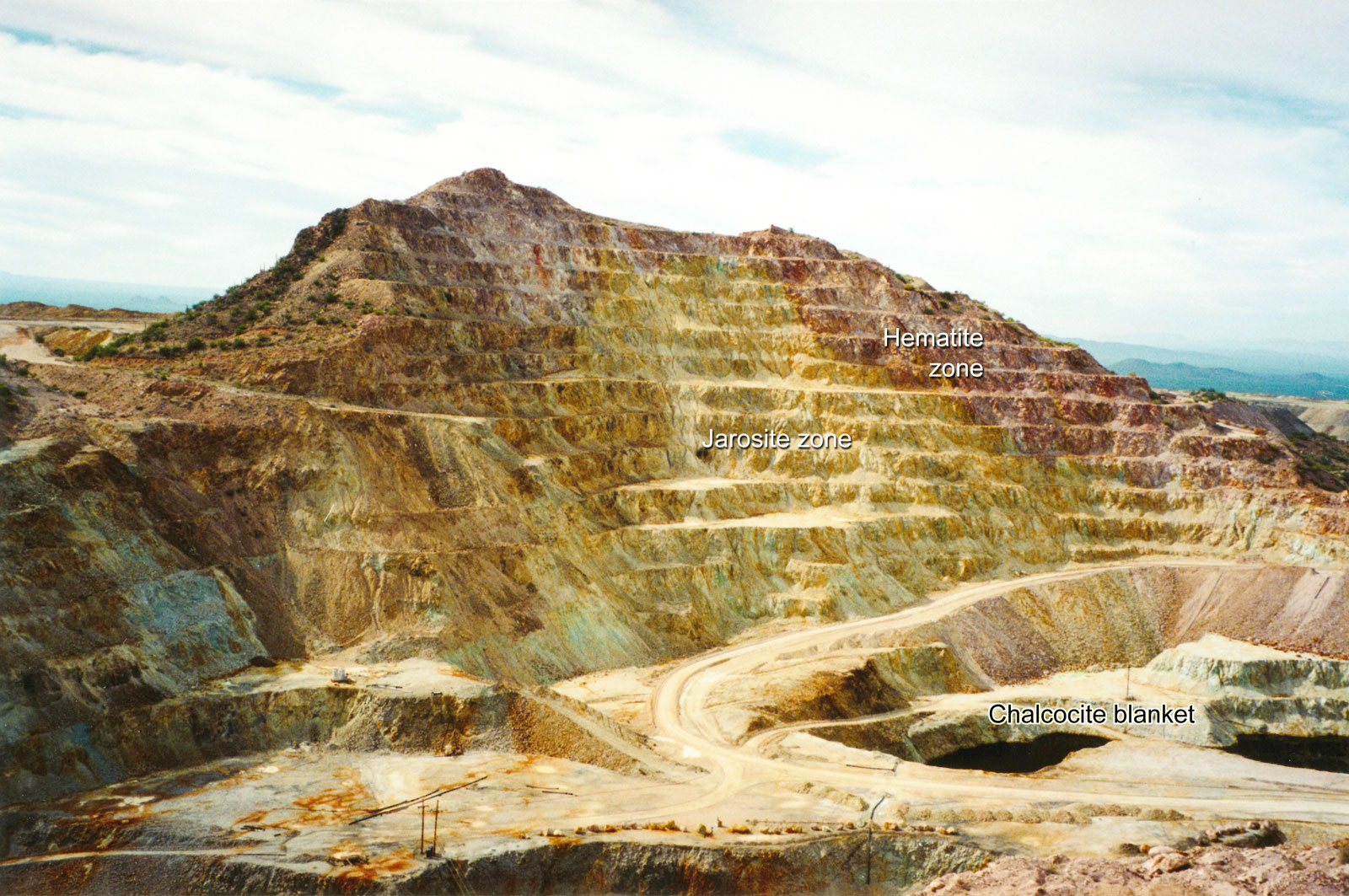
The bulk of the ore mined from the El Tiro pit was present as a 60 m thick (using a 0.4% Cu cutoff), flat lying and tabular supergene enriched sulphide blanket overlain by a 30 m thick remnant leached capping which averaged 300 ppm Cu. The contact between the enrichment blanket and the leached capping is sharp and generally parallels the current surface. Chalcocite enrichment in the porphyries and alaskite was due to pervasive replacement of chalcopyrite and partial conversion of pyrite Copper grades within the enriched zone were relatively uniform and were not zoned relative to hypogene grades, although the copper mineralogy was strongly zoned relative to the hypogene alteration. Chalcocite dominated within zones of pyritic phyllic alteration, while chrysocolla was found, almost to the exclusion of chalcocite, in the absence of phyllic alteration (Graybeal 1982).
Prior to mining at North Silver Bell, the supergene enrichment blanket covered an area of approximately 1.5 sq km, with a tenor of around 15 metre-percent, mostly developed over altered dacite porphyry hosts. Higher grades corresponded to areas of stronger fracture density, reflecting zones of vein controlled quartz-sericite-pyrite alteration where both orthoclase-biotite and phyllic alteration were telescoped and hypogene grades were the greatest. The supergene enrichment blanket lies beneath outcropping goethite-dominant limonite capping developed by weathering and erosion of an originally thicker oxidation profile (Lopez and Titley 1995). According to Lopez and Titley (1995), the current chalcocite blanket represents a second, mature cycle of enrichment which leached an older blanket that occupied a level now marked by hematite capping exposed on ridges and slopes, overlain in turn by goethitic limonites of the older, but less mature cycle of enrichment.
Mature supergene profiles such as those at El Tiro and North Silver Bell, have been developed throughout most of the Silver Bell district and are little disturbed by faulting. Graybeal (1982) concluded that as the top of the enrichment blanket conforms to the modern surface, enrichment occurred in the modern landscape. While Graybeal (1982) noted that clasts of weakly pyritised porphyry with propylitic alteration have been found in Oligocene conglomerates east of the Oxide Pit, implying the upper portions of the orebody may have been in contact with the atmosphere then, this was not evidence of enrichment at that time. He does suggest from field evidence that the chalcocite blankets in the district formed after the emplacement of a Late-Oligocene andesite dyke.
Graybeal (1982) applied a copper mass balance and an estimate of the rate of erosion to calculate that supergene enrichment had occurred over the last 3 m.y. Three supergene dates have been determined from the Silver Bell district. Two are from the Middle Miocene (16.2 ±0.4 Ma and 16.3 ±0.5 Ma), and the third is Pliocene (4.8 ±0.2 Ma). This limited set of results indicates the time interval over which supergene leaching occurred and provides no proof of
continuity, or evidence of interruption.
The summary above is an overview, taken directly from Cook and Porter (2005).
Total production plus reserves/resources at Silver Bell were estimated to be of the order of 267 Mt @ 0.69% Cu, 0.01% Mo (Mutschler et al., 2004).
Total production from 1885 to 1915 - 84.73 Mt @ 1.2% Cu, 2.2 g/t Ag (Keith, 2016; Briggs, 2016 quoted by Briggs, 2017).
Remaining reserves at 31 December, 2015 - 194.50 Mt @ 0.283% Cu (Grupo Mexico, 2016, quoted by Briggs, 2017).
Remaining reserves at 31 December, 2020 - 147.15 Mt @ 0.296% Cu (Grupo Mexico, 2020 Annual Report).
The deposit was owned (in 2021) by ASARCO Inc. a subsidiary of Groupo Mexico.
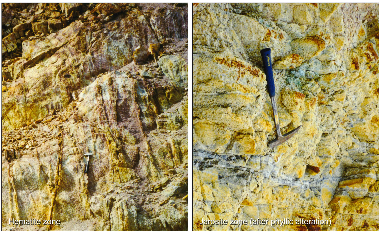
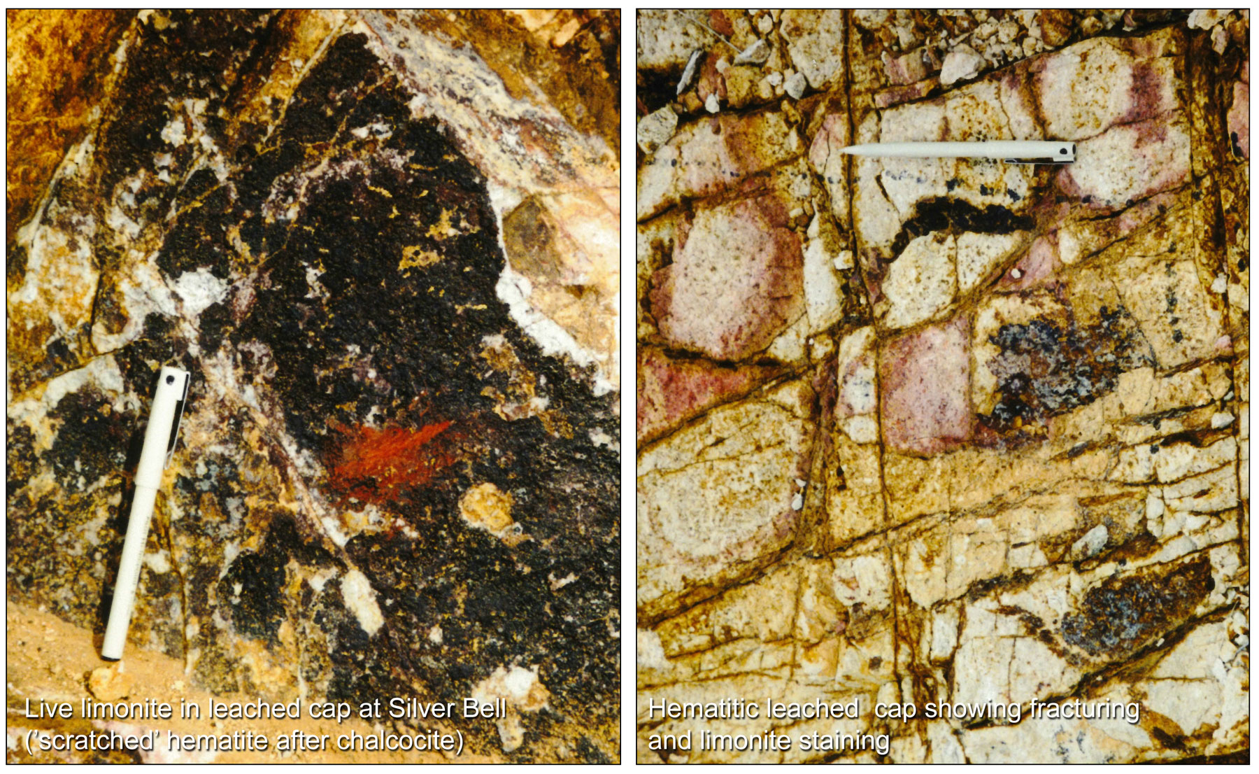
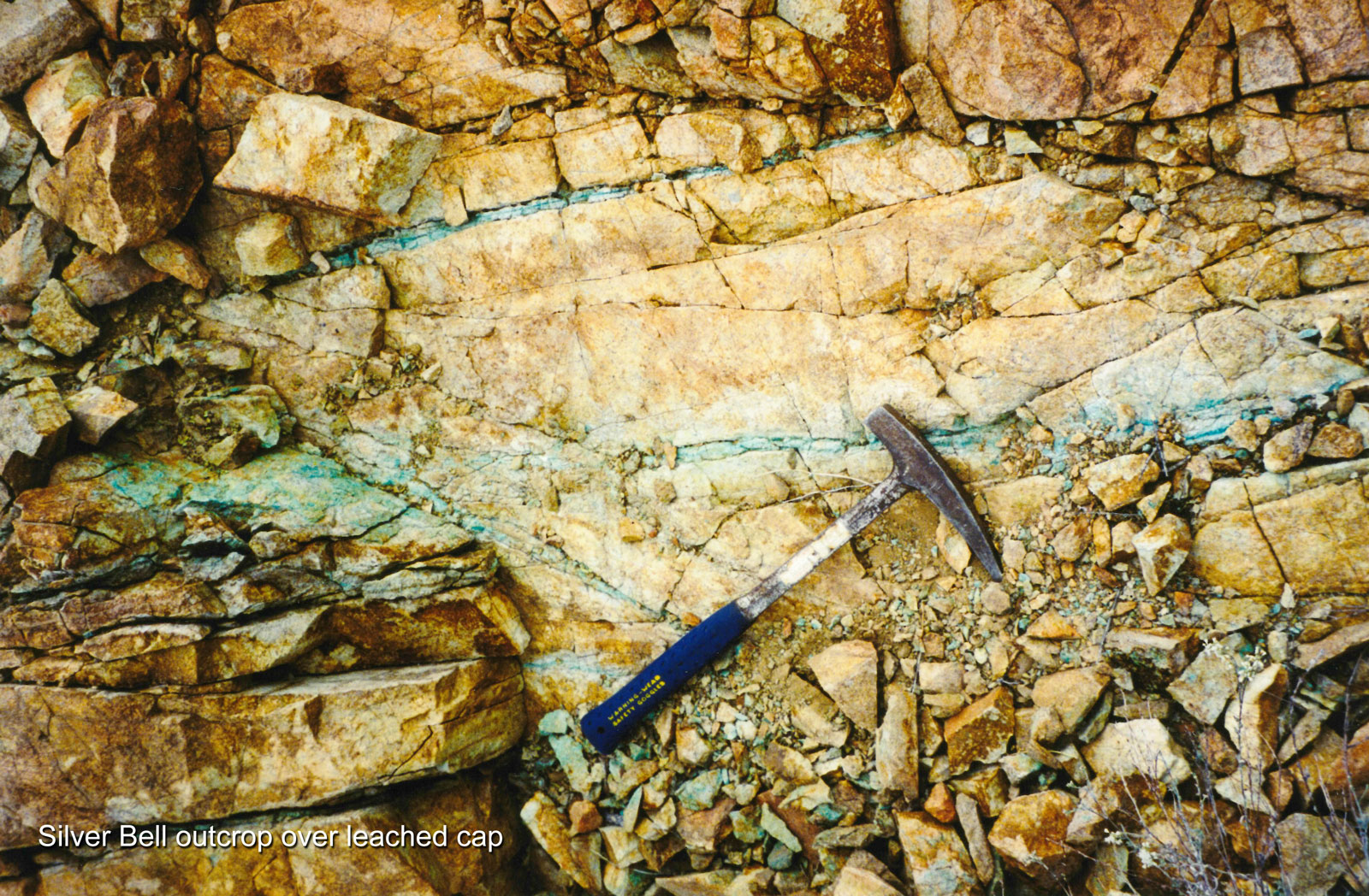
Supergene profile at the El Tiro Pit, Silver Bell - The upper image shows a face of the Silver Bell pit. The profile comprises a hematite stained limonite upper zone, nearest the surface, underlain by a jarosite zone, which is, in turn, underlain below the current to palaeo-water table by the latest and deepest chalcocite blanket. Note the hematite zone has been removed by mining at the top of the hill. Local areas of copper oxides remain within the hematite zone. The second row images show the hematite and jarosite zones, as labelled. Both are developed in phyllic altered protore, being pyrite rich, which facilitates leaching. The third row images are from the mine face, below the original surface. The left image illustrates the distribution of live limonite on fracture faces, with section scratched to reveal it is hematitic, and hence after an earlier, now oxidised chalcocite blanket. The third row right image shows the fracturing which facilitates leaching and downward transport of supergene fluids. The lowermost image is a selected outcrop above the leached cap on the hill to the left. Images by Mike Porter, 1994.


The most recent source geological information used to prepare this decription was dated: 2004.
This description is a summary from published sources, the chief of which are listed below.
© Copyright Porter GeoConsultancy Pty Ltd. Unauthorised copying, reproduction, storage or dissemination prohibited.
Silver Bell district
|
|
|
|
|
Graybeal F T 1983 - Geology of the El Tiro area: in Titley S R 1983 Advances in Geology of the Porphyry Copper Deposits, Southwestern North America University of Arizona Press, Tucson pp 487-505
|
Lopez J A, Titley S R 1995 - Outcrop and capping characteristics of the supergene sulfide enrichment at North Silver Bell, Pima County, Arizona: in Pierce F W, Bolm J G (Eds), Porphyry Copper Deposits of the American Cordillera Arizona Geol. Soc. Digest 20 pp 424-435
|
Richard K, Courtright J H 1966 - Structure and mineralization at Silver Bell, Arizona: in Titley S R, Hicks C L 1966 Geology of the Porphyry Copper Deposits, Southwestern North America University of Arizona Press, Tucson pp 157-163
|
Runyon, S.E., Nickerson, P.A., Seedorff, E., Barton, M.D., Mazdab, F.K., Lecumberri-Sanchez, P. and Steele-MacInnis, M., 2019 - Sodic-Calcic Family of Alteration in Porphyry Systems of Arizona and Adjacent New Mexico: in Econ. Geol. v.114, pp. 745-770.
|
|
Porter GeoConsultancy Pty Ltd (PorterGeo) provides access to this database at no charge. It is largely based on scientific papers and reports in the public domain, and was current when the sources consulted were published. While PorterGeo endeavour to ensure the information was accurate at the time of compilation and subsequent updating, PorterGeo, its employees and servants: i). do not warrant, or make any representation regarding the use, or results of the use of the information contained herein as to its correctness, accuracy, currency, or otherwise; and ii). expressly disclaim all liability or responsibility to any person using the information or conclusions contained herein.
|
Top | Search Again | PGC Home | Terms & Conditions
|
|