|
Telfer |
|
|
Western Australia, WA, Australia |
| Main commodities:
Au Cu
|
|
 |
|
|
 |
Super Porphyry Cu and Au


|
IOCG Deposits - 70 papers
|
All papers now Open Access.
Available as Full Text for direct download or on request. |
|
|
The Telfer gold-copper deposit is located within the Paterson Tectonic Province, in the Great Sandy desert, 400 km ESE of Port Hedland, and 1000 km north of Kalgoorlie, Western Australia (#Location: 21° 43' 18" S, 122° 12' 52" E).
The first recorded indication of the Telfer deposit was the discovery in 1970 of extensive small, low relief quartz-limonite gossans and limonitic siltstones outcropping as pods along lithological contacts by an independent geologist prospecting for copper in the Paterson Range. These gossans were sampled, but were not assayed for gold, and no title was taken. In 1971, Day Dawn Minerals NL undertook a regional sampling program in the district, also without title. Although anomalous copper and gold values were obtained, they were not deemed sufficient to warrant further investigation in the remote location. In mid 1972, Newmont Australia Limited, who were aware of both the original gossan discovery and the Day Dawn anomalies, visited and pegged title over the area. This was followed by sampling and then an intensive drilling program that by 1975 had defined an open pit reserve of 3.8 Mt @ 9.6 g/t Au, mainly of oxide ore. In 1975, BHP Gold Limited was introduced as a 30% joint venture partner in the project to satisfy Australian Government foreign ownership legislation. Later, in 1990, Newmont and BHP Gold merged their Australian assets to form Newcrest Mining Limited that assumed full ownership of the project.
Mining commenced during 1975 at Main Dome and reached full production of 0.5 Mtpa in 1977. Ore processing was initially by milling, cyanidation and Merrill-Crowe gold recovery. During the early 1980s, exploration maintained the high grade reserve, although the potential for a large, low grade oxide resource in both Main and West domes was also recognised and by 1986 the crushing and grinding capacity was enlarged and the Merrill-Crowe process was replaced by a carbon in leach (CIL) circuit. A dump leach operation was commenced in 1988. By the late 1990s, Telfer was treating 2.5 Mtpa through the mill and CIL circuit, and 15 Mtpa of low-grade oxides by dump leach.
In 1989, supergene-sulphide ore was being mined from the base of the oxide zone, initially from the open pit and in 1990, from underground. This required a sulphide flotation circuit to produce a copper and gold concentrate. By the late 1990s, 0.3 Mtpa of this ore was being treated.
In 1991 surface exploration diamond drilling intersected the I30 quartz reef within the Main Dome at 1000 m below surface. A mining feasibility study was completed in 1995 and a decline was commenced that reached ~500 m below surface by July 1997. An underground drilling program ensued, followed by a study of how to best extract the series of deep high grade reefs that were discovered. This work outlined a high grade core reserve in the I30 Reef of 1 Mt @ 15.6 g/t Au, 2.6% Cu, surrounded by a larger tonnage, lower grade gold and copper stockwork. This was, in turn, was part of an even larger underground resource on the eastern limb of the Main Dome associated with an additional eight hanging wall and three footwall reefs, collectively known as Telfer Deeps.
By 2000, the oxide resources were largely exhausted after extracting ~185 tonnes of gold, and mainly hypogene sulphide ore was being mined creating recovery and cost problems. As a consequence, operations were suspended pending feasibility studies into mining hypogene ore in the open pits and Telfer Deeps and modification of the flotation circuit of the existing sulphide treatment plant to accommodate the increased underground reserve and higher sulphide and copper content. In the meantime, the decline to the Telfer Deeps was deepened. The feasibility study was completed in 2002 and production recommenced in the open pits in 2004 and underground in 2006, based on reserves and resources of 320 Mt @ 1.4 g/t Au, 0.14% Cu and 444 Mt @ 1.4% Cu, 0.13% Cu respectively in the open pits and 39 Mt @ 2.7 g/t Au, 0.5% Cu and 59 Mt @ 2.8 g/t Au, 0.52% Cu respectively underground. Resources are inclusive of reserves. The main underground mining method was sub-level caving. Production has continued to the present with only minor operational pauses, for a cumulative total of >150 tonnes of recovered gold. Details in this section are largely drawn from Moorhead et al. (2013) and Newcrest Mining annual reports and releases to the ASX.
Geological Setting
Telfer is located within the NNW to NW trending, >1000 km long by 150 to 200 km wide Paterson Orogen. This orogen fringes the northeastern margin of the Archaean to Palaeoproterozoic West Australian Craton, and merges with the Musgrave Orogen to the SE. It is composed of two main elements, the Rudall Complex and Yeneena Basin. The Rudall Complex comprises ~2015 to 1765 Ma Palaeoproterozoic igneous and sedimentary rocks that were subjected to regional D1 and D2 deformation, metamorphism to granulite facies and granitic intrusion during the ~1800 Ma Yapungku Orogeny, followed by voluminous post-orogenic 1590 to 1310 Ma granitic intrusions only subjected to greenschist facies metamorphism. The complex also includes a domain of sheared peridotite, gabbro, pelitic schist and metaturbidites to the south and east (Bagas, 2004; Whitaker et al., 2010).
The >24 000 km2 Yeneena Basin contains unconformably overlying Neoproterozoic marine sedimentary rocks of the ~9 to 13 km thick Yeneena Supergroup. It represents the extensional, fault controlled, northwestern extremity of the ~2 million km2 Centralian Super-basin, developed where the latter encroached upon the Paterson Orogen. The Yeneena Supergroup is the thickest measured section in the entire super-basin, but only represents the first of four super-sequences contained therein. To the west and SW, it is in fault contact with both stratigraphically equivalent and younger rocks of the Officer Basin section of the Centralian Superbasin that lap onto the West Australian Craton. To the northeast, the Yeneena Basin and Rudall Complex are overlain by the extensive Phanerozoic Canning Basin (Huston et al., 2010).
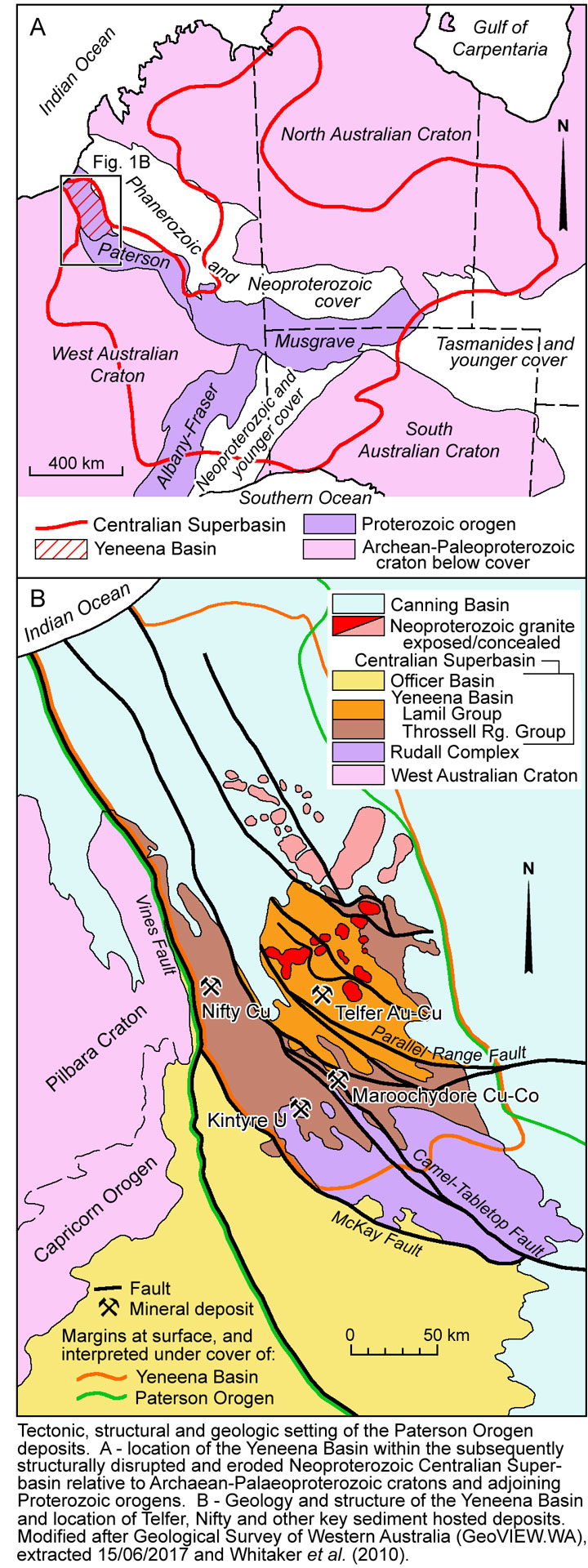
The Yeneena Supergroup is composed of the Throssell Range and overlying Lamil groups. The Throssell Range Group is mainly exposed to the SW of Telfer, although similar rocks to the NE may be equivalents. The lowest unit is the up to 4000 m thick Coolbro Sandstone, predominantly composed of grey, massive and thickly bedded fine- to coarse-grained sandstone. It is conformably overlain by the up to 3000 m thick Broadhurst Formation, a succession of interbedded fine to coarse sandstone to silty shale, including units of dark grey to black carbonaceous siltstone to shale with up to 10% pyrite and pyrrhotite, and stromatolitic dolostone. This unit hosts the ~810 to 790 Ma Nifty and Maroochydore stratabound, sediment-hosted, quartz-dolomite-sulphide vein network copper deposits, 70 km west and 60 km SSW of Telfer respectively.
The Throssell Range Group is structurally overlain by the Isdell Formation, an ~1000 m shelf sequence of fine grained, thinly bedded carbonate rocks, calcareous siltstone, minor shale and local sulphidic dark grey or pale grey-cream carbonate rocks with lesser sandstone. This sequence is conformably overlain by the Lamil Group, which has only been subjected to greenschist facies metamorphism. It comprises a shallow marine sequence, divided into the Malu, Puntapunta and Wilki formations. The Malu Formation, the principal host to ore at Telfer, is up to 2000 m of thickly bedded, fine to medium grained quartzite and quartz sandstone with occasional thin interbeds of siltstone and mudstone. It has a transitional upper boundary with the Puntapunta Formation, 1500 m of laminated to thinly bedded dark grey dolomitic sandstone, dolomitic siltstone, chert, shale and limestone. The Wilki Formation, the uppermost unit of the Lamil Group, consists of up to 1400 m of silicified sandstone and minor shale.
The host to the somewhat similar Winu Cu-Au deposit, 140 km to the NNW of Telfer, has been tentatively correlated with the Malu Formation (Dalstra et al., 2021).
A suite of highly fractionated, I-type granite bodies, the Mount Crofton, Minyari, Wilki and O'Callaghans granites, intrude the Lamil Group. The first three are oxidised, temporally progressing from strongly to more weakly magnetite-bearing granites, emplaced between ~645 and 630 Ma, whereas the 605 Ma O'Callaghans Granite is reduced and ilmenite-bearing (Czarnota et al., 2009; Maidment, et al., 2010). Although no granites are exposed within 5 km of the Telfer deposit, modelling of gravity data suggests large concealed intrusions, including the O'Callaghans Granite, extend beneath Telfer (Schindler et al., 2016). The latter is closely associated with the O'Callaghans scheelite-wolframite skarn altered deposit (Inferred resource of 69 Mt @ 0.34% WO3, 0.55% Zn, 0.27% Pb, 0.29% Cu).
Deposition of the Yeneena Supergroup took place during an ~850 to 824 Ma, NE-SW directed extensional event. Related mafic to intermediate intrusions have been dated at 837 to 815 Ma. Yeneena Supergroup deposition was terminated by basin inversion during the Miles Orogeny between ~820 and 810 Ma (Huston et al., 2010). This event comprises two pulses of regional deformation overprinting the Palaeoproterozoic D1 and D2 fabrics of the Rudall Complex. The first, D3, produced dextral strike-slip and reverse fault reactivation of the prominent NW to NNW trending extensional phase growth faults (e.g., Vines and Camel-Tabletop faults), and recumbent folding in the Throssell Range Group. D4 was responsible for broad folds, conjugate faulting and greenschist facies metamorphism. A progressive 15° anti-clockwise rotation from NNW D3 to NW D4 axes resulted in a series of domal structures, including the Telfer Dome (Bagas, 2004). Widespread mafic dykes and sills were intruded between 750 and 700 Ma, followed by extensive 645 to 605 Ma granitic intrusion. The subsequent Paterson Orogeny involved early D5 open folds and a late D6 episode of NW trending dextral and ENE striking sinistral faults (e.g., Parallel Range and McKay faults) at ~550-540 Ma (Maidment, et al., 2010).
Deposit Geology and Mineralisation
Gold and copper mineralisation at Telfer is concentrated in the core of the NW-SE elongated, 10 x 3 km, Telfer Dome, and is hosted by the Malu Formation, the stratigraphy of which may be summarised as follows:
Malu Quartzite - up to 1000 m of mainly massive and uniform metamorphosed quartz sandstone with increasing quantities of pelitic interbeds at both the top and bottom, indicating gradational contacts with the Isdell Formation and Telfer Member respectively. Much of the quartzite is pyritic and stratabound quartz veins are locally gossanous. The Malu Formation of the Telfer Dome is subdivided as follows, from the base:
• Telfer Member - which is 600 to 700 m thick and is largely a transition zone between the Malu Quartzite and the overlying, mainly carbonate rich Puntapunta Formation. With the Isdell Formation and Malu Quartzite, it is the main Au bearing formation in the region and comprises an alternating sequence of quartzite, siltstone and shale, subdivided into four quartzite and four shale/siltstone units in the Telfer area, as follows, from the base:
- Lower Vale Siltstone, 2 to 5 m thick - thinly bedded and silicified siltstone with disseminated pyrite and siderite.
- Footwall Sandstone, 20 to 50 m thick - commonly poorly sorted quartz sandstone.
- Middle Vale Siltstone, 5 to 9 m thick - fine grained and thin bedded argillaceous siltstone, claystone, mudstone, minor carbonaceous limestone and calcareous sandstone. It is pyritic and the main ore host in the original Telfer open pits hosting the Middle Vale Reef. Abundant shortite pseudomorphs are evident in this unit.
- Median Sandstone, 25 to 40 m thick - poorly stratified and thick bedded, fine grained and well sorted quartz sandstone with silty or muddy interbeds.
- Upper Vale Siltstone, 1 to 4 m thick - thinly bedded sideritic siltstone with minor fine grained sandstones, containing disseminated pyrite in places.
- Rim Sandstone, 30 to 40 m thick - a stratified sequence of interbedded quartz sandstone to subarkose and argillaceous siltstone.
- Outer Siltstone, up to 500 m thick - well stratified, thin bedded, argillaceous, calcareous and minor carbonaceous siltstones with interbedded sandstone. The lower sections host the 'E Reefs' at Telfer. In the Karakutikati Ranges this unit has laminated dolomite and dolomitic shale prominent near the top.
• Upper Malu Member, 620 m of thick-bedded, fine- to medium-grained siliciclastic sandstone; sporadic interbedded carbonate sandstones and carbonaceous
shale/siltstone bands.
• Middle Malu Member, 290 to 320 m of very fine- to coarse-grained sandstone; interbedded with laminated quartz sandstone and siltstone; varying dolostone and
carbonaceous beds.
• Lower Limey Unit, 9 m of bedded fine-to-coarse carbonate sandstone.
• Lower Malu Member, 420 m of turbiditic quartz sandstone; minor siltstone interbeds; carbonaceous towards the top.
 Within the Telfer Dome, this succession has been folded into two asymmetric, en echelon, doubly-plunging anticlines, the Main and West domes, separated by a tight faulted syncline. Both domes have shallow to moderately dipping western and moderate to steep eastern limbs indicating NE vergence in a NE-SW directed compressive stress field during D3 folding. This is the first regional deformation evident at Telfer, and resulted in well-developed cleavage, parallel, or at a low angle, to bedding. This fabric is crenulated by a steeply SW dipping axial plane cleavage. The former is the result of bedding plane slip/shearing during folding, with total displacements of <10 m (Vearncombe and Hill, 1993). This bedding plane slip was strongly partitioned within more ductile siltstone beds and along competence-contrasting sandstone-siltstone contacts. In addition to the folding, shallow NE vergent thrusts formed. Five monocline-anticline structures have been superimposed on the two domes. Each strikes north-south, and is doubly plunging, with axial planes dipping at 35 to 50°W. They are typically up to 1 km in length and 50 to 200 m wide, often with steep east limbs that are locally overturned. A third, weakly developed, ENE trending cleavage, which dips either to the SSE or NNW, is likely related to D4.
 Three different vein styles host gold and copper mineralisation within the Telfer Dome. These are:
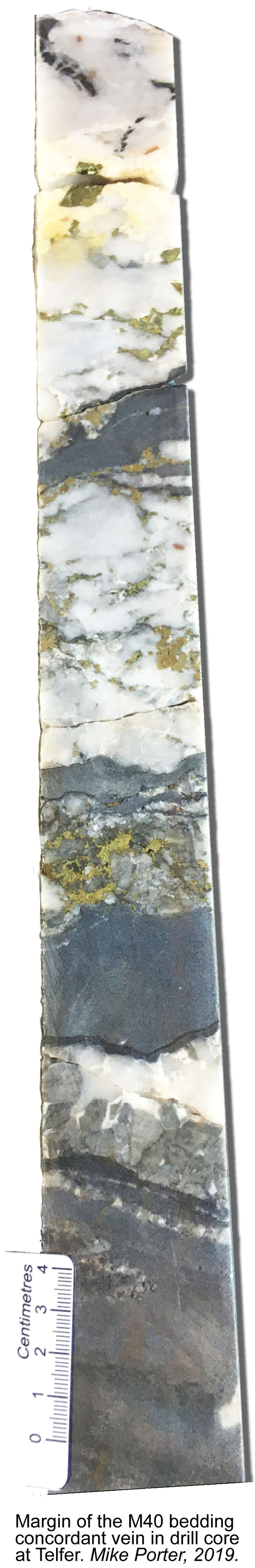
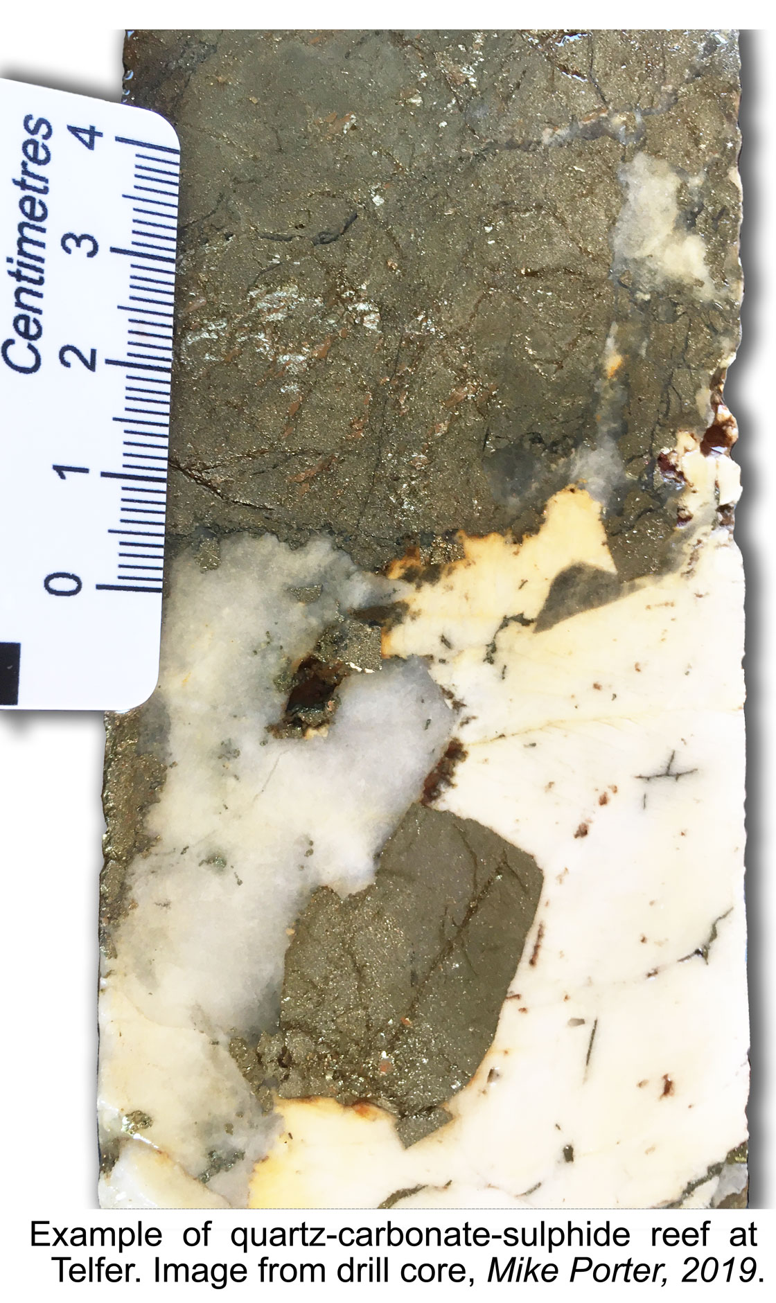 • Bedding-concordant veins, locally termed 'reefs', that are laterally extensive over lengths of up to 1 km or more, both laterally and down dip, and are 0.1 to 10 m, averaging between 0.3 and 0.7 m thick. These reefs follow D3 bedding plane slip shear structures. In the hypogene zone, reefs are composed of quartz±dolomite with sulphide and gold, and traces of scheelite, carrying grades of between 5 and >50 g/t Au, and 0.2 to 1.5% Cu. Average reef grades are frequently >10 g/t Au. The proportion of quartz, dolomite and sulphides is variable, ranging from as much as 80% quartz, to dominantly sulphides within sericite-pyrite shear planes. There is a tendency for a higher proportion of dolomite in the lower reefs, which may be pink, grey or white. A total of 21 reef structures have been identified within the Main Dome, distributed over a stratigraphic thickness of ~1000 m, occurring as either single reefs of sheeted clusters of closely spaced veins. The main upper reefs, the E and Middle Vale reefs, hosted by the basal Outer and Middle Vale siltstones respectively, are planar sheets with surface areas of up to 20 km2, the latter of which averages 1 m in thickness, but ranges up to 3 m. These two reefs extend from the southern Main to the Western Dome. However, Reefs below the Middle Vale are less extensive, and are best developed in the anticlinal crest of the Main Dome, tapering on the flanks of the structure. The next significant vein, the M10, which is 100 m below the Middle Vale Reef in the Upper Malu Member, has a north-south strike length of 2 km and 500 m dip extent, mostly on the eastern flank of the dome. It averages 0.45 m in thickness, ranging from 0.1 on the flanks to 2 m in the axial zone. This is a member of the M-Reefs that are distributed over intervals of <10 to >150 m within the Upper Malu Member. Other M-Reefs illustrate the variation in reef characteristics. The M40 reef, 250 m below M10, is 0.2 to 0.6 m thick carrying 5 to 80, averaging 16 g/t Au, hosted within the Upper Limey Unit which has undergone strong carbonate alteration. The M45 reef, which is 25 m lower, is generally ~2 m thick, and occurs as either a sericite-pyrite shear plane or a quartz-dolomite-sulphide reef, with grade that are typically <10 g/t Au and <1% Cu. The M50 reef, which is 25 m lower, and 300 m below M10, is composed of three separate bands. The upper of these averages 0.2 m in thickness and comprises disseminated sulphides, fine white dolomite and pyrite-chalcopyrite veins within a black, fine- to medium-grained carbonaceous siltstone, carrying 6.4 and 3 g/t Au respectively above and below the base of oxidation. The middle section is a 0.1 to 2.0 m thick quartz-dolomite-sulphide reef as described in other positions, with grades varying between 5 and 94, but averaging 34.6 g/t Au. The lowest band is a 0.2 to 0.5 m thick calcareous sandstone. The A-Reef set is developed within the lower two thirds of the Middle Malu Member, being most densely packed at the base where they may be only a few metres apart, becoming more widely spaced upwards. The most significant in the lower part of the sequence is the I30 Quartz Reef at the contact of the Middle Malu Member and the Lower Limey Unit. It has an area of 875 x 160 m, elongated north south following the crest of the Main Dome, where it is 10 m thick, tapering to ~0.5 m on the flanks of the fold. Mineralisation is dominantly pyrite and chalcopyrite with a gangue of quartz, grey, white and pink dolomite, calcite and rare siderite. The geometry of this reef is controlled by the intersection of the I30 monoclinal fold, a north-south striking reverse fault and a near vertical NE trending fault corridor. The lowest concordant vein set, the B-Reefs, occur as a cluster in the top 75 m of the Lower Malu Member.
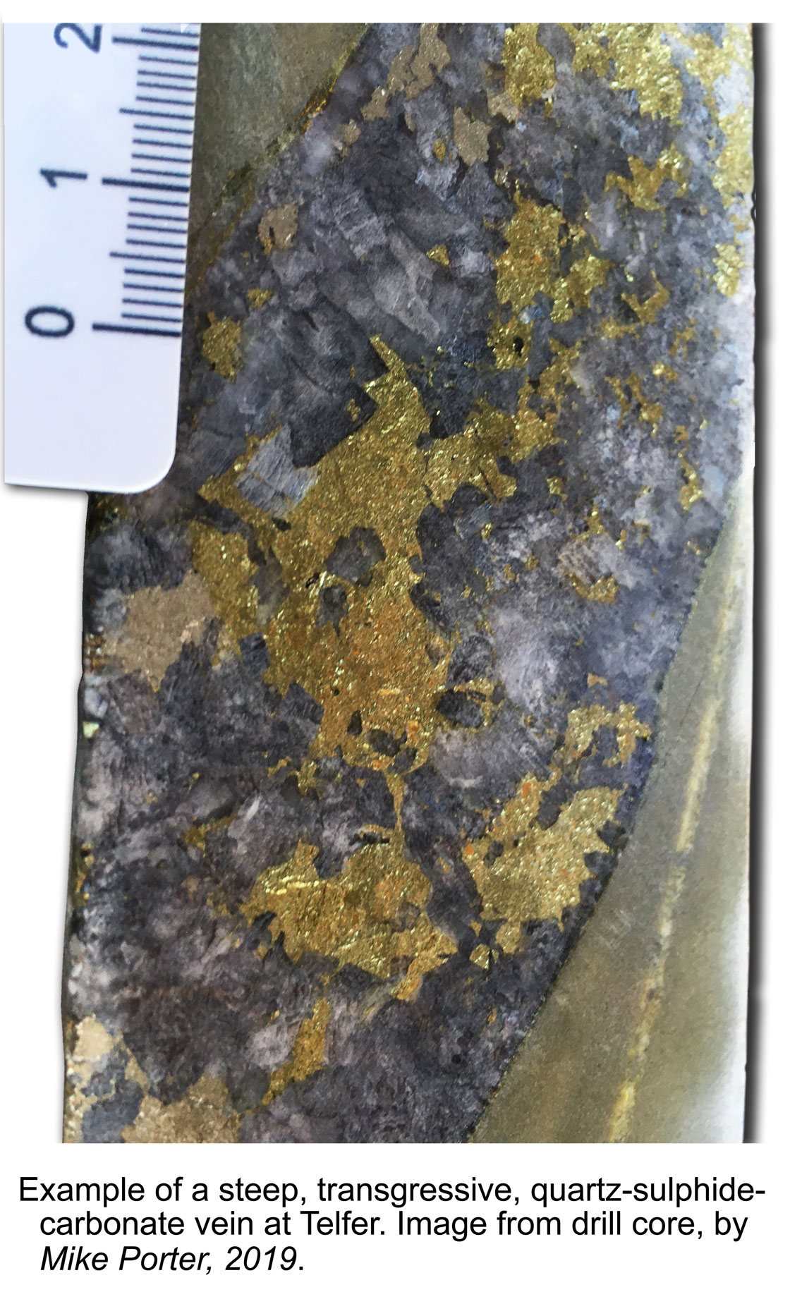 • Veins that are discordant to lithological boundaries, within the axial core of the domes, trending either NE and dipping ~45°NW, or ENE with steep NNW or SSE dips. The former comprise quartz-carbonate-sulphide-gold, and the latter carbonate-quartz-sulphide-gold, with gold and copper grades similar to the reefs. Both contain traces of scheelite. The carbonate is a pink to grey dolomite with minor calcite.
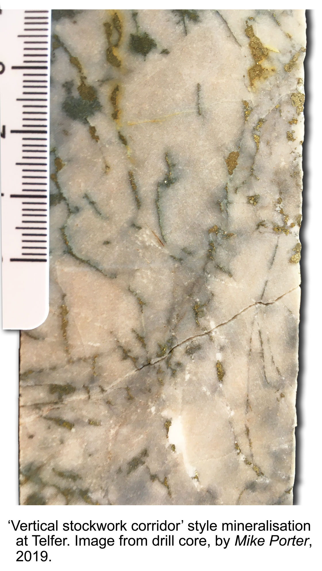
• Breccia and stockwork veining, which forms the bulk of the sulphide resource. Stockwork veins are narrow and discontinuous, cutting across stratigraphy, and are composed of dolomite-quartz-sulphide-gold, forming zones that are characterised by consistent grades of >0.3 g/t Au. The breccias consist of wall rock clasts in a matrix of dolomite-quartz-sulphide-gold. Stockwork mineralisation envelopes and links concordant reefs to form halos with a thickness from a few to as much as 200 m perpendicular to the reefs, with lateral continuities of 100 to 1500 m. These halos are best developed in the axes of the main domes, and pass outwards into patchy zones and pods of stockwork mineralisation. The other principal occurrence is as large, gently SE plunging elongate zones that follow the axial traces of monoclinal structures, and are not closely linked to the main concordant reefs, although intersecting reefs are locally enriched.
Underground mapping shows mutually crosscutting relationship between the different vein types, suggesting several pulses of hydrothermal activity forming alternating reefs, discordant and stockwork veins. The metasedimentary rocks hoating these veins have all been affected by sericitisation, silicification, and lesser carbonate (calcite-dolomite) and tourmaline replacement, which is most intensely developed immediately around the veins and breccias. Sericite-carbonate alteration is most pronounced in argillaceous and carbonate hosts, while silicification is strongest in quartz-rich arenites (Schindler et al., 2016).
Hypogene sulphides are predominantly pyrite and chalcopyrite, with lesser chalcocite and bornite, minor cobaltite and nickel-sulphide. They occur as disseminations and locally as massive zones in quartz and quartz-carbonate veins, and as disseminated blebs and euhedral pyrite crystals replacing sedimentary hosts. Two phases of pyrite growth are recognised. The first is rare subrounded and rounded aggregates of fine euhedral pyrite, possibly of diagenetic origin. It occurs in a thin laminated interval at the top of the Middle Vale Reef, and is overgrown by the dominant coarse-grained subhedral to euhedral epigenetic pyrite found throughout the deposit. Primary gold occurs as free grains on boundaries and crack infill of pyrite and chalcopyrite, in the lattice of pyrite, as Au telluride (calaverite) or Au-Ag telluride (sylvanite), or as electrum inclusions in pyrite, and to a minor degree on gangue silica grains. There is a correlation between vein frequency and gold grade.
 The deposit has been oxidised to depths of from 80 up to 200 m, with an irregular oxide to hypogene boundary, sections of which are occupied by a well-developed supergene enrichment zone. The modern static water table is ~80 m below the surface, and the base of the supergene sulphide zone is at a depth of ~240 to 290 m. Oxidation of primary sulphides to boxwork textured goethite, hematite and other iron oxides is complete throughout the weathered profile, accompanied by variable amounts of vein quartz and clay minerals. Other minerals include monazite, xenotime, magnetite, cuprite, covellite, rutile and zircon. Only minor enrichment of gold appears to have occurred in the oxide zone, although there has been almost total depletion of copper. Minor redistribution of gold occurred near surface with the growth of small nuggets and wire gold in shallow gossans. In addition, erosion of the reefs produced a pediment of alluvial gold in pisolitic laterite and gravels distributed irregularly along the eastern flank of the Main Dome (Dimo, 1990).
The supergene enriched zone contains a complex assemblage of secondary oxide and sulphide minerals, including chalcocite, bornite, chrysocolla, cuprite, tenorite and malachite plus remnant native gold. This ore has similar textures and appearance to the hypogene mineralisation, except that chalcocite has extensively replaced pyrite along grain boundaries and fractures in the supergene zone. On the northeastern flank of the Main Dome, supergene and mixed supergene-oxide ores averaged 27 to 29 g/t Au and 2 to 10 wt.% Cu, whilst the underlying hypogene reef contained 1.6 to 12.8 g/t Au and up to 0.1 wt.% Cu (Dimo, 1990).
Hypogene mineralisation at Telfer post-dates D3 cleavage, as indicated by its control on veining and by euhedral pyrite replacement of minerals forming the cleavage fabric (Rowins et al., 1997). Limits on the age of this deformation event are indicated at the Nifty copper deposit, where mineralisation dated at between 810 and 790 Ma also post-dates D3 cleavage. Monazite and xenotime from Au-bearing concordant and discordant veins at Telfer have been dated at 652±7 and 645±7 Ma respectively, closely coinciding with ages of the oxidised, magnetite-bearing granitic rocks widespread within the district and indicated in gravity data to underlie the deposit at depth (Maidment et al., 2010; Schindler et al., 2016). Fluid inclusions from the various vein types contain five fluid assemblages, with trapping pressures calculated to vary from 3 to <1.5 kbar, homogenisation temperatures of from >480 to <150°C and a mix of salinities from fluids with ~50 and a second suite with 21 to 54 wt.% NaCl equiv.. Other data indicate reduced fluids dominated the system. Fluid inclusions also suggest the three vein types formed from a similar fluid with any vein composition variation reflecting reactions with differing host lithologies. The higher trapping pressure ranges measured exceed calculated lithostatic pressure at the estimated ~5 km Palaeodepth of the deposit at the time of formation, suggesting the ore fluids were over-pressured (Schindler et al., 2016). This is supported by the vein-fault geometry within the deposit which also demonstrates overpressuring.
Goellnicht et al. (1989) and Schindler et al. (2016) suggest the high content of major elements (Na, Mg, K, Ca, Fe, Mn, Cu, Zn, Pb, Co, Ni, Ag, Ce, La, Y and Mo),and high homogenisation temperatures in all fluid inclusion assemblages are compatible with involvement of a magmatic hydrothermal fluid. However, Rowins et al. (1997) present C, O, B, Pb and S isotope data from both ore sulphides and alteration minerals (carbonates and tourmaline) they interpret to indicate ore fluid solutes were derived from sedimentary rocks of the Yeneena Supergroup.
On the basis of these observations, it is postulated metal-bearing magmatic fluids were released into the permeable sedimentary rocks of the Lamil Group, sourced from the large composite granitic body indicated to underlie the district and deposit (Goellnicht et al., 1989; Schindler et al., 2016). These mingled with basinal brines, to be circulated in thermal convection cells, driven by the magmatic heat source, scavenging additional solutes from the host sequence (Rowins et al., 1997). The high temperature, over-pressured hydrothermal fluids collected in the crests of the pre-existing D3-4 Main and West domes, where they permeated bedding plane shears below fine grained aquitards, to hydraulically delaminate and inflate the sequence. During this process, Vearncombe and Hill (1993) estimate that in the Middle Vale Reef, ~40% of the matrix of the siltstone in the shear zone was dissolved and removed. Periodic over-pressure induced fault failure led to sharp pressure release, adiabatic cooling and precipitation of gold, copper, silica and dolomite to form the concordant reefs. The preceding asymmetric NE vergent D3-4 deformation and concentric folding had both enhanced dilation in the bedding plane shears and preferentially fractured competent sandstones on the steeper northeastern limbs of the domal structures. This acted as ground preparation, facilitating access of fluids and providing sites for deposition of the bulk of the concordant, crosscutting vein and stockwork ore. Mineralisation is, in general, best developed in areas of the greatest structural complexity (Schindler et al., 2016).
Reserves and Resources
In 1988 reserves + production accounted for 146 t Au at an average grade of 2.35 g/t Au.
In 1996 open pit resources totalled 92 Mt @ 1.1 g/t Au, while
underground resources were 3.9 Mt @ 11 g/t (indicated) + 7.5 Mt @ 6 g/t Au (inferred).
In 1997, the total measured + indicated + inferred resource was - 173 Mt @ 1.4 g/t Au.
The original mine operated from 1975 to 2000, over which period it produced ~185 t of recovered gold mainly from oxide resources. The redeveloped operation commenced with two open pit mines (Main and West domes) in November 2004 and February 2005 respectively and underground (4 Mtpa) in February 2007 mainly exploiting sulphide ore. Total production from this second period had reached 188 t Au by December 31, 2017.
In June 2005, published reserves and resources totalled (Newcrest reserve statement, 2006):
Total reserves: 360 Mt @ 1.5 g/t Au, 0.18% Cu for 535 t Au,
Total resources: 520 Mt @ 1.57 g/t Au, 0.18% Cu for 815 t Au,
including Open pit - 444 Mt @1.39 g/t Au, 0.13% Cu; Underground 59 Mt @ 2.8 g/t Au, 0.52% Cu; plus satellites and stockpiles.
At the end of June 2011, published reserves and resources totalled (Newcrest website, 2011):
Main Dome open-pit reserves: 240 Mt @ 0.80 g/t Au, 0.10% Cu for 190 t Au,
West Dome open-pit reserves: 190 Mt @ 0.64 g/t Au, 0.06% Cu for 120 t Au,
Underground reserves: 46 Mt @ 1.3 g/t Au, 0.33% Cu for 59 t Au.
TOTAL gold in reserves in June 2011 was 369 t.
Main Dome open-pit resources: 390 Mt @ 0.66 g/t Au, 0.08% Cu for 260 t Au,
West Dome open-pit resources: 370 Mt @ 0.50 g/t Au, 0.05% Cu for 185 t Au,
Underground resources: 100 Mt @ 1.2 g/t Au, 0.31% Cu for 120 t Au.
Other resources resources: 16 Mt @ 0.42 g/t Au, 0.33% Cu for 6.2 t Au,
TOTAL gold in resources in June 2011 was 575 t.
Ore Reserves are included within Mineral Resources.
Remaining Ore Reserves and Mineral Resources at 31 December, 2016 were (Newcrest Mining, 2017):
Main Dome open-pit reserves: 30 Mt @ 0.61 g/t Au, 0.097% Cu for 18.3 t Au,
West Dome open-pit reserves: 78 Mt @ 0.67 g/t Au, 0.060% Cu for 52.3 t Au,
Underground reserves: 19 Mt @ 1.4 g/t Au, 0.24% Cu for 26.6 t Au.
TOTAL reserves: 127 Mt @ 0.77 g/t Au, 0.10% Cu for 98 t Au.
Measured resources
Main Dome open-pit: 16 Mt @ 0.4 g/t Au, 0.1% Cu,
Indicated resources
Main Dome open-pit: 49 Mt @ 0.83 g/t Au, 0.070% Cu,
West Dome open-pit: 180 Mt @ 0.61 g/t Au, 0.065% Cu,
Underground: 84 Mt @ 1.20 g/t Au, 0.28% Cu,
Inferred resources
Main Dome open-pit: 0.27 Mt @ 0.65 g/t Au, 0.056% Cu,
West Dome open-pit: 7.7 Mt @ 0.60 g/t Au, 0.075% Cu,
Underground: 18 Mt @ 1.50 g/t Au, 0.44% Cu,
TOTAL resources: 355 Mt @ 0.82 g/t Au, 0.14% Cu for 291 t Au.
NOTE: Resources are inclusive of reserves.
The most recent source geological information used to prepare this decription was dated: 2016.
Record last updated: 14/8/2017
This description is a summary from published sources, the chief of which are listed below.
© Copyright Porter GeoConsultancy Pty Ltd. Unauthorised copying, reproduction, storage or dissemination prohibited.
Telfer
|
|
|
|
|
Anonymous 1998 - Telfer (Newcrest): in Register of Australian Mining 1997/98 pp169-170
|
Dimo G 1990 - Telfer Gold deposits: in Hughes F E (Ed.), 1990 Geology of the Mineral Deposits of Australia & Papua New Guinea The AusIMM, Melbourne Mono 14, v1 pp 643-651
|
Howard, G R, Hansen, T, Moore, C, Moffitt, P J, Inglis, R J, Carlson, R D, Kirchner, I, Coupland, D, Leary, S and Tomsett, A, 2000 - Current Geological Understanding of Telfer Gold Mine: in 4th International Mining Geology Conference, Coolum, Qld, 14 - 17 May 2000 Conference Proceeings, pp. 135-142.
|
Maidment, D.W., Huston, D.L. and Beardsmore, T., 2017 - Paterson Orogen geology and metallogeny: in Phillips, G.N., (Ed.), 2017 Australian Ore Deposits, The Australasian Institute of Mining and Metallurgy, Mono 32, pp. 411-416.
|
Maidment, D.W., Huston, D.L. and Heaman, L., 2010 - The age of the Telfer Au-Cu deposit and its relationship with granite emplacement, Paterson Province, Western Australia,: in Geoscience Australia Profession Opinion 2010/05, pp. 1-36.
|
Porter, T.M., 2017 - Telfer gold-copper deposit: in Phillips, G.N., (Ed.), 2017 Australian Ore Deposits, The Australasian Institute of Mining and Metallurgy, Mono 32, pp. 417-421.
|
Rowins S M, Groves D I, McNaughton N J, Palmer M R, Eldridge C S 1997 - A reinterpretation of the role of granitoids in the genesis of the Neoproterozoic gold mineralisation in the Telfer Dome, Western Australia: in Econ. Geol. v92, no. 2 pp 133 -160
|
Rowins, S.M., Groves, D.I. and McNaughton, N.J., 1998 - Neoproterozoic Telfer-style Au (Cu) deposits: in AGSO J. of Aust. Geol. & Geophys. v.17 pp. 217-223
|
Schindler, C., Hagemann, S.G., Banks, D., Mernagh, T. and Harris, A.C., 2016 - Magmatic Hydrothermal Fluids at the Sedimentary Rock-Hosted, Intrusion-Related Telfer Gold-Copper Deposit, Paterson Orogen, Western Australia: Pressure-Temperature-Composition Constraints on the Ore-Forming Fluids: in Econ. Geol. v.111, pp. 1099-1126.
|
Vearncombe, J.R. and Hill, A.P., 1993 - Strain and displacement in the Middle Vale Reef at Telfer, Western Australia: in Ore Geology Reviews v.8, pp. 189-202.
|
|
Porter GeoConsultancy Pty Ltd (PorterGeo) provides access to this database at no charge. It is largely based on scientific papers and reports in the public domain, and was current when the sources consulted were published. While PorterGeo endeavour to ensure the information was accurate at the time of compilation and subsequent updating, PorterGeo, its employees and servants: i). do not warrant, or make any representation regarding the use, or results of the use of the information contained herein as to its correctness, accuracy, currency, or otherwise; and ii). expressly disclaim all liability or responsibility to any person using the information or conclusions contained herein.
|
Top | Search Again | PGC Home | Terms & Conditions
|
|


