|
Kupferschiefer-Zechstein, Lubin, Rudna, Sieroszowice, Polkowice, Glogow, Konrad, Lena, Nowy Kosciol |
|
|
Poland |
| Main commodities:
Cu
|
|
 |
|
|
 |
Super Porphyry Cu and Au


|
IOCG Deposits - 70 papers
|
All papers now Open Access.
Available as Full Text for direct download or on request. |
|
|
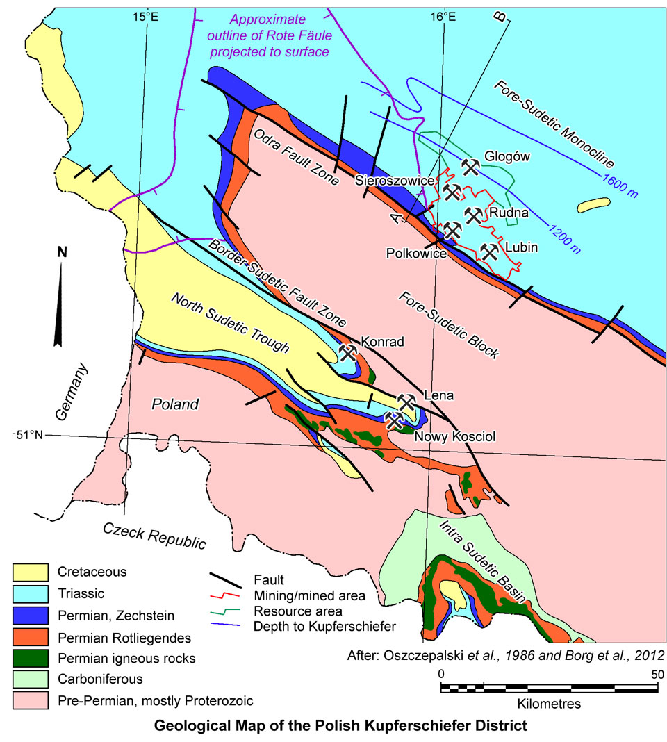
The Lubin, Rudna, Sieroszowice, Polkowice and Glogów, and the Konrad, Lena and Nowy Kosciol copper mines are located within two troughs that are 30 km apart to the NE and SW respectively of the NW-SE trending Fore-Sudetic Block in south-western Poland. The first group extend over a 20 km long NW-SE trend within the Fore-Sudetic Monocline, immediately to the north of the town of Lubin, while the second group occur over a ~15 km, similarly trending strike length, in the North-Sudetic Syncline, 25 km to the SW. Both groups exploit ore within the Permian Rotliegendes/Kupferschiefer/Zechstein sequence.
The copper deposits flanking the Fore-Sudetic Block in southwestern Poland represent the geological extension of the Kupferschiefer of Germany, which has been mined for copper since the twelfth century. The deposits currently being mined in the area by KGHM were discovered in 1957 by deep drilling on a 3 x 3 km grid pattern, led by the Polish Geological Institute of Warsaw, although mineralisation had previously been known in the North Sudetic Trough. This drilling program was completed in 1959. Shaft sinking commenced at the Lubin, Polkowice, Rudna and Sieroszowice mines in 1960, 1963, 1970 and 1977 respectively, with production from each initiated in 1968, 1969, 1974 and 1980.
In 1961, the Mining, Smelting and Refining Industrial Combine was established to develop the mines, smelters and refineries to exploit the extensive resources thus identified. In 1991, the Industrial Combine was restructured into a state-owned joint-stock company, under the name KGHM Polska Miedź S.A., then in 1997 privatised, with shares listed on the Warsaw stock exchange, and Global Depositary Receipts (GDR) on the London stock exchange. Subsequently the ownership has been restructured and in 2013 is owned 32% by the Government of Poland, 39% by foreign institutional investors, 25% by Polish institutional investors and 4% by private investors.
Regional Setting
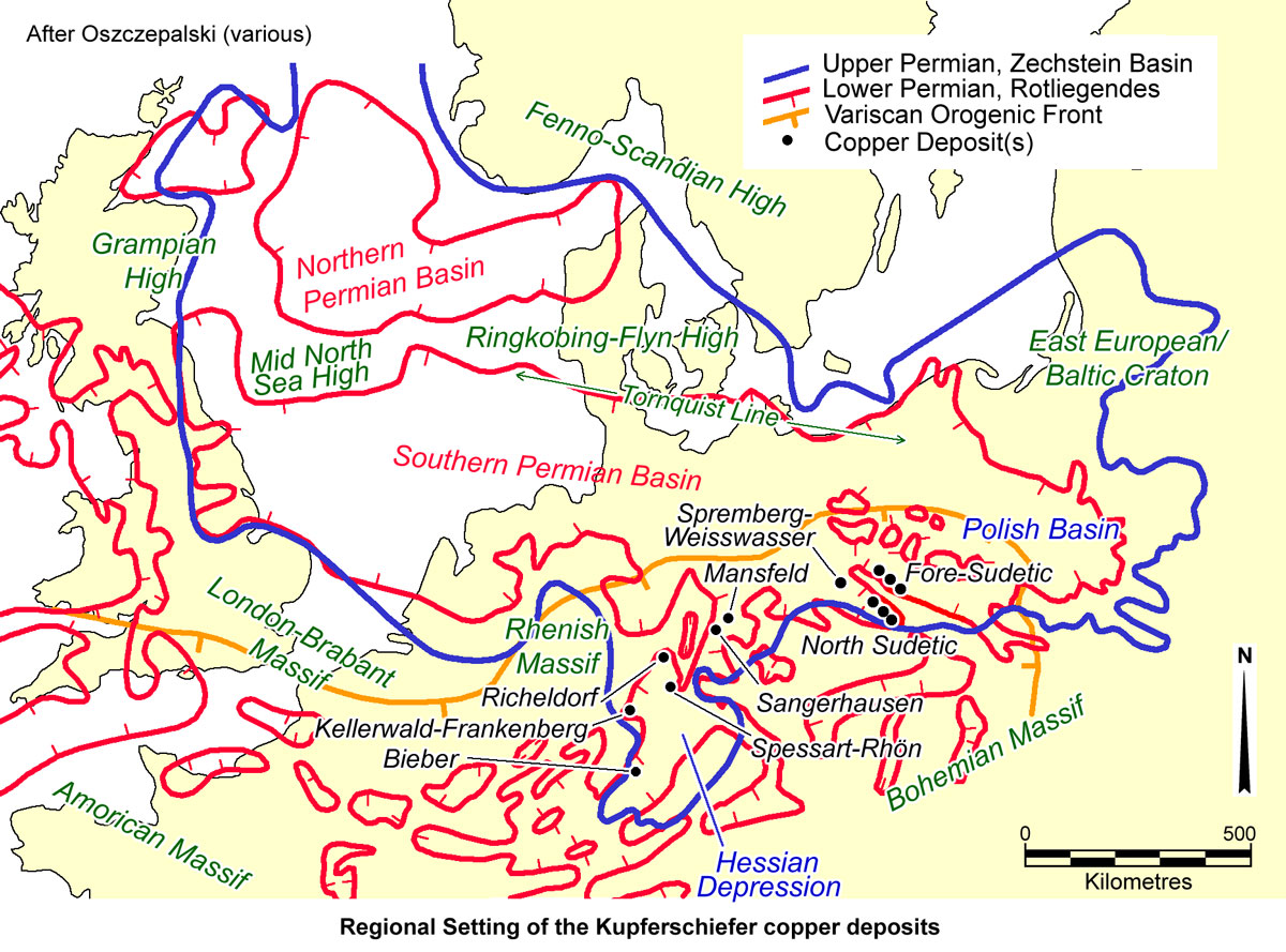
The Polish Kupferschiefer mineralisation is developed on the south-western margin of the Polish Trough, a basin that forms the south-eastern section of the Southern Permian Basin, which extends across northern Europe, from the North Sea, through northern Germany, to Poland. It is bounded to the north-east, along its common margin with the Precambrian rocks of the East European/Baltic Craton and Fenno-Scandian High, by a major structural zone, the Tornquist Line. To the south east, sediments of the basin lap onto the Rhenish and Bohemian Massifs, along block faulted margins characterised by a series of parallel horsts and grabens forming basement highs and embayments. The major copper deposits are found on this latter margin.
In the latest Carboniferous and earliest Permian (~300 Ma), the relative dextral motion between the European and African plates produced a stress field with east-west maximum extension in the region of the Variscan Orogen and its foreland. This, in turn, formed a large conjugate shear fault system (Arthaud and Matte, 1977; Ziegler, 1990), with faults striking predominantly NW-SE and NNE-SSW, as well as a series of large and small transtensional pull-apart basins. The shearing is interpreted to have opened deep pathways for the ingress of magma and the extrusion of volcanic rocks (Borg et al., 2012). The magmatism was typically bimodal (Eckardt, 1979), with mafic magmas produced by upper mantle decompression melting, and felsic magmatism from partial anatexis of lower continental crust. The principal depocentre was the SSW-NNE trending Central European Basin in northeastern Germany, with up to 3 km of rhyolitic and basaltic to andesitic volcanic rocks, as well as terrestrial clastic sediments of the Lower Rotliegendes, deposited in this basin and pull-apart troughs on its southern margin (Plein, 1995; Breitkreuz and Kennedy, 1999). The influence of crustal heating and extension during this period produced regional thermal uplift and erosion, manifested by the unconformity between the Lower and Upper Rotliegendes (Ziegler, 1990; Bachmann and Hoffmann, 1997).
The overlying Upper Rotliegendes of the late Early to Late Permian, was characterised by thermal subsidence of the basin, with subordinate extension (Gast, 1988). During the late Permian, the main depocentre of Upper Rotliegendes sediments was within northwestern Germany, in the hydrologically closed WNW-ESE trending Southern Permian Basin, which was then in a zone of arid climate (Ziegler, 1990). A large playa system developed, in which a more than 2 km thick terrestrial sequence of red beds and evaporites of the Upper Rotliegendes was deposited, punctuated by occasional tectonic pulses which caused unconformities and some basaltic volcanism (Plein, 1995). A few brief marine ingressions took place in the uppermost Rotliegendes, following the same seaway connection to the Boreal Sea as the subsequent Zechstein transgression (Littke et al., 2008).
By the close of the Permian (Wuchiapingian), continued thermal subsidence had resulted in the depression of the basin floor to well below (200 to 300 m) sea level, and hence the subsequent ingression of the Zechstein Sea from the Boreal Sea is interpreted to have been rapid and catastrophic (Glennie and Buller, 1983), flooding the basin with seawater (Ziegler, 1990). This flooding was followed by deposition of the almost basin-wide, typically 0.3 to 0.6 m thick, black, bituminous and carbonaceous, laminated marine shale or marl, deposited in anoxic, euxinic bottom waters, that constitutes the Kupferschiefer. The overlying, more than 1.5 km thick, Zechstein basin fill sequence resulted in shallowing, and is characterised by up to eight major evaporite cycles precipitated in the continuing arid climate (Littke et al., 2008).
The Zechstein Basin subsided and was significantly expanded during the Triassic, due to thermal sag and a further period of extension, heralding the break-up of Pangea and the opening of the Tethys Ocean to the south. This produced local SSW-NNE trending grabens, depressions and swells, as well as diapirs of the underlying Zechstein salt (Doornenbal and Stevenson, 2010). The basin was filled with >1.5 km of continental fluvial clastic and playa, to restricted marine sedimentary rocks, represented by the Buntsandstein (Bunter Sandstone), several hundred metres of open-marine carbonate and evaporite rocks (the Muschelkalk), and the restricted marine Keuper dolostone, shales/claystones and evaporites, punctuated by repeated tectonic pulses which caused significant unconformities (Jowett, 1986).
The break-up of Pangea in the Jurassic, resulted in shallow seas covering the Central European Basin. During the Late Jurassic (~150 Ma), wrench tectonics uplifted and reactivated the WNW-ESE trending London-Brabant-Bohemia Swell and the smaller Lusitania Swell to the northeast (Ziegler, 1990). Borg et al. (2012) note that several of the Kupferschiefer mining districts (e.g., the Richelsdorf, Mansfeld-Sangerhausen, Spremberg/Weisswasser districts and the North-Sudetic trough) are located close to the northern hinge zones of these uplifted swells. Major NW-SE as well as NNE-SSW trending, crosscutting fault zones dissected the swells, accommodating differential lateral crustal movement. The crustal uplift in the southeast and renewed subsidence in the northwest, caused tilting of crustal blocks and, as a consequence, may have allowed large-scale lateral and vertical fluid migration along major fault zones and suitable lithologic aquifers.
 Geology
The Kupferschiefer mineralisation in Poland and Germany is hosted by a sequence which may be summarised as follows, from the base:
Pre-Permian Basement - composed of crystalline schist, greywacke, hornfels, granodiorite and gneiss of Proterozoic to upper Palaeozoic age (Kłapcinski et al., 1975; Tomaszewski, 1978), including Devonian argillaceous limestone, black shale and calcareous clastic sedimentary rocks, and widespread, deep water, Lower Carboniferous volcanic pyroclastic activity, accompanied by the intrusion of granites, syenites and granite porphyries, and Upper Carboniferous coal measures. The volcanic and intrusive rocks belong to a magmatic arc developed along the south-western margin of the Polish Trough, associated with the Devono-Carboniferous Variscan Orogeny.
Unconformity
Lower Permian - commencing with extensional tectonics, down-warping and deposition of:
* Basal Clastic Rocks, up to 150 m in thickness - two reddish-brown conglomerate-sandstone-mudstone sequences.
* Bi-modal volcanic rocks, from a few, to >250 m thick in the mining area to as much as 1500 m a little further to the north - representing strong volcanic activity between 285 and 270 Ma on the southern basin margin of the Southern Permian Basin in the Fore-Sudetic Monocline, North Sudetic Trough and NW Poland. These are alkaline volcanics, composed of tholeiitic basalt, trachy-basalt, rhyodacite and rhyolitic tuffs and lavas, deposited in two cycles, each starting with basaltic melaphyre, and ending with felsic porphyries and tuffs (Kucha and Piestrzynski, 1995).
* Rotliegendes Clastic Rocks - deposited in what started as a series of isolated, elongate, fault controlled basins, and developed in time into north-west trending, partially inter-connected, 'basin and range' depositories. These basins contain clastic facies, mainly red sandstones and conglomerates, which were deposited in alluvial fan, braided river, meandering stream, aeolian and saline lake environments, but also includes aeolian to dune sands, in the upper parts of the section. By the end of the Rotliegendes deposition, the small basins had merged into a series of larger, interconnected basins, separated and bounded by topographic basement highs (Kucha and Piestrzynski, 1995).
The sequence is up to 500 m thick in the Lubin area, and is divided by an unconformity into the Lower and Upper Rotliegendes. The Lower Rotliegendes clastic rocks are generally <200 m in thickness and coarser, with a higher proportion of conglomerates, and are intercalated with the bimodal volcanic rocks.
The Upper Rotliegendes is more extensive, with an overall thickness usually of ~200 m, increasing locally to 600 m (Blundell et al., 2003). It is divided into two megacycles of basal sandstone and conglomerate, ending with fine-grained sandstones on the basin margins, and claystone and siltstone in the basin centres, but is overall finer than the Lower Rotliegendes, being predominantly sandstones (Oszczepalski et al., 1986; Kucha and Piestrzynski, 1995). The conglomerates contain clasts of the underlying volcanic rocks, as do those of the Lower Rotliegendes also. The sandstones are fine to medium grained, moderately well sorted, subangular, and contain 80% quartz and 20% feldspar, with a matrix of carbonate, gypsum and clay. The deposition of the Upper Rotliegendes considerably levelled the basin floor and basement high relief (Oszczepalski et al., 1986). Natural gas reservoirs are found in central and southwestern Poland, within the Upper Rotliegendes, capped by the Kupferschiefer shale (Kucha and Piestrzynski, 1995).
The uppermost sections of the Rotliegendes, over a thickness generally of up to several metres, but locally as much as 65 m (Oszczepalski, 1989), has been bleached and chemically reduced to a white or grey colour, referred to as the Weissliegendes and Grauliegendes respectively (Borg et al., 2012). In detail, the Weissliegendes, which in the mining area of the Fore-Sudetic Monocline locally varies from a few to 35 m, averaging 18 m, comprises aeolian, fluvial, and locally, marine sandstones, that remained white due to insufficient oxidation and hematitic reddening, before they were abruptly capped by the reduced Kupferschiefer (Ehling et al., 2008). It lacks hematite and goethite, has an average Total Organic Carbon content of 0.4%, and locally contains sulphides (Kucha and Piestrzynski, 1995; Kucha and Mayer, 2007). Lithologically, it is predominantly composed of quartz, feldspar and lithic fragments of crystalline basement rock, commonly as angular grains cemented by clay, carbonate-clay, clay-carbonate, anhydrite, and carbonate-clay-sulphide (Borg et al., 2012). The uppermost section of the Weissliegendes, which is commonly more carbonaceous, is composed of quartz arenite and conglomerates, with carbonate and/or anhydrite cement, and was partially reworked during the transgression of the Zechstein Sea, representing the basal Zechstein unit (locally known as the Zechstein Konglomerat). This zone of reworking is usually 1 to 6 m thick, but may occasionally be up to 20 to 40 m. The upper surface of the Weissliegendes is locally irregular, forming a series of elongate ridges that served as highs that penetrate the Kupferschiefer. These highs or ridges are interpreted to represent sand dunes (Jowett, 1991) or sandbars (Borg et al., 2012). Where the Kupferschiefer is absent and the Weissliegendes dunes are overlain by the Zechstein carbonates and evaporites, the sandstone is impregnated with anhydrite nodules and the sulphates dispersed through the rock, forming what is known as the Anhydrite Zone (Kucha and Piestrzynski, 1995).
The light grey, locally grey-pink, Grauliegendes sandstones and conglomerates, in contrast, had undergone terrestrial oxidation and hematitic reddening, but were subsequently bleached (i.e., chemically reduced) due to the flooding and reaction with the overlying stagnant, euxinic Kupferschiefer Sea, and with chemically reducing basin and pore fluids/hydrocarbons. The boundary between the Rotliegendes and Weissliegendes/Grauliegendes is gradational, diffuse, irregular and transgressive.
Upper Permian - Zechstein Sequence, which is up to 500 m thick over the Fore-Sudetic Block, 250 to 500 m in the Lubin area, and up to 1500 m in the main basin to the north. This sequence is composed of four evaporitic cyclothems. PZ-1 to 4, all of which are represented in the Fore-Sudetic Monocline, except in the southernmost part, where cycles 2 and 4 are absent (Peryt, 1978; Oszczepalski et al., 1986). Similarly, all cycles are present within the northern part of the North Sudetic Basin, while cycles 2 and 4 pinch-out to the south (Oszczepalski et al., 1986). The Zechstein Sequence is more continuous laterally and more widespread than the underlying Rotliegendes, lapping onto adjacent basement. It comprises:
PZ-1, Zechstein Cyclothem 1
* Basal Limestone or Border/Boundary Dolomite, generally 0 to 0.3 m thick - a discontinuous thin bed which is up to 10 cm thick in the Lubin district and is restricted to the basin margin, pinching out down dip to the northeast (Oszczepalski, 1989). The Boundary Dolomite is developed in the eastern part of the Fore-Sudetic Monocline deposits as a continuous and solid layer, but only occurs locally as lenses in the western part (Borg et al., 2012). In the Konrad District of the North Sudetic Basin to the south however, it may be up to 7 m in thickness (Oszczepalski, 1999). It is composed of bioclastic mudstone, organic-bearing biomicrites, sandy micrites and oncolites and locally as packstone and grainstone, rich in skeletons of foraminifera, brachiopods and ostracod skeletons (Kucha and Piestrzynski, 1995; Oszczepalski, 1999; Borg et al., 2012).
* Kupferschiefer, generally 0 to 70 cm thick, rarely exceeding 1 m, but averaging 0.27 m in the Fore-Sudetic Monocline deposits. This bed is generally accepted to have been deposited at ~255 Ma (between 247±20 and 260.4±0.4 Ma; Borg et al., 2012 and sources cited therein), and covers an area of approximately 600 000 km2 within northern Europe. It generally overlies either a thin Zechstein conglomerate developed at the base of the Kupferschiefer, the Basal Limestone or the Weissliegendes, and rarely the Rotliegendes volcanic rocks.
Tectonically crumpled, pitchy, shales are frequently found at the base. It is composed in general of a lower, up to 10 cm thick layer of laminated, black, organic rich, clayey-shale, overlain by up to 40 cm of laminated clayey-dolomitic shale, followed by an upper band, up to 40 cm thick, of more dolomitic clayey-shale with an increasing calcareous component. The lower and upper boundaries correspond to the transition from the microlaminated Kupferschiefer to the non-laminated enclosing sediments.
The metal-bearing black microlaminated shale that comprises the Kupferschiefer is typically composed of clays (mainly illite with minor montmorillonite, kaolinite and chlorite), dolomite, organic matter (94% kerogen and 6% bitumen), sulphides, calcite and minor phosphates, gypsum, anhydrite, with clastic components, such as quartz, different types of mica and titanium oxides. The laminites are made up of varying proportions of light argillaceous and carbonate laminae alternating with dark laminae of organic, argillaceous and carbonate material. Iron sulphides or iron oxides are usually present also. It contains both an organic rich and carbonatic, organic poor facies.
The average total organic carbon (TOC) content is 7.34% (Oszczepalski, 1999; Borg et al., 2012). The organic matter is predominantly of the marine type of kerogen II, with lesser kerogen I, and only minor amounts of kerogen III (Kirst, 1994; Więcław et al., 2007). Fossils within the Kupferschiefer include continental plants and trees (which decrease upwards), freshwater to near-shore brackish shells and marine fish (which increase upwards). These observations are taken to infer that the Kupferschiefer represents a transgressive event that progressed from a peri-marine coal swamp or lagoonal environment into a shallow-marine, intertidal to subtidal environment (Jowett, 1992).
Pyrite is the dominant "background" sulphide away from the mineralised zones, comprising 2 to 4 vol.%, occurring as disseminated subhedral grains, spheroids, framboids and lenses (Rydzewski, 1969; Oszczepalski and Rydzewski, 1987). The framboids comprise 5 to 30 µm clusters of 0.5 to 2.0 µm spheroids, which are intimately associated with organic matter in the shale matrix (Rydzewski, 1969), and also in the immediately overlying marine carbonate rocks (Jowett, 1992).
The black fissile shales of the Kupferschiefer are absent over several northwest-trending elevations of the underlying Weissliegendes, and the sandstones along these elevations are directly overlain by limestones and dolostones. Where present, the mineralised black fissile shales of the Kupferschiefer pass laterally westwards across an oxidation front into the Rote Fäule zone. The Rote Fäule, is characterised by the absence of copper sulphides and by 'splotchy' hematite staining that overprints the Kupferschiefer and all other host units, destroying, leaching and oxidising the carbonaceous sediments and pre-existing sulphides, leaving only refractory and immobile constituents.
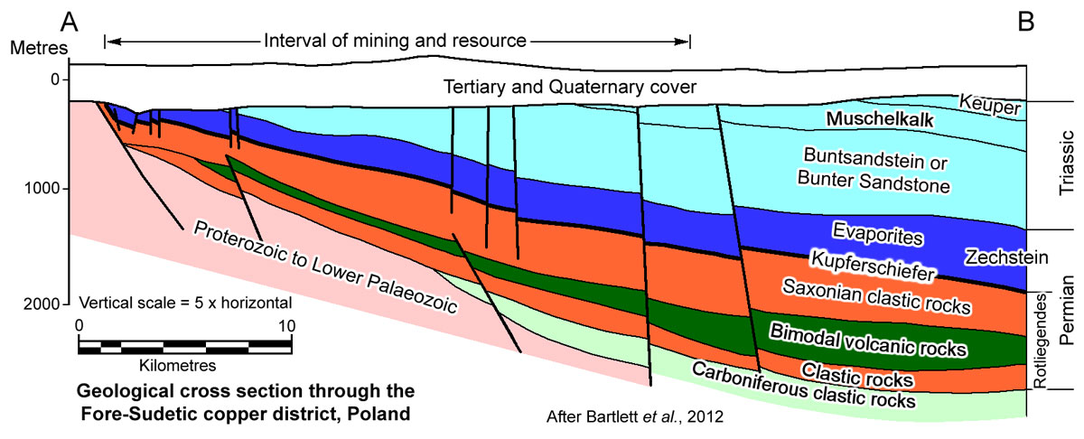
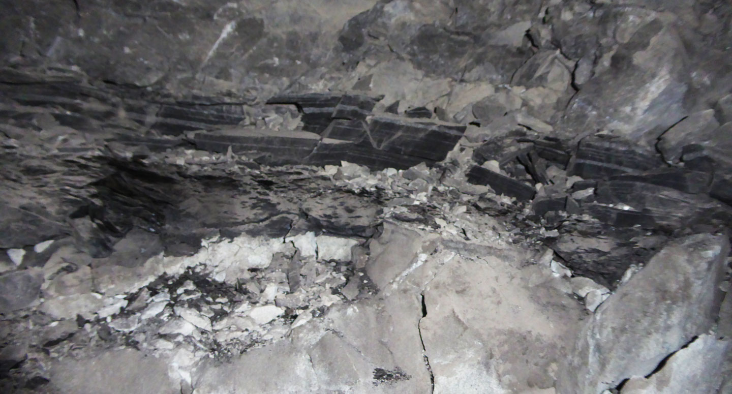 Kupferschiefer - fresh Kupferschiefer in a stope pillar underground at the KGHM Rudna Mine, Lubin District, Poland, occurring as a dark band averaging ~30 cm in thickness where photographed, sandwiched between the pale Weissliegendes sandstones below, and a pale grey dolostone above (this image is in colour). Note the shearing along the Kupferschiefer, particularly at the base. All three units were mineralised in this location. Photograph by Mike Porter, 2014.
* Zechstein Limestone, characterised by a highly variable thickness, ranging from a few metres, up to 120 m near shore, and 1 to 20 m in the basinal facies - consisting mainly of pre-evaporite limestone and dolostone, although it does contain some lenses of gypsum/anhydrite. It contains an average of 0.72% Total Organic Carbon (Kucha and Mayer, 2007). In the Fore-Sudetic Monocline deposits, it generally ranges from several metres in the western parts, to 40 m in the eastern down-dip sections. It comprises a lower unit that is basically a clayey dolostone, composed of argillaceous, silty and fossiliferous wackestones, but dominantly of biomicrite, overlain by a middle profile that is a dolostone, largely micritic with clay-rich laminae, and an upper calcareous dolostone unit composed of calcareous mudstones with interbeds that are oncolitic and bioclastic wackestones, packstones and grainstones as well as boundstones. Locally within this succession, there is up to 35% clay minerals and minor anhydrite, gypsum and quartz, both as clasts and authigenic accumulations (Oszczepalski, 1999; Borg et al., 2012). The basal section of the unit splits into sub-horizontal partings, typically 0.1 m to 0.7 m in thickness, immediately above the ore horizon (Bartlett et al., 2013)
* PZ-1 Evaporites - in the Fore-Sudetic Monocline, the Zechstein Limestone is overlain by 30 to 70 m thick Lower, or Werra Anhydrite, 0 to 150 m of halite, the "Oldest Halite" and the 20 to 70 m thick Upper Anhydrite.. In contrast, in the North Sudetic Trough, the same interval is occupied by ~70 m of red shale and sandstone, with anhydrite towards the centre of the basin (Oszczepalski et al., 1986).
PZ-2, Zechstein Cyclothem 2 - is composed of the basal Main Dolomite, a grey dolostone, overlain by the 15 to 51 m thick Basal Anhydrite. This cycle is absent in the North Sudetic Trough (Oszczepalski et al., 1986).
PZ-3, Zechstein Cyclothem 3 - is 2 to 56 m thick and composed of the basal Grey Pelite a grey dolostone, overlain by the Main Anhydrite. In the North Sudetic Trough, this interval is represented by 20 m of grey dolomite (Oszczepalski et al., 1986).
PZ-4, Zechstein Cyclothem 4 - is 13 to 47 m thick and composed of the basal Red Pelite a grey dolostone, overlain by the "Pegmatite Anhydrite" and the red shales of the "Top Terrigenous". In the North Sudetic Trough, this interval is represented by 20 m of dark red claystones (Oszczepalski et al., 1986).
Triassic, comprising up to 500 m of the Buntsandstein clastic rocks, and 200 m of the overlying Muschelkalk carbonate rocks in the North Sudetic Trough. In the mining area of the Fore-Sudetic Monocline, only the Lower Buntsandstein is preserved, as follows:
* Buntsandstein, which is ~140 to 300 m thick in the vicinity of the copper deposits, where only the lower part of the unit is preserved, but reaches >600 m where the complete unit is represented to the northeast. It is composed of a red to pink, fine- to medium-grained arkosic sandstone, that is cemented by argillaceous material, with intercalations of reddish-brown claystone that increase in frequency to the NW. The sandstone was initially deposited in a shallow-marine setting, later to become a periodically drying inland basin of low salinity, subject to fine clastic clayey and silty sedimentation, locally calcareous, with infrequent layers of oolitic limestones and/or silty limestones, sometimes with concentrations of rock salt and anhydrite, particularly towards the top of the sequence (Szyperko-Teller and Moryc, 1988). Within the North Sudetic Trough, where the total Buntsandstein is ~500 m thick, the lower sandstone unit is overlain by dolostones and red sandstones. Deposition of the Buntsandstein was related to a significant period of extension, which may have also contributed to the major salt doming event in the centre of the Polish Basin to the north (Kucha and Piestrzynski, 1995).
* Muschelkalk, that is found to the NE of the Fore-Sudetic Monocline copper deposit, where it was deposited in a shallow, epicontinental, open sea, dominated
by marine carbonate lithofacies, predominantly limestones and marls, which are ~200 m thick in the North Sudetic Trough (Oszczepalski et al., 1986).
* Keuper, during the early stages of Keuper deposition, only a shallow inland basin remained, in which deltaic-lagoonal-fluvial sediments were deposited.
Jurassic - during the Lower Jurassic, vast inland basin was filled by the Roethian epicontinental sediments, which on several occasions was affected by short-lived marine ingressions, to accumulate a sequence of variegated argillaceous sedimentary rocks, intercalated with conglomerates siltstones and dolostones in a variety of sedimentary conditions, from fresh-water, to brackish and marine environments. (Deczkowski and Franczyk, 1988).
Cretaceous, in the Fore-Sudetic area all the Jurassic and the part of Triassic deposits were eroded so the Upper Cretaceous sedimentary rocks transgressively overlie there the Buntsandstein or the Muschelkalk series. Only a few remnant of the Cretaceous sequence are preserved in the Fore-Sudetic Monocline, while in the North Sudetic Trough, ~360 m of fine sandstone and marl overlies the Triassic sequence (Oszczepalski et al., 1986; Karnkowski, 2007).
Tertiary, rocks range from 200 to 480 m in thickness, and comprise Oligocene sandy and silty sedimentary rocks; Miocene argillaceous, silty and sandy rocks with numerous brown coal seams; and Pliocene variegated clays. This package is up to 490 m thick in the Fore-Sudetic Monocline area, by considerably thinner in the North Sudetic Trough (Oszczepalski et al., 1986).
Quaternary, comprising 30 to 60 m of Pleistocene glacial sand gravel and clay and thin Holocene alluvium.
Significant 'Kupferschiefer' deposits in Poland and Germany appear to be localised where the reduced Zechstein carbonaceous shale-carbonate-evaporite sequence overlies the Rotliegendes sequence of oxidised clastic and bimodal volcanic rocks and overlaps the Devono-Carboniferous Variscan Orogen. They are also restricted to the irregular southern margin of the Southern Permian/Polish Basin where the underlying Rotliegendes was developed within a series of fault controlled elongate basins on the flanks of the Rhenish and Bohemian Massifs.
Structure
Carboniferous compressional structures are evident in the basement sequence related to the Variscan Orogeny. During the Permian and Mesozoic, the Fore-Sudetic area of Poland was mainly affected by high angle faulting, most of which trended NW-SE, north-south and east-west, and probably NNW-SSE. The latter are irregular, with individual structures varying from NNW to WNW, and are represented by small degrees of strike-slip low-angle dislocations, fractures developed in brittle sandstone, and folds in ductile shale. Displacements are normal, but vary in throw and horizontal movement. Strike-slip faulting, predominantly trending NE to NNE, is common, particularly within the Zechstein carbonate rocks, largely related to the Triassic to Jurassic Kummerian event, and to the early Tertiary stage of the Alpine Event which determined the current form of the Fore-Sudetic region. The main Polish deposits are situated in the southeastern part of the Fore-Sudetic Monocline, the middle part of the NW-SE Odra fault zone and adjacent to the Fore-Sudetic basement block (Oszczepalski et al., 1986; Borg et al., 2012).
Mineralisation
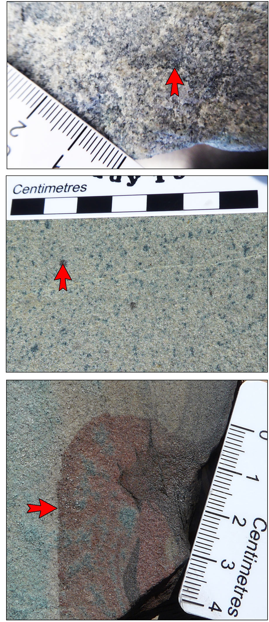 Kupferschiefer sandstone ore - the lower image shows a hematitic Rote Fäule patch within Weissliegendes sandstone (from historic core), in which microscopic studies indicate hematite is replacing earlier formed fine bornite and other sulphide minerals. The middle image illustrates ore within the Weissliegendes sandstones below the Kupferschiefer, from historic core stained by sulphide oxidation following exposure to the atmosphere. It contains 'flyspeck' disseminations and aggregates of bornite (the dark specks), one of which is indicated by the arrowhead. The upper image is of similar fresh sandstone hosted ore from the Rudna Mine, Lubin District. Photographs by Mike Porter, 2014.
While mineralisation outcrops to the south in the Konrad District of the North Sudetic Basin, it is everywhere blind in the Lubin area to the north of the Fore-Sudetic Block. The ore bearing units at Lubin dip gently at 2 to 3°NE, locally up to 5 to 6°, and are bounded to the south-west at a depth of around 400 m, by the major Odra Fault set that marks the north-eastern margin of the Fore-Sudetic Block.
In the Lubin District, mineralisation of greater than 0.1% Cu, but averaging 1 to 2%, covers an area of approximately 600 km2 between the main fault bounding the Fore-Sudetic Block to the south-west and the 1200 m depth contour. That contour is ~20 km to the NE of, and parallel to, the margin of the Fore-Sudetic Block. To a depth of 1600 m the same mineralisation covers an area of around 1100 km2.
Copper mineralisation is strata bound, occurring in three main ore types, reflecting host rocks and stratigraphic position. The principal copper minerals in all types of ore are chalcocite and digenite, which generally occur together in concentrations of up to 6 wt.%. Bornite (up to 3.5 wt.%), chalcopyrite (up to 1 wt.%), covellite (up to 1 wt.%) are also abundant, as are locally, minerals from the tetrahedrite group. Accessory minerals include tenorite, azurite, cuprite, native copper, enargite, galena, sphalerite, smithsonite, loellingite, arsenopyrite, cobaltite, nickeline, native silver and stromeyerite. The proportions of the various minerals vary with the ore type, stratigraphy and according to vertical and lateral zoning patterns. The three ore types are as follows:
i). Sandstone-ore - hosted by coarse clastic footwall sedimentary rocks of the Weissliegendes, and the Grauliegendes of the uppermost Rotliegendes. The mineral association varies across the field, with the predominant mineral assemblage in sandstone ore at the Lubin mine in the east and furthest from the Rote Fäule oxidation front, being bornite-chalcopyrite and bornite-chalcocite (Bartlett, et al., 2013). The most common non-copper sulphide is pyrite, while accessories include tetrahedrite. Pyrite and chalcopyrite, accompanied by minor bornite, prevail at the base of the mineralised horizon although the proportion of bornite increases upwards until it assumes the dominant role. Accompanying minerals in the upper part of the profile at Lubin include chalcopyrite, digenite and chalcocite. Further west, closer to the Rote Fäule oxidation front at Polkowice, Sieroszowice, Rudna and Deep Glogów, the main copper minerals in sandstone ore are chalcocite and digenite (Bartlett, et al., 2013).
These sulphides occur as fine anhedral and subhedral, 20 to 30 µm grains and aggregates occurring as disseminated interstitial pore fillings, clouds and clots, and as replacement of pre-existing carbonate and clay cements, diagenetic pyrite, fossil shells, feldspar within lithic clasts in the footwall conglomerates and sandstones, and sulphate and thiosulphate minerals, and occasionally as a sulphide rim to nodules with a carbonate shell and anhydrite core (Borg et al., 2012; Oszczepalski, 1989). Overall, chalcocite predominates, while bornite assumes local importance at Rudna. Where sighted underground during mine visits, the host sandstone was pale and friable.
Some of the best developments of copper mineralisation within the Weissliegendes (up to 26m thick), and highest grades (occurring as massive chalcocite and covellite), are immediately peripheral to the Anhydrite Zone, described above, where the capping Kupferschiefer is absent, and the sandstone is in contact with the overlying Zechstein carbonate and evaporite beds (Kucha and Pawlikowski, 1986). However, within the Anhydrite Zone the sandstones are usually barren with only minor pyrite, marcasite, galena, sphalerite and covellite (Borg et al., 2012.
The grade of the sandstone ore can range from 0.7% Cu in disseminated impregnation-type mineralisation, up to 30% Cu in massive replacement types of ore, but averages 1.8% Cu.
 ii). Shale-ore - hosted by Kupferschiefer sensu stricto black shale, which is characterised by abundant organic carbon. The mineralogy of shale ore is more complex than that of the sandstone-ore. The content of copper-bearing minerals commonly exceeds 4 wt.%, with chalcocite-bornite and bornite-chalcopyrite associations predominating, accompanied by pyrite, galena, sphalerite and marcasite. Accessories include tetrahedrite group minerals. There is a lateral zonation with bornite-chalcopyrite prevailing in the eastern section of the Lubin mining area and Malomice, bornite (-chalcopyrite) and minerals of the chalcocite group predominating in the vicinity of the main shafts at the Lubin mine, and chalcocite becoming the main copper mineral further northwestward. At Sieroszowice, digenite predominates and chalcocite is of secondary importance, while bornite and chalcopyrite are subordinate (Bartlett, et al., 2013).
Shale ore is enriched in silver minerals, particularly in the eastern and central parts of the Lubin mine, with grades that vary from 10 to >5500 g/t Ag, and occasionally to 10 kg/t. Silver is mainly found as isomorphic admixtures with bornite, chalcocite, djurleite, digenite and galena. It also occurs in the native metal, and forms its own minerals such as stromeyerite, cupriferous stromeyerite and jalpaite. These minerals are often found with calcite in veinlets and nests. Native silver also frequently replaces bornite, while stromeyerite commonly replaces chalcocite (Bartlett, et al., 2013).
Minerals of nickel and cobalt commonly occur with barite and gypsum in calcite veins. The most important nickel and cobalt bearing mineral is pyrite, while other nickel minerals associated with pyrite include rammelsbergite, tennantite, nickelite and gersdorffite. Cobalt minerals include smaltite and nickel-bearing cobaltite. The highest concentrations of Ni and Co are at the base of the Kupferschiefer in the eastern and central parts of the Lubin mine and in the Boundary Dolomite in the western part of the Lubin mine. The highest concentrations of molybdenum minerals (castaingite, molybdenite and jordisite) occur in the Boundary Dolomite near the western shafts at Lubin.
Au, Pd, Pt and associated Co, Mo, Ni, Bi and Hg, occur in significant quantities in the Rote Fäule Red Shale (oxidised Kupferschiefer) and the underlying Weissliegendes with hematite spots at the transitional zone between the sulphide and oxide facies in the Polkowice-Sieroszowice mine. They also occur, in smaller quantities, at the base of the Kupferschiefer, along a narrow north-south belt parallel to the band of organodendritic limestone in the western part of the Lubin mine (Bartlett, et al., 2013).
Within the Kupferschiefer, ore occurs in three main forms, namely: i) as fine, <5 µm disseminations, which comprises around 80% of the sulphides, typically concentrated in the organic-rich dark matrix, commonly occurring as fine bands; ii) coarser grained, >100 µm aggregates and lenses, commonly oriented parallel to shale laminae; and iii) thin veinlets of massive sulphide that are both concordant and transgressive to the laminae (Oszczepalski, 1989).
The abundant framboidal pyrite within the Kupferschiefer was formed during the earliest diagenesis as a precursor sulphide that has been replaced by later base metal sulphides. This pyrite has δ34S values from -3 to -44‰, but most commonly from -30 to -40‰, indicating a biogenic origin. The disseminated Cu, Pb and Zn sulphides in the same rocks have δ34S values from -2 to -44‰, with peaks values from -25 to -43‰ (Oszczepalski, 1989).
Where developed, the Boundary Dolomite at the transition from Weissliegendes to the Kupferschiefer carries grades that range from 1.1 to 12% Cu (Borg et al., 2012.
 Kupferschiefer shale ore - the lower section of the Kupferschiefer sensu stricto in the KGHM Rudna Mine, Lubin District. The lower contact is marked by the sharp colour change most evident to the right of the scale card. Note the mainly layer parallel veinlets, bands and disseminations of bornite, some of which are indicated by arrowheads. The rock also contains very finely disseminated grains of bornite not evident to the naked eye. The Kupferschiefer is a little thicker and less broken than on the image earlier in this record, but still has a brecciated and sheared lower contact zone of several centimetres thickness at the competency break. Photograph by Mike Porter, 2014.
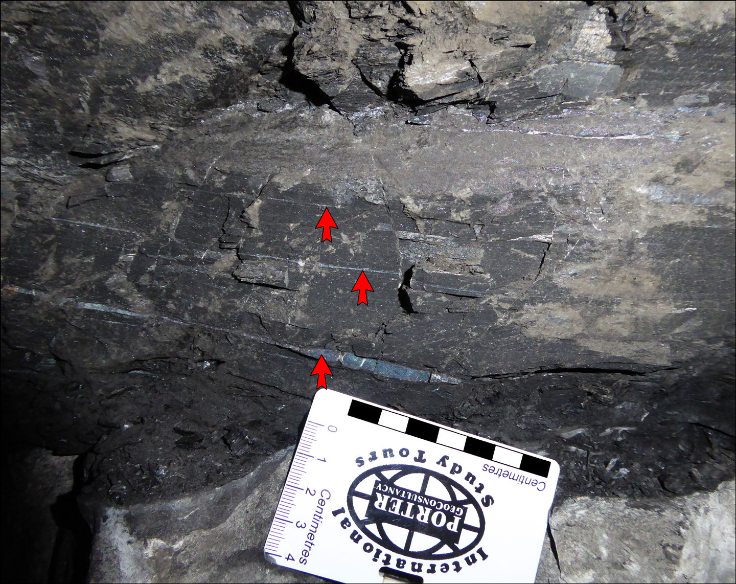
 Kupferschiefer shale ore hand specimen - from the KGHM Rudna Mine, Lubin District. Note the occurrence of chalcopyrite (cp), bornite (bn) and chalcocite (cc) which are both markedly transgressive ans well as following bedding partings. Note also the very fine vertical vein (vn) that appears to be displaced by bedding parallel and crosscutting mineralisation and contains sulphides that mimic those in the bedding parallel and transgressive ore layers. Photograph by Mike Porter, from sample collected in 1992.
iii). Carbonate ore - within hanging-wall marl and limestone, locally even extending into the overlying Werra Anhydrite. The most important copper mineral is chalcocite, which is commonly associated with digenite, bornite and covellite but rarely with chalcopyrite. Bornite is less abundant, but locally predominates over chalcocite. Chalcopyrite generally accompanies bornite but occasionally predominates, in which case bornite and other sulphide minerals occur as inclusions or intergrowths. Covellite tends to be associated with digenite and bornite. Accessory minerals include tetrahedrite, which occurs on its own or with bornite, and galena. Pyrite is abundant and predominates in some parts near the hanging wall of the carbonate ore horizon. Silver is contained in stromeyerite (Bartlett, et al., 2013).
Sulphides are found as very fine, irregular disseminations, spotted carbonate-replacement-style mineralisation, as nodules and as veinlets, although the highest grade zones have the least visible sulphides, being predominantly fine disseminations. The average grade within the hanging wall carbonate rocks is 0.7% Cu (Borg et al., 2012).
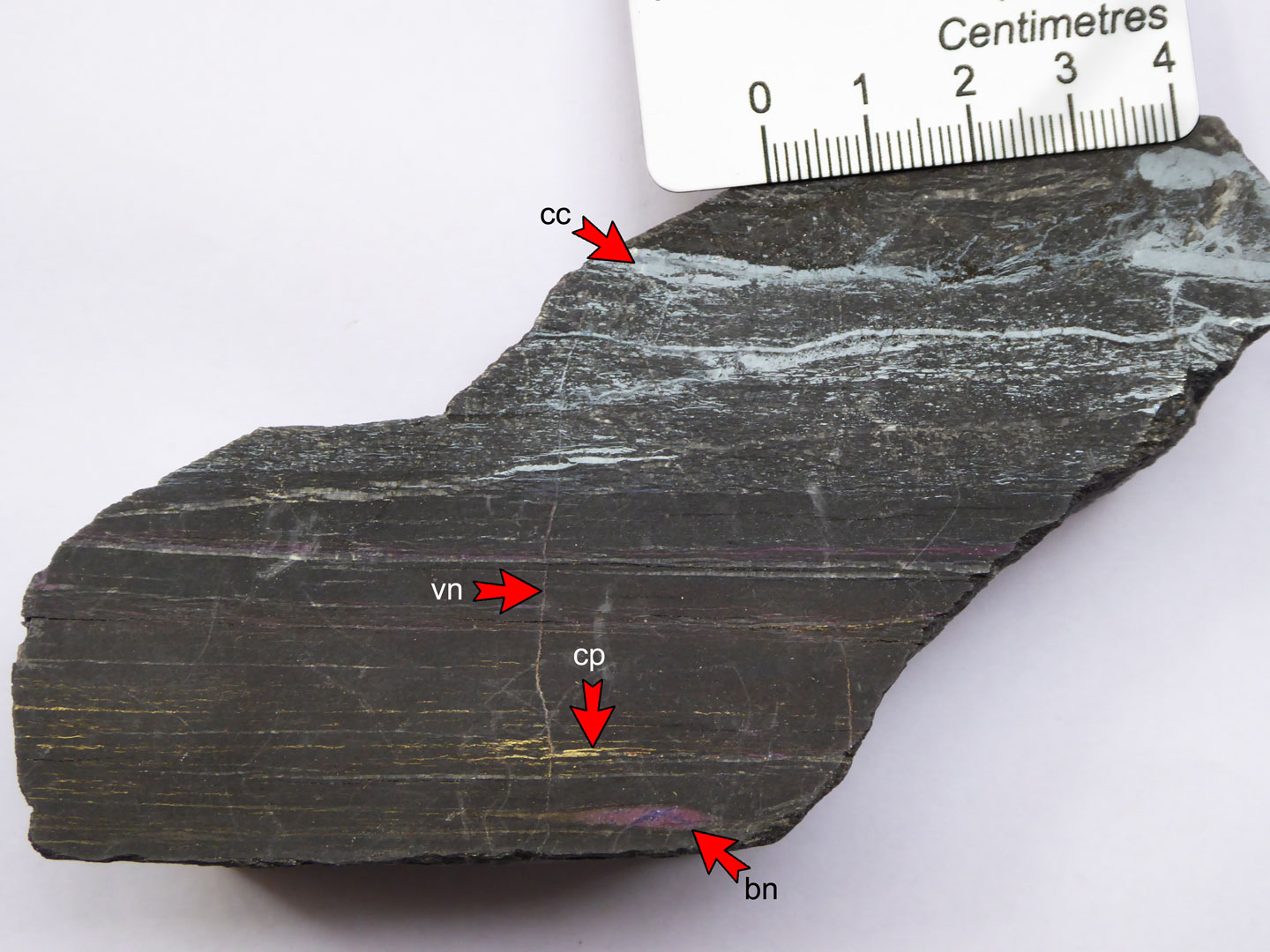
 Kupferschiefer carbonate ore - The right image is of poorly mineralised stylolitic and carbonate veined dolostone that occurs above the Kupferschiefer black shale/siltstone, while the left image is of the same carbonate rock, but more magnified, mineralised with disseminations of fine bornite, an example of which is indicated by the arrowhead. The apparent banding in this image is saw-cut striations. The arrow head is parallel to actual bedding and the elongation of sulphide blebs.. Photograph by Mike Porter, 2014.
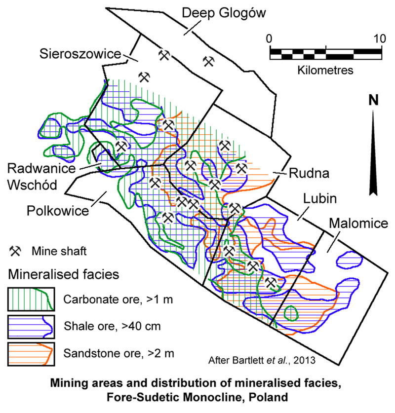
In the Fore-Sudetic Monocline deposits of Poland, sandstone-ore can be as much as 10 to 25 m thick, averaging 5.3 m at Rudna. Where the ore is exclusively within the Kupferschiefer it is generally only 50 to 60 cm thick, although room and pillar stopes 2 m high are mined and all extracted rock is passed through the mill for a head grade of around 1.8% Cu. Carbonate mineralisation within the Zechstein Limestone is more than 8 m thick over substantial areas.
Grades of >10% Cu are sometimes encountered in the Kupferschiefer, although within the sandstone and carbonate ores, Cu levels are usually <3%. Pb and Zn values are generally from 0.1 to 1% and around 0.1% respectively within the copper zone, although locally up to 20 m of 2 to 3% Pb have been encountered (mine visit, 1993). Overall, at least half of the ore is hosted by footwall sandstones and conglomerates and by hanging-wall carbonate rocks rather than by the Corganic-rich, originally pyritic black shale of the Kupferschiefer sensu stricto (Borg et al., 2012).
Regionally, variations in the importance of the three ore types are evident, with a high proportions of the ore in black shale in the Mansfeld/Sangerhausen district in Germany, where the principal host is the Kupferschiefer, and a higher percentage of sandstone and carbonate ores further to the east in the Spremberg/Weisswasser district of Germany (Kopp et al., 2008; Wedepohl and Rentzsch, 2006; Borg et al., 2012) and particularly in the Sieroszowice/Rudna mines in Poland. In addition, Rydzewski (1964) records well mineralised sections where the Kupferschiefer black shales are locally absent. The thickness of mineralisation, which varies gradually from Poland in the east to Germany in the west, is greatest within the Polish deposits.
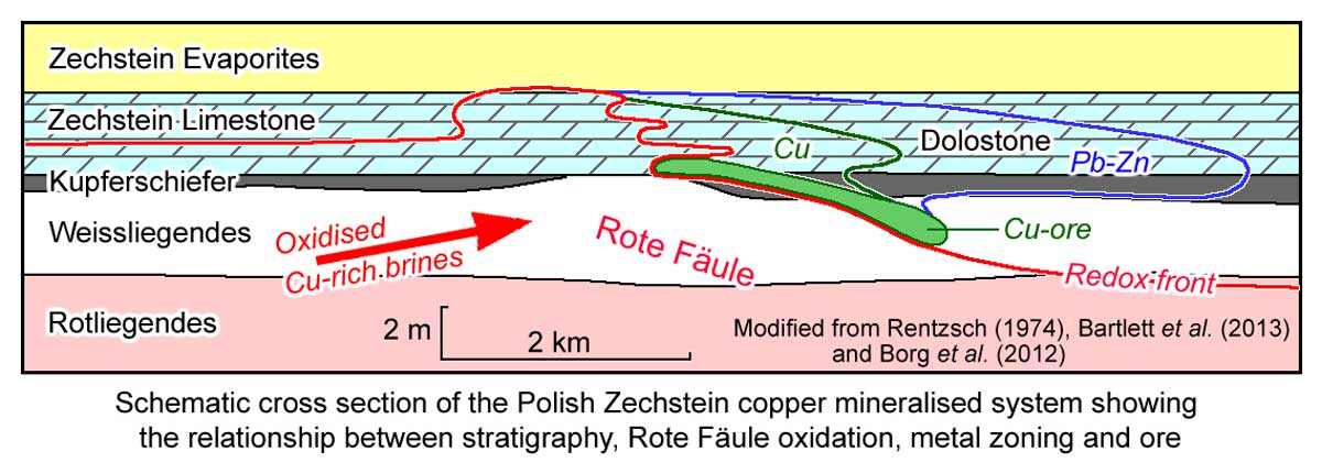 In the Fore-Sudetic Monocline area of Poland, the copper mineralisation is thickest, and has the highest grades, adjacent to the bounding fault of the Fore-Sudetic Block to the south-west, but decreases to the north-east. There is also a broad but systematic outward and upward metal and ore mineral zonation to the east, with a marked redox front at the proximal side. This zonal pattern transgresses stratigraphy at a shallow angle, and has generally produced lobe-shaped metal and redox zones. The various zones are (Borg et al., 2012 after Rentzsch and Knitzschke, 1968, Rentzsch 1974 and others):
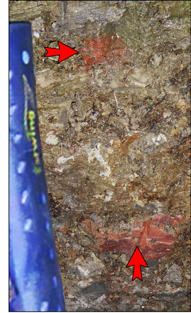
Rote Fäule - as seen in weathered outcrop, occurring as 'splotchy' hematite staining replacing iron and copper sulphides. This alteration style is located in oxidised sandstone and shale/siltstone below and lateral to ore. Photograph by Mike Porter, 2014.
i). a hematitic (Fe3+) footwall alteration zone, the Rote Fäule, which is characterised by 'splotchy' hematite staining that overprints all of the host units, destruction, leaching and oxidation of the carbonaceous sediments and pre-existing sulphides, leaving only refractory and immobile constituents. The oxidised rocks are marked by an abundance of ferric Fe-oxides, the presence of Au (max. 2.5 ppm) and PGE (max. 186 ppb Pt; 88 ppb Pd) in association with hematite at the transition from reduced to oxidised facies at the Rote Fäule front, high concentrations of aromatic hydrocarbons and asphaltenes, a high relative proportion of solid bitumen, the lowest δ13C and δ18O values in carbonates and the highest δ34S values in disseminated sulphides. A considerable loss of pyrite and base metals coincides with organic matter degradation (Oszczepalski, et al., 2002).
ii). a copper zone with ore minerals ranging from chalcocite to bornite to chalcopyrite. The highest Cu grades are closest to the Rote Fäule front.
iii). a widely overlapping, weakly mineralised lead-zinc zone with lead being more proximal and zinc more distal; and
iv). an (Fe2+) zone that is barren and contains only diagenetic, framboidal pyrite. This outer pyrite is interpreted to represent an original, early diagenetic, pre-mineralisation component, as it is present regionally throughout much of the Kupferschiefer (see the Kupferschiefer description in the Geology section above) and is replaced by copper minerals.
The redox front-related mineralising system is interpreted to be due to ascending metalliferous brines which have interacted with early diagenetic pyrite in a systematic, dynamic, step-wise replacement process that caused the wide metal and ore mineral zonation pattern, which can be represented by the following general order of gradual replacement: early diagenetic, pre-ore pyrite and authigenic anhydrite → sphalerite>galena → galena>sphalerite → chalcopyrite/bornite → chalcocite → hematite of the Rote Fäule redox front (Borg et al., 2012 and others). These brines are generally accepted to have been oxidising (in the hematite stability field), weakly acidic, Na-Ca-Cl basinal brines (Oszczepalski, et al., 2002), originating within the underlying Rotliegendes red beds by convection (Jowett, 1986; Oszczepalski, 1989), salt doming (Kucha and Pawlikowski, 1986) or direct expulsion (Cathles et al., 1993)
Within the Lubin district, this zonation is manifested by the dominant host to the west in the Sieroszowice mine being the Kupferschiefer and overlying Zechstein Limestone, immediately above and adjacent to the Rote Fäule where it cuts those units. Further to the east, at the Rudna and Lubin mines, as the upper margin of the Rote Fäule dips more steeply to the north-east than the host lithologies, the main copper mineralisation is found progressively lower within the sequence, mainly in the Kupferschiefer and the Weissliegendes sandstones.
Where the Kupferschiefer is missing the ore may extend locally into the Lower Anhydrite. The Rote Fäule forms a sharp margin to ore in the west, while to the east, north-east and north there is gradual drop-off in grade through low grade ore to geochemical levels.
The laterally and vertically zoned mineralisation front mostly shows a shallow oblique upward migration direction, although, locally inverse zoning is evident (Kulick et al., 1984; Schmidt, 1987), e.g., in the sandstone ore at Lubin, interpreted to represent a permeability controlled "roll over" effect of the migrating fluids, possibly controlled by a permeability influenced variation in the vertical and lateral flow of brines (Schmidt, 1987).
Locally, a narrow precious metal-rich zone straddles the redox front, with the highest grades of gold and PGEs located very close to the redox boundary. The precious metals can occur locally in Cu-rich strata on the chemically reducing side (e.g., Walther et al., 2009) or on the immediately adjacent oxidised side of the redox front (e.g., Piestrzy'nski et al., 2002).
The zoned strata-bound to gently crosscutting mineralisation described above has locally, in turn, been overprinted by even later, vein-type mineralisation, e.g., in the German Spessart and Rhön areas (Friedrich et al., 1984). Here, the subsequent mineralisation is rich in As, Co and Ni. Rich vein-type mineralisation has also been described from several Polish deposits (Oszczepalski, 1999).
Zechstein formations cover 57% of Poland, although 'industrial' Cu deposits only occupy 0.5% of the area of the Zechstein, and are only known in the south-west of the country. A number of Rote Fäule areas are recognised within the sequence, covering a total cumulative area of 6000 sq. km, or 4% of the Zechstein.
Age of Mineralisation
As detailed above, the host Kupferschiefer of the Lower Zechstein sequence, it is generally accepted to have been deposited at ~255 Ma (Borg et al., 2012 and sources cited therein).
Symons et al. (2010) conducted detailed Palaeomagnetic age dating of the Kupferschiefer mineralisation in the Sangerhausen district in Germany, which is more precise than the earlier Mid-Triassic palaeomagnetic dating of the Rote Fäule in Poland by Jowett et al. (1987). This more recent work, based on 205 samples from 15 underground sites, gave a Late Jurassic palaeopole of 149±3 Ma on the apparent polar wander path for Europe of Besse and Courtillot (2002), but also a secondary palaeopole at 53±3 Ma.
Deposit Geology
The geology of each of the main deposits is as follows (information largely from Bartlett et al., 2013):
Lubin-Malomice
Mineralisation in these adjacent blocks, exploited by the Lubin mine, is distributed overs an area of 70 km2 at depths of between 635 and 1000 m below surface. The full host sequence typically comprises the following, from the base:
• Weissliegendes sandstones, 8 to 10 m thick, occurring as fine-grained white sandstone with calcareous cement, passing downwards into clay cement. The uppermost 2 to 3 m may be mineralised. Where present, the base of this copper mineralisation is sometimes marked by the so-called "bornite smear", which can attain grades of 3 to 4% Cu over a thickness of as much as 10 to 20 cm. Elsewhere, a second mineralised band is locally encountered in the Weissliegendes, generally separated from the Kupferschiefer by 2 to 3 m of sandstone with only traces of copper sulphides. This latter mineralisation is not usually of economic importance because of its limited lateral extent and patchy nature, except where copper mineralisation extends upwards through the whole interval to the Kupferschiefer.
• Boundary Dolomite, ~5 cm thick, made up of grey micritic dolomite.
• Kupferschiefer, of variable, thickness, generally 30 to 50 cm of mineralised shale that is bituminous in the lower, and dolomitic in the upper part, with a variably transitional to sharp upper interface.
• Clayey Dolostone.
• Streaky Dolostone, generally well banded.
• Calcareous Dolostone.
Two contrasting structural domains are recognised within the combined Lubin-Malomice mining area. The southern part of the area, is dislocated by a series of WNW striking faults with throws ranging from 10 to 100 m, leading to local steepening of the sequence to 10 to 15°, sometimes to as much as 40°, and even local reversals of dip. In contrast, the northern part of the mining area is little disturbed by faulting, with generally constant dips, typically of 2 to 6°NE.
In 2012, sandstone ore constituted 64.5% of the reserves of the mine and produced ~76% of the mine output. This ore typically contains 0.7 to 5.5% Cu. Shale and carbonate ore is absent over large areas in the central and southeastern parts of the Lubin-Malomice mining area, but occurs without the underlying sandstone ore, in the southwestern part of the Lubin mine. The copper content in shale-carbonate ore ranges from 0.7 to 16% Cu. The Kupferschiefer contains the highest copper grades, which gradually decrease in both the hanging wall and footwall of this unit. Overall, horizontal grade variations are insignificant. The ore thickness generally varies from 1 m to 7 m but, locally, exceeds 17 m. In both Lubin and Malomice, the average ore thickness is ~3 m. In broad terms, there is a NW-trending zone of relatively thick ore (i.e., >4.5 m) running between the central and western shafts. Another thick zone occurs to the northeast of the eastern shafts, straddling the boundary between the Lubin and Malomice mining areas, where the ore is up to 9 m in thickness, although mineralisation is unusual, occurring in a basin-like depression within the Weissliegendes, 3 to 9 m below the top of the unit, with no overlying shale, but instead reef, algal and sandy dolostones.
Polkowice and Sieroszowice
In the Polkowice mining area, copper mineralisation covers an area of 22.2 km2 at depths of between 381 and 893 m below surface. Within the contiguous Sieroszowice area, immediately to the north, mineralisation extends over an area of 59.6 km2, at depths of >657 m below surface.
There are significant variations in the development of the Zechstein within these mining areas. In the western and southwestern part of the Polkowice mining area, the lowermost Zechstein is occupied by the oxidised, Rote Fäule (Red Spotted) facies, characterised by red hematite-bearing alteration of the Kupferschiefer, and red patches and spots imposed on the underlying Weissliegendes. Copper sulphides and silver mineralisation are absent within this oxidised facies, although gold and platinoids are found instead, dominanty at the transitional zone between the oxidised and sulphide facies. The Rote Fäule passes laterally (north and northeastward) into the Kupferschiefer, which is overlain by sulphide-bearing dolostone. The underlying Weissliegendes is barren, except near the boundary with the Lubin mining area to the east, and in the northern and northwestern parts of Sieroszowice.
The Polkowice mining area is divided into two structural domains by the Biedrzychowa Fault, an ENE striking scissor fault in the northern part of the mining area. This structure has a throw of up to 50 m, and associated short NE-trending splay faults. The interval to the NW and north of this fault, including the Rote Fäule, has a simple monoclinal structure with a gentle dip to the NE. In contrast, the sequence to the southeast and east of the fault is cut by south-dipping reverse faults with vertical displacement components of 50 to 100 m. The southern margin of this structural domain is marked by a pre-Tertiary outcrop. Reverse faulting declines to the NE, eventually assuming reasonably uniform monoclinal characteristics. There are relatively few faults in the Sieroszowice mining area, and where developed, have throws ranging from 0.5 to several metres, with some being flexures rather than faults. The monoclinal structure is gently folded into west-east trending open folds, interpreted to be due to the damping effect of the salt horizon that occurs some 15 to 25 m above the Kupferschiefer.
Shale-carbonate ore predominates in Polkowice and in the developed parts of Sieroszowice, where it is generally from 0.6 to 4.5 m thick, thinning southwards. Over much of the central part of the Sieroszowice area, the ore thickness is only 1 to 1.5 m, with low grade and barren intercalations.
Sandstone ore is found in the eastern and northeastern part of the Polkowice area where it adjoins the Lubin mine, and in the northeastern part of the Sieroszowice area.
Radwanice Wschód
Copper mineralisation covers an area of 12.8 km2 in the central-eastern part of the small Radwanice Wschód (east) area, which is accessed and mined from the Polkowice-Sieroszowice mine. Copper mineralisation exceeding the cut-off grade is hosted by the Kupferschiefer and carbonates of the basal Zechstein only, with grades in the underlying Weissliegendes being <0.4% Cu. The depth to the footwall varies from 503 to 691 m below surface. The ore varies from 1.1 to 4.2 m, averaging 2.89 m. Because of the proximity to the Rote Fäule oxidation front to the west, the copper grade changes rapidly, both horizontally and vertically. The highest grades (maximum 13.1% Cu) are in the Kupferschiefer. Tertiary sands and clays form the hanging wall in the southeastern part of the resource area. Elsewhere, the hanging wall comprises limestones and dolomites covered with Zechstein anhydrite.
Rudna
In the Rudna mining area, copper mineralisation covers an area of 40.0 km2. The distribution of the various lithological ore-types is controlled by the relief of the upper surface of the Weissliegendes. From south to north, the main features are:
• Southern Rudna Elevation, 900 m below the surface, occurring as a 1 x 1 km domal structure.
• Central Rudna Elevation, 950 to 1000 m below the surface, forming a 300 to 1000 m wide, WNW elongated ridge, the flanks of which slope at 10° SE and NW.
• Northern Rudna Elevation on the 1050 m level, a WNW elongated ridge with dimensions similar to the Central Rudna Elevation.
• Tarnówek Elevation, which is ~800 m wide and occurs on the 1100 m level.
• Zelazny Most Elevation, which occurs at depth on the northern margin of the Rudna mining area.
These elevations appear to represent ridges, interpreted to be sand dunes (Jowett, 1991), separating broad, flat, pre-Zechstein valleys, and cause the Kupferschiefer to wedge-out on their flanks. The sequence in the flat depositional depressions/valleys, typically comprises all of the key lithological units, i.e., the Weissliegendes is progressively overlain by the Boundary Dolomite, Kupferschiefer and Basal Dolostone. However, profiles over the elevations, commonly commence with Weissliegendes facies containing irregular patches of anhydrite cement, and is overlain directly by the Basal Dolostone unit, comprising basal patches of algal and organogenic dolostone, locally covered by sandy dolostone, and then overlain by units such as the Streaky Dolomite, similar to the sequence above the depositional depressions/valleys.
The Fore-Sudetic Monocline is modified within the Rudna mining area by two ENE-trending structures. The first of these is the Biedrzychowa Fault system, that extends eastward from the Polkowice area (described above), cutting the southwestern part of the mining area, with throws of 40 to 140 m to the NW. To the north, the 200 m wide, WNW-striking Main Rudna Fault, with a throw up to 30 m to the north, abuts the Biedrzychowa Fault. The second main structure, the Paulinowa Syncline, is to the west of the western shaft, and forms a 20 to 30 m deep trough that parallels the Biedrzychowa Fault.
The characteristics and distribution of copper mineralisation are influenced by the facies differences between the flats and elevations. The main ore zone in the south of the mining area follows a broad flat valley that extends into the adjacent Polkowice and Lubin areas. Mineralisation persists from the upper sections of the Weissliegendes (0.8 to 4 m), through the Kupferschiefer (0.4 m), Clayey Dolostone (0.1 to 0.6 m) and Streaky Dolostone (1.2 to 3 m), into the bottom part of the Calcareous Dolostone, for an overall mineralised thickness that varies from 2 to 6.5 m, averaging 4.5 m. The sections in the other valleys are comparable, e.g., the mineralised thickness in the valley between the Central and the Northern Rudna elevations varies from 2 to 7 m, while the flat separating the Northern Rudna and the Tarnówek elevations is <6 m thick.
In contrast, over the Weissliegendes ridges, where the Kupferschiefer is absent, copper mineralisation is restricted to the Weissliegendes itself, and the Calcareous Dolostone only, with mineralised thicknesses generally >7 m and locally >20 m. The extent of ore development within the Weissliegendes is directly related to the type of cement now within the host rocks. Where the crestal sections of ridges contain irregular patches of sandstone cemented by anhydrite or a mixture of anhydrite and clay as is typically the case, the sandstone is barren. When the preserved anhydrite cemented sections of the sandstone are patchy and thin, copper mineralisation may continue uninterrupted beneath, but when anhydrite cement persists to greater depths, copper will not occur at all. Jowett (1991) interprets the inverse relationship between anhydrite and sulphides to reflect the degree of mineralisation, whereby the mineralising process consumes sulphur from anhydrite to form sulphides and a gangue of carbonate cement.
Overall, sandstone ore constitutes the dominant proportion of the ore reserve at Rudna.
Deep Glogów
The Deep Glogów area comprises a NW-SE trending strip, bordered to the SW by the Sieroszowice and Rudna mines, and is underlain by copper mineralisation which covers an area of 56 km2, representing the continuation of the deposit within these adjacent mining areas. The deposit is mined from the Rudna mine (50%) and the Polkowice-Sieroszowice mine (50%), and not as a separate operation. The depth to the top of the orebody varies from 1200 to 1400 m below surface, and has a thickness that ranges from 0.74 to 4.13 m, averaging 2.11 m, with a varying grades and host lithologies. The thinnest sections of the deposit are in the western and central parts of the mining area (i.e., north of the Sieroszowice mining area), where the ore is hosted by the Kupferschiefer and in the upper Weissliegendes, and locally in the east, to the north of the Rudna mining area. Carbonate ore is also present in other parts of the mining area. The shale ore has thicknesses of from 0.02 to 0.81 m and accounts for 13% of the ore, while the carbonate ore has an average thickness of 0.49 m, for 27% of the ore, and the dominant sandstone ore, with thicknesses of from 1.15 to 3.59 m, contains 60% of the orebody.
The mineralisation mainly occurs as fine grains of sulphides, mostly distributed evenly, but sometimes concentrated in the form of smudges and extended pockets. Locally, coarse-grained mineralisation is found in veins of varying thicknesses or irregularly distributed pockets. All of the ore types found in the Deep Glogów deposit are dominated by chalcocite and digenite. Accompanying elements include lead, silver, cobalt, zinc and nickel.
Formation of Ore
The formation of the ore deposits of the Kupferschiefer have, in the past, been attributed to a range of processes, including syngenetic (e.g., Freiesleben, 1815 to Sawłowicz, 1990), epigenetic (e.g., Beyschlag, 1900 to Wyzykowski 1971) and early diagenetic (e.g., Rentzsch,1964 and Oszczepalski 1989) metallogenic models. Jowett (1986), Hammer et al. (1990) and Oszczepalski and Rydzewski (1991) proposed a late diagenetic formation by large-scale convective flow during Triassic rifting. Multi-stage models were suggested by Beyschlag (1900, 1921), Vaughan et al. (1989), Rentzsch and Friedrich (2003), Wodzicki and Piestrzy'nski (1994) and Piestrzy'nski et al. (2002).
The transgressive to crosscutting nature at both the deposit and regional scale metal and ore mineral zonation pattern, hosted by rocks from the Weissliegendes to Zechstein evaporites, combined with the spatial relationship to fault structures, ubiquitous textures of ore minerals replacing pre-existing early diagenetic pyrite, local carbonate/sulphate cements, fossil shells and lithic clasts, and mass-balance considerations (e.g., the insufficiency of biogenic sulphur from the black shale to produce the total Cu sulphide ores) all suggest the epigenetic origin of the economic Kupferschiefer orebodies.
The main features of the interpreted development of these deposits may be summarised as follows (after Borg et al., 2012):
The fault-bounded continental Rotliegendes basin was rapidly filled with immature red clastic sedimentary, evaporitic and bimodal volcanic rocks. Erosion of the bimodal volcanic rocks were a major source of detritus for the clastic rocks of the oxidised Rotliegendes sedimentary pile. Basinal fluids were moderately warm, oxidising, saline and capable of altering all rock types of the basin fill and of basement rocks in permeable faults and shear zones.
The rapid transgression by the enclosed, relatively stagnant, Kupferschiefer Sea, subsequently resulted in a euxinic body of water and shallow swamps, which infiltrated the topmost red beds in a descending and irregular fashion thus creating the bleached and chemically reduced Grauliegendes.
Deposition of Corganic-rich mud that produced the Kupferschiefer sensu stricto at ~255 Ma, acted as a chemical sink for the precipitation of framboidal pyrite and minor accumulations of base metals. During sedimentation and early diagenesis, bacterial sulphate reduction (BSR) will produce H2S, which reacts with simultaneously generated Fe2+ to precipitate iron monosulphides, subsequently transformed to framboidal pyrite by reaction with the excess of H2S, at a temperature of >60°C (Butler and Rickard, 2000)
Sediment compaction caused partial basin dewatering and mobilisation of metalliferous brines from deeper parts of the basin. These fluids possibly partially oxidised rocks of the Grauliegendes, Weissliegendes, Kupferschiefer sensu stricto and Zechstein, although, this process was increasingly hindered by low primary permeability and the increasing occlusion of porosity by diagenetic cementation of the clastic sedimentary basin fill and was therefore probably not responsible for the major pulse of mineralisation.
The major late Jurassic central European transpressive tectonic event at ~150 Ma, involved some regional crustal tilting and the development, or reactivation of major NW-SE and NNE-SSW trending fault systems. These structures dissected both basement rocks (particularly the deformed Variscan magmatic arc rocks) and the basinal volcanic and volcano-sedimentary succession, which had acted as a reservoir for the moderately heated and metal-charged fluids that had accumulated over the previous ~100 m.y.
Reactivation of these structures allowed the mobilisation and transport of fluids over large vertical and lateral distances, spreading slowly laterally in the uppermost Rotliegendes and Weissliegendes clastic rocks to suitable, structurally controlled trap sites.
These brines were oxidising (in the hematite stability field), weakly acidic, Na-Ca-Cl basinal brines (Oszczepalski, et al., 2002). They oxidised the rocks transited, accompanied by the dissolution of pyrite and other metal sulphides, leaving a residue of hematite to form much of the Rote Fäule. This dissolution resulted in a (sulphur? and) metal-rich solution at the Rote Fäule redox front.
The thin, shallowly dipping Kupferschiefer black shale acted as a hydrodynamic and geochemical barrier that slowed or stopped ascending fluid flow, and resulted in the ponding of the metalliferous brines below the black shale aquitard. These mineralising fluids had a long residence and reaction time within the uppermost, partially sulphate-cemented coarse clastic sedimentary rocks of the Rotliegendes and Weissliegendes/Grauliegendes and the more impermeable but also more reactive Corganic-rich, pyritic Kupferschiefer black shale.
The sulphate cement, particularly evident where the Weissliegendes dunes 'penetrate' the Kupferschiefer and provide a fluid flow connection to the overlying Zechstein evaporites, (c.f., the Anhydrite Zone described above) were most likely the result of diagenetic brine reflux, whereby dense Mg-Ca-SO4 brines, sourced from those Zechstein evaporites, sank to displace lighter fresh pore waters and precipitated anhydrite within the coarse clastic rocks, prior to the mineralising event.
In addition to the early diagenetic/bacteriogenic pyrite of the Kupferschiefer (e.g., Wodzicki and Piestrzy'nski, 1994; Oszczepalski, 1999) and the diagenetic anhydrite cement of the Weissliegendes, other potential sulphur sources include organic sulphur and H2S from natural gas (Jowett, 1992; Oszczepalski, 1999). Natural gas reservoirs in Poland and across Europe to the North Sea are within the Rotliegendes and Zechstein carbonates of the Southern Permian Basin, capped by the Kupferschiefer and Zechstein evaporites, and in associated with Zechstein salt domes in central Poland (e.g., Jowett, 1992).
The utilisation of sulphate to provide the additional sulphur required for precipitation of large amounts of base metal sulphides, may have originated from thermochemical sulphate reduction (TSR), which is possible at temperatures of >80 to 100°C (e.g., Machel et al., 1995) in the presence of hydrocarbons, derived from either natural gas, or the organic component of the Kupferschiefer (Jowett, 1992). During TSR, fractions from the organic matter/hydrocarbons are partially oxidised to produce (sparry) dolomite and/or calcite and the remaining organic matter/hydrocarbons are converted to solid bitumen (pyrobitumen), with the production of H2S, which is isotopically heavier compared to that generated by BSR (as is observed), as follows - CaSO4 + CH4 → CaCO3 + H2S + H2O. When this H2S reacts with Cu-bearing chloride brines, copper sulphide (initially chalcopyrite) is formed - H2S + 2 CuCl → Cu2S + 2 HCl. However, this reaction also produces HCl, which can reverse the reaction (Anderson and Garvin, 1987), unless excess additional metals (particularly Mg and Fe) are present in the brine to neutralise the acid and produce dolomite and siderite, rather than calcite - CaCO3 + (Mg/Fe/Mn) + HCl → CaCl + (Mg/Fe/Mn)CO3 + H2O (Orr 1974; Irwin, et al., 1977). The carbon isotope composition of the diagenetic saddle dolomite is lighter than that of sedimentary carbonates, as is observed (Borg et al., 2012). With the addition of further Cu in solution, in the absence of additional sulphur, chalcopyrite has been experimentally shown to sequentially be replaced by bornite (Cu5FeS4), covellite (CuS), chalcocite (Cu2S) and native Cu (Zies et al., 1916).
The sulphate cements within the Weissliegendes/Grauliegendes were slowly consumed by the formation of sulphides and carbonate gangue through reaction with the mineralising brines. The permeability was thus increased, and the dunes penetrating the Kupferschiefer, as well as fault and shear zones, acted as slow hydrodynamic valves through the black shale aquitard, releasing the largely depleted metal-bearing brines into overlying, reactive carbonate and evaporite rocks of the hanging wall to form the carbonate ores. This slow escape also promoted fluid flow and allowed ingress of additional metalliferous brines from below. Borg et al. (2012) regard this low fluid velocity as probably the main reason for the development of the particularly pronounced and extensive metal and mineral zonation pattern of the mineralised system. They also suggest that most of the economic copper orebodies were formed during this late Jurassic metallogenic stage. Jowett (1986; 1992) argued the brines were part of a large scale convective cell that rose through the fault system, but did not escape upwards, past the Kupferschiefer, instead moving laterally along the base of the aquitard to the centre of the basin to sink, dissolve more metal from the presumed source Rotliegendes pile and rise again. This mechanism reduces the limitation on the volume of available brines required and may have been driven by heat from a mantle underplate emplaced during the preceding Triassic rifting and perpetuated by the continued Jurassic transpression.
A later metallogenic pulse occurred at ~53 Ma, during the Tertiary, when subcontinental-scale tectonic structures underwent another phase of reactivation and hot-spot magmatic activity provided additional sources of metals and local heat. This stage is responsible for localised high-grade, massive vein- and breccia-type ores that have overprinted earlier types of ores in many of the Kupferschiefer mining districts (Borg et al., 2012).
Reserves and Resources
Published reserve and resource figures, include:
Pre-mining (1963) reserve + inferred resources to 1250 m depth in the 175 km2 of the Lubin, Rudna, Sieroszowice and Polkowice mines
2.70 Gt @ 1.92% Cu, 52 g/t Ag, containing 52 Mt Cu, 141 000 t Ag (Borg et al., 2012)
Total reserves (categories B + C1) at 31 December, 2011 (Bartlett et al., 2013, for KGHM Polska Miedź S.A.) were:
Lubin-Malomice - 387.52 Mt @ 1.33% Cu, 55.6 g/t Ag for 5.13 Mt Cu, 21 527 t Ag;
Polkowice - 114.03 Mt @ 2.34% Cu, 47.9 g/t Ag for 2.67 Mt Cu, 5465 t Ag;
Sieroszowice - 297.61 Mt @ 2.61% Cu, 64.9 g/t Ag for 7.77 Mt Cu, 19 303 t Ag;
Radwanice Wschód - 6.48 Mt @ 2.01% Cu, 28.1 g/t Ag for 0.13 Mt Cu, 183 t Ag;
Rudna - 397.62 Mt @ 1.70% Cu, 47.3 g/t Ag for 6.76 Mt Cu, 18 799 t Ag;
Deep Glogów - 291.59 Mt @ 2.40% Cu, 78.7 g/t Ag for 7.00 Mt Cu, 22 939 t Ag;
TOTAL - 1.49485 Gt @ 1.97% Cu, 59.0 g/t Ag for 29.45 Mt Cu, 88 216 t Ag.
Adjacent additional inferred mineral resources (Borg et al., 2012)
212.5 Mt @ 1.88% Cu for 3.99 Mt Cu.
In addition to the references listed below, information has been taken from: Bartlett S C, Burgess H, Damjanović B, Gowans R M and Lattanzi C R, 2013, Technical report on the copper-silver production operations of KGHM Polska Miedź S.A. in the Legnica-Glogów copper belt area of Southwestern Poland; Report prepared for KGHM Polska Miedź S.A., by Micon International Limited, 170p.
The most recent source geological information used to prepare this decription was dated: 2012.
Record last updated: 4/12/2013
This description is a summary from published sources, the chief of which are listed below.
© Copyright Porter GeoConsultancy Pty Ltd. Unauthorised copying, reproduction, storage or dissemination prohibited.
|
|
|
|
|
Bechtel A, Elliott W C, Oszczepalski S 1996 - Indirect age determination of Kupferschiefer-type mineralization in the Polish Basin by K/Ar dating of illite: preliminary results: in Econ. Geol. v91 pp 1310-1319
|
Bechtel A, Elliott W C, Wampler J M, Oszczepalski 1999 - Clay mineralogy, crystallinity, and K-Ar ages of Illites within the Polish Zechstein Basin: Implications for the age of Kuperschiefer mineralization: in Econ. Geol. v94 pp 261-272
|
Blundell D J, Karnkowski P H, Alderton D H M, Oszczepalski S, Kucha H 2003 - Copper Mineralization of the Polish Kupferschiefer: A Proposed Basement Fault-Fracture System of Fluid Flow: in Econ. Geol. v98 pp 1487-1495
|
Borg G, Piestrzynski A, Bachmann G H, Puttmann W, Walther S and Fiedler M 2012 - An Overview of the European Kupferschiefer Deposits: in Hedenquist J W, Harris M and Camus F, 2012 Geology and Genesis of Major Copper Deposits and Districts of the World - A tribute to Richard H Sillitoe, Society of Economic Geologists, Denver, Special Publication 16, pp. 455-486
|
Cathles L M, Oszczepalski S, Jowett E C 1993 - Mass balance evaluation of the late diagenetic hypothesis for Kupferschiefer Cu mineralization in the Lubin Basin of southwestern Poland: in Econ. Geol. v88 pp 948-956
|
Haynes D W 1986 - Stratiform Copper deposits hosted by low-energy sediments: I. Timing of Sulfide precipitation - an hypothesis: in Econ. Geol. v81 pp 250-265
|
Haynes D W 1986 - Stratiform Copper deposits hosted by low-energy sediments: II. Nature of source rocks and composition of metal-transporting water: in Econ. Geol. v81 pp 266-280
|
Hitzman M W, Kirkham R, Broughton D, Thorson J and Selley D, 2005 - The sediment-hosted stratiform copper ore system: in Hedenquist J W, Thompson J F H, Goldfarb R J and Richards J P (Eds.), 2005 Economic Geology 100th Anniversary Volume, Society of Economic Geologists, Denver, pp. 609-642
|
Hitzman, M.W., Selley, D. and Bull, S., 2010 - Formation of Sedimentary Rock-Hosted Stratiform Copper Deposits through Earth History : in Econ. Geol. v.105, pp. 627-639.
|
Jasinski A J, 1994 - The formation of copper-bismuth sulphosalts in sedimentary copper deposits: The Fore-Sudetic Copper Deposit, Poland as an example: in Ore Geology Reviews v9 pp 209-217
|
Jowett E C 1986 - Genesis of Kupferschiefer Cu-Ag Deposits by Convective flow of Rotliegende brines during Triassic rifting: in Econ. Geol. v81 pp 1823-1837
|
Kucha H 1982 - Platinum-Group metals in the Zechstein copper deposits, Poland: in Econ. Geol. v77 pp 1578-1591
|
Kucha H, Przybylowicz W 1999 - Noble metals in organic matter and clay-organic matrices, Kupferschiefer, Poland: in Econ. Geol. v94 pp 1137-1162
|
Large D J and Gize A P, 1996 - Pristane/phytane ratios in the mineralized Kupferschiefer of the Fore-Sudetic Monocline, southwest Poland: in Ore Geology Reviews v11 pp 89-103
|
Large D J, MacQuaker J, Vaughan D J, Gize A P 1995 - Evidence for low-temperature alteration of Sulfides in the Kupferschiefer Copper deposits of southwestern Poland: in Econ. Geol. v 90 pp 2143-2155
|
Mohammedyasin, M.S., Magnall, J.M., Gleeson, S.A., Schulz, H.-M., Schleicher, A.M., Stammeier, J.A. and Ehling, B.-O., 2023 - Diagenetic History and Timing of Cu and Zn-Pb Sulfide Mineralization in the Permian Kupferschiefer System, Saale Subbasin, Eastern Germany: in Econ. Geol. v.118, pp. 1467-1494. doi: 10.5382/econgeo.5015.
|
Oszczepalski S 1999 - Origin of the Kupferschiefer polymetallic mineralization in Poland: in Mineralium Deposita v34 pp 599-613
|
Oszczepalski S, Nowak G J, Bechtel A and Zak K, 2002 - Evidence of oxidation of the Kupferschiefer in the Lubin-Sieroszowice de posit, Poland: implications for Cu-Ag and Au-Pt-Pd mineralisation: in Geological Quarterly v.46 pp. 1-23
|
Pasava, J., Oszczepalski, S. and Du, A., 2010 - Re-Os age of non-mineralized black shale from the Kupferschiefer, Poland, and implications for metal enrichment: in Mineralium Deposita v.45, pp. 189-199.
|
Piestrzyn ski A, Wodzicki A 2000 - Origin of the gold deposit in the Polkowice-West Mine, Lubin-Sieroszowice Mining District, Poland: in Mineralium Deposita v35 pp 37-47
|
Piestrzynski A, Pieczonka J and Guszek A 2002 - Redbed-type gold mineralisation, Kupferschiefer, south-west Poland: in Mineralium Deposita v37 pp 512-528
|
Piestrzynski A, Pieczonka J, Gluszek A 2002 - Redbed-type Gold mineralisation, Kupferschiefer, south-west Poland: in Mineralium Deposita v37 pp 512-528
|
Puttmann W, Fermont W J J and Speczik S, 1991 - The possible role of organic matter in transport and accumulation of metals exemplified at the Permian Kupferschiefer formation: in Ore Geology Reviews v6 pp 563-579
|
Squire, R.J. and Keays, R.R., 2024 - The role of supermountain belts and climatic controls on the genesis of copper deposits in the Kupferschiefer and the Central African Copperbelt: in Mineralium Deposita v.59, pp. 717-732.
|
Syczewski, M.D., Panajew, P., Marynowski, L., Waliczek, M., Borkowski, A., Rohovec, J., Matouskova, S., Sekudewicz, I., Liszewska, M., Jankiewicz, B., Mukhamed yarova, A.N. and Slowakiewicz, M., 2024 - Geochemical implications of uranium-bearing thucholite aggregates in the Upper Permian Kupferschiefer shale, Lubin district, Poland: in Mineralium Deposita v.59, pp. 1595-1618.
|
Vaughan D J, Sweeney M, Friedrich G, Diedel R, Haranczk C 1989 - The Kupferschiefer: an overview with an appraisal of the different tyupes of mineralization: in Econ. Geol. v84 pp 1003-1027
|
Wedepohl K H and Rentzsch J, 2006 - The composition of brines in the early diagenetic mineralization of the Permian Kupferschiefer in Germany : in Contrib. to Mineralogy & Petrology v152 pp 323-333
|
Zientek M L, Hayes T S and Hammarstrom J M 2013 - Overview of a New Descriptive Model for Sediment- Hosted Stratabound Copper Deposits: in Zientek M L, Hammarstrom J M and Johnson K M, 2013 Descriptive Models, Grade-Tonnage Relations, and Databases for the Assessment of Sediment-Hosted Copper Deposits - With Emphasis on Deposits in the Central African Copperbelt, Democratic Republic of the Congo and Zambia USGS Scientific Investigations, Report 2010-5090-J pp. 2-16
|
|
Porter GeoConsultancy Pty Ltd (PorterGeo) provides access to this database at no charge. It is largely based on scientific papers and reports in the public domain, and was current when the sources consulted were published. While PorterGeo endeavour to ensure the information was accurate at the time of compilation and subsequent updating, PorterGeo, its employees and servants: i). do not warrant, or make any representation regarding the use, or results of the use of the information contained herein as to its correctness, accuracy, currency, or otherwise; and ii). expressly disclaim all liability or responsibility to any person using the information or conclusions contained herein.
|
Top | Search Again | PGC Home | Terms & Conditions
|
|


