|
Mt Gunson, Cattle Grid, Windabout |
|
|
South Australia, SA, Australia |
| Main commodities:
Cu Ag
|
|
 |
|
|
 |
Super Porphyry Cu and Au


|
IOCG Deposits - 70 papers
|
All papers now Open Access.
Available as Full Text for direct download or on request. |
|
|
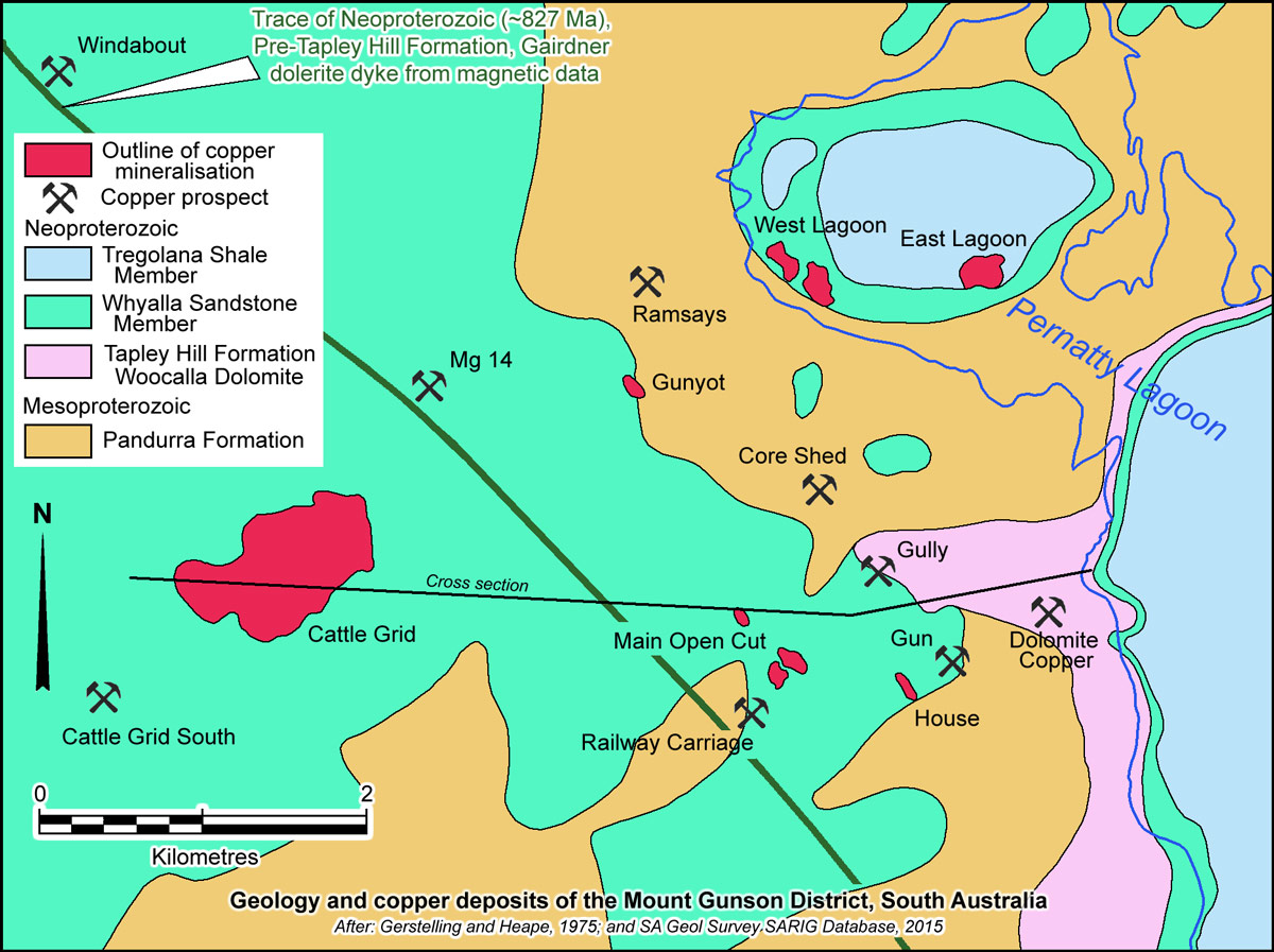
The Mount Gunson sediment hosted copper deposits, which includes Cattle Grid, Windabout, Main Open-cut, West Lagoon, East Lagoon, House, MG 14 & Gunyot are located 145 km NNW of Port Augusta and 110 km south of Olympic Dam in South Australia. The bulk of this group of deposits are distributed over an area of ~6 km east-west by 4 km north-south, both below Gunyah Lake, an inlet on the western margin of the Pernatty Lagoon playa lake, and onshore to the immediate west. The WNW-ESE elongated Windabout deposit is ~6 km north of Cattle Grid (#Location: Cattle Grid - 31° 26' 45"S, 137° 8' 27"E).
Copper oxides were discovered at the surface at Mount Gunson in 1875, with sulphide mineralisation located soon after. Mining has been undertaken intermittently since that time, with open-cut operations having been carried out on four orebodies - Main Open Cut, West Lagoon, East Lagoon and Cattle Grid. Cattle Grid, mined from 1974 to 1986, was the largest orebody and provided the great bulk of production. Significant resources remained in 2014, including the MG14, Windabout, Cattle Grid South and Sweet Nell deposits (DMITRE website, 2015).
Geological Setting
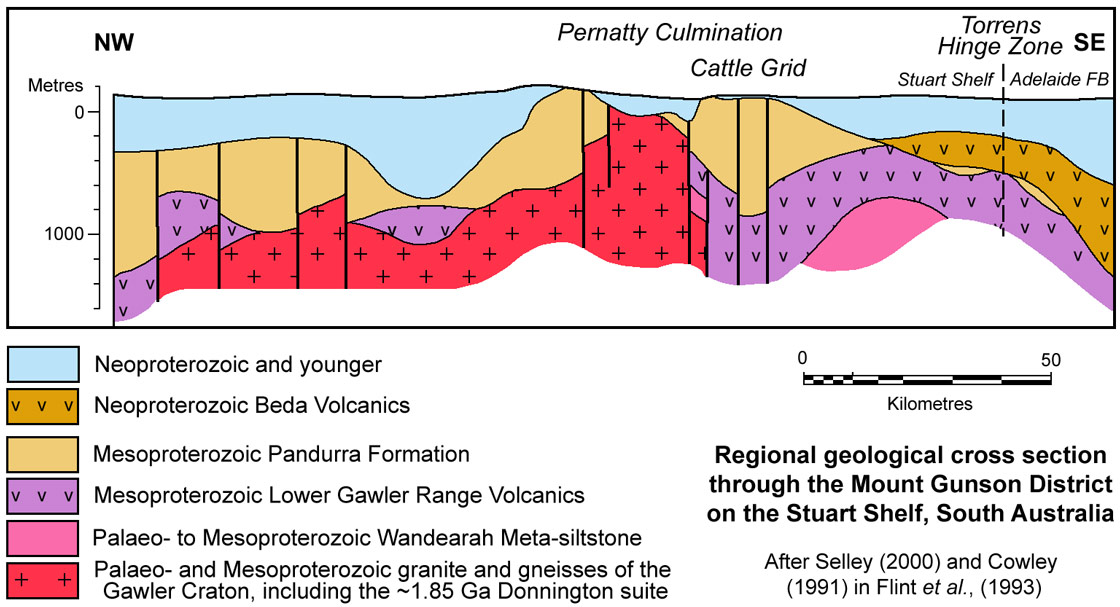
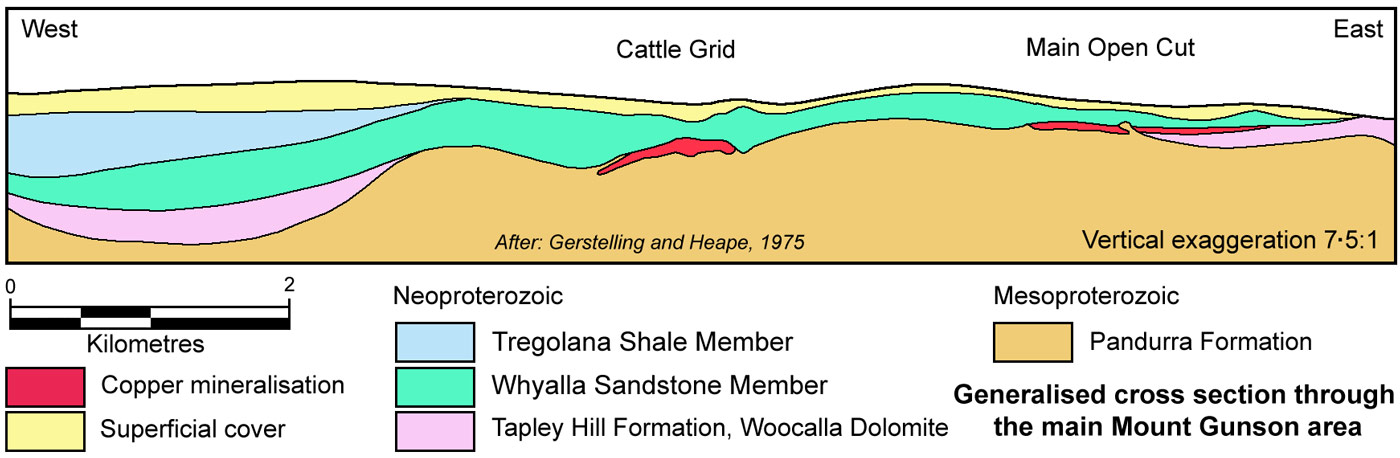
The Mount Gunson district deposits are hosted by shallow dipping to flat lying Neoproterozoic and Mesoproterozoic sedimentary rocks on the on the Stuart Shelf, on the eastern margin of the Gawler Craton and some 60 km west of the NNW-trending Torrens hinge zone which separates the shelf from the deeper Adelaide Fold Belt and Rift Basin to the east. The deposit lies on the same NNW trending, transcontinental gravity lineament that also passes below Olympic Dam. Mineralisation is developed over a horst of Mesoproterozoic Pandurra Formation, which represented a basement high during Neoproterozoic sedimentation. This basement high surrounded by onlapping, thinned and outward dipping Neoproterozoic units is known as the Pernatty Culmination, and extends over a north-south interval of >130 km, and underlies both the Mount Gunson and Emmie Bluff sediment hosted copper deposit groups (Selley et al., 2000). It corresponds to a horst and upwarp of Pandurra Formation and underlying basement rocks.
Basement to the Pandurra Formation is largely composed of rocks of the eastern Gawler craton, that predominantly includes ~1.85 Ga granitic to charnokitic and mafic magmas of the Donington Suite, and the felsic and mafic magmas of the 1.6 to 1.59 Ga Lower Gawler Range Volcanics suite, largely composed of dacite to rhyolite, andesite and basalt. A ENE-WSW trending, 40 x 15 km, high density anomaly in residual gravity data that underlies the Mount Gunson section of the Pernatty Culmination has been interpreted to reflect altered basalt of the Lower Gawler Range Volcanics. The 1.595 to 1.575 Ga Hiltaba Suite oxidised granitic rocks may also be represented. On the eastern margin of the craton, the Gawler Range Volcanics are underlain by the Wandearah Formation, composed of argillite, quartz siltstone, carbonates, and calc-silicate, iron-rich and carbonaceous metasediments that were deposited between 1.76 and 1.74 Ga and deformed by the 1.73 to 1.69 Ga Kimban Orogeny.
The Pandurra Formation, which is <1000 m thick, is an unmetamorphosed, dominantly fluviatile red-bed sequence that is >1425Ma and <1592 to 1589 Ma in age. The latter is the age of the underlying Roopena Volcanics, which occur in the basal sections to the Pandurra Formation and are grey-green altered basaltic flows with amygdaloidal tops and are a late phase of the Gawler Range Volcanics. The Pandurra Formation is known to extend from near Whyalla in the south to north of Olympic Dam, within a 120 km wide graben like depression (Parker, 1983) with an overall tilt to the NE that is known as the Cariewerloo Basin. It comprises a poorly-sorted, medium to coarse-grained, subangular quartz and lithic sandstone with minor conglomerate, mudstone and siltstone. Pebbles of volcanic fragments and quartz are common towards the base of the formation at Cattle Grid. It displays large-scale cross-bedding and graded bedding. Sedimentary rocks contain clear quartz grains, originally sub-rounded, cemented by kaolinite and hematite which have subsequently been replaced by chert and quartz. There appears to have been a considerable period of erosion before the overlying units were deposited, with the resulting palaeo-surface, consisting of low hills and broad valleys, now defined by fossil scree deposits and possible palaeosol horizons. In the Mt Gunson district, the Pandurra Formation is silicified to depths of up to 150 m below the unconformity, interpreted to represent palaeo-weathering prior to the deposition of the Neoproterozoic sequence described below.
The Pandurra Formation is unconformably overlain by the Neoproterozoic Appila Tillite, a discontinuous unit of shale, sandstone, quartzite and conglomerate, deposited in thin beds above the Pandurra palaeo-surface, representing the base of the Umberatana Group.
These beds are followed by the Neoproterozoic (>643±2.4 and <750±63 Ma; Geoscience Australia) Tapley Hill Formation, which is part of the Umberatana Group and comprises an up to 200 m thick sequence of grey, bedded to laminated shale and dolomitic shale with thin silty dolomite and sandstone. This regional unit extends from south of Adelaide within the Adelaide Rift Basin in the east, onto the the Stuart Shelf and to the north and west of Mt Gunson and Olympic Dam. At Mt Gunson it is represented by the Woocalla Dolomite member (now known as the Brighton Limestone) that includes black shale, dolomitic shale, oolitic dolomite, stromatolitic dolomite and dolomite muds and clay. This unit represents a period of submergence over much of the Pandurra surface creating conditions of shallow lagoonal mud flats adjacent to an arid shoreline of Pandurra Formation, although dolomitic shales are lacking further offshore. The depositional environment is indicated by sedimentary features such as closely spaced cyclic interlensing of mud and dolomite layers, desiccation cracks, stromatolites, and intraclast and edgewise breccias at Mount Gunson. Laminations are commonly <0.5 mm thick, and the dark color of the clastic mudstone lenses reflects a high pyrite content and, to a lesser extent, the presence of organic matter. The mudstone lenses are made up of angular and subangular quartz and minor feldspar. Illite and kaolinite are the principal clay minerals. Oxide minerals include magnetite, hematite, goethite, limonite, ilmenite, anatase (Knutson et al., 1983).
Away from the Pernatty Culmination, the Tapley Hill Formation is overlain by mudstones and sandstones of the Yudnapinna Beds, which are composed of quartzose mudstone and sandstone with a volcanic lithic component. The lower section is usually grey to green, passing upward to a red-brown or white colouration. They grade upward into the Whyalla Sandstone. However, the Yudnapinna Beds wedge out against the margins of the Pernatty Culmination and the Whyalla Sandstone progressively oversteps to directly overlie the Tapley Hill and then the Pandurra Formations (Knutson et al., 1983).
The next unit of the Umberatana Group, the Whyalla Sandstone is ~65 m thick and comprises a mature, bimodal lithic quartz arenite, composed of quartzite and carbonate clasts and grains of probable Pandurra and Tapley Hill Formations derivation, variably gritty siltstones to sandstones, minor dolostone, and locally stromatolitic, interbeds. Aeolian, reworked aeolian, and alluvial grains are present (Knutson et al., 1983; Vella and Cawood, 2006). In the core of the Pernatty Culmination, it overlaps the Woocalla Dolomite to rest directly on the Pandurra Formation. At Cattle Grid it contains spherical, frosted sand grains, and is of aeolian to deltaic origin, with quartz, feldspar and rock fragments in varying proportions, cemented by a fine silt and clay matrix, which in the lower 5 to 10 m locally renders it impermeable. The beds are essentially sub-horizontal although some cross-bedding and slumping does occur (Gersteling and Heape, 1975). The basal Whyalla Sandstone was contemporaneous with the Marinoan glaciation, which is interpreted to have resulted in frost shattering of the upper silicified surface of the Pandurra Formation, forming a palaeo-permafrost breccia known as the Cattle Grid Breccia, which in part hosts to the orebody. This breccia is accompanied by other interpreted periglacial structures within the upper surface of the Pandurra Formation, including sand wedge polygons and injections, anticlinal folding and faulting caused by frost heaving and thrusting. Similar periglacial structures are evident in the basal Whyalla Sandstone and upper Tapley Hill Formation where it underlies the Whyalla Sandstone (Tonkin and Creelman, 1990).
The Whyalla Sandstone is overlain regionally by the Tregolana Shale Member (or Woomera Shale - laminated red, brown and green, partly micaceous, shales), the Corraberra Sandstone (red-brown silty sandstones and flaggy, micaceous siltstones) and the Simmens Quartzite (a cream coloured, blocky quartzite to sandstone,which caps mesas throughout the region). The sequence from the Whyalla Sandstone to Simmens Quartzite are units within the Tent Hill Formation, part of the Umberatana (or Wilpena) Group.
Regionally the Stuart Shelf basement sequence and Pandurra Formation is intruded by the pre-Tapley Hill formation, continental scale mafic Gairdner Dyke Swarm, dated at 867±47 and 802±35Ma (Sm-Nd); 827±6Ma (U-Pb; Geoscience Australia). The associated Beda Volcanics (possibly fed by the Gairdner Dykes), composed of up to 700 m of locally amygdaloidal fine- to medium-grained basaltic lava, that regionally occur at the base of the Neoproterozoic sequence, are absent at Mt Gunson. However, they have been intersected in drilling to the east and south of the Pernatty Culmination (Tonkin and Creelman, 1990). These volcanic rocks are typically markedly hematised and chloritised (Knutson et al., 1983).
Locally, basic dykes of the Gairdner Swarm intruded the Pandurra Formation. At Mt. Gunson one such dyke contains trace amounts of pyrite and copper sulphides, especially associated with carbonate veins (Gersteling and Heape, 1975).
The horst of Pandurra Formation of the Pernatty Culmination forms a core surrounded by onlapping Whyalla Sandstone, which is, in turn, overlain by Woomera/Tregolana Shale. Outward from the culmination, the underlying Tapley Hill Formation also laps onto the basement horst, before being overstepped by the Whyalla Sandstone.
Mineralisation
Two types of mineralisation are recognised, namely:
• Sandstone breccia and sandstone hosted deposits at the contact of the Pandurra Formation and the overlying Whyalla Sandstone where the Tapley Hill formation is absent. Cattle Grid, which is 4 km west of the original Mt Gunson deposit (i.e., Main Open Cut), is of this type, hosted in a breccia in the upper surface of the silicified and brittle Pandurra Formation, and in the overlying, normally red Whyalla Sandstone, which is reduced over the structural culmination and ore zone. Cattle Grid is a sheet of breccia/fracture filling veinlets of sulphides in a 1400 x 600 m sheet that averages 4.5 m in thickness (Tonkin and Creelman, 1990).
Copper mineralisation within the Cattle Grid Breccia occurs as a network of fracture filling veins that average 2 mm in thickness, but may be up to 30 mm, with a vertical zonation in texture. The upper parts of the breccia are more intensely brecciated and more densely veined with Cu sulphides. The brecciation and veining diminishes downward with a decrease in vein density, vein width and grade. Jointing with NNE and WNW orientations, persists below the glacial brecciation zone, with some being weakly mineralised to depths of as much a 130 m below the unconformity. The former are more richly mineralised, and parallel to the main elongation of the ore zone at Cattle Grid (Tonkin and Creelman, 1990).
The other deposits of this type include Main Open Cut, East and West Lagoon, House and Gunyot, although the breccia is not as well developed at any of these compared to Cattle Grid (Tonkin and Creelman, 1990).
In the Lagoon deposits, but not at Cattle Grid, copper sulphides occur as a matrix to the Whyalla Sandstone and are a minor but important ore type. The Whyalla Sandstone in these deposits is more permeable than at Cattle Grid, but is capped by the impermeable Woomera Shale (Tonkin and Creelman, 1990).
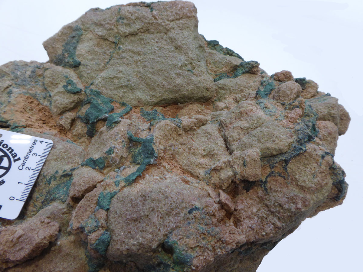
Above: Mineralised perma-frost brecciated Pandurra Formation sandstone collected from a mine face in the Cattle Grid pit, above the base of oxidation.
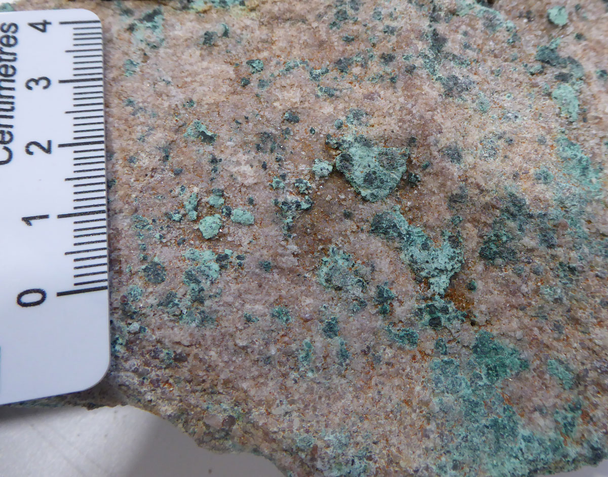
Below: Mineralised Whyalla Sandstone from the Cattle Grid pit, also from above the base of oxidation. Note the dark bornite grains/patches which are nucleated on earlier sulphides and on silicate grains, and have been subsequently oxidised to varying degrees.
Samples collected by Geological Survey of South Australia, image by Mike Porter, November 2021.
The Cattle Grid deposit has an asymmetric lateral mineral zonation, with a 'core' of chalcopyrite in the least permeable host to the NW, rimmed by bornite and then chalcocite to the SE, in the most brecciated/permeable sections of the sheet. There is little vertical zonation evident. The chalcocite zone is characterised by mineral crustification and vug filling, with some crystal of up to 3 mm length (Tonkin and Creelman, 1990).
The principal sulphides are of copper, although significant zinc and lead, and some bismuth and cobalt, are also present. Zinc is found in both the chalcopyrite and chalcocite zones occurring as sphalerite, while galena is largely restricted to the chalcocite zone as a late vein filling phase. Bismuth is concentrated in the chalcocite zone, mainly as wittichenite, and rarely as native bismuth, while cobalt is dominantly present as carrollite. Appreciable Ni (accompanying the carrollite) and As (in early pyrite), traces of Ag (associated with the bornite and chalcocite) and rare traces of Au are present (Tonkin and Creelman, 1990).
Mineralisation exhibits evidence of multiple dissolution and redeposition obliterating early textures and assemblages. The earliest sulphides recognised occur as spherical concretions, with carrollite cores rimmed by multiple arsenical pyrite. In general, there appears to have been lesser early Fe sulphides than later Cu sulphides suggesting another source of sulphur, although the bornite and chalcocite appears to have been nucleated on chalcopyrite (Tonkin and Creelman, 1990).
An unusual feature is the colloform late banding of Cu-Fe and Cu sulphides, interpreted to have been due to near surface redeposition by recent ground waters and bacterial reduction. Sulphur isotope studies show a difference between the sulphides from the deposits below the reduced recent sediments of the Lagoon, compared to the oxidising surface conditions away from the lagoon (e.g., at Cattle Grid). The geometry of the Cattle Grid deposit indicate the most recent influence was from an oxidising fluid flowing down dip to the NW. The small Gunyot deposit is above the water table and is entirely oxidised. The Main Open Cut and House deposits straddle the water table and hence contain oxide and sulphide assemblages respectively above and below (Tonkin and Creelman, 1990).
• Black shale hosted deposits in the Tapley Hill Formation, which occur on both the upper and lower margins of the unit where it laps onto the culmination and local rises in the Pandurra Formation unconformity surface over the Pernatty Culmination, particularly where it is onlapped by the Whyalla Sandstone. These outer fringes or crusts of mineralisation are best developed (thickest) where the black shale is more permeable. The Windabout and MG14 deposits are the best examples.
Windabout, occurs as a flat-lying, 2 to 3 m thick, ~1500 x 500 m sheet at a depth of 60-70 m below surface. Mineralisation was controlled by the Marinoan disconformity at the base of the Whyalla Sandstone, where the principal host was a permafrost breccia horizon on the upper surface of the black dolomitic shales of the Tapley Hill Formation. Copper sulphide mineralisation, comprising chalcocite, bornite and chalcopyrite, formed a cement in more porous dolarenite clasts in the breccia, and in dolarenite laminae in the underlying black shale (DMITRE SARIG database).
MG14, represents a NW-trending structural basin containing remnant Tapley Hill Formation strata over the Pernattay Culmination. Mineralisation occurs at both the upper and lower margins of the Tapley Hill Formation, at the contacts with the Whyalla Sandstone and Pandurra Formations respectively. The better grades (up to 5% Cu) are in a narrow zone ~0.5 m thick at the upper contact, where periglacial breccias similar to those in the Pandurra Formation at Cattle Grid, also immediately below the Whyalla Sandstone, are developed and mineralised. Mineralisation favours the more permeable clasts, rather than the black dolomitic mud matrix facies, and extends from the breccia, downwards into the underlying undisturbed shale, favouring similar permeable lithologies (Knutson et al., 1983). The lower mineralised contact is up to 3 m thick with grades of ~1% Cu, concentrated in the coarser grained, more permeable dolarenite laminae, rather than the finer black dolomitic mud laminae. This lower mineralised zone is mostly underlain by oxidised red and green sandstones, shales and conglomerate/diamictite of the Appila Tillite which occupied palaeo-steam beds in the Pandurra land surface. The red facies contain oxidised pseudomorphs after sulphides indicating they were originally reduced and have been subsequently been oxidised by percolating fluids (Knutson et al., 1983).
The main sulphide minerals in the Tapley Hill Formation are pyrite, chalcopyrite, bornite, chalcocite, galena, sphalerite and carrollite, with lesser marcasite, covellite, linnaeite and wittichenite (Curtis, 1974). Pyrite generally occurs as framboids in clastic mudstone lenses and as fine-grained euhedra in the dolostone. Wrapping of bedding around pyrite grains and by the presence of mineralisation in dewatering structures which show evidence of soft sediment deformation indicates that some of the pyrite was formed before lithification (Knutson et al., 1983).
Within the main zones of Cu mineralisation, pyrite framboids are partially or completely replaced by bornite, chalcocite and, to a lesser degree, chalcopyrite (Knutson et al., 1983).
Small discrete grains of colourless to pale yellow sphalerite are associated with pyrite and Cu-Fe sulphides, and sometimes replace pyrite or rim pyrite, chalcopyrite, and bornite. Sphalerite more commonly, occurs with coarsely crystalline bedded and vein-filling carbonate±Cu-Fe sulphides, galena and secondary quartz. Stringer veins containing sphalerite (±Cu-Fe and Pb sulphides) are most common in the dolomite lenses (Knutson et al., 1983).
Geochemistry and Timing
There is a positive correlation between Cu, Pb, Zn and S within the main Cattle Grid deposit, whilst in the more weakly mineralised, lower parts of the orebody there is an association of Zr, Cu, Pb and Co (Knutson et al., 1983). However, there is no correlation between Fe203 and S03 in the Pandurra Formation, suggesting Fe and S were introduced separately, most likely as heavy minerals (Fe-Ti-Zr oxides) and a sulphate derived solution respectively (Knutson et al., 1983). These relationships are consistent with the partial replacement of detrital heavy minerals by base-metal sulphides. In contrast, there is a strong positive correlation of Fe203 and S03 in the overlying Whyalla Sandstone. In addition, there is a positive correlation of Cu and S03 in both the Pandurra Formation and Whyalla Sandstone implying either coeval introduction of Cu and S or complete and/or consistent levels of replacement of pyrite by Cu (Selley et al., 2000 and references cited therein).
Base-metal sulphides at the Cattle Grid deposit contain light δ34S values of -15.1 to -3.7‰, suggesting S-derivation by biogenic sulphate reduction in the implied absence of high-temperature fluids (Knutson et al., 1983).
Similar elemental associations are recorded for mineralisation within the Tapley Hill Formation-hosted deposits, where there is also enrichment in As, Co and Ni, with elevated Mn and Ba in dolomitic units (Selley et al., 2000 and references cited therein). S-isotope values from base metal sulphides in the Tapley Hill Formation display a wide and unsystematic variation (-3.6 to +44.6‰) and isotopic disequilibrium between coexisting sulphide phases (Knutson et al., 1983; Lambert et al., 1984).
Knutson et al. (1983) noted the following relationships in the Mount Gunson deposits:
• Both pyrite and Cu-Pb-Zn sulphides in the Pandurra Formation were formed after at least one, and possibly two, periods of exposure and brecciation, with the second weathering occurring during periglacial activity associated with the Marinoan glaciation.
• Base metals concentrated in the brecciated surface of the Pandurra Formation frequently occur in areas where the Tapley Hill Formation is absent from the base of the sequence and the mineralisation is directly overlain by the Whyalla Sandstone.
• Similarly, Cu-Pb-Zn zonation in the upper parts of the carbonaceous and calcareous Tapley Hill Formation suggests that the overlying Whyalla Sandstone (which is characterised by the absence of organic matter) acted as an aquifer for mineralising fluids.
• Cu-Fe sulphide minerals replace earlier pyrite in both the Pandurra and Tapley Hill Formations.
• Framboidal pyrite in the Tapley Hill Formation was formed while the sediments were still soft, as suggested by the presence of sulphides within
dewatering structures and wrapping of compacted sedimentary layers around partly replaced pyrite grains.
• Concentration of Cu-Pb-Zn mineralisation along both the upper and lower disconformable surfaces of the Tapley Hill Formation, as well as with their preferential concentration in more permeable lenses, implies mineralisation occurred after deposition and some compaction of the host unit.
• The absence of the oxidation of mineralisation in the Cattle Grid deposit suggests sulphide mineralisation has not been subjected to a weathering regime prior to deposition of the Whyalla Sandstone.
• An increase in Fe content in the Whyalla Sandstone immediately overlying the Cu-mineralised zone in the Pandurra Formation suggests Fe displaced by the mineralising event migrated into the Whyalla Sandstone (or this was an outlet zone for Fe-enriched waters).
These observations suggest the Whyalla Sandstone acted as an aquifer for the introduction of mineralising fluids prior to the lithification of the Neoproterozoic sequence. Mineralisation was deposited in permeable locations (e.g., brecciated Pandurra Formation, the Whyalla Sandstone and sandy facies of the Tapley Hill Formation). Sulphate solutions first reduced Fe-Ti-Zr oxide heavy minerals in the sandsone hosts of the Pandurra Formation and adjacent Whyalla Sandstone to form pyrite. This pyrite, and diagenetic pyrite in the Tapley Hill Formation were later replaced by oxidised base metal bearing fluids to form base metal sulphides, decreasing in intensity away from the Whyalla Sandstone interface. The replacement of Fe in pyrite by base metals, resulted in the expulsion of Fe oxides into the migrating fluid, to be deposited above in the Whyalla Sandstone aquifer. It is unusual that mineralisation is concentrated in hosts at the base of the aquifer, rather than its top.
Production and Resources
Production to 1989 was: 0.149 Mt of contained Cu and 65 t Ag (Tonkin and Creelman, 1990).fig. 5
Production from the main period of operation, 1974 to 1986 was: 8.4 Mt @ 1.7% Cu (DMITRE website, 2015).
Resource estimates of remaining ore include (Torrens Mining, 2014), at a 0.5% Cu cut off:
Windabout, indicated resource - 18.7 Mt @ 0.96% Cu, 0.05% Co, 10 g/t Ag;
MG 14, indicated resource - 1.62 Mt @ 1.4% Cu, 397 ppm Co, 14 g/t Ag.
Resource estimates of remaining ore at Jan. 2018 include (Coda Minerals, Website viewed Nov. 2021), at a 0.5% Cu cut off:
Windabout, indicated resource - 17.67 Mt @ 0.77% Cu, 492 ppm Co, 8 g/t Ag (~1.41% Cu equiv.);
MG 14, indicated resource - 1.83 Mt @ 1.24% Cu, 334 ppm Co, 14 g/t Ag (~1.67% Cu equiv.).
NOTE: Windbout and MG14 are regarded as part of Coda Minerals' Elizabeth Creek Project which includes the larger Emmie Bluff sediment hosted mineralised system that is underlain by the IOCG deposit of the same name.
For detail consult the reference(s) listed below.
The most recent source geological information used to prepare this decription was dated: 2012.
Record last updated: 25/8/2015
This description is a summary from published sources, the chief of which are listed below.
© Copyright Porter GeoConsultancy Pty Ltd. Unauthorised copying, reproduction, storage or dissemination prohibited.
Cattle Grid
|
|
|
|
|
Gerstelling R W and Heape J M, 1975 - The Cattle Grid orebody, Mt. Gunson, South Australia: in Proceedings, The Aus.I.M.M. Conference. South Australia, June, 1975 The AusIMM, Melbourne, pp. 103-112
|
Knutson J, Donnelly T H and Tonkin D G, 1983 - Geochemical constraints on the genesis of copper mineralization in the Mount Gunson area, South Australia : in Econ. Geol. v.78 pp. 250-274
|
Knutson J, Donnelly T H, Eadington P J and Tonkin D G, 1992 - Hydrothermal alteration of middle Proterozoic basalts, Stuart Shelf, South Australia; a possible source for Cu mineralization : in Econ. Geol. v.87 pp. 1054-1077
|
Rattigan J H, Van Herk H and Gelding P W, 1979 - Ore reserve estimates and comparison with mine production from the Cattlegrid orebody, Mt Gunson, South Australia: in Proceedings, The Aus. I.M.M. Sydney Branch, Estimation and Statement of Mineral Reserves, October 1979 The AusIMM, Melbourne, pp. 195-206
|
Tonkin D G, Creelman R A 1990 - Mount Gunson Copper deposits: in Hughes F E (Ed.), 1990 Geology of the Mineral Deposits of Australia & Papua New Guinea The AusIMM, Melbourne Mono 14, v2 pp 1037-1043
|
Tonkin, D., 2019 - Recognition and definition of the copper-hosting Whyalla Sandstone, South Australia: in Mesa Journal v.89, pp. 39-44.
|
|
Porter GeoConsultancy Pty Ltd (PorterGeo) provides access to this database at no charge. It is largely based on scientific papers and reports in the public domain, and was current when the sources consulted were published. While PorterGeo endeavour to ensure the information was accurate at the time of compilation and subsequent updating, PorterGeo, its employees and servants: i). do not warrant, or make any representation regarding the use, or results of the use of the information contained herein as to its correctness, accuracy, currency, or otherwise; and ii). expressly disclaim all liability or responsibility to any person using the information or conclusions contained herein.
|
Top | Search Again | PGC Home | Terms & Conditions
|
|


