|
Chatree |
|
|
Thailand |
| Main commodities:
Au Ag
|
|
 |
|
 |
 |
Super Porphyry Cu and Au


|
IOCG Deposits - 70 papers

|
All papers now Open Access.
Available as Full Text for direct download or on request. |
|
 |
The Chatree low to intermediate sulphidation epithermal gold deposit is located in northern Thailand, 280 km north of Bangkok and 45 km southeast of the provincial capital of Pichit (#Location: 16° 17' 54"N, 100° 39' 4"E).
The Chatree gold deposit was discovered by a team of Thai and Australian geologists in the 1990s. Mining operations commenced in 2001, and to 2016 had produced 56 tonnes of gold and over 300 tonnes of silver. The mine was idle between 2017-2021 when a key processing licence wasn’t renewed. Kingsgate undertook action under the Thai-Australia Free Trade Agreement and following an international legal process, and negotiations with the Thai government, Chatree officially reopened in March 2023. Following an extensive refurbishment of the processing plants and the arrival of new mining equipment, full mining operations recommenced in mid 2024.
The mineralisation is located within a zone composed of parallel, north-south trending Upper Permian and Triassic volcanic arc sequences of island arc acid to intermediate volcanic and marine sedimentary rocks formed above a subduction zone prior to and during the collision of the Southeast Asian and Shan-Thai crustal blocks. It falls within the Loei-Pechabun Belt that extends from northern Laos to central Thailand which also contains low sulphidation epithermal gold, copper-gold skarn and porphyry copper occurrences. Multiple plutons and small batholiths of Late Carboniferous to Triassic granites occur within the arc.
In the Chatree district, the host sequence is composed of Middle Permian to Upper Triassic volcanic suites of rhyolite, dacite, andesite and basaltic andesite flows and their pyroclastic equivalents. Middle Triassic tuffaceous sediments, limestone and chert occur throughout the district. Bedding dips are of the order of 10 to 30°, while the dominant fault trends are north-south, NE and NW.
Two circular features, each with a diameter of 20 to 30 km have been detected in the Chatree district and are interpreted as possible calderas. Both are cut by NW and NE trending faults. Granodiorite and diorite porphyry stocks up to 4 km in diameter are mapped and interpreted from airborne magnetic data, while doleritic and dioritic dykes are common.
The Chatree gold deposit is hosted by Upper Permian to Upper Triassic volcanic arc porphyritic latite-trachyte flows, their pyroclastic equivalents and volcaniclastic rocks, and subordinate fine to medium grained volcaniclastics, all of which have been silicified over an area of 7.5 x 2.5 km.

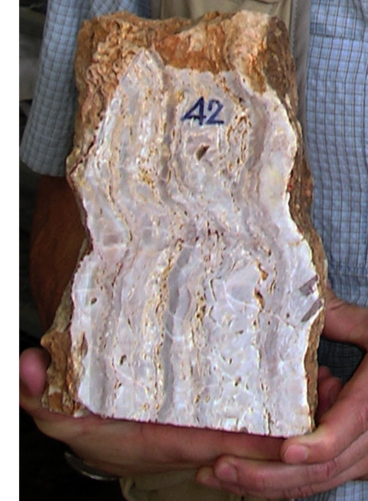
Oxidised epithermal textures from the original outcrop over the Chatree deposit. Image by Mike Porter, 2007.
The sequence is as follows, from the base:
- potash feldspar microporphyritic to porphyritic latite trachyte flows - undetermined thickness;
- interlayered and interfingered latite-trachyte flows and crystal/lithic/vitric tuffs and fine lapilli tuffs of porphyritic latite trachyte composition, with volcaniclastics, containing sandstones, siltstones, cherts and volcanic clasts - 200 m thick;
- lapilli tuff and clast supported agglomerate with subordinate crystal/lithic/vitric tuffs, volcanclastics and rare flows - up to 120 m thick.
Dykes of varying composition from andesite to basalt, as well as quartz monzonite, monzodiorite, latite and trachy-andesite, cut the sequence.
Overall, gold occurs in an adularia-sericite epithermal system within quartz-calcite-adularia veins, breccias and stockworks deposited in dilational zones during repeated reactivation of pre-existing structures.
Multiple phases of veining and alteration are recognised, generally being more intense in the vicinity of veins and breccias. There are at least 5 stages of veining in the lower levels of the deposit and three in the upper. Early vein assemblages are dominated by quartz, calcite, adularia and pyrite, followed by quartz, calcite, chlorite, ferroan dolomite, illite-smectite, pyrite and then quartz, calcite, pyrite. Post dyke alteration was less developed and mainly calcite with local epidote and adularia.

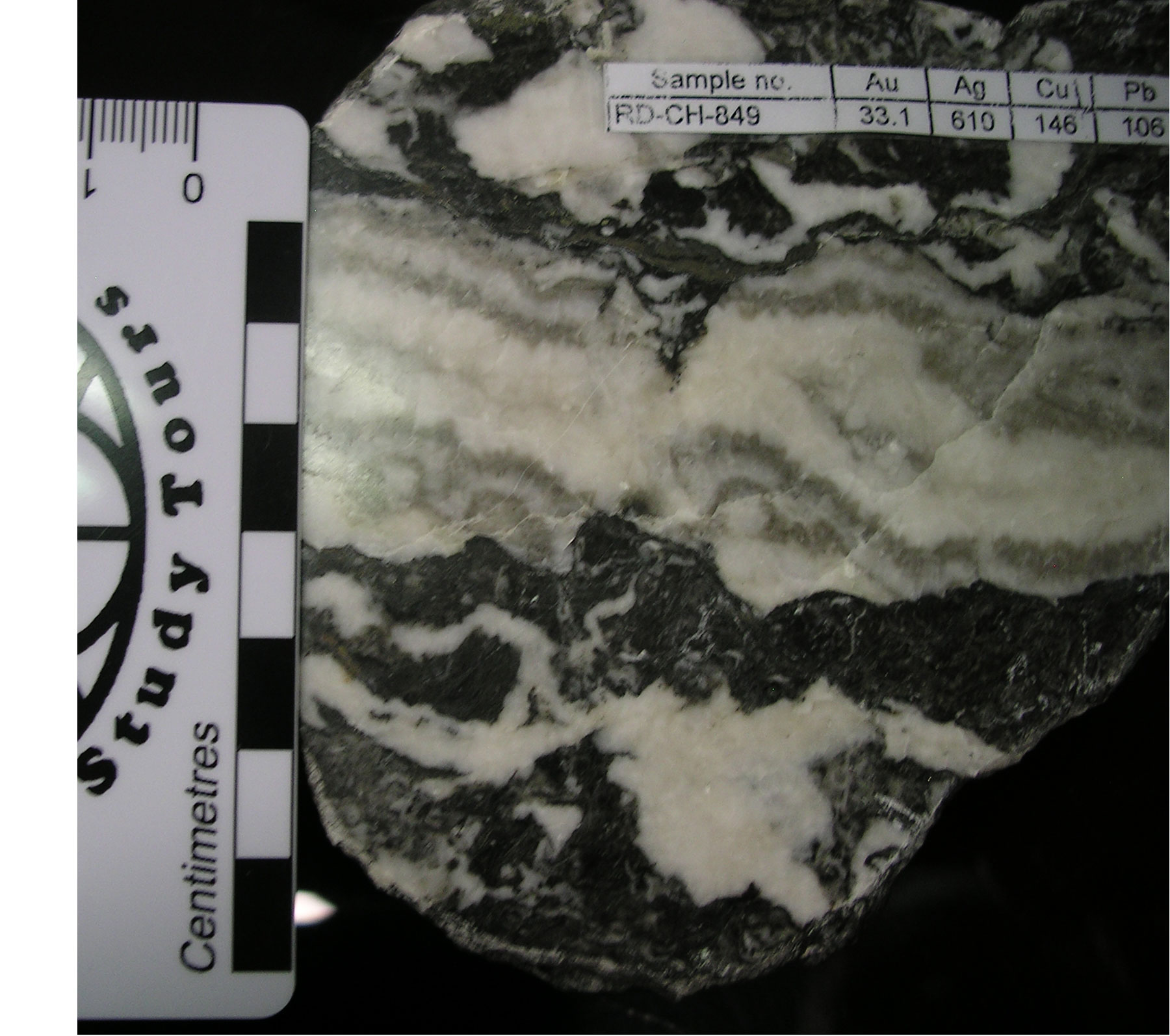
Un-oxidised epithermal textures and assays (in ppm), from one of the veins of the Chatree deposit. Image by Mike Porter, 2007.
Each of the mineralised zones is associated with a major structure, trending at between 40 and 350° and dips that vary from vertical in some zones to as little as 20° in others. In each zone there has been repeated dilation to produce crustiform banding in the veins. Most veins have breccias developed on their margins, with a wide variety of angular to subrounded clast types. Stockwork and sheeted veins are common in the wall rocks. Individual veins may be a few mm to tens of metres in thickness and extend down dip for up to 400 m (in shallow dipping veins) to depths of as much as 170 m. The maximum depth of mineralisation is 280 m from the highest known point at 210 m ASL. The best grades are between 50 and 110 m ASL. Ore grades are found in quartz, carbonate veins, stockworks and breccias. There is around 2.5% sulphides which is almost exclusively pyrite with minor sphalerite, galena and chalcopyrite. The lateritised oxide zone averages 10 m in thickness, underlain by saprolite and a 30 m thick transition zone. In the primary zone the Ag:Au ratio averages 2.5:1 and 5:1 in the enriched oxides.
The most likely age of mineralisation has been taken to be Triassic.
Mining operations commenced in November, 2001 and from 2003 to 2011, 2.4 Mt of ore were treated per annum. The ore has a high metallurgical recovery (89 to 91%), with gold and silver extraction by standard Carbon in Leach (CIL) processing.
The total mineral resource, together with the previously mined ore, totals almost 150 t (5 Moz) of gold, at average grades of 1.2 g/t Au and 12 g/t Ag (Kingsgate Consolidate website, 2010).
In 2004 the project comprised five delineated prospects within an area of 7.5 x 2.5 km. Resources at that time totalled 31 tonnes of gold and 161 tonnes of silver. Grades varied over a wide range, but averaged 2.5 g/t Au. The Ag:Au ratio is 2.5:1 in the primary ore and 5:1 in the enriched zone. Gold mineralisation extends over a vertical interval of at least 280 m. Gold is visible and is accompanied by an average 2.5% sulphides, mainly pyrite, with associated galena and sphalerite.
Reserves and resources in September 2005 (Kingsgate Consolidated website, 2007) were:
Proven + probable reserve - 29.48 Mt @ 1.9 g/t Au, 18 g/t Ag = 54 t Au, 530 t Ag;
Measured + indicated + inferred resource - 52.05 Mt @ 1.9 g/t Au, 16 g/t Ag = 99 t Au, 833 t Ag.
Remaining reserves and resources at 30 June 2009 (0.5 g/t Au cut-off; Kingsgate Consolidated website, 2010) were:
Proven + probable reserve - 37.1 Mt @ 1.2 g/t Au, 12 g/t Ag = 45 t Au, 440 t Ag;
Measured + indicated + inferred resource - 81.7 Mt @ 1.18 g/t Au, 9 g/t Ag = 96.4 t Au, 750 t Ag.
Remaining reserves and resources at 30 June 2012 (0.3 g/t Au cut-off; Kingsgate Consolidated website, 2012) were:
Measured + indicated + inferred resource - 168.8 Mt @ 0.7 g/t Au, 5.8 g/t Ag = 118.5 t Au, 986 t Ag; including
Proven + probable reserve - 71.3 Mt @ 0.75 g/t Au, 7.8 g/t Ag = 53.8 t Au, 554 t Ag.
Remaining Mineral Resources at December 2024 (0.3 g/t Au cut-off; Kingsgate Consolidated Release, 18 December, 2024) were:
Measured Mineral Resource - 52.1 Mt @ 0.72 g/t Au, 5.9 g/t Ag, in open pit
Measured Mineral Resource - 3.7 Mt @ 0.44 g/t Au, 7.6 g/t Ag, in stockpiles
Indicated Mineral Resource - 67.5 Mt @ 0.71 g/t Au, 6.3 g/t Ag,
Inferred Mineral Resource - 52.1 Mt @ 0.61 g/t Au, 4.1 g/t Ag,
TOTAL Mineral Resource - 175.4 Mt @ 0.68 g/t Au, 5.5 g/t Ag = 119 t Au, 977 t Ag
Proven + Probable Reserve - 53.1 Mt @ 0.76 g/t Au, 7.2 g/t Ag = 40 t Au, 385 t Ag.
NOTE: Resources are inclusive of Reserves.
The most recent source geological information used to prepare this decription was dated: 2004.
This description is a summary from published sources, the chief of which are listed below.
© Copyright Porter GeoConsultancy Pty Ltd. Unauthorised copying, reproduction, storage or dissemination prohibited.
Chatree
|
|
|
|
|
Cumming G, James R, Salam A, Zaw K, Meffre S, Lunwongsa W and Nuanla-ong S, 2008 - Geology and mineralisation of the Chatree epithermal gold-silver deposit, Petchabun Province, Central Thailand: in Pacrim 2008, 24-26 November 2008, Gold Coast, Queensland, Australia, The AusIMM, Melbourne, Extended Abstracts Volume pp. 409-416
|
Diemar M G and Diemar V A 1999 - Geology of the Chatree epithermal gold deposit, Thailand: in Pacrim 99, International Congress on Earth Science, Exploration and Mining Around the Pacific Rim, Proc. Pacrim 99 Conference, Bali, Indonesia AusIMM, Melbourne pp 227-231
|
Diemar M G, 1999 - Chatree, a greenfields discovery in Thailand: in New Generation Gold Mines 99, Case Histories of Discovery, Perth, Nov. 1999, AMF Adelaide, Conference Proceedings, pp 109-116
|
Salam A, Zaw K, Meffre S, Golding S, McPhie J, Suphananthi S and James R, 2008 - Mineralisation and oxygen isotope zonation of Chatree epithermal gold-silver deposit, Phetchabun Province, Central Thailand: in Pacrim 2008, 24-26 November 2008, Gold Coast, Queensland, Australia, The AusIMM, Melbourne, Extended Abstracts Volume pp. 123-131
|
|
Porter GeoConsultancy Pty Ltd (PorterGeo) provides access to this database at no charge. It is largely based on scientific papers and reports in the public domain, and was current when the sources consulted were published. While PorterGeo endeavour to ensure the information was accurate at the time of compilation and subsequent updating, PorterGeo, its employees and servants: i). do not warrant, or make any representation regarding the use, or results of the use of the information contained herein as to its correctness, accuracy, currency, or otherwise; and ii). expressly disclaim all liability or responsibility to any person using the information or conclusions contained herein.
|
Top | Search Again | PGC Home | Terms & Conditions
|
|