|
Luanshya (Roan Antelope), Baluba, Muliashi |
|
|
Zambia |
| Main commodities:
Cu Co
|
|
 |
|
|
 |
Super Porphyry Cu and Au


|
IOCG Deposits - 70 papers
|
All papers now Open Access.
Available as Full Text for direct download or on request. |
|
|
The Luanshya (Roan Antelope), Roan Extension, Muliashi, Mashiba, Muliashi North and Baluba sediment hosted copper deposits are located at the southern end of the Zambian Copper Belt in southeastern Zambia, approximately 30 km southwest of Ndola and 40 km southeast of Kitwe (#Location: Luanshya - 13° 7' 9"S, 28° 22' 33"E; Baluba - 13° 3' 3"S, 28° 20' 9"E).
Mineralisation was first recognised at Roan Antelope (later to be known as Luanshya) in 1902. In 1927, Roan Antelope Copper Mines was incorporated by Rhodesian Selection Trust Group to develop a mine, concentrator and smelter at the site. The first ore was hoisted 4 years later, commencing production that continued until 2000. The peak production of 105 000 t of Cu was in 1960. The Baluba mine commenced operation in 1973. The Zambian copper industry, including Roan Antelope and Baluba, was nationalised in 1970, culminating in the formation of Zambian Consolidated Copper Mines in 1982. However, following the privatisation program that the Zambian government instituted in 1997, Luanshya and Baluba were bought by an Indian based group that formed Roan Antelope Mining Corporation of Zambia, which was placed in receivership in late 2000. Following heavy rains in 2001, the Luanshya dam overflowed, the Luanshya workings were flooded and the mine was officially closed permanently. At that stage, ~93% of the known resource had been exploited. The Baluba mine was reopened in 2004, after it was purchased from the receivers. In 2009, the Baluba and Muliashi deposits were purchased from the interim owners by the China Nonferrous Metals Mining Group Co Ltd (CNMC), and operations continued at Baluba under its subsidiary CNMC Luanshya Copper Mines Plc (CLM).
Regional & Structural Setting
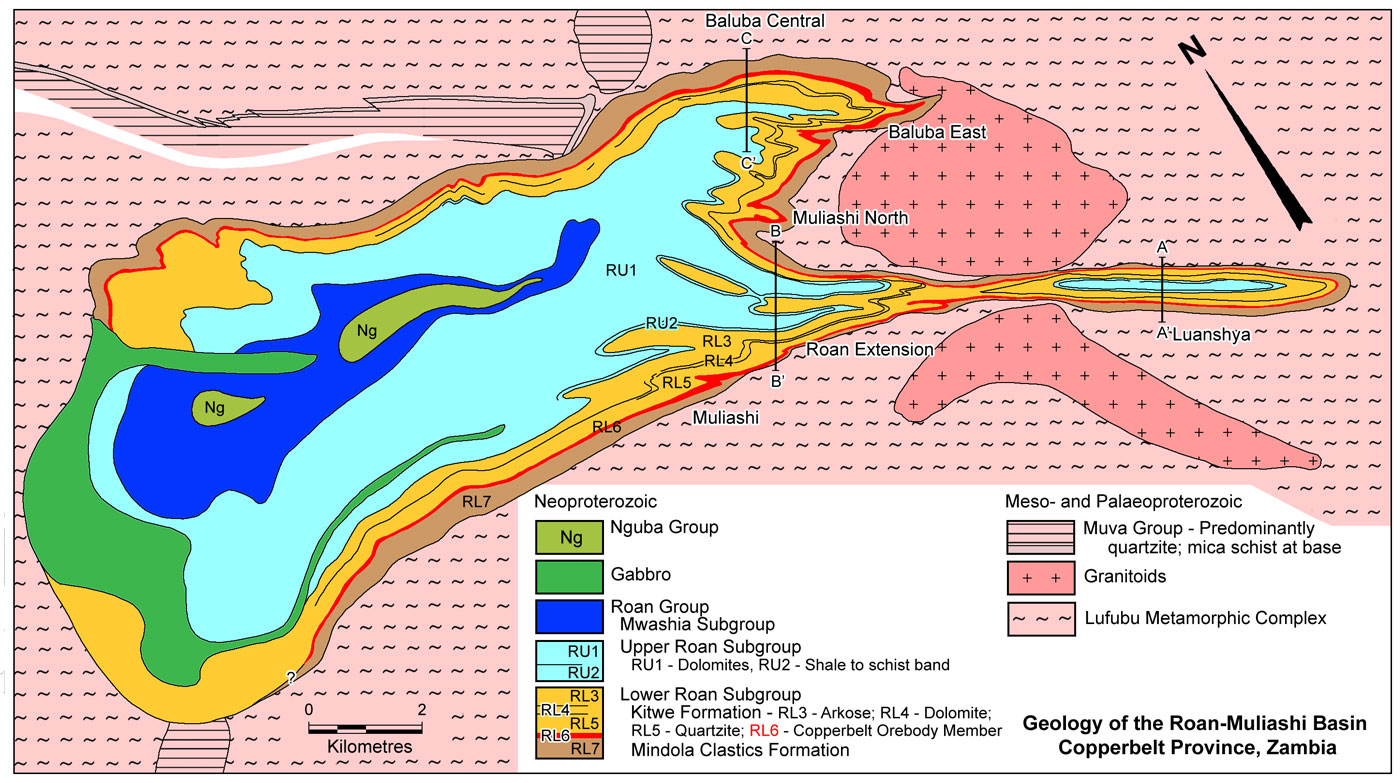
These deposits are located on the eastern margin of the Roan-Muliashi structural basin, an ~24 x <1 to >5 km, east-west elongated outlier of Neoproterozoic Katanga System rocks, unconformably overlying Palaeo- to Mesoproterozoic gneisses, granitoids and metasediments of the basement complex. The Roan-Muliashi structural basin is an east-west to ESE-WNW trending en echelon pair of doubly plunging synclines and an intervening anticline. In the western two thirds (15 km) of the structure, the mineralised Ore Formation of the Lower Roan Group is only exposed on the northern limb of the northern syncline and the southern limb of the southern structure, and does not emerge on the limbs of the central anticline in the core of the basin. These structures plunge inward, to the east and west on the western and eastern margins respectively, although the southern syncline fades to the west against the central anticline until the northern syncline becomes the dominant structure. To the southeast, the southern syncline has a long attenuated, tightly folded, ESE to SE elongated closure over a length of ~9 km, with the spacing between the limbs contracting westward to form a 'neck' before opening again to join the main broad structure. To the northeast, the northern, ~40°W plunging synclinal closure is much less attenuated. Mineralisation is also exposed on the anticlinal closure on the eastern margin of the structure. The broader, syncline pair and intervening anticline structure in the west is the Muliashi Basin, while the eastern, narrow, protruding, attenuated southern syncline is referred to as the Roan Basin (Lee-Potter in Mendelsohn, 1961; Fleischer et al., in Wolf (Ed.), 1976; SRK, 2012).
In the Roan-Muliashi Basin, the width of the structure, as defined by the exposed Ore Formation on the northern and southern limbs, varies from ~650 m at the widest section of the Roan Basin at Luanshya, to <200 m in the narrowest point of the Roan Extension neck that connects the Roan and Muliashi basins, opening out to the west in the latter to be ~5000 m.
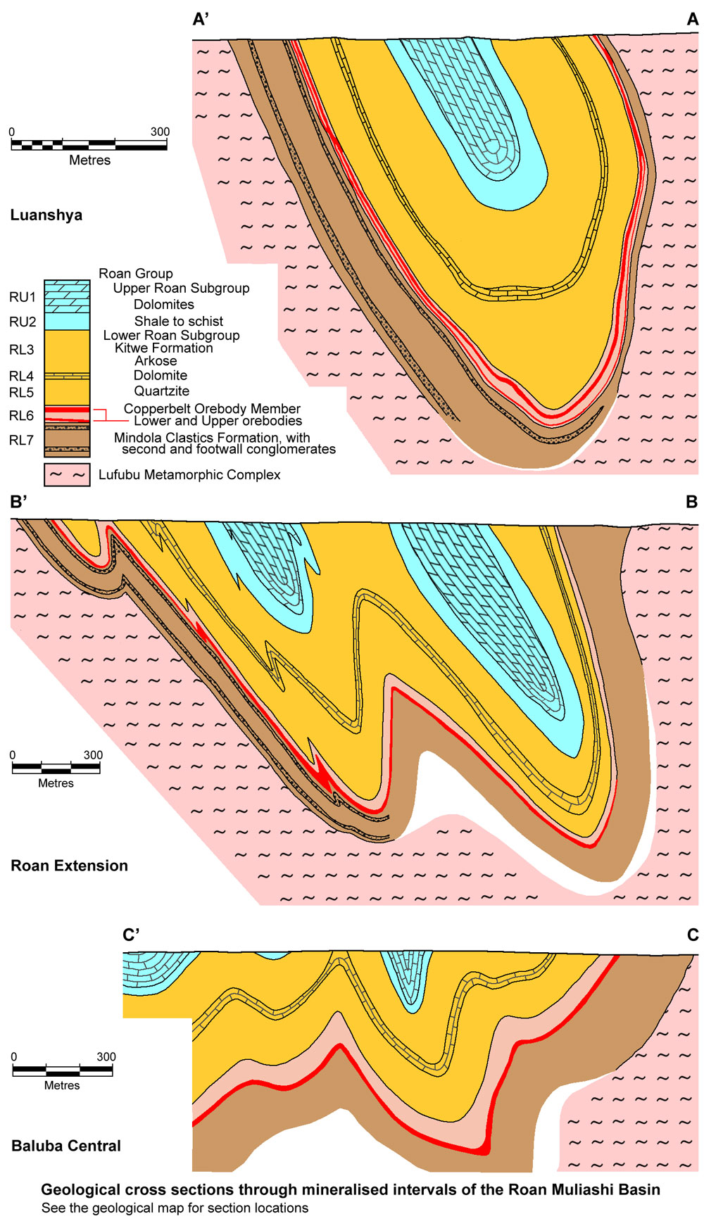
The southern syncline of the Roan Basin is overturned to the south, plunging at ~15°W from its eastern closure, with the keel in the Ore Formation reaching a maximum depth of 800 m, some 2800 m to the west, where it flattens. The syncline is steeply overturned to the south, with limbs dipping at <70°S to vertical, and minor parasitic folds developed near the keel. Further to the west, into the Roan Extension, the plunge of the keel is reversed, but becomes more tightly compressed, drag-folded and sheared, rising to a depth of <500 m with complicated en echelon folds. In this interval the fold is isoclinal, sandwiched between competent pre-Katangan granite which had formed a basement ridge during deposition of the Ore Formation, and after folding forms a deep cleft between which the Ore Formation is tightly wedged and extruded both up and down. Westward, into the western Roan Extension and into the Muliashi section, the folds become deeper and wider, and less tightly compressed, but still isoclinal. At Muliashi, the Ore Formation keel extends to a depth of ~1800 m, with limbs dipping at 55 to 85°, averaging 65°N, characterised by a series of tight, asymmetric drag folds. The northern limb of the northern syncline has a variable dip, generally overturned, dipping steeply to the north, with local reversals (Lee-Potter in Mendelsohn, 1961).
The axes of the main synclines and drag folds within the Roan-Muliashi Basin, consistently strike at close to 300°, and post-date any NW-SE structural trend. Significant faulting is largely absent, except for bedding plane shearing. Boudinage is common in competent (e.g., quartzite) beds within argillites, while the drag folding is most pronounced in less competent rocks such as argillites and dolostones (Lee-Potter in Mendelsohn, 1961).
Within the Roan-Muliashi structural basin, the Katanga System is represented by the conglomerates, quartzites, arkoses, argillites and dolomites of the Lower (~500 m) and Upper Roan (~650 m) Groups, the carbonaceous shales of the Mwashia Group (~100 m) and the tillites of the Kundelungu Group. The core of the main structural basin is occupied by rocks of the Upper Roan, Mwashia and Kundelungu Groups. In the western half of the basin, thick sills of gabbro intrude the Upper Roan carbonate rocks and the Mwashia Group. The Katangan sequence has been metamorphosed to greenschist facies, characterised by assemblages of biotite, quartz, microcline and carbonate (depending on the protolith) at ~200°C. Scapolite is a characteristic mineral in the Ore Shale to the west (Lee-Potter in Mendelsohn, 1961; Fleischer et al., in Wolf (Ed.), 1976; SRK, 2012).
The Luanshya (Roan Antelope) deposit is located in the Roan Basin, the eastern half of the extended eastern closure of the southern syncline. The Roan Extension is in the section of the same structure, that narrows, before expanding again and joining the main Muliashi Basin. Muliashi is on the southern limb of the southern syncline in the main structure, immediately to the west of Roan Extension. Mashiba is along strike on the southern limb of the Muliashi Basin, immediately to the west of Muliashi. Baluba is in the eastern closure of the northern syncline in the Muliashi Basin. Muliashi North lies in a structurally complex section of the anticlinal closure, between Muliashi and Baluba, on the eastern margin of the Muliashi Basin.
For details of the regional setting of the Roan-Muliashi basin, the Central African/Zambian Copper Belt and the Lufilian Arc, see the separate Zambian Copperbelt record.
Geology
The basement complex is composed of Palaeoproterozoic (~2.05 to 1.85 Ga) Lufubu System schists, largely quartz-biotite, biotite and chlorite schists, with minor feldspathic quartzites. The Lufubu Schists in the vicinity of the Roan-Muliashi basin are almost universally mineralised with sparsely disseminated pyrite, and locally chalcopyrite and pyrrhotite. These schists are intruded by large masses of granite, which are locally pink to grey, medium grained alkali granites. Both the Lufubu System and granites are unconformably overlain by the Mesoproterozoic Muva System quartzites and schists. The almost pure Muva quartzites are up to several hundred metres thick, separated by intercalated schists and schistose quartzites. The dominantly quartzite central section of the sequence is over- and underlain by light grey-green quartz-mica schist with abundant kyanite, local magnetite, and local quartzite intercalations (Fleischer et al., in Wolf (Ed.), 1976).
All of the economic mineralisation is confined to the Ore Formation of the 150 to 350 m thick Lower Roan Group, which is represented by the following succession on the eastern margin of the basin (after Lee-Potter in Mendelsohn, 1961; Fleischer et al., in Wolf (Ed.), 1976; SRK, 2012):
Mindola Clastics Formation or Footwall Formation, (RL7) 0 to 240 m thick - deposited on an uneven floor, punctuated by basement ridges separating sections of the sequence with different characteristics. This unit is best developed at Baluba, with more boulders, commonly of Muva System quartzite. It may be subdivided into,
Basal Conglomerate, locally developed in channels within the basement surface.
Argillaceous Feldspathic Arenites, 100 m thick - with lenticular conglomerates.
Aeolian Quartzite, 18 m thick - clean, well sorted, white to grey feldspathic arenite of aeolian origin.
Second Conglomerate, variable thickness - subrounded pebbles and cobbles of quartz, quartzite, granite and gneiss in a micaceous sandy matrix.
Argillaceous Quartzite, 15 m thick - with pre-consolidation slump structures. Hills of basement granite project through the sequence to this level.
Footwall Conglomerate, 0 to 2 m thick - a gravel blanket of 2 to 10 cm quartz and quartzite pebbles overlying both the Footwall Formation and the truncated basement hills protruding through that formation. This unit marks the commencement of the Ore Formation transgression.
Transition Schist, 0 to 2 m thick - a gritty dolomite schists or breccia, transitional with the underlying Footwall Conglomerate and overlying dolomitic basal layer of the Ore Shale. Locally pyrite, chalcopyrite, pyrite and bornite are disseminated in the upper parts of this unit.
Kitwe Formation, which commences with the:
Copperbelt Orebody Member or Ore Formation, (RL6) 15 to 55 m thick - which thins from ~55 m at Muliashi in the west to ~17 m on the eastern margin of the Roan Basin at Luanshya. It represents a transgression, started in the Footwall conglomerate, and has a regressive hanging wall. It commences with a zone of shearing and severe crumpling at the base against the more competent footwall sediments, and comprises, from the base,
Dolomitic Schist, 1 to 12 m thick - composed of impure banded dolomite which thickens to the west and has been sheared to a dolomitic schist (in places a barren talcose dolomite) during differential movement due to competency differences between the Ore and the Footwall Formations. It comprises 45 to 50% carbonates (dolomite and calcite), 20 to 25% biotite, 20% quartz, 5% microcline and 5% sulphides. It contains the bulk of the copper and cobalt of the Lower Orebody which only occurs in the central and western sections of the Roan Basin, and along the eastern margin of the Muliashi basin.
Ore Shale, 8 to >35 m thick - a fine-grained, dark grey, well bedded, biotitic quartz-feldspar argillite (biotite - 40%; carbonates - 7%; feldspar - 20%; sulphides - 7%; accessories - 1%), with occasional thin quartzite or arkose interbeds. Sandy interbeds are generally barren to only poorly mineralised. Over the granite basement-high in the Roan Extension section, cherty and talcose dolomite appears in the base of the Ore Shale on either margin of the basement ridge, and gradually steps up, until it occupies the whole thickness of the unit.
Two orebodies are recognised, the Lower, mainly in the dolomitic schist, but also the lower part of the Ore Shale, the Upper in the upper half of the Ore Shale. Both orebodies, although laterally very extensive along strike, are transgressive, cutting across the stratigraphy at a very low angle.
The Lower Orebody is ~6 km long, and is only developed in the central and western parts of the Roan basin and the eastern parts of the Muliashi basin. It first appears in the Footwall Conglomerate and Dolomitic Schist, west of the granite basement hill in the Roan Extension, beginning as a narrow zone of disseminated chalcopyrite, which thickens westward, through the Roan Extension into the Muliashi area. On the northern syncline, within the Muliashi Basin, the Upper Orebody dominates in the eastern nose zone, to be largely terminated by a narrow barren gap to the west, beyond which the Lower Orebody dominates, until it, in turn, grades westward into barren, pyritic, carbonaceous argillite.
The Upper Orebody is ~8 km long, developed from the eastern margin of the Roan-Muliashi basin, and steps up through the Ore Shale to the west, thins and eventually becomes uneconomic. The two orebodies overlap for ~2 km. Only the Lower Orebody persists to Muliashi. Within the northern syncline in the Muliashi Basin, a narrow barren gap, west of the nose zone separates domains in which the Upper and Lower orebodies dominate to the east and west respectively.
In the eastern section of the overall Roan-Muliashi Basin, the lower half of the Ore Shale contains disseminated, coarse pyrite cubes, underlying the Upper Orebody, and separating the two where they overlap. The upper ~10 m of the Ore Shale is a slightly coarser and generally less well bedded argillite, marking the onset of the regression represented by the top of the Ore Shale, and is lithologically similar to the argillites in the overlying Hangingwall Quartzite. At Luanshya and Roan Extension, in the eastern half of the Roan-Muliashi basin, this barren argillite overlies the ore bearing argillite, thinning to the west where mineralised argillite occupies the whole of the Ore Formation.
Hangingwall Formation, which is part of the Kitwe Formation, subdivided into,
Hangingwall Quartzite, (RL5) 60 to 120 m thick - defined by the appearance of arkose beds in the barren argillites, grading up into alternating pink to grey cross bedded arkose and dark grey argillite, the latter thinning upwards to a 10 m thick quartzite bed. Westwards the unit becomes more dolomitic with interbedded argillite and dolomite at the top.
Dolomite and Green Shale, (RL4) 12 to 30 m thick - a lower, white, pure, in places cherty, dolomite, overlain by soft grey to greenish-grey, schistose, spotted shale.
Arkose Formation, (RL3) 105 to 130 m thick - medium- to coarse-grained, cross-bedded, pebbly arkose, with a few quartzite beds. Argillites and argillaceous quartzites develop to the west.
Upper Roan Group, subdivided into,
Shale Formation, (RU2) 40 to 50 m thick - pyritic argillites with interbedded dolomite and thin arenites, forming the transition from the Lower to Upper Roan groups, marked by a basal schist.
Dolomites, (RU1) 460 to 610 m thick - beds of up to 30 m thick of mottled pale-green to pink dolomite, interbedded with similar quantities of pale-grey, dolomitic argillite, both of which are usually pyritic. West of Muliashi and Baluba, westward thickening sills of gabbro become a dominant part of the unit.
On a broad scale, the primary ore assemblage within the Ore Formation is laterally zoned, from chalcocite in the eastern Luanshya deposit, to bornite-rich in the central to western Luanshya, Roan Extension and eastern Muliashi to chalcopyrite-rich in the western Muliashi deposit, to pyrite, marking the western limit of economic mineralisation at Muliashi, Muliashi North and Baluba.
Mineralisation
In detail, both the Upper and Lower orebodies are transgressive. The footwall of the Lower Orebody steps up through the succession to the west, whereby, chalcopyrite begins to appear in the basal chalcocite-bornite-rich dolomitic schist, and this in turn gives way to pyrite further west again, to produce an east to west lateral zonation of chalcocite-bornite to bornite-chalcopyrite to pyrite as the footwall of the Lower Orebody steps up through the succession. There is also a vertical zonation, from the footwall conglomerate, through the transition schist and dolomitic schist to argillite, of pyrite, chalcopyrite, bornite and chalcocite, which has a sharp cut-off in the overlying barren pyritic argillite. This sharp hanging wall cut-off also steps upward across the laminae, so that barren argillite becomes chalcocite-bearing to the west, while the chalcocite of the subjacent layer gives way to bornite and in turn to chalcopyrite and pyrite. In this way the the orebody steps upward through the sequence to the west. The bulk of the Lower Orebody is hosted within the sheared and crumpled Dolomitic Schist and immediately adjacent lower Ore Shale.
At Baluba Centre, only the Lower Orebody is present, occurring immediately above the Footwall Conglomerate, in a light grey tremolitic dolostone to dolomitic schist, and comprises disseminated chalcopyrite at the base, passing up into bornite with carrollite, and then into chalcopyrite with some carrollite. The chalcopyrite locally persists up into the overlying grey argillites, which are characterised by ~50 m of intensely pyritic argillites. The mineralisation is very similar to that at Muliashi, except that it averages 0.16% Co. Above the pyritic zone, there is a limited development of chalcopyrite on the eastern margin of the synclinal closure, probably the extension of the Upper Orebody. This mineralisation is overlain, in turn, by barren argillite with arkosic lenses and beds. At Baluba Centre, the Lower Orebody has a strike length around the closure of the northern syncline, of ~4.6 km and extends down dip for ~1600 m, with thicknesses varying from several, to several tens of metres, averaging ~10 m.
The remaining oxide cap at Baluba Centre outcrops on the northern limb, and has a strike length of ~3000 m, is ~10 m thick and persists to a depth of ~110 m, where it grades into primary sulphides. At surface, the orebody dips at ~45°SW on its eastern and western extremities and is near vertical in the centre.
Baluba East, in the nose of the Baluba (northern) Syncline, is separated from Baluba Centre by a narrow barren gap that is evident on both the northern and southeastern limbs of the structure. Whilst the main ore at Baluba Centre is in the Lower Orebody, the Upper Orebody predominates at Baluba East and the Lower Orebody is thin, separated by a pyritic zone containing <1% Cu. At a depths of up to 60 m below surface, both orebodies have high oxide contents, principally malachite, cuprite and chrysocolla. Below the undulose oxide-sulphide interface at the ~60 m level, sulphides increase, dominantly chalcocite, bornite and chalcopyrite, with a marked lack of cobalt, in contrast to Baluba Centre.
The Lower and Upper orebodies overlap for ~2 km, mainly within the Roan Extension and eastern Muliashi areas, where they are separated by a variable thickness of pyritic shales.
The Upper Orebody, which commences at the eastern extremity of the Luanshya deposit, is underlain by pyritic argillite that overlies the Dolomitic Schist. The pyritic shale which grades up into chalcopyrite to bornite and chalcocite, that, in turn, has a sharp hanging wall contact with the less well bedded, barren argillite that forms the upper ~10 m of the Ore Shale. Cobalt is absent to low grade in the Upper Orebody at Luanshya and Roan Extension. Within the Luanshya and Roan Extension sections, the ore persists down both limbs of the Roan Basin Syncline to, and around, the keel at depths of as much as 800 m, averaging 8 m in thickness in the Upper Orebody at Luanshya.
At Muliashi North, three orebodies are recognised. These have been oxidised to malachite with lesser chrysocolla (copper oxidation ratio of 52%) to varying depths, averaging ~100 m, where they grade into primary chalcocite, bornite and chalcopyrite. The orebodies include the Lower and Upper Orebody as described previously, and a third at the base of the Hangingwall Quartzite (RL5).
The Mashiba deposit is located to the west of Muliashi, occurring as an isolated deposit with a strike length of 600 m, and down dip extent towards the north of 800 m. It is crossed by ESE trending fold hinges which thicken the deposit to as much as 41 m and 15 m occurring as ribs crossing the deposit.
The ore minerals are disseminated as discrete layers that are relatively concentrated along bedding planes, although tending to avoid the finer laminae. The sulphide grain size follows the grain size of the host lithology, with individual grains elongated parallel to cleavage. Sulphides are in general crystallised late, and are moulded onto and replace gangue minerals.
Two vein types are evident: i). discordant veins, concentrated in tension gaps in competent rocks, such as quartzites, oriented perpendicular to bedding, and ii). conformable veins, mainly found in less competent rocks, such as argillite and dolostones, parallel to either bedding planes or axial cleavage. They are generally lensoid, forming strings of both connected or unconnected lenses along, and stepping through beds. Some extend for hundreds of metres along strike, with thicknesses that may vary from fine bedding controlled veinlets to veins that are tens of centimetres thick. Veins are filled by quartz, microcline, carbonate (dolomite and/or calcite), muscovite/biotite, specularite, anhydrite, rare apatite and chlorite. Sulphides only occur within the veins cutting mineralised wall rocks, and are the same sulphides as in the host rock.
Published production, reserve and resource figures for Luanshya (Roan Antelope), including Muliashi, are:
Total production + resource as at 1988 - 300.6 Mt @ 2.77% Cu (Freeman, 1988);
Total production to 1988 - 222.0 Mt @ 2.89% Cu (Freeman, 1988);
Ore reserves, 1998 - 22 Mt @ 2.3% Cu (Hitzman et al., 2005, after Mining Magazine, Sept. 1998);
Additional mineral resources, 1998 - 28.4 Mt @ 2.4% Cu (Hitzman et al., 2005, after Mining Magazine, Sept. 1998)
Published production, reserve and resource figures for Baluba include:
Total production + resource as at 1988 - 92.4 Mt @ 2.41% Cu (Freeman, 1988);
Total production to 1988 - 27.0 Mt @ 2.38% Cu (Freeman, 1988).
Ore reserves, 1998 - 31 Mt @ 2.4% Cu, 0.17% Co (Hitzman et al., 2005, after Mining Magazine, Sept. 1998);
Additional mineral resources, 1998 - 3.6 Mt @ 2.1% Cu, 0.15% Co (Hitzman et al., 2005, after Mining Magazine, Sept. 1998)
Remaining JORC compliant ore reserves and mineral resources that are potentially mineable (SRK Consulting for CNMC, 2012) include:
Baluba Centre, sulphide and oxide cap (underground)
proved + probable reserves - 13.76 Mt @ 1.63% Cu Total, 0.11% Co;
measured + indicated resources - 16.61 Mt @ 2.48% Cu Total (1% Cu cut-off);
inferred resources - 3.88 Mt @ 1.91% Cu Total (1% Cu cut-off);
Baluba East, oxide (open pit)
proved + probable reserves - 33.95 Mt @ 0.93% Cu Total, 0.42% Cu Oxide, 0.03% Co;
measured + indicated resources - 34.04 Mt @ 0.97% Cu Total, 0.44% Cu Oxide (0.5% Cu cut-off);
inferred resources - 3.27 Mt @ 1.03% Cu Total, 0.37% Cu Oxide (0.5% Cu cut-off);
Muliashi North, oxide (open pit)
proved + probable reserves - 60.95 Mt @ 1.05% Cu Total, 0.62% Cu Oxide, 0.06% Co;
measured + indicated resources - 61.00 Mt @ 1.08% Cu Total, 0.64% Cu Oxide (0.3% Cu cut-off);
inferred resources - 20.02 Mt @ 1.18% Cu Total, 0.41% Cu Oxide (0.3% Cu cut-off).
Mashiba, sulphide, (underground)
proved + probable reserves - 7.42 Mt @ 1.38% Cu Total, 0.16% Co;
measured + indicated resources - 8.84 Mt @ 1.93% Cu Total (0.5% Cu cut-off);
inferred resources - 4.97 Mt @ 1.67% Cu Total (0.5% Cu cut-off).
TOTAL
proved + probable reserves - 116.08 Mt @ 1.13% Cu Total;
measured + indicated resources - 120.49 Mt @ 1.30% Cu Total;
inferred resources - 29.05 Mt @ 1.47% Cu Total.
A number of other lesser resources have been delineated, but due to subsidence and other conditions resulting from earlier mining, are regarded as not being mineable (SRK, 2012).
The information and diagrams in this summary are predominantly drawn from Mendelsohn, in Mendelsohn, 1961; Fleischer, Garlick and Haldane, in Wolf, 1976; Freeman, 1988; and SRK Technical Report to CNMC, 2012.
The most recent source geological information used to prepare this decription was dated: 2001.
Record last updated: 8/8/2013
This description is a summary from published sources, the chief of which are listed below.
© Copyright Porter GeoConsultancy Pty Ltd. Unauthorised copying, reproduction, storage or dissemination prohibited.
Luanshya Baluba
|
|
|
|
|
Fleischer V D, Garlick W G, Haldane R 1976 - Geology of the Zambian Copperbelt (Exerpt covering Roan Antelope and Baluba): in Wolf K H, (ed), Handbook of Strata-bound and Stratiform Deposits; II. Regional Studies and Specific Deposits Elsevier, Amsterdam v6, Cu, Zn, Pb and Ag Deposits pp 285-297
|
Mendelsohn F 1961 - Roan Antelope: in Mendelsohn F (ed), Geology of the Northern Rhodesian Copperbelt McDonald, London pp 351-405
|
Selley D, Broughton D, Scott R, Hitzman M, Bull S, Large R, McGoldrick P, Croaker M and Pollington N, 2005 - A new look at the geology of the Zambian Copperbelt: in Economic Geology, 100 Anniversary Volume, Society of Economic Geologists, pp. 965-1000
|
|
Porter GeoConsultancy Pty Ltd (PorterGeo) provides access to this database at no charge. It is largely based on scientific papers and reports in the public domain, and was current when the sources consulted were published. While PorterGeo endeavour to ensure the information was accurate at the time of compilation and subsequent updating, PorterGeo, its employees and servants: i). do not warrant, or make any representation regarding the use, or results of the use of the information contained herein as to its correctness, accuracy, currency, or otherwise; and ii). expressly disclaim all liability or responsibility to any person using the information or conclusions contained herein.
|
Top | Search Again | PGC Home | Terms & Conditions
|
|


