|
Kolwezi - KOV, Kamoto KTO, Musonoi T-17, Mashamba, Dikiluwe, Kananga, Dilala, Ecaille C, Mutoshi |
|
|
Katanga, Dem. Rep. Congo |
| Main commodities:
Cu Co
|
|
 |
|
|
 |
Super Porphyry Cu and Au


|
IOCG Deposits - 70 papers
|
All papers now Open Access.
Available as Full Text for direct download or on request. |
|
|
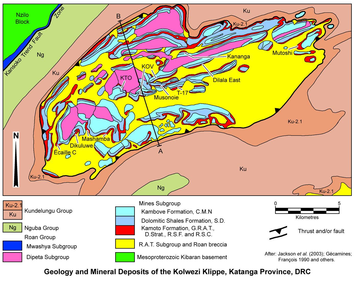
The Kolwezi Klippe covers an ENE-WSW elongated elliptical area of some 23 x 8 km, centred on the town of Kolwezi, ~250 km WNW of Lubumbashi, in Katanga Province of the Democratic Republic of Congo (DRC). It is near the northwestern margin of the ~350 km long Congolese Copperbelt, section of the larger Central African Copperbelt that extends south into Zambia. This structure hosts more than 20 sediment-hosted copper-cobalt deposits, including Écaille C, DIMA (Dikuluwe, Mashamba West & Mashamba East), KTO (Kamoto underground), KOV (Kamoto-Oliveira-Virgule), Musonoie, T-17, Dilala East, Kananga and Mutoshi (#Location: 10° 43' 19"S, 25° 24' 07"E).
These deposits constitute the largest cluster within the DRC, containing almost half of the known Roan Group hosted Cu-Co resources in the Congolese Copperbelt (Hitzman et al., 2005). They have been exploited by a number of open pits and one major underground operation (Kamoto). The majority of material mined to 2012 had been supergene enriched, containing malachite, copper and cobalt oxides, and relatively abundant chalcocite.
Regional Setting
For details of the regional setting of the Kolwezi district, the Central African/Congolese Copper Belt and the Lufilian Arc, see the Central African Copperbelt - Congolese/Katangan Copperbelt record.
Geology
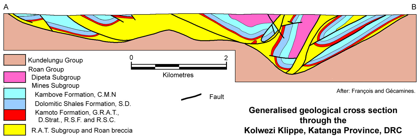
The Kolwezi Klippe is an erosional remnant of what is thought to have been an extensive northward-directed thrust sheet, emplaced in the northwestern part of the Congolese Copperbelt (François 1974). It is composed of fault dislocated blocks of Roan Group rocks, in a thrust stacked complex of isoclinal synforms and antiforms (François 1973, 1974). The base of the klippe is a shallow, undulating, inwardly dipping décollement/thrust forming a shallow syncline, structurally separating the disrupted Roan Group rocks, from underlying, poorly deformed, younger sedimentary rocks of the Kundelungu Group. The ore deposits are hosted by elongated blocks of the Roan Group rocks within a megabreccia above the décollement.
The stratigraphy of the Katanga Supergroup and the host Roan Group sedimentary rocks within the Congolese Copperbelt is described in the Congolese Copperbelt record.
Within the Kolwezi Klippe, the immediate host sequence to mineralisation is, from the footwall upward (after: Jobin-Bevans et al., 2006; Dixon et al., 2009; and references cited in both reports):
Roches Argilo-Talqueuses (R.A.T.) Subgroup (R-1),
* R.A.T. Rouge/Lilas, 0 to 235 m thick, composed of massive or irregularly stratified hematitic, reddish to lilac, chloritic (Mg chlorite), argillaceous and dolomitic siltstones, metapelites, some fine-grained sandstones and a single dolostone bed. The R.A.T. Rouge/Lilas is characterised by the absence of sulphides and its uniformly red colour, due to ubiquitous disseminated hematite. Detrital quartz, micas and chlorite are abundant in most bands, but some dolomite is always present (Bartholomé et al., 1971). Coarse banding is evident, but laminations are unusual. The upper parts of the unit are commonly represented by the R.A.T. Breccia, a reddish-pink brecciated rock with calcite and silica veinlets, and at times, well developed veinlets of specular hematite. The distribution of the R.A.T. Rouge/Lilas, and the R.A.T. Breccia in particular, implies that, in part, it is not strictly a stratigraphic, but is more likely a tectonic unit. In places it is a conformable, but in others is markedly transgressive as bands of a few metres to tens of metres wide cutting the overlying Mines Subgroup lithologies at right angles. The red R.A.T. Rouge/Lilas is overlain by the grey R.A.T. Grises with a transitional contact, which is interpreted to be an evaporitic horizon that is poorly preserved, and acted as a décollement surface for nappe emplacement during the Lufilian thrusting (Kampunzu and Cailteux, 1999).
* R.A.T. Grises, 0.5 to 2 m thick, composed of grey, chloritic and dolomitic silt- to sandstone, mineralogically similar in composition to the R.A.T. Rouge/Lilas, but distinguishable by its grey colour and the absence of haematite, which is replaced by sulphides (pyrite and chalcocite). It is basically an unstratified sandstone, with an average 0.3 mm grain size of dominantly angular quartz. Other constituents, mainly as matrix, are entirely phyllitic and most likely due to in situ alteration, including finely disseminated dolomite, talc and Mg chlorite, but no magnesite (which is abundant in the overlying member). The matrix quartz and chlorite are predominantly authigenic (Bartholomé et al., 1971). This unit is variously regarded as either the uppermost or lowermost member of the R.A.T. or Mines subgroups respectively.
Bartholomé et al. (1974) note that the upper contact of the R.A.T. Subgroup is mostly tectonic, marked by R.A.T. Breccia. However, locally, stratigraphic contacts have been observed at Kamoto, which suggest the Mines Subgroup was deposited on an erosional surface, illustrated by the truncation of veins in the R.A.T. Subgroup at the contact, and the presence of rounded pebbles of R.A.T. Subgroup in a conglomerate in the D.Strat. unit of the immediately overlying Mines Subgroup rocks.
Mines Subgroup (R-2),
Kamoto Formation (R-2.1),
* Dolomies Stratified (D.Strat.) and Roches Siliceuses Feuilletees (R.S.F.), which together form a consistent 7 to 9 m thick package throughout the Kolwezi Klippe, composed of finely laminated dolomitic siliciclastic rocks that overlie the R.A.T. Grises. The D.Strat. contains variable amounts of magnesite, occurring as laminae, thin beds and nodules, whilst authigenic quartz increases upward into the R.S.F. The D.Strat. includes a layer of 1 to 5 cm diameter nodules composed of dolomite, chert and sulphide, throughout the klippe. The host rock bedding wraps around the nodules, both above and below, and they are interpreted to represent former anhydrite clusters (Bartholomé et al., 1971). The R.S.F., which gradationally overlies the D.Strat., is composed of grey to light brown, thinly bedded, laminated and highly silicified dolostones. Together the R.A.T. Grises, D.Strat. and R.S.F. are the host to a Lower Orebody (the Orebody Inferieure; OBI), which is mineralised to variable degrees across the Klippe.
* Roches Siliceuses Cellulaires (R.S.C.), 10 to 25 m thick, which overlies the R.S.F. with a sharp contact, and at surface is a cellular siliceous rock with abundant cavities. Below the level of weathering and oxidation, it is a coarsely crystalline, massive, heterogeneous, silicified dolomitic unit, composed almost exclusively of dolomite and authigenic quartz (Bartholomé et al., 1971). The silicification is more intense along fractures, enclosing less altered dolomite which weathers to leave the honeycomb of silica and vugs seen at the surface. Remnants of stromatolitic (Collenia) structures (Bartholomé et al., 1971) have been observed, although most of the rock has been intensely recrystallised. It is un-laminated, in contrast to the over- and underlying mineralised units. With the exception of crystals of carrollite (Co2CuS4) found in the basal metre, the R.S.C. is largely devoid of sulphides and of carbonaceous material. However, within the weathered zone, the honey-combed vugs may be filled by supergene malachite to produce high grade ore. The R.S.C. also has an abrupt upper contact with the overlying unit.
Dolomitic Shales Formation (R-2.2),
* Schistes Dolomitiques (S.D.), 30 to 100 m thick, which is basically a dolomitic shale unit, mostly composed of alternating laminated, locally carbonaceous, dolomitic mudstone and siltstone beds. Disseminated microscopic pyrite is present in most of the unit, which may be accompanied by weak chalcopyrite (Bartholomé et al., 1971). The basal member is a 10 to 15 m thick grey dolomitic siltstone (Schistes De Base; SDB or SD-1a) which hosts the bulk of the Upper Orebody (the Orebody Superieure; OBS), overlain by the the Black Ore Mining Zone (BOMZ; SD-1b) which may also contain ore. The lower section of the SDB contains 1 to 5 cm diameter nodules composed of dolomite, quartz, sulphides and chlorite, similar to those in the D.Strat. Although the remainder of the overlying SD, the Shales Dolomitiques Superieure (SDS) has a number of facies variants, in the south of the klippe it is represented by a threefold repetition of grey to grey-green dolomitic siltstone, overlain by dark grey or black carbonaceous shale. Progressively to the north, dolostones and then feldspathic sandstones appear interbedded with the siltstones.
Kambove Formation (R-2.3),
* Calcaire á Minerai Noir (C.M.N.), ~130 m thick, a slightly banded and laminated light grey to grey silicified dolostone, mineralised with black oxides
of iron, manganese and cobalt, occasionally with some similarities to the R.S.C.
Dipeta Subgroup (R-3),
* Roches Gréso-Schisteuses Formation (R.G.S.) (R-3.1), 100 to 200 m of greyish to dark red or brown stratified shales and micaceous schist. This is the uppermost exposed unit within the klippe.
The topography above the Kolwezi Klippe is largely flat plains, covered by overburden, deep soil and vegetation. Unlike most other mineralised districts in the Congolese Copperbelt, the mineralised R-2 units are not expressed as ridges, and no geological structures can be identified by topographic features. Instead, the rocks of the Roan Group sub-outcrop below a thick sequence of overburden, and are immediately overlain by fine to coarse-grained saprolite which in turn is capped by a pisolitic iron crust (Dixon et al., 2007; Dewaele et al., 2006).
 Structure
The Kolwezi Klippe is one of several klippen that are interpreted to be erosional relicts of a large, folded allochthonous sheet along the northwestern margin of the Congolese Copperbelt, adjacent to the Mesoproterozoic Nzilo basement block (Demesmaeker et al., 1963; François, 1973; Jackson et al., 2003).
The ore deposits of the klippe are hosted within Mines Subgroup (R-2) rocks, above a shallow, undulating, synclinal shaped, inwardly dipping, décollement, marked by a basal zone of breccia (François, 1992). This structure defines the ENE-WSW elongated, elliptical, 23 x 8 km Kolwezi Klippe, and separates a megabreccia of R.A.T., Mines and Dipeta subgroup rocks, from the structurally underlying, but younger, sedimentary rocks of the Kundelungu Group, specifically the Mongwe Formation (Ku-2.1) dolomitic pelites, sandstones and siltstones (Dixon et al., 2009). The Mongwe Formation is conformably underlain by the remainder of the Kundelungu and Nguba groups, with lithological boundaries concentrically surrounding and mimicking the margin of the Klippe, with the décollement paralleling the Kundelungu Group stratification. The allochthonous Klippe was emplaced during the Kolwezian event, an early phase of the ~590 to 500 Ma Lufilian orogeny, prior to deformation of the Kundelungu and Nguba groups. The allochthonous sheet was subsequently folded with the Kundelungu and Nguba groups later in the Lufilian orogeny (Porada and Berhorst, 2000; Hitzman et al., 2012).
The décollement surface dips more steeply from the north, reaching its deepest point, along the keel of the synclinal structure, at a depth of ~1400 m, <3 km south of the northern margin of the klippe. From there, the gently folded undulating structure has an overall shallow south dip (although steeper near the synclinal keel) over an interval of ~5 km to the southern margin of the klippe (François, 1992).
The megabreccia above the décollement is composed of a jumble of blocks or écailles (French for 'fish-scales', a local structural term for tabular tectonic megabreccia blocks) of Mines Subgroup rocks that are up to 250 m thick and several hundred metres to 2 km in width and length, encased within a matrix of R.A.T. Subgroup blocks, R.A.T. Breccia (described above) and Breche Heterogene. The Breche Heterogene is composed of angular and sometimes well rounded rock fragments of all the various rock types of the Roan Group, that vary from finer-grained sandy particles to fragments from a few millimetres to several centimetres or more in diameter. A core of slightly less disrupted Dipeta Subgroup rocks are found in the hanging wall of the main Mines Subgroup écailles, either attached or semi-detached, mainly in the core of the main syncline.
Most Mines Subgroup écailles are gently dipping monoclines or limbs of recumbent tight to isoclinal synclines and anticlines that have been dislocated by axial plane parallel thrusts through their closures. The individual écailles are usually limbs of faulted isoclinal folds, and are relatively tabular, largely only disrupted by brittle faulting perpendicular to bedding, which has been invaded by breccia. Across the axis of the Kolwezi Klippe syncline, there is a general symmetry of inward-dipping and dismembered folded écailles, although in the core of the syncline, these blocks are steep to overturned. On the southern side of the main klippe syncline axis, the north-dipping écailles mirror the steeper southern dips to the north of the axis. However, these dips and the complexity of deformation progressively decreases to the south (François, 1973).
The écailles are bounded by faults or relatively abrupt transitions to breccia matrix, and may be imbricated and juxtaposed across faults, or separated by breccia matrix, subparallel, or at a high angle to neighbouring blocks, e.g., in the KOV cluster of écailles as described below. All contain the same sequence and both Upper and Lower orebodies (Dixon et al., 2007).
 Deposits
DIMA - Dikuluwe, Mashamba West and Mashamba East, which were mined in three contiguous pits that are distributed over an east-west interval, but are temporally separate, exploiting a semicontinuous string of deposits with similar geology and mineralisation styles. Ore occurs within both the Upper and Lower orebodies of the Kamoto and Dolomitic Shales formations, separated by 10 to 12 m of sub-economic supergene mineralised R.S.C. The contact between the R.A.T. Rouge/Lilas and overlying host Mines Subgroup is a glide fault. These deposits are characterised by two main structures, a shallowly northward plunging syncline forming the western limit of the known deposit (in the north-south elongated Dikuluwe pit), and a northward plunging anticline that forms the central portion of the deposit in the Mashamba West and East pits. At Mashamba East, the lithologies of the orebody strike to the NNE, dipping gently to the north in the west, and wrap around to strike almost north-south and dip to the east in the eastern portion of the pit. Initial mining in the Mashamba West pit was concentrated in the apex of the anticlinal structure. Transverse and longitudinal faults cutting the deposits are prevalent along the apexes and troughs of the folds. Thrust and low angle faults are related to the intense folding that led to the formation of the écailles. Dips vary from flat, to locally steep (Jobin-Bevans et al., 2006). The Mashamba East Mine operated from 1985 to 1988, producing 9.8 Mt @ 4.96% Cu, 0.35% Co (Dixon et al., 2009).
Écaille C - is located ~3 km SSW of the Dikuluwe pit, in an écaille on the western margin of the Kolwezi Klippe.
Kamoto - the Kamoto Mine was opened by Gecamines as 1942, with open pit mining commencing in 1948, followed by the commissioning of the Kamoto underground
shaft in 1959. Production from 1969 to 2005 was 59.4 Mt @ 4.21% Cu and 0.37% Co (Dixon et al., 2009). The Kamoto underground operations extract copper ores from the Kamoto
Principal écaille, which is differentiated from Kamoto East, mined in the KOV pit, but contains the same lithologies. Ore occurs in both the Upper and Lower orebodies. The morphology of the ore body is gently dipping at 25 to 40° on the southern and western edges, flat to gently dipping, between 0 and 20°, in the central sections, while on the eastern edge, the deposit turns nearly vertical. In the underground section of the Kamoto Mine, the deposit has been subdivided into a number of different zones with varying dips and ore-body characteristics, related to their position relative to fold axes and faulted disruptions, varying from 0 to 10°, from 30 to 60° and 60° to vertical (Jobin-Bevans et al., 2006).
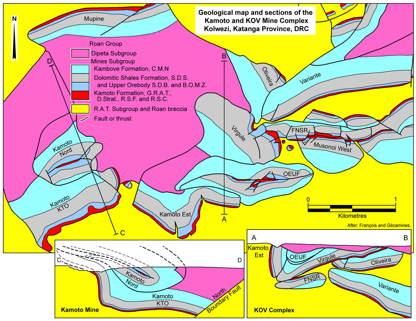 KOV - Kamoto-Oliveira-Virgule - the KOV Mine exploits four écailles, namely, Kamoto-East, Oliveira, Virgule and FNSR (a small remnant of the Musonoi West
fragment mined to the east), and is underlain by Variante. Mining commenced at the Musonoi pit in 1943 and ceased by 1984. The Kamoto East pit started in 1959 and continued operations to 1985. Ore production from the KOV pit commenced in early 1985 and carried on, at declining production rates, through to 2000. During that time, 38 Mt @ 5.8% Cu, 0.5% Co was produced. Ore occurs in both the Upper and Lower orebody positions. The KOV écailles occur in an east-west-striking syncline-like structure consisting of a steeply dipping to overturned southern limb, and a shallow dipping northern limb, respectively comprising the Kamoto East and Virgule blocks, which abut across a fault in the fold nose. The Oliveira fragment is juxtaposed across a thrust, below, and dipping parallel to, the northern half of the Virgule écaille. The Variante fragment abuts the down dip extremity of the south-dipping Oliveira fragment and the underside of the Virgule écaille, but dips north at a high angle to both (Dixon et al., 2009).
KOV - Kamoto-Oliveira-Virgule - the KOV Mine exploits four écailles, namely, Kamoto-East, Oliveira, Virgule and FNSR (a small remnant of the Musonoi West
fragment mined to the east), and is underlain by Variante. Mining commenced at the Musonoi pit in 1943 and ceased by 1984. The Kamoto East pit started in 1959 and continued operations to 1985. Ore production from the KOV pit commenced in early 1985 and carried on, at declining production rates, through to 2000. During that time, 38 Mt @ 5.8% Cu, 0.5% Co was produced. Ore occurs in both the Upper and Lower orebody positions. The KOV écailles occur in an east-west-striking syncline-like structure consisting of a steeply dipping to overturned southern limb, and a shallow dipping northern limb, respectively comprising the Kamoto East and Virgule blocks, which abut across a fault in the fold nose. The Oliveira fragment is juxtaposed across a thrust, below, and dipping parallel to, the northern half of the Virgule écaille. The Variante fragment abuts the down dip extremity of the south-dipping Oliveira fragment and the underside of the Virgule écaille, but dips north at a high angle to both (Dixon et al., 2009).
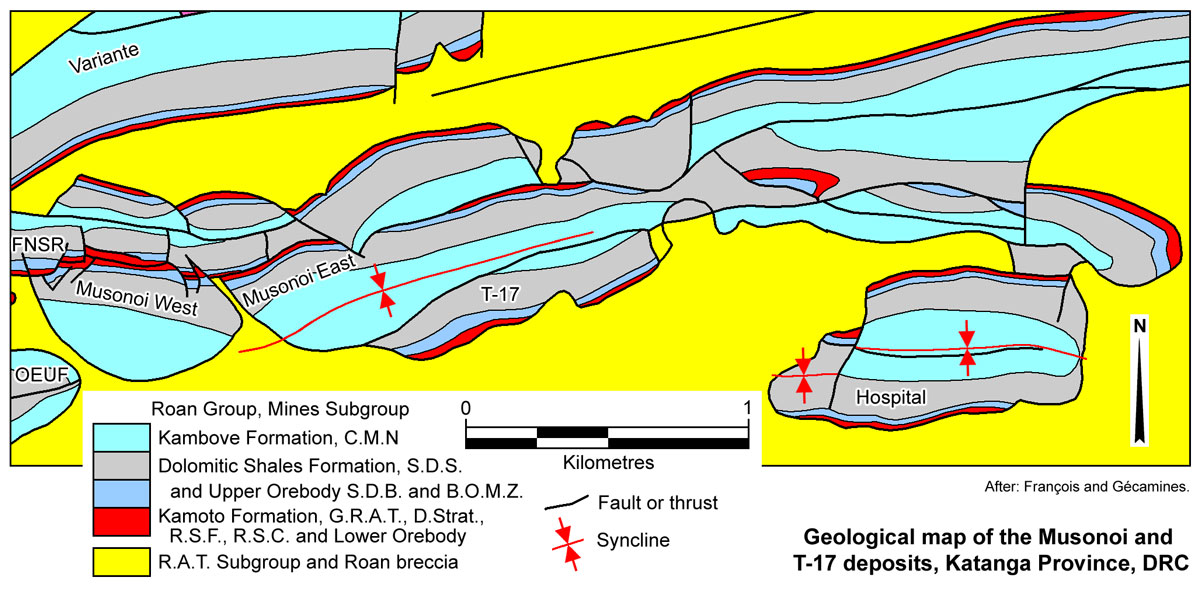
Musonoi and T-17 - pre-stripping commenced in May 2007 and the first ore was blasted in September of the same year (Dixon et al., 2009). The deposits are hosted by dismembered, structurally complex, écailles of Mines Subgroup, encased in R.A.T. metasedimentary units on both limbs of a 2.6 km synclinal fold, overturned towards the north. Faulting is predominantly responsible for dismemberment of the deposit. The Musonoi deposit strikes at 65 to 90° over a strike length of 1050 m on the northern limb, composed of two separate, west and east resources, divided by an injection of R.A.T. Breccia along a fault plane. The T-17 deposit is exposed on the southern limb of the syncline. Mineralisation is hosted in both the Upper and Lower orebodies (Jobin-Bevans et al., 2006).
 Dilala East - is hosted within the Dilala écaille, which strikes ENE over an interval of ~2500 m, and is overturned, dipping at ~60°SE. This écaille is immediatey to the south of the main synclinal core, overlain by Dipeta Subgroup rocks on its northern margin, bounded by R.A.T. Breccia to the south, and is in the eastern half of the Kolwezi Klippe. The deposit occurs on the eastern tip of the écaille and does not outcrop, as it is fault bounded on three sides, namely the western and eastern margins, as well as in the up-dip direction. The top of the deposit is at a depth of ~50 m. The bounding faults have been interpreted to be a single thrust plane, separating the well mineralised, Dilala East domain (as a separate buried fragment) from the poorly mineralised, outcropping Dilala West domain to the west. The deposit has a total strike length of 600 m, and extends down dip to >400 m below surface. The ore occurs in both the Upper and Lower orebodies, which are 12 and 14 m thick respectively, separated by 20 m of lesser mineralised R.S.C. The host rocks are overturned, dipping at 70°S. The structurally overlying Lower orebody, in the R.S.F., contains ~5% Cu, 1.1% Co, the R.S.C., ~0.7% Cu, 0.6& Co, and the Upper Orebody in the structural footwall, hosted by the S.D.B., contains ~3.5% Cu, 1.2% Co. The mineralised hosts in the weathered zone consist of talc shales, breccias and siltstones. Copper and cobalt mineralisation generally occurs as malachite and heterogenite/kolwezite in the oxide portion of the deposit, and chalcocite, bornite and carrollite in the deeper sulphide zone. The zone of oxidation generally extends to ~220 m below surface. The Dilala écaille was drilled (112 drillholes) by Union Miniere du Haut Katanga between 1938 and 1950. These holes were drilled in the western fragment of the écaille and did not intersect significant, economically viable mineralisation. No major primary mining activity has taken place on the deposit. Delineation and infill drilling of the écaille (the Musonoi Est prospect) by Ruashi Holdings/Metorex commenced in 2006 (Metorex, 2010).
Kananga - worked by contractors and artisanal miners from 2004. Kananga is on the northern limb of the Kananga-Dilala syncline, which plunges to the south. Exploration defined mineralisation over a strike length of ~600 m across Kananga Hill. The ore is predominantly oxide, mainly malachite and pseudomalachite with associated heterogenite, and with very little sulphide. The host rock is both dolomitic and siliceous.
Mutoshi - is located on the far eastern extremity of the Kolwezi Klippe, 10 km east of Kolwezi. The abandoned Mutoshi Mine started life as the Ruwe Gold Mine in 1904, producing 2 tonnes of gold with lesser amounts of platinum and palladium until 1949. The Mutoshi stratabound Cu-Co ore bodies were first drilled in the early 1920s but exploitation did not start until 1937, with the main mining commencing in the 1950s. The mine closed in 1987 following pit wall collapses.
Stratabound ore at Mutoshi occurs in the Upper and Lower Orebody positions of the Mines Subgroup, but also a third stratigraphically position within the R.A.T. Subgroup, referred to as the 'Breche Orebody'. The sandstones and dolomitic sandstones below the Mines Subgroup ore bodies are intensely brecciated and porous. Copper mineralisation from the Mines Subgroup ore bodies is interpreted to have been leached and re-deposited laterally or vertically as exotic ore within the R.A.T. breccia as malachite, in the form of interstitial grains, nodules from 1 to >10 cm in diameter, and fine to coarse veinlets and stringers. The average grade of the Breche Orebody was estimated at 1.77% Cu and the thickness in many parts exceeded 60 metres, over and area of several square kilometres.
Production for the period 1960 to 1987 was 38.97 Mt @ 1.77% Cu from the Breche Orebody comprising malachite within the R.A.T. breccia and 5.95 Mt @ 4.93% Cu and 0.3% Co from the Mines Subgroup orebodies.
From west to east, Écaille C is on the western margin of the klippe, then the DIMA (Dikuluwe, Mashamba West and Mashamba East), Kamoto (KTO), KOV and Musonoie T-17 mines, which are distributed over an WSW-ENE interval of ~11.5 km in the western half of the Klippe, while Kananga is ~6 km further to the NE to NNE, and Dilala East is NE of Musonoie T-17 and SE of Kananga. The DIMA pits are east-west aligned, over an interval of 4.5 km. A gap of ~3 km separates the DIMA pits from the combined KOV-Musonoie T-17 pit to the NE, which is elongated WSW-ENE over a length of 3.8 km. The Kamoto (KTO) underground mine headframe is midway between the two lines of pits. Dilala East is ~5 km NE of the centre of the KOV-Musonoie T-17 pit cluster and 2 km SE of Kananga. Écaille C is on the western margin of the klippe, ~3 km SSW of Dikuluwe. Mutoshi is on the eastern margin of the Kolwezi Klippe.
These deposits define a broad corridor extending across the core of the Klippe, from near its southwestern corner, to the northeastern tip. The rocks of the Mines Subgroup that are mineralised belong to the Musonoi and Kilamusembu facies, 2 of the 6 facies defined by François (1973; 1974; 2006) across the Lufilian Arc. These are in most cases the only two facies that host significant deposits within the Congolese Copperbelt. For details of these facies, their characteristics, distribution and mineralisation, see the 'Mineralised Facies within the Mines Subgroup' paragraphs of the 'Mines Subgroup Orebodies' section of the separate Congolese Copperbelt record. The northern third of the Klippe is occupied by rocks that belong to the generally unmineralised Long facies.
Mineralisation & Alteration
As detailed above, the main sediment hosted Cu-Co deposits of the Kolwezi Klippe comprise a Lower and an Upper Orebody, hosted by the Kamoto and lower Dolomitic Shales formations of the Mines Subgroup respectively, separated by a low grade silicified stromatolitic dolomite (R.S.C.). The lithology of the host rock to the Lower Orebody is an altered chloritic and dolomitic siltstone, and stratified and silicified dolostones, whereas the Upper Orebody host consists mainly of dolomitic shales, dolostones and fine-grained sandstones. In both, bedding is millimetre to centimetre scale layering, reflecting the grain-size and mineralogical variations (François, 1973). The color of the host rocks ranges from light grey to black, reflecting their high organic matter content (Cailteux 1994; Cailteux et al., 2005)
Primary Cu and Co occur as fine disseminations, layers and nodules of sulphide minerals, dominantly chalcocite and carrollite in both orebodies, with lesser bornite, accompanied by minor chalcopyrite on the upper margins of the Upper orebody. The distribution of these sulphides is largely controlled by sedimentary features, following bedding planes in the finely bedded host rocks. Late crosscutting fractures and veinlets contain dolomite, silica and chalcocite-digenite-hematite mineralisation.
El Desouky et al. (2010) distinguish the following Cu-Co sulphide mineralisation styles within these orebodies, and adjacent rocks. Within a single mineralisation style, chalcopyrite is always paragenetically the earliest and chalcocite the latest.
i). Disseminated Cu-Co sulphides - which are fine- to coarse-grained and form individual grains or groups of grains, paralleling the stratification, generally more abundant in the dolomite-rich beds than in the shaly bands. There is a consistent positive correlation between the grain size of disseminated sulphides and the host rock, with sulphides being coarse-grained in the well-crystallised coarse-grained host rock dolostone and fine-grained in the medium- to fine-grained host rock dolostone and in the shaly beds.
ii). Nodules and layers of Cu-Co sulphides with variable pyrite and a dolomite-quartz gangue, and sulphide lenses that are 1 to several mm thick, with no associated gangue minerals. Two types of nodules and layers are evident,
* Type I - an early lenticular to elliptical variety, which are thin, and discontinuous, with long axes parallel to the stratification, and irregular margins with the host rock. These nodules and layers, which appear to have originated as pre-compaction features, are characterised by typically anhedral and fine-grained crystals of Cu-Co sulphides and gangue minerals (mainly dolomite and quartz). These nodules and layers are interpreted to be pseudomorphs after anhydrite/gypsum (Cailteux 1994; Muchez et al., 2008), on which dolomite was precipitated first, and subsequently replaced by Cu-Co sulphides and authigenic quartz. Similar magnesite nodules and lenses in the D.Strat. unit, one of the hosts to the Lower Orebody, are probably related.
* Type II - later, circular or subrounded nodules, not necessarily parallel to the stratification, and layers that are parallel to stratification, but in rare cases cut and displace oblique veins. These second style nodules and layers have sharp boundaries with the host rock. Type II nodules and layers, as well as the veins, and breccia cements described below, are all composed of subhedral to euhedral coarse-grained, free-growing Cu-Co sulphides, quartz and dolomite, in which quartz and Cu-Co sulphides were precipitated first and overgrown and replaced by dolomite.
iii). Sulphides in veins, which are millimetres to decimetres thick, and occur as straight individual veins or vein swarms with similar composition that branch
and crosscut each other, suggesting several vein generations. These veins cut type I layers and nodules, but may be coeval, at least on part, with the type II lenses and nodules.
iv). Sulphides in tectonic breccia cement, which enclose small, mm- to cm-size, fragments that are rounded to angular and have a dolomitic and/or shaly composition.
The following paragenetic sequence of alteration and mineralisation has been determined for the Kamoto and Musonoi deposits by Dewaele et al. (2006):
The primary components of the Mines Subgroup rocks were carbonate, quartz, detrital muscovite and minor detrital chlorite and tourmaline, deposited by direct clastic sedimentation.
Nodules of anhydrite and gypsum were formed in the evaporitic environment, accompanied by an early diagenetic dolomitisation that partly replaced the evaporate nodules or was precipitated in dissolution cavities. Laminae, thin beds and nodules of magnesite, most likely after evaporites, are also common throughout the D.Strat. of the Lower Orebody (Bartholomé et al., 1974).
Framboidal and euhedral pyrite were formed in the subsurface during early diagenesis, soon after deposition and predate the main copper mineralisation.
The early pyrite is overgrown and partly replaced by chalcopyrite, although both of these minerals are only preserved in the upper margins of the Upper Orebody where replacement by later sulphides is incomplete. El Desouky et al. (2010) note that pyrite and lesser chalcopyrite occurs in the stratigraphic units hosting the Lower and Upper Orebodies, but only when these units are barren or poorly mineralised. Bartholomé et al. (1974) note that early diagenetic pyrite in the S.D. unit, above the Upper Orebody, has closely associated titanium oxide minerals, interpreted to represent a transformation/sulphidation of detrital ilmenite (i.e., FeTiO3 + S → FeS2 + TiO2). The same titanium oxide products are also found in association with Cu sulphides in the Upper Orebody.
Authigenic quartz, which is younger than the early diagenetic dolomite, was precipitated in the host rocks to the Lower and Upper orebodies and the low-grade intervening R.S.C. This quartz is intimately associated with the main phase of sulphide precipitation, comprising carrollite, bornite, digenite and chalcocite. This more intense sulphide phase largely obliterated the earlier pyrite and chalcopyrite, except on the upper, more distal fringes of the Upper Orebody and laterally beyond the ore zone, and as rare relicts of earlier chalcopyrite within the main ore zones. Microthermometry of fluid inclusions in the authigenic quartz indicate fluids with a minimum temperature between 80 and 195°C and a salinity between 8.4 and 18.4 wt.% NaCl equiv.
The main sulphide mineralisation phase and authigenic quartz was followed by a second dolomite generation that included some recrystallisation of early dolomite. Digenite and corroded chalcocite grains occur with this second dolomite cement which shows growth zoning.
A third, coarsely crystalline dolomite cement was then deposited, together with chalcocite, digenite and hematite in fractures and concentrated in spots or irregular layers. The hematite is an alteration product of sulphide formation, i.e., when additional Cu is added to higher Fe sulphides (e.g., pyrite, chalcopyrite or bornite) from oxidised brines to form Fe-poor to Fe-free sulphides (e.g., bornite, chalcocite or digenite), the excess Fe is released as an oxide.
A fourth intensely zoned dolomite generation overprints the third dolomite. The fractures/veins filled with the two last dolomite generations and the associated chalcocite-digenite-hematite mineralisation crosscut the compacted rock with the stratabound carrollite-bornite-chalcocite-digenite mineralisation. Unlike at Tenke-Fungurume, these veins do not contribute substantially to the grade of the hypogene ores.
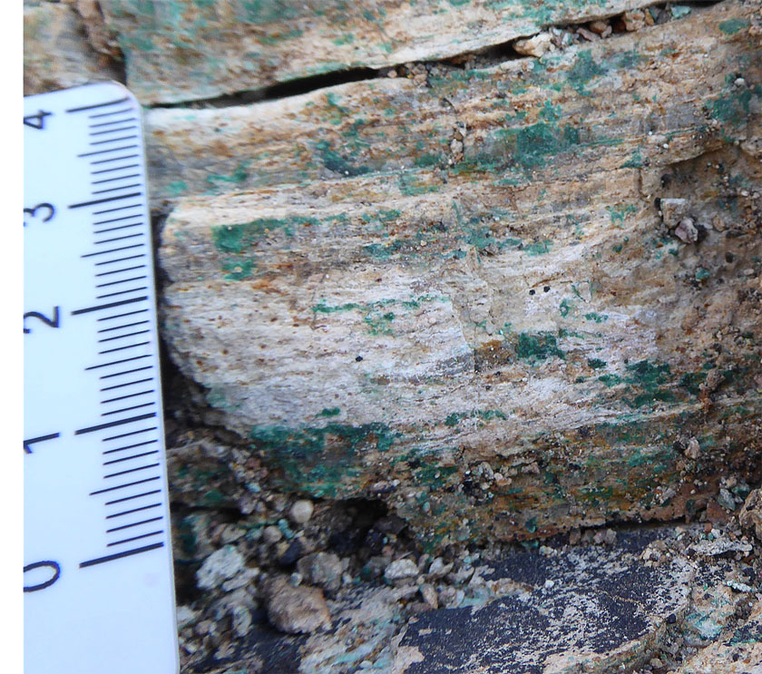
KOV mineralisation - high grade supergene oxide ore of the Lower Orebody hosted by the laminated, silicified, algal dolomite of the Mines Subgroup R.S.F unit. Scale card graduated in millimetres. Photograph by Mike Porter, 2014.
Supergene Mineralisation
The bulk of the Cu-Co ore mined from the Kolwezi Klippe has been supergene oxide and sulphide ore. Supergene mineralisation is generally associated with subsurface oxidation of both the Upper and Lower orebodies, sometimes to >100 m below surface, and is particularly prevalent in the DIMA pits area and the upper parts of the Musonoie T-17 West deposit. The secondary minerals often fill vugs and cavities in carbonate-rich units, and in addition to the two main orebody positions, may migrate into the hanging and footwalls of the two orebodies. The normally barren, cellular R.S.C. unit, which separates the two orebodies, often occurs as a cellular siliceous rock from which the dolomite component has been leached to form a honey-combed texture, where the vugs have been filled by malachite and the supergene cobalt hydroxide, heterogenite, particularly near surface (Dixon et al., 2009; Jobin-Bevans et al., 2006). In some areas, e.g., Musonoie T-17, the supergene ore is overlain by a leached cap where the mineralisation has been totally leached in the upper 25 m below the surface (Katekesha, 1989). Supergene enrichment has resulted in a major upgrading of the copper content (from a few percent, locally up to 25% Cu; Dewaele et al., 2006).
The hypogene sulphide minerals have been altered to supergene carbonates, silicates and phosphates. The most common secondary copper mineral is malachite [Cu2CO3(OH)2], with lesser cuprite [Cu2O], cornetite [Cu3(PO4)(OH)3], libethenite [Cu2OH)PO4] and pseudomalachite [Cu5(PO4)2(OH)4.H2O]. Small amounts of copper silicates, e.g., chrysocolla [CuSiO3.nH2O] and copper carbonates, e.g., azurite [Cu3(OH)2(CO3)2] are also encountered. Heterogenite [(Co,Cu,Mn,Fe)O(OH)] and kolwezite [(Cu,Co)2(CO3)(OH)2] are the principal secondary cobalt minerals, with some goethite. The supergene Cu-Co assemblage is underlain by secondary chalcocite, overprinting the primary chalcocite, which are hard to differentiate (Dixon et al., 2009).
Estimated total production + 'reserves' in the Kolwezi District at 2012 (Hitzman et al., 2012, after Woodhead 2012, unpublished):
726 Mt @ 4.48% Cu, 0.33% Co.
Published JORC compliant ore reserves and mineral resources at December 31, 2011 (van der Schyff, March, 2012, Technical Report prepared for Katanga Mining Ltd) at a nil cut-off, and quoting total Cu and total Co, were:
Measured + indicated resources
KTO - 65.0 Mt @ 4.21% Cu, 0.57% Co;
Mashamba East - 75.0 Mt @ 1.80% Cu, 0.38% Co;
T-17 - 13.9 Mt @ 3.88% Cu, 0.61% Co;
KOV - 121.1 Mt @ 5.37% Cu, 0.41% Co;
Kananga - 4.1 Mt @ 1.61% Cu, 0.79% Co;
TOTAL measured + indicated resource - 279.1 Mt @ 4.07% Cu, 0.46% Co;
Inferred resources
KTO - 11.0 Mt @ 5.00% Cu, 0.59% Co;
Mashamba East - 65.3 Mt @ 0.76% Cu, 0.10% Co;
T-17 - 5.2 Mt @ 4.21% Cu, 0.98% Co;
KOV - 69.8 Mt @ 3.58% Cu, 0.32% Co;
Kananga - 4.0 Mt @ 2.00% Cu, 0.98% Co;
TOTAL inferred resource - 155.3 Mt @ 2.48% Cu, 0.28% Co;
Proved + probable reserves - included within resources
KTO (Kamoto underground) - 32.4 Mt @ 3.59% Cu, 0.52% Co;
Mashamba East (open pit) - 5.9 Mt @ 3.00% Cu, 0.36% Co;
T-17 (underground) - 0.9 Mt @ 3.51% Cu, 0.57% Co;
T-17 (open pit) - 1.6 Mt @ 3.52% Cu, 0.56% Co;
KOV (open pit) - 55.1 Mt @ 4.74% Cu, 0.45% Co;
TOTAL proved + probable reserves - 96.0 Mt @ 4.21% Cu, 0.47% Co.
Published SAMREC compliant mineral resources for the Dilala East deposit were:
Measured + indicated + inferred resources, at 31 December 2009, at a 2.5% Cu equiv. cut-off (Metorex Technical Report, 2010)
total oxides - 5.2 Mt @ 3.0% Cu, 0.93% Co;
total sulphides - 13.9 Mt @ 2.9% Cu, 0.87% Co;
TOTAL measured + indicated + inferred resources - 19.1 Mt @ 2.9% Cu, 0.89% Co;
Declared resource in 2013 (Metorex website, 2013)
TOTAL resources - 22.5 Mt @ 3.3% Cu, 0.9% Co.
Published JORC compliant mineral resources at Écaille C in September, 2009 (report by African Mining Consultants) at a 0.5% Acid sol. Cu cut-off were:
Measured + indicated resource - 316.028 Mt @ 1.44% Total Cu, 1.28% Acid sol. Cu, 0.12% Total Co;
Inferred resource - 25.147 Mt @ 1.24% Total Cu, 1.04% Acid sol. Cu, 0.07% Total Co;
TOTAL resources - 341.175 Mt @ 1.42% Total Cu, 1.26% Acid sol. Cu, 0.12% Total Co.
Estimated production + resources Wilson, et al., USGS, (2010) at the Mutoshi deposit, was:
Mutoshi (Mines Subgroup, stratabound ore) - 10.765 Mt @ 4.20% Cu 0.30% Co;
Mutoshi (breccia malachite ore) - 45.460 Mt @ 1.75% Cu;
Mutoshi Northwest 10 Mt @ 4% Cu.
Information in this summary has in part been taken from Jobin-Bevans et al., June 2006, "Technical report for Kamoto Copper Company Kolwezi, Katanga Province, Democratic Republic of the Congo", prepared for Katanga Mining Limited; and updated versions with varying titles by Dixon et al., March 2007 and March 2009; and van der Schyff, March, 2012 -and- Metorex Limited staff, March, 2012, "Competent persons' report (CPR) and valuation of the Metorex growth projects in the Democratic Republic of the Congo".
The most recent source geological information used to prepare this decription was dated: 2012.
Record last updated: 1/11/2013
This description is a summary from published sources, the chief of which are listed below.
© Copyright Porter GeoConsultancy Pty Ltd. Unauthorised copying, reproduction, storage or dissemination prohibited.
|
|
|
|
|
Dewaele, S., Muchez, Ph., Vets, J., Fernandez-Alonzo, M. and Tack. L., 2006 - Multiphase origin of the Cu-Co ore deposits in the western part of the Lufilian fold-and-thrust belt, Katanga (Democratic Republic of Congo) : in J. of African Earth Sciences v.46, pp. 455-469.
|
El Desouky H A, Muchez P, Boyce A J, Schneider J, Cailteux J L H, Dewaele S and von Quadt A, 2010 - Genesis of sediment-hosted stratiform copper-cobalt mineralization at Luiswishi and Kamoto, Katanga Copperbelt (Democratic Republic of Congo): in Mineralium Deposita v.45 pp. 735-763
|
Haynes D W 1986 - Stratiform Copper deposits hosted by low-energy sediments: II. Nature of source rocks and composition of metal-transporting water: in Econ. Geol. v81 pp 266-280
|
Haynes D W 1986 - Stratiform Copper deposits hosted by low-energy sediments: I. Timing of Sulfide precipitation - an hypothesis: in Econ. Geol. v81 pp 250-265
|
Hitzman, M.W., Broughton, D., Selley, D., Woodhead, J., Wood, D. and Bull, S., 2012 - The Central African Copperbelt: Diverse Stratigraphic, Structural, and Temporal Settings in the Worlds Largest Sedimentary Copper District: in Hedenquist, J.W., Harris, M. and Camus, F., 2012 Geology and Genesis of Major Copper Deposits and Districts of the World - A tribute to Richard H Sillitoe Society of Economic Geologists Special Publication 16, pp. 487-514.
|
Muchez, P., Andre-Mayer, A-S., El Desouky, H.A. and Reisberg, L., 2015 - Diagenetic origin of the stratiform Cu�Co deposit at Kamoto in the Central African Copperbelt: in Mineralium Deposita v.50 pp 437-447
|
Van Wilderode J, El Desouky H A, Elburg M A, Vanhaecke F and Muchez P, 2014 - Metal sources for the Katanga Copperbelt deposits (DRC): insights from Sr and Nd isotope ratios: in Geologica Belgica v.17 pp. 137-147
|
|
Porter GeoConsultancy Pty Ltd (PorterGeo) provides access to this database at no charge. It is largely based on scientific papers and reports in the public domain, and was current when the sources consulted were published. While PorterGeo endeavour to ensure the information was accurate at the time of compilation and subsequent updating, PorterGeo, its employees and servants: i). do not warrant, or make any representation regarding the use, or results of the use of the information contained herein as to its correctness, accuracy, currency, or otherwise; and ii). expressly disclaim all liability or responsibility to any person using the information or conclusions contained herein.
|
Top | Search Again | PGC Home | Terms & Conditions
|
|


