|
Central African Copperbelt - Congolese/Katangan Copper Belt |
|
|
Katanga, Dem. Rep. Congo |
| Main commodities:
Cu Co
|
|
 |
|
|
 |
Super Porphyry Cu and Au


|
IOCG Deposits - 70 papers
|
All papers now Open Access.
Available as Full Text for direct download or on request. |
|
|
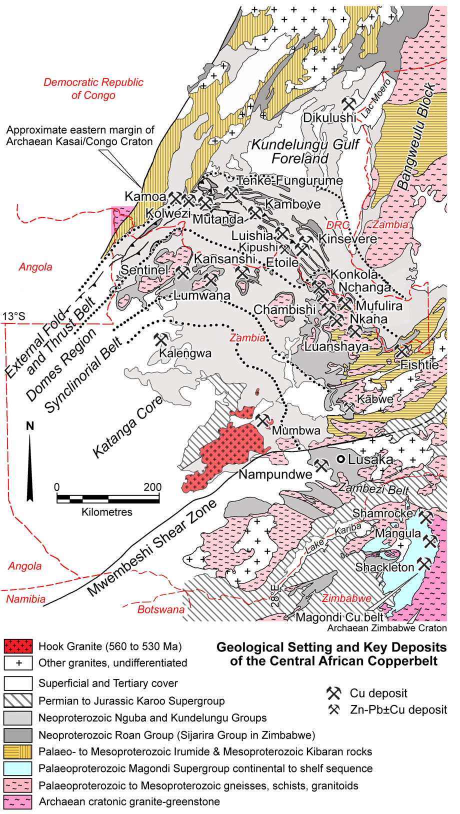
The Congolese (or Katangan) Copperbelt, extends over an arcuate interval of ~300 km in Katanga Province of the Democratic Republic of Congo (DRC). It is part of the larger, >400 km long Central African Copperbelt, that continues south into neighbouring Zambia, to become the Zambian Copperbelt.
Although part of the same curvilinear trend, the Congolese Copperbelt is hosted by carbonate-rich rocks deposited in an evaporitic environment, in contrast to the Zambian Copperbelt deposits, which are hosted by non-evaporitic, rift facies siliciclastic rocks, which are not temporally or lithologically equivalent to the hosts in the DRC.
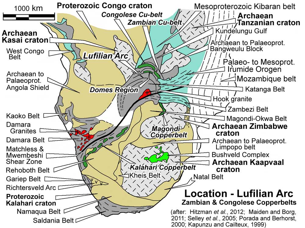
In the DRC, major Cu-Co mineralisation is hosted by Neoproterozoic metasedimentary rocks of the Katangan Supergroup, closely coinciding with the external fold and thrust belt of a complex, arcuate structural zone, the Lufilian Arc, which trends from east-west, to the west, to NW-SE to in the SE. This arcuate structure is developed normal to, and near the northeastern extremity of the elongate, 2000 km long, NE-SW trending, Damaran-Katangan belt of Meso- to Neoproterozoic sedimentary basins that extends across the continent to the Atlantic Ocean in the SW (see location map below).
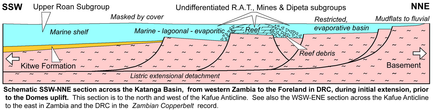
The Katangan Supergroup sequence commences with the Roan Group, composed of an early, oxidised, mainly clastic, rift phase, including the Lower Roan Subgroup, deposited in a number of connected intracontinental rift basins in Zambia. The rift-stage rocks were overlain by a thermal sag phase sequence of largely reduced, mixed evaporitic carbonate and finer clastic rocks of the Upper Roan Subgroup in Zambia. The same sag phase sequence spread north onto basement in the DRC, where the preserved basal R.A.T. Subgroup unit is interpreted to represent the residue following later dissolution of a thick salt/evaporite unit, overlain by largely reduced, transgressive, mixed evaporitic carbonate and finer clastic rocks enclosing a number of regressive phases, which together constitute the Mines and Dipeta Subgroups. These successions were deposited between 880 and 750 Ma
A succeeding renewed rift stage expanded and deepened the basin and produced the more extensive, mainly fine, reduced, clastic sequence, accompanied by mafic intrusion and volcanism of the Mwashya Subgroup, the uppermost unit of the Roan Group. These were overlain by the widespread glacial (Sturtian) and post-glacial deposits of the Nguba Group from ~750 to ~630 Ma and similar rocks of Kundelungu Group to ~560 Ma. The overlying non-evaporitic, molassic, clastic (with lesser carbonate) rocks that make up the remainder of the latter group, accompanied basin inversion during the ~590 to 500 Ma Pan-African Lufilian orogeny.
Significant, stratabound, sediment hosted copper and/or cobalt deposits in the DRC are found within the: lower Mines Subgroup (e.g., the Kolwezi Klippe and Tenke-Fungurume clusters, each with >500 Mt @ >3.5% Cu, >0.3% Co); lower and middle Mines Subgroup (e.g., Kinsevere with >50 Mt @ >3% Cu); upper Dipeta Subgroup (e.g., the Mutanda and Deziwa deposits, each with >300 Mt @ >1.4% Cu, 0.12 to 0.6% Co); and Mwashya and basal Nguba Group (e.g., Kamoa with >750 Mt @ >2.6% Cu).
These groupings of deposits within different host age rocks are spatially zoned within the Lufilian Arc, controlled by basin architecture, structure and facies, with ore usually hosted by the first reduced package above a predominantly oxidised underlying sequence.
Regional Setting
The ~500 km long Lufilian Arc is a structural element imposed upon the rocks of the Katangan fold belt in western Zambia and southern DRC during the ~600 to 510 Ma Lufilian Orogeny. The Katangan fold belt contains the Neoproterozoic, ~880 to ~530 Ma Katangan Supergroup succession, separating and lapping onto the Kalahari and Congo cratons of central and southern Africa respectively. It is one of a number of similar Pan-African fold belts (West Congo, Kaoko, Gariep, Damaran, Katangan and Zambezi) that fringe and/or separate these two cratons, and which may be interconnected below intervening Phanerozoic cover. The Kalahari and Congo cratons are composites of earlier Archaean nuclei (e.g., the Kaapvaal and Zimbabwe cratons within the former) and Palaeo- to Mesoproterozoic elements that were amalgamated and cratonised by ~1.05 Ga as part of the Rodinia supercontinent.
The oldest basement rocks exposed as inliers within, and marginal to the Lufilian Arc, comprise a Palaeoproterozoic, Eburnian-Ubendian (~2.05 to 1.85 Ga) calc-alkaline magmatic arc sequence of metasedimentary, metavolcanic and intrusive granitoid rocks of the Lufubu Metamorphic Complex, part of a larger north-south to northwest-trending Ubendian magmatic arc, mainly underlying the Lufilian Arc in the east, particularly in the Kafue Anticline and Bangweulu Block (Rainaud et al., 2005; Selley et al., 2005; Petters, 1986).
The Archaean to early Palaeoproterozoic basement rocks of the Kalahari and Congo craton are separated from the Neoproterozoic sequence of the Lufilian Arc by the Mesoproterozoic Kibaran and Irumide successions respectively. These rocks represent the extensive, generally northeast-trending, Kibaran-Irumide mobile belt, comprising thick (>10 km) sequences of variously metamorphosed, post 1.4 Ga, rift-setting, conglomerates, sandstones, shales with lesser dolerite flows, and overlying graphitic shales, stromatolitic limestones and dolostones. Two main styles of granitoid intrusion are recognised, the ~1.3 to 1.25 syn-orogenic gneissic to un-metamorphosed granitoids which accompanied compression and basin inversion, and 1.2 to 0.95 Ga post-orogenic alkaline varieties (Petters, 1986 and sources quoted therein).
For a more detailed description of the basement sequence, see the Zambian Copperbelt record.
In the Congolese Copperbelt, an ~200 m.y. period of tectonic quiescence followed the assembly of Rodinia, before extension and Neoproterozoic sedimentation heralded the commencement of its breakup.
To the south in the Zambian section of the Lufilian Arc, the resultant 4 to 10 km thick, Katanga Supergroup (~880 to ~600 Ma) included an initial sequence of coarse grained, fluvial conglomerates and sandstones, dominantly siliciclastics, devoid of volcanic activity, within relatively restricted, fault controlled intracontinental rift basins, represented by the Mindola Clastics Formation. These depositional centres were subsequently linked along master faults, marking a transgression, with the deposition of local finer facies, including the Copperbelt Orebody Member (a finely laminated, variably organic rich dolomitic siltstone, including lesser carbonaceous shale, argillaceous sandstone, and laminated, microbial dolostone, averaging 20 to 25 m thick). The Copperbelt Orebody Member is the basal unit of the Kitwe Formation, which comprises coarse and fine siliciclastic sedimentary rocks, representing fluctuating emergent and subaqueous conditions. This package of Mindola Clastics and Kitwe formation rocks, which rests unconformably on older basement, comprises the Lower Roan Subgroup in Zambia, the lowest member of the Roan Group. In the DRC, this sequence is only recognised on the northern flanks of the Luina Dome where it rests on Palaeoproterozoic basement.
To the north of the DRC section of the Lufilian Arc, along the western margin of the Tanzanian Craton, Katangan aged rocks rest on the Archaean craton to the east, and the Kibaran Belt sequence to the west, and is separated from the northern tip of the Kundelungu Gulf Foreland by the Cenozoic East African Rift. A lower sequence of Mesoproterozoic Kibaran sandstone, quartzite and pyritic and carbonaceous shale is overlain by the ~600 m thick Gagwe Amygdaloidal Lavas, a series of sub-aerial flood tholeiites dated at 813±30 Ma (K-Ar; Piper, 1972). The Bukoban intrusive province comprises a series of dykes and sills, which has a close spatial relationship and composition to the Gagwe Amygdaloidal Lavas. The Gagwe lavas were folded and are overlain by 170 m of conglomerates and thin stromatolitic and oolitic limestones, and the ~1000 m thick Manyovu Red Beds sandstones, siltstones and shales (Piper, 1972).
Within the DRC section of the Lufilian Arc, the lowest exposed member of the Katanga Supergroup and Roan Group is the R.A.T. Subgroup (Roches Argilo-Talqueuses; R-1), the base of which has not been observed. It comprises up to 250 m of massive or irregularly bedded, purple to red detrital sedimentary rocks with a chloritic and dolomitic matrix, that are more arenaceous lower in the sequence and to the north, becoming argillaceous and dolomitic upwards and to the south. There is strong evidence for evaporite formation and periods of desertification in the R.A.T. Subgroup (François, 1973; Cailteux,1991; Cailteux and Kampunzu, 1995; D. Broughton), which is interpreted to now represent the insoluble residuum after the subsequent dissolution and removal of those evaporites (Jackson et al., 2003), and includes clastic matrix to the evaporites, and interbeds of mudstone, siltstone to fine sand. Although no preserved evaporate beds have been encountered, the presence of saline springs that have been worked on an industrial scale for NaCl at Nguba village in the Tenke-Fungurume Roan window suggests volumes of undissolved salt may still remain (Nilsson and Simpson, 2012; Schuh et al., 2012).
Polylithic R.A.T. breccias have been interpreted as being associated with liquefaction of evaporite beds and expulsion of brines during décollement faulting (Cailteux and Kampunzu, 1995) and gravity gliding. The thickness of the interpreted evaporite layers is unknown, although Jackson et al. (2003) have suggested that the original thickness of the Roan Group, prior to salt dissolution, may have been >2000 m, twice the remaining thickness. Most of the R.A.T. Subgroup sequence is hematitic, although towards the top, pyrite occurs instead, indicating a change to anoxic conditions during deposition (François, 1973; Cailteux, 1994) or subsequent reduction by basinal fluids. Cailteux et al. (2005; 2007) correlate the R.A.T. Subgroup with the Mindola Clastics Formation of the Lower Roan Subgroup, while Hitzman et al. (2012) suggest they are the equivalents of the overlying Kitwe Formation above the Copperbelt Orebody Member. It is likely that the R.A.T. Subgroup represents a restricted evaporitic basin that developed at the transition to sag phase transgression during deposition of the Kitwe Formation in Zambia, and continued to at least be equivalent of the main Upper Roan evaporite unit in Zambia. The R.A.T. Subgroup rocks do not show the same graben-horst early rift phase depositional control seen in the Mindola Clastics Formation, but are more sheet like, laid down on the margins of the main rift basin which is mailnly to the south.
The base of the R.A.T. Subgroup is everywhere truncated against breccia, which resembles monomictic to polymictic conglomerate, but is considered to represent a major detachment surface that followed and was 'lubricated' by the dissolution of low-strength evaporitic horizons (Kampunzu and Cailteux, 1999; Hitzman et al., 2012 and references cited therein). In contrast to the Zambian Copperbelt, where most deposits are below the main inferred evaporite beds, the Cu-Co mineralisation of the Congolese Copperbelt is mostly above the first major evaporite accumulations that influenced halokinetic tectonics (Hitzman et al., 2012).
The succeeding post-rift, thermal sag phase, produced a laterally more extensive platformal sequence, represented in Zambia and southern DRC by the Upper Roan Subgroup, which comprises laterally extensive mixed shallow marine carbonate and generally finer grained siliciclastic rocks, with abundant evaporitic textures, and mainly stratabound chaotic breccia (interpreted to represent dissolution of a significant evaporite accumulation). The sequence varies considerably in thickness, from <30 to 800 m, and is characterised by metre-scale, laterally extensive cycles of upward-fining, sandstone, siltstone, dolostone, algal dolostone and local anhydrite. The breccias are usually composed of rounded to angular, millimetre to metre sized polylithic intraformational clasts, set in a crystalline matrix of carbonate, albite, quartz, anhydrite and or magnesian chlorite. The breccias may be single centimetre to metre thick bands, to stacked complexes, up to several hundred metres thick. In general they are stratabound, but on a larger scale, step down through the sequence to the south and west (Selley et al., 2005).
In the DRC, the R.A.T. Subgroup is transitionally overlain, via a gradation from the oxidised purple to red R.A.T. Lilas, to the reduced grey R.A.T. Grises facies that marks the base of the overlying Mines Subgroup (R-2). The Mines Subgroup is, in turn, subdivided, from the base, into three, the i). Kamoto Formation - a sequence of up to 50 m thickness, progressing from grey chloritic-dolomitic massive siltstone, through finely bedded stromatolitic dolostone and argillites, to massive stromatolitic dolostones with interbedded dolomitic siltstones; ii). Dolomitic Shales Formation - up to 110 m of interbedded black carbonaceous, weakly dolomitic shale and strongly dolomitic shales, with frequent stromatolite beds, and lenticular beds, nodules and pseudomorph after anhydrite at the base; iii). Kambove Formation - up to 190 m of interbedded, variably carbonaceous, massive and laminated dolostones, with interbedded chloritic and talcose dolostones, and occasional evaporitic-type collapse breccias and intraformational conglomerates towards the top (Cailteux, 1994; Cailteux et al., 2005; 2007; Hitzman et al., 2012).
Ore is hosted in the lower sections of all three formations. Cailteux et al. (2005; 2007) correlate the Kamoto and Dolomitic Shales Formations with the Copperbelt Orebody Member of the Lower Roan Subgroup, based on the position of ore, whilst Hitzman et al. (2012) suggest they are the equivalents of the uppermost Kitwe Formation and the lower half of the Lower Roan Subgroup, based on lithology and the presence of evaporite horizons. The detailed stratigraphy of the Mines Subgroup is described below.
The Mines Subgroup is conformably overlain by the up to 600 m thick Dipeta Subgroup (R-3). The basal unit represents an abrupt sea level regression (or basinward shift of facies to the SW), resulting in clastic rocks similar to those of the R.A.T. Subgroup that belong to the ~155 m thick R.G.S. (Roches Gréso-Schisteuses; R-3.1) unit. The remainder of the Dipeta Subgroup is represented by the Lower Mofya, (R-3.2), Upper Mofya, (R-3.3), and Kansuki, (R-3.4) formations, as described below in the Stratigraphy of the Roan Group section. Each comprises a regressive and transgressive sedimentary cycles, beginning with siliciclastic rocks and ending with thinly bedded carbonates, similar to the sediments of the Mines Subgroup (Cailteux, 1994; Hitzman et al., 2012).
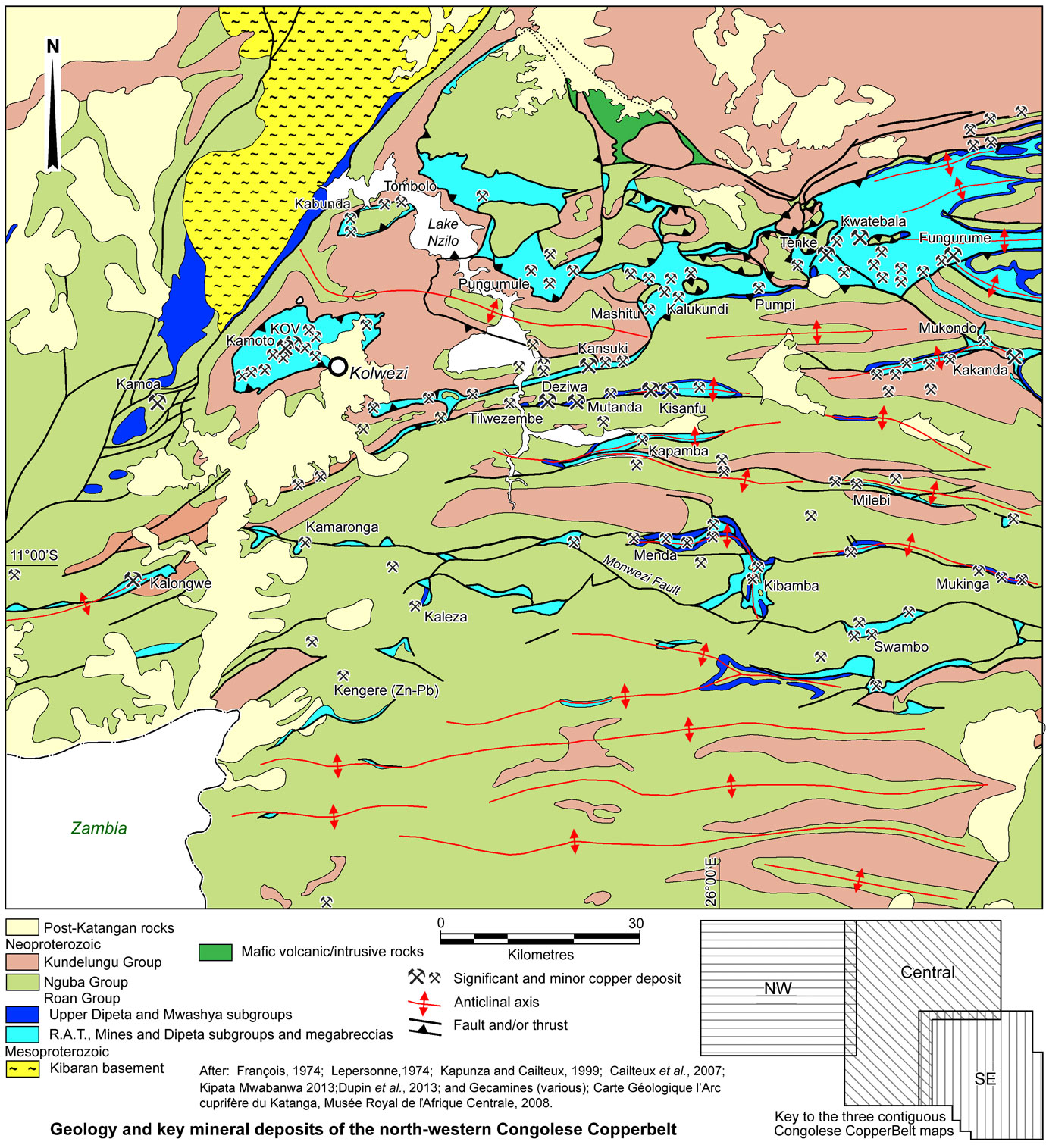
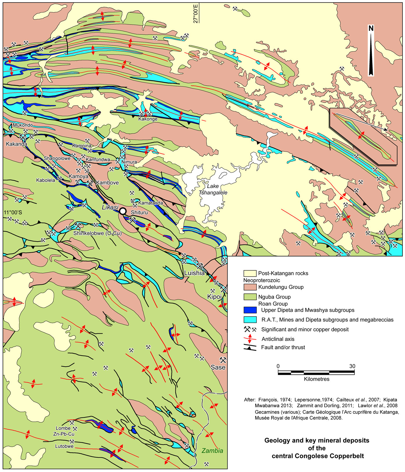
Following deposition of the Kansuki Formation, the stratigraphy of the Roan and succeeding Nguba and Kundelungu groups is more readily correlatable along the length of the Lufilian Arc. The transition between the pre-Kansuki facies occurs to the north of the Luina Dome, a basement high during the deposition of both sequences that straddle the Zambia-DRC border. Autochthonous to para-autochthonous Roan Group rocks of the Zambian Copperbelt facies (i.e., Lower and Upper Roan Subgroups) overlie Palaeo- and Mesoproterozoic basement in outcrop in Zambia, and on both rims of the Konkola and Luina basement domes near the Zambia-DRC border. Northward from the margins of these domes, Roan Group rocks are only exposed in the cores of a series of narrow, parallel, NW-trending, finger-like anticlines, which plunge very shallowly to the NW below younger Katangan rocks. Over this interval, no basement is exposed, Lower Roan type siliciclastic facies are not mapped and there is a transition from the Zambian to Congolese Copperbelt facies R.A.T., Mines and Dipeta subgroups. The crests of many of these anticlines, have been attenuated by axial plane, predominantly north- to NW-verging, reverse faults/thrusts, resulting in exposures of Roan Group rocks over lengths of tens of kilometres, with widths of <200 m to locally >5 km (see the SE Congolese Copperbelt geological map below).
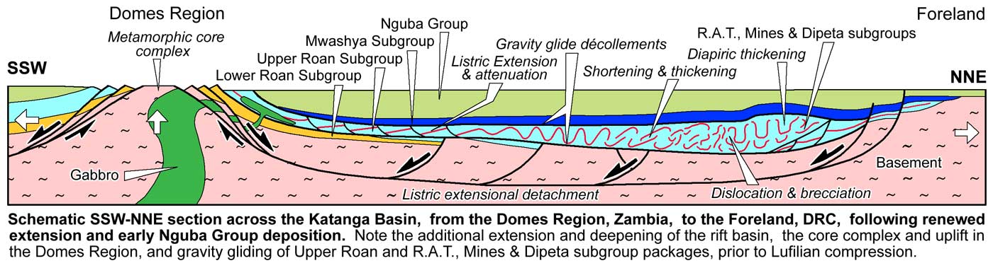
A second period of extension (or renewed extension) is reflected by the local intrusion of large ~765 to 736 Ma gabbroic sills in Zambia (commonly within the Upper Roan Subgroup dolostones, but also within the Nguba Group) and as pyroclastic and extrusive rocks within the Kansuki Formation of the Dipeta Subgroup, Mwashya Subgroup and lower Nguba Group in the northern part of the Arc in the DRC. Extension, correspondingly commenced during the deposition of the late Dipeta Subgroup, and continued into the Nguba group (~765 to 735 Ma), resulting in the deepening of the Katangan basin, and its enlargement by a further ~300 km to the NE, beyond the main Lufilian Arc, in the Kundelungu Gulf (Plateau or "Aulacogen") area, and draping Mwashya Subgroup and Nguba Groups rocks directly onto the flanking Bangweulu Block and Kibaran/Kasai Craton basement.
It is suggested here, that the string of high grade metamorphic domes in the Domes Region of Zambia (as distinct from the Kafue Anticline and satellite Konkola and Luina Domes to the east) are metamorphic core complexes, emplaced as a result of this same extension. Each is bounded by structural décollements separating basement and Katangan rocks, and they closely coincide with the broad WNW-ESE corridor of gabbroic intrusion in the same region (see the Domes Region geological maps in the Zambian Copperbelt record). It is further suggested that the uplift associated with these domes, and the coeval deepening of the rift basin and migration of the main depocentre to the north, influenced subsequent sedimentation, and initiated northward verging gravity gliding of the evaporite-rich Roan Group sediments already deposited. See the Tectonic and Structural Setting section below for more detail.
The ~200 to 250 m thick Mwashya (or Mwashia) Subgroup (R-4), is the uppermost member of the Roan Group, and conformably overlies the Kansuki Formation of the Dipeta Subgroup. It was emplaced within a deepening marine setting, and has been subdivided into three formations, the first of which includes a basal conglomerate, overlain by green to grey shales, a middle unit characterised by dark grey or black, pyritic carbonaceous shales and an upper feldspathic sandstone with carbonaceous shale facies in the basin centre (Cailteux et al., 2007):
The base of the overlying Nguba Group (previously the Lower Kundelungu) is defined by the 10 to 1300 m, northward thickening Grand Conglomérat, (or Mwale Formation; Ng 1.1) a regional, glacially derived sequence of variably clast-rich debris flows and diamictites with mudstone/siltstone/sandstone interbeds, some mafic flows and numerous iron formations, correlated with the world wide ~740 Ma Sturtian glacial event.
Whilst the Grand Conglomérat is conformable with the upper Mwashya Subgroup in some areas, elsewhere it has a discordant contact at different lithostratigraphic positions with the underlying succession. Locally, rocks of the Mwashya Subgroup are absent, or glacially eroded, and the tillite/diamictite directly overlies dolomites of the Kansuki Formation (François, 1973; Cailteux, 1991).
The Grand Conglomérat is locally overlain by a thin unit of banded shales with dolostone interbeds (Kaponda Formation; Schuh et al., 2012), and then the Kakontwe Limestone (or Middle Likasi Formation of Batumike et al. 2006; Ng-1.2), represented by 350 to 500 m of massive dolostones and limestones in Zambia, passing upwards and laterally into a thinner sequence of carbonate-bearing to carbonate-poor siltstones and sandstones in DRC, that fine from sandstones and siltstones in the north to shales in the south, This sequence appears to represent shallow marine to fluvial sedimentation, which has thinned to <130 m in the Tenke-Fungurume window where it includes the upper dolostones and shales of the Kipushi Formation (Schuh et al., 2012). Batumike (2006) includes a further unit, the Upper Likasi Formation (Ng-1.3), composed of slightly dolomitic arkosic siltstones, shales, sandy shales and sandstones. Ng-1.1 to 1.3 comprise the Muombe Subgroup (Ng-1) (or Likasi Subgroup of Batumike et al. 2006).
The remainder of the overlying Nguba Group, the Monwezi Subgroup (Ng-2) of Batumike et al. (2006), comprises dolomitic and arkosic sandstones, siltstones and shales, also becoming progressively finer and carbonate-rich to the south and is as much as 1000 m thick (Cailteux et al., 2007; Batumike et al., 2006, 2007). The Mwashya Subgroup and Nguba Group are widespread, deposited in a wide basin extending from the northern Kundelungu Gulf, south into Zambia to the Domes and Katanga High respectively. This basin is related to a prolonged period of extension (Batumike et al. 2006).
Mostly in the DRC, this succession is capped by the Kundelungu Group, the base of which is defined by the up to 50 m thick Petit Conglomérat, a glacial diamictite, believed to be the time-equivalent to the global ~635 Ma Marinoan glacial event (Hoffmann et al., 2004; Master and Wendorff, 2011). Geochemical, sedimentalogical and structural studies indicate the Kundelungu Group corresponds to a change from an extensional setting to compression, and the onset of basin inversion within the Lufilian Arc (Batumike et al., 2006). The Petit Conglomérat is overlain by a weakly metamorphosed and deformed sequence that passes upwards from limestones and dolomitic sandstones (the 'Calcaire Rose' that caps the diamictite), through dolomitic siltstones and argillites, to sandstones with lesser carbonate rocks. This sequence is then overlain by the extensive, undeformed, flat lying, non-evaporitic, continental clastic molasse succession of the Plateaux Subgroup, composed of argillaceous and arkosic sandstones, and conglomerates, deposited after ~572 Ma (Wendorff, 2003). The Plateaux Subgroup extends northeastward, beyond the Lufilian Arc as extensions of the overall Damaran-Katangan Belt, represented by two 'prongs' straddling the Bangweulu Block. In these latter zones, however, the undeformed tabular Plateaux Subgroup overlies folded upper Roan (Mwashya Subgroup) and Nguba Group rocks (Cailteux et al., 2005; Batumike et al., 2006, 2007). The Kundelungu Group is only found in the Kundelungu Gulf and within the External Fold and Thrust Belt in the DRC, but does not appear to be well represented (or differentiated) to the south of the Domes Region, or SW of the Kafue Anticline, in Zambia.
Click here for a wide composite of these three images of the full Congolese Copperbelt, best viewed on a large screen.
Megabreccias
The rocks of the R.A.T., Mines and Dipeta subgroups of the Roan Group in the DRC have undergone substantial structural mobilisation and internal deformation, and, in the mid to outer sections of the External Fold and Thrust Belt, are largely converted into megabreccias.
The rocks of these subgroups in the DRC are interpreted to have originally contained significant accumulations of salt, based on the abundant evidence of casts after evaporite minerals and the diapiric structures within the sequence, presumed to be the result of salt tectonics (François, 1973; Jackson et al., 2003). Selley et al. (2005) quote Warren (1999), who demonstrated that the formation of salt diapirs requires a minimum of ~500 m of halite. Such an accumulation is interpreted to have principally been within the structureless, poorly stratified, oxidised, variably dolomitic silts and breccias of the R.A.T. Subgroup, and possibly also the similar R.G.S. Formation in the lower Dipeta Subgroup. These units are interpreted to now represent the deflated insoluble residuum after the subsequent dissolution and removal of evaporites (Jackson et al., 2003).
In contrast, the complex, but generally stratiform geometry of breccia bodies in the Upper Roan Subgroup of the Zambian Copperbelt, and absence of diapiric geometries, suggests a relatively thin (<500 m) salt accumulation in that part of the basin. There are no comparable megabreccias within the Upper Roan Subgroup in Zambia (Selley et al., 2005).
These thick, ductile, evaporite-rich units within the R.A.T. and Dipeta subgroups, are interpreted to have influenced both pre- and syn-orogenic halokinetic movement within the sequence, promoting and 'lubricating' lateral detachment/décollement surfaces and vertical diapiric salt migration (François, 1973; Cailteux and Kampunzu, 1995; Binda and Porada, 1995; Porada and Berhorst, 2000). 'Lubrication' is the result of "solution-transfer creep", which occurs in salt beds when small quantities of water are introduced (Jackson et al., 2003 and references quoted therein). These structures modified the sequence, and are interpreted herein to have taken place as the result of both i). lateral gravity gliding and diapirism accompanying the second pulse of extension, and ii). mainly vertical diapirism, promoted by the increasing thickness (and weight) of overlying Nguba and Kundelungu groups sediments and by the subsequent, compressional Lufilian orogenic activity. The pre-orogenic gravity gliding in particular, and Lufilian orogenic nappe development, tightly folded the rocks of the R.A.T., Mines and Dipeta subgroups, and broke them into randomly oriented slabs, to form the ubiquitous megabreccias of the outer Lufilian Arc of the DRC (see the Tectonic, Tectono-sedimentary and Structural Setting section below).
Within these megabreccias, coherent sections of Mines Subgroup rocks are only preserved as elongate, slabs or écailles (French for 'fish-scales', a local structural term for tabular tectonic megabreccia blocks). Individual écailles generally represent the more brittle (silica-dolomite altered) units, and vary in size from a mm in diameter, to several km long by several hundred metres both down dip and in thickness, and are fault bounded on all sides. They are set within a matrix of R.A.T. Subgroup and comminuted gravel- to silt-sized, to rock flour of the same lithologies, including talc, dolomite, albite, quartz and/or Mg-rich chlorite (Annels, 1984; see the maps in the Tenke-Fungurume and Kolwezi records). Most écailles represent slabs of the Mines Subgroup that have not been randomly broken, but along the contacts with the underlying R.A.T. Subgroup and the overlying R.G.S. Formation, and/or Dipeta Subgroup rocks above the latter. The R.A.T., Subgroup and R.G.S. Formation represent the two main interpreted evaporite units. Openings across écailles of the Mines Subgroup within the RAT breccia are commonly filled in 'toothpaste' fashion by RAT injection breccias, cleanly crosscutting Mines Subgroup units and piercing up to the stratigraphic level of the CMN (Schuh et al., 2012).
Virtually all of the interpreted evaporites have been dissolved and removed, deflating the sequence and adding to the chaotic nature of the matrix and breccia. Although the écailles are scrambled, in many cases their gross alignment and orientation defines a broad folding pattern. The écailles forming the limbs of these structures, particularly in the Tenke-Fungurume window, are commonly (but not always) steeply dipping, culminate upward into dominantly flat-lying, mushroom-shaped caps and flower structures, and frequently comprise disrupted, overturned, isoclinal anticlinal folds, composed of multiple, complexly stacked blocks. This geometry is taken to be due to the underlying evaporites migrating upwards into antiformal structures, forcing the flanking écailles/limbs into near vertical salt walls and breaching the anticlinal crest (Schuh et al., 2012). The chaotic écailles of the thinner Kolwezi Klippe dip at both steep and shallow angles above an undulose, but shallowly dipping Lufilian detachment.
The Dipeta Subgroup has not been as widely brecciated, occurring only in écailles in some areas, although elsewhere coherent sequences, particularly the Kansuki Formation, underlie the succeeding Mwashya Subgroup which has not been brecciated.
Most of the copper orebodies within the the Congolese Copperbelt are hosted within écailles, and predate the structural dislocation that produced the megabreccias. Primary mineralisation is truncated abruptly at the margin of the host écailles, which may abut another écaille of a different lithology, that is either barren or mineralised, and oriented at a high angle to its neighbour.
Megabreccias and other breccias are found in a number of associations, namely:
• Thick sheet-like masses, up to >2000 m in thickness and covering areas of hundreds of km2, bounded above and below by shallow, regional detachments and/or nappe sole thrusts (e.g., the Tenke-Fungurume Roan Window). These sheets may also pass upward, via a breccia zone, into the Kansuki Formation (upper Dipeta Subgroup) and then little deformed Mwashya Subgroup rocks. This style may be interpreted to initially be the result of disruption and thickening by mass flowage as gravity glides, promoted and 'lubricated' by the low-strength evaporite units within the sequence, occurring during the early stages of dissolution of the evaporites. These stratabound, sheet-like masses are generally exposed in the outer margins of the arc, to the north and NE, overlain by the Mwashya Subgroup, the uppermost member of the Roan Group, and thrust over Kundelungu Group rocks that occur near the top of the Katanga Supergroup succession. These megabreccia sheets predominantly overlie a specific unit, Ku-2.1 of the Kundelungu Group over much of an area of ~1400 km2 (François, 1973; 1991; 1994). To achieve this relationship, the shallow evaporite 'lubricated' thrust surface at the base of the R.A.T, Subgroup would need to have penetrated to the surface soon after deposition of Ku-2.1 and transported an allochthonous sheet of Roan, Nguba and basal Kundelungu groups to the NE over an autochthonous sheet of the same rocks, during a rapid pulse of Lufilian compression.
Alternatively, Jackson et al. (2003) suggested the sheet-like masses of Roan megabreccia in the outer Roan windows and klippen, represent early Lufilian, 'salt glaciers', carrying entrained écailles. They suggest these glaciers were extruded over unit Ku-2.1 soon after deposition of the latter, and were mildly deformed by subsequent Lufilian deformation. Salt glaciers (namakiers) form when salt diapirs breach the surface and flow down hill before being dissolved. Currently active salt glaciers are well documented in arid regions, e.g., the 300 km2 Garmsar "salt nappe" in northern Iran. This option is also discussed by Schuh et al. (2012), but may not explain the preserved gross structure reflected by the alignment and orientation of écailles, in for example, the Dipeta Syncline (see the Tenke-Fungurume record). In current day salt glaciers, entrained/rafted non-evaporitic slabs and clasts tend to be dumped in a jumbled moraine at the limit of a dissolving salt glacier, usually <5 km from the breaching diapir in an ultra-arid climate.
A narrow interval at the leading edge toe of an allochthonous sheet of Roan, Nguba and basal Kundelungu groups, advancing over unit Ku-2.1, above a basal salt unit/thrust surface (R.A.T. Subgroup), would resemble a salt glacier.
• Diapiric masses in anticlinal cores, particularly those that have undergone axial plane thrusting/faulting (e.g., Etoile).
• Diapiric masses in dilational jogs in regional oblique, strike-slip fault zones, such as the Monwezi Fault. Both of these diapiric variants are interpreted to be due to salt diapirs (both as dykes and sills) cutting the Mwashya Subgroup, Nguba and Kundelungu groups, carrying entrained écailles of the Roan Group sedimentary rocks originally intercalated with the evaporites, with halokinesis initiated by the loading of the Nguba and Kundelungu groups. These discordant breccias are frequently rooted in, and usually post-date the thick, layer-parallel sheet-like breccias.
• More localised tectonic breccias are found in association with local thrusting and detachments within écailles and where megabreccias cut other units higher in the sequence.
• To the south, in Zambia and on the DRC border, zones of brecciation are evident within the Upper Roan carbonate sequence. They are usually composed of rounded to angular, mm to metre sized polylithic intraformational clasts, set in a crystalline matrix of carbonate, albite, quartz, anhydrite and or magnesian chlorite. These breccias may be single cm to metre thick bands, to stacked complexes, up to several hundred metres thick. In general they are stratabound, but on a larger scale, step down through the sequence to the south and west. They are interpreted to represent solution collapse breccias following the dissolution of evaporite bands, and are different in character to the much more extensive megabreccias in the DRC.
Stratigraphy of the Congolese Copperbelt Roan Group
The detailed stratigraphy of the Roan Group, which hosts most of the Cu-Co major deposits of the Congolese Copperbelt, is as follows, from the base (images of the key R-1 and R-2 lithologies described below are included in the Tenke-Fungurume and Kinsevere records):
R.A.T. Subgroup (R-1)
• R.A.T. Lilas (or R.A.T. Rouges), is 0 to at least 225 m thick - comprising hematitic, reddish, chloritic (Mg chlorite) and dolomitic siltstones with some sandstone, and one dolostone band (Bartholomé et al., 1973). These rocks are Mg-rich, with abundant dolomite, magnesite, Mg-chlorite and some talc (Cailteux et al., 2005). The chlorite-dolomite occurs mainly as a cement, and increases towards the top of the sequence (Cailteux, 1994). The most characteristic feature of the R.A.T. Lilas is the uniformly red to lilac colour due to ubiquitous disseminated hematite, both as authigenic plates and red pigment in minerals such as quartz, dolomite and tourmaline (Cailteux, 1994). Detrital quartz, micas and chlorite are abundant in most bands, but some dolomite is always present. There are no sulphides. Coarse banding is observed, but laminations are quite uncommon (Bartholomé et al., 1973).
The composition of the R.A.T. has been interpreted as indicative of an evaporitic depositional environment and/or extreme metasomatism, lying below the highly evaporitic beds of the Kamoto Formation (Cluzel, 1985; Moine et al., 1986; Kampunzu et al., 2005). The base of the R.A.T. Subgroup is everywhere truncated against breccia, which resembles monomictic to polymictic conglomerate, but is considered to represent a residuum after the dissolution of tectonically mobilised evaporites (Hitzman et al., 2012 and references cited therein).
The R.A.T. Lilas has been subdivided into a lower R-1.1 - ~40 m of mostly sandy, purple-red, hematitic, slightly dolomitic siltstones with irregular coarse bedding; R-1.2 - ~45 m of pink to purple-grey argillaceous siltstones, with minor dolostone. Sandstones ('grés ocellés') are interbedded in the lower sections, whilst a pink silicified dolostone with occasional stromatolites occurs at the top, of this unit; R-1.3 - ~150 m of pink-lilac chloritic-dolomitic siltstone, which is commonly brecciated, and is characterised by desiccation cracks and carbonate-quartz pseudomorphing after anhydrite/gypsum. R-1.3 is interpreted to represent an original, frequently emergent, lagoonal evaporitic sequence that preferentially influenced the position of, and lubricated, the detachment that forms the top of the R-1 Subgroup, but has subsequently undergone evaporite dissolution and migration that resulted in deflation and brecciation (François and Coussement 1990, unpub.; Cailteux, 1994). Although tectonic/dissolution breccias generally form the contact with the overlying Mines Group (R-2), a continuous sedimentary transition has been established at some localities (Porada and Behr, 1988).
Mines Subgroup (R-2)
Kamoto Formation (R-2.1) - formed in a quiet, shallow-water, high-salinity environment, marking the progressive onset of a marine transgression (Bartholomé, et al., 1973; Cailteux, 1994).
• R.A.T. Grises, (R-2.1.1) 0.5 to 2 m thick - grey, chloritic and dolomitic siltstone, mineralogically similar to the R.A.T. Lilas, distinguishable by the colour and absence of hematite, which is replaced by sulphides (pyrite and chalcocite). The rock type is basically an unstratified sandstone (average particle size 0.3 mm), with most of the particles being angular quartz, which comprise 35% of the rock type by mass. The other constituents, mainly the matrix, are entirely phyllitic and are probably the product of in situ alteration. They include finely disseminated dolomite, talc and Mg-chlorite, but no magnesite (which is abundant in the overlying member). The quartz and chlorite are predominantly authigenic (François and Coussement 1990, unpub.; Bartholome, et al., 1973). Some authors include this unit in the R.A.T. Subgroup (R-1).
• D.Strat., (Dolomies Stratified) and R.S.F., (Roches Siliceuses Feuilletées), (R-2.1.2), 7 to 9 m thick - consisting of grey, laminated, fine-grained, argillaceous and chloritic, dolostone beds with variable amounts of magnesite in the lower sections, namely the D.Strat., and increasing amounts of authigenic quartz in the upper part, to form the siliceous, finely bedded dolostones, laminitic stromatolites and chloritic-dolomitic siltstones of the R.S.F. beds which are almost completely composed of magnesite or authigenic quartz. The laminations are on a millimetric scale. Together they form a consistent member throughout the Congolese Copperbelt. The D.Strat. includes a layer with casts after evaporitic minerals and 1 to 5 cm diameter elliptical nodules of dolomite, chert and sulphide which is present everywhere. The bedding of the host rock is wrapped around the nodules, both above and below. It is suggested that they represent former anhydrite concretions. The D.Strat. is magnesite rich, interpreted as a modified Mg rich evaporite. This unit and the underlying R.A.T. Grises, is the host rocks to the Lower Orebody position, where present at each of the Congolese Copperbelt deposits (Bartholome, et al., 1973; Cailteux, 1994; Cailteux et al., 2005; Hitzman et al., 2012).
• R.S.C., (Roches Siliceuses Cellulaires) (R-2.1.3), 10 to 30 m thick - originally composed of massive, stromatolitic dolostones, and lesser interbedded dolomitic siltstones, with casts after evaporite minerals, but now consisting almost exclusively of dolomite and secondary quartz. There are three facies across the Copperbelt (François and Coussement 1990, unpub.): i). Southern facies, 0 to 25 m thick - lenticular algal biostromes; ii). Intermediate facies, 15 to 20 m thick - coarse-grained breccia of siliceous dolostone, with some algal fragments; iii). Northern facies, 10 to 25 m thick - fine-grained breccia of siliceous dolostone, without recognisable algal fragments - see the Mineralised Facies within the Mines Subgroup section below for more detail.
The R.S.C. is a massive heterogeneous, silicified dolomite that was first dolomitised, resulting in dolomite porphyroblasts up to 10 cm across, and then subsequently silicified. Remnants of Collenia stromatolitic structures have been found within the member, but most of the rock is massive and coarse-grained as a result of intense recrystallisation, preserving only some of the macro structure. On weathering, the remaining dolomite is dissolved, leaving a cellular siliceous rock with macroscopic pores. It is largely devoid of sulphides and of carbonaceous material, and usually has no laminations, in contrast to the beds above and below (Oosterbosch 1951; Bartholomé, et al., 1971; 1973; Cailteux et al., 2005; Hitzman et al., 2012).
Dolomitic Shales Formation (R-2.2)
• S.D., (Schistes Dolomitiques), 30 to 110 m thick - which overlies the R.S.C. with an abrupt conformable contact, passing into a 5 to 10 m thick basal dolomitic shale (Shales Dolomitiques de Base, or S.D.B.) deposited in a shallow-water, high-salinity, intertidal environment, similar to R-2.1.2, characterised by lenticular beds and nodules pseudomorphed after anhydrite. This is overlain by the 'Black Ore Mineralised Zone' (B.O.M.Z), an ~2 m thick band of silty and chloritic dolostone, coarsely crystalline dolostone and dolomitic shales, with 1 to 5 mm diameter ellipsoidal nodules and concretions in its lower sections, pseudomorphed after anhydrite, now composed of dolomite, quartz, sulphides and chlorite. The S.D. is largely composed of an alternation of mostly laminated, parallel-stratified, locally carbonaceous, dolomitic shale and dolomitic siltstone beds, representing clastic material cemented by a micritic dolomite. This overall transgressive unit represents the maximum flooding area within the Mine Subgroup. Disseminated microscopic pyrite is present in most of the formation, and may be accompanied by chalcopyrite (Bartholome, et al., 1971).
Although the S.D. has a number of lateral facies variants (see below), the simplest is a threefold repetition of grey to grey-green dolomitic siltstone overlain by dark grey or black carbonaceous shale which form three regular carbonaceous markers that may be identified within the S.D. succession throughout the Congolese Copperbelt. The S.D.B. (S.D.-1a) and B.O.M.Z. (S.D.-1b) represent the lowest of these three cycles, and host the Upper Orebody, where present (François and Coussement 1990). The second cycle comprises: S.D.-2a - black carbonaceous weakly dolomitic shale; S.D.-2b - dolomitic shales, with frequent stromatolitic dolostone beds at the base; S.D.-2c - strongly dolomitic shales, with occasional black carbonaceous shales at the base; and S.D.-2d - black carbonaceous weakly dolomitic shale. The third, and uppermost cycle is composed of: S.D.-3a - strongly dolomitic shales, with occasional stromatolitic dolostone beds at the top or base; and S.D.-3b - black carbonaceous weakly dolomitic shale (Cailteux et al., 2005).
Progressively to the north, dolostones and then feldspathic sandstones appear, interbedded with the siltstones. The S.D. occurs above all of the R.S.C. regional facies, but is best developed above the Intermediate Facies where the stratabound ores are the richest. The S.D. is very regular, except for cross bedding in some of the sandstone lenses. The recurrence of evaporitic nodules at the top of the third cycle indicates the onset of a regression and the return to shallow-water conditions at the end of S.D. deposition (Cailteux 1977; 1983).
Kambove Formation (R-2.3), up to 190 m thick. Renewed marine transgression occurred during deposition of the lower Kambove Formation, resulting in a return to subtidal carbonates and/or dolomitic siltstones. The upper Kambove Formation corresponds to another regression, and locally evaporitic, silicified, intertidal carbonate rocks. The resulting sequence is as follows:
• C.M.N., (Calcaire á Mineral Noir) - composed of a:
Lower C.M.N., R-2.3.1 - generally dark dolostones, enriched in organic matter, that is composed of three cycles, i). R-2.3.1.1 - variably carbonaceous, massive, stromatolitic dolostone with interbedded dolomitic shales and laminated dolostones; ii). R-2.3.1.2 - variably carbonaceous, laminated dolostones with tabular stromatolites, talcose towards the top; and iii). R-2.3.1.3 - variably carbonaceous, talcose, massive or finely bedded dolostones, with occasional oolitic or cryptalgal beds,
Upper C.M.N., R-2.3.2 - generally clean dolostones containing interbedded, chloritic-dolomitic siltstones, which is divided into three members, i). R-2.3.2.1 - pink-brown to white massive dolostone; ii). R-2.3.2.2 - variably carbonaceous, massive dolostones with occasional stromatolites, more or less talcose, finely bedded dolostones, with interbedded chloritic-dolomitic siltstones, occasional evaporitic-type collapse breccias and intraformational conglomerates; and iii). R-2.3.2.3 - white to pink massive dolostones, and more or less talcose, finely bedded dolostones, with interbedded grey to pink-red chloritic-dolomitic siltstones, occasional evaporitic-type collapse breccias and intraformational conglomerates.
At some localities, lenses of ore are found in units R-2.3.1.1 to R-2.3.2.2 respectively.
Dipeta Subgroup (R-3), which is ~600 m thick.
• R.G.S. Formation, (R-3.1) (Roches Gréso-Schisteuses), ~155 m thick, at the base of the Dipeta Subgroup, representing an abrupt sea level regression or basinward shift of facies to clastic rocks, similar to those of the R.A.T. Subgroup (Hitzman et al., 2012 and references cited therein). It can be subdivided into:
R-3.1.1, ~10 to 35 m thick, composed of reddish, hematitic, fine-grained siltstone and, locally, conglomerates, overlain by coarse, medium or fine-grained arkosic sandstones/quartzites with silty and dolomitic interbeds (Schuh et al., 2012; Hitzman et al., 2012; Cahen, 1974).
R-3.1.2, ~120 m of alternating grey or white stromatolitic dolostones, alternating with grey dolomitic shales with green pelitic horizons (Schuh et al., 2012; Hitzman et al., 2012; Cahen, 1974).
The remainder of the overlying Dipeta Subgroup, contains evaporitic lagoonal deposits, stromatolitic carbonate units, and deeper water dolomitic shales and siltstones that formed in repeated regressive and transgressive sedimentary cycles, each beginning with siliciclastic deposits and ending with thinly bedded carbonates, similar to the sediments of the Mines Subgroup (Cailteux, 1994; Hitzman et al., 2012), as follows:
• Lower Mofya Formation, (R-3.2), comprising (Schuh et al., 2012; Cahen, 1974),
R-3.2.1, a lower 30 m of grey to violet sandy pelites, followed by,
R-3.2.2, 21 m of dolostone with banks of greenish sandy pelites and one or more stromatolitic horizons.
• Upper Mofya Formation, (R-3.3), comprising (Schuh et al., 2012; Cahen, 1974),
R-3.3.1, >100 m of purplish-grey, sometimes yellow sandy pelites, overlain by a hiatus in deposition, represented by silty breccias, interpreted to represent a dissolved evaporite horizon (François, 1992).
R-3.3.2, in the Tenke-Fungurume window, this unit comprises 50 m of grey, massive, vuggy dolostone, overlain by 19 m of sandy, pyritic dolostone with asbestos (riebeckite, crocidolite) and an upper interval of 98 m of dolostones and marly dolostones, with an oolitic horizon, andalusite porphyroblasts in the middle, and another oolitic band near the top (Schuh et al., 1012).
• Kansuki Formation (R-3.4) (the uppermost unit of the Dipeta Subgroup, previously the Lower Mwashya), an 80 to 390 m thick (thickening from SW to NE) sequence of carbonate and related volcaniclastic rocks. It is mostly separated from the underlying Dipeta sequence by a structural contact, marked by an evaporite-facilitated breccia-detachment, although it is locally conformable via a transition zone that includes grey to red, sandy, oxidised rocks, which contain beds of pink dolomite with ferruginous oolites.
The Kansuki Formation is characterised by alternating reefal to intertidal deposition, comprising laminated and massive stromatolitic or arenaceous dolostones, oolitic dolostone, erosional surfaces, intraformational conglomerates and pseudomorphs after anhydrite near the top of the formation. The Kansuki Formation also contains ~765 Ma (Key et al., 2001) mafic lavas, and extensive, 2 to 12 m thick beds of associated pyroclastic flows and volcaniclastic rocks interbedded with dolostones, defining a regional 'volcanic belt'. These rocks are mapped from the Shinkolobwe, Kambove, Shituru, Mulungwishi and Luishia areas in the west to Luiswishi, and to the Musoshi and Kinsenda areas along the Congo-Zambia border in the southeast (Cailteux et al., 2007). Comparable rocks are found in the Mwinilunga area, northwestern Zambia, suggesting the belt extends westward towards the Angola-DRC border also (Key et al., 2001). At Kambove and Kamoya, two units of stratified to massive upward fining, mafic, grey-green to green-brown debris flow tuffs were deposited within the carbonates. The lower and upper tuffs, which are respectively 12 and 11 m thick, are separated by ~3 to 4 m thick white, partly recrystallised dolomite, the upper part of which is replaced by a massive ≤5 m thick hematite bed or interbedded hematite with sideritic or hematitic carbonate rocks, found at many locations where the Kansuki Formation in exposed in the folded Lufilian Arc (Cailteux, 1983, 1994; François, 1974). The base of the overlying upper tuff often contains millimetre size clasts of hematite. These volcanic rocks are considered to be the extrusive equivalents to the 742 to 753 Ma voluminous gabbroic bodies emplaced within rocks of the Dipeta and Upper Roan subgroups in the DRC and Zambia respectively (Cailteux et al., 2007). In the Tenke-Fungurume window, this sequence is represented by (Schuh et al., 2012):
R-3.4.1, ~60 m of fine, hard, purple sandstone, with polyhedral cavities, followed by a hiatus in deposition, represented by silty breccias, interpreted to represent a dissolved evaporite horizon (François, 1987; 2006).
R-3.4.2, >18 m of strongly faulted rocks at the base, overlain by fine sandy shales, alternating with dolostones and 1 to 2 stromatolitic horizons.
R-3.4.3, ~10 m of silicified dolomite with oolitic and hematitic horizons, locally including ironstones and mafic pyroclastics (20 km SE of Tenke Fungurume).
Mwashya Subgroup (R-4), which is 200 to 250 m thick.
• Kamoya Formation (R-4.1), an ~45 to 180 m thick unit, characterised by irregularly bedded dolomitic shales to siltstones. The basal ~27 m of this suite includes several intercalated discontinuous beds of dark grey to black massive chert, two bands of ferruginous, oolitic dolomitic, to silicified rock, and unsorted matrix-supported, conglomerates with sub-angular to rounded chert clasts, constituting a regional marker (the "Conglomerate de Mwashya"). The cherty clasts within the conglomerate exhibit an alternation of opaline layers marked by black impurities (carbon?) and microcrystalline layers containing pyrite and quartz grains, with lesser tourmaline, titanite, zircon and euhedral apatite. To the north, the succession is defined by 190 to 220 m of greenish-grey shales and siltstones, with ~1.5 m of matrix-supported conglomerate at the base.
• Kafubu Formation (R-4.2), an ~75 to 140 m thick sequence of finely bedded, grey to dark grey or black, pyritic carbonaceous shales with local sandy, silty and dolomitic interbeds; and
• Kanzadi Formation (R-4.3), generally <40 m thick, composed of mm to cm to m-thick beds of pink to green feldspathic sandstone, arkose or conglomeratic arkose, alternating with variable amounts of shale or siltite, representing tidal flat or fluvial deposition. There is a lithofacies variation of the Kanzadi Formation, with sandy lithologies on the northeastern and southwestern margin of the External Fold and Thrust belt, and dominantly dark shales in the centre. A mafic lapilli tuff at Likasi has been dated at 765 to 735 Ma (Rainaud et al., 2000).
To the south, in Zambia, the Mwashya (or "Mwashia") is 150 to 650 m thick, dominantly represented by fine-grained and finely bedded argillaceous and carbonaceous shales
(Mendelsohn, 1961), often with a conglomerate at the base, similar to the "Conglomerate de Mwashya" and variable intercalated dolomitic or dolostone beds. The base of the unit is often marked by a breccia (Cailteux et al., 2007).
Tectonic, Tectono-sedimentary and Structural Setting
The Lufilian Arc comprises five distinct, north-convex, arcuate tectonic subdivisions (after Kampunzu and Cailteux, 1999), the:
i). Katanga Core or Katanga High, to the southwest, in which only sections of the upper parts of the Katanga Supergroup (Nguba Group and possibly some Kundelungu Group) and most of the outcropping granitic intrusions of the Lufilian Arc are exposed, although these most likely overlie a concealed Roan Group succession in the core of the Katangan Basin (Petters, 1986; Selley et al., 2005). This block is marked by a more complex and variable pattern in aeromagnetic data, apparently related to the distribution of Late Lufilian magmatism.
ii). Synclinorial Belt, where sediments are subjected to large scale folding during at least two deformation events, and low grade metamorphism, which it has been suggested, reflects a change from a marginal shelf in the north, in what is now the External Fold and Thrust Belt, to a deeper basin (Cosi et al., 1992; Porada and Berhorst, 2000) south of the Domes Region. However, Selley et al. (2005) suggested that they could find no evidence for a deeper marine sequence in the Synclinorial Belt. It is reflected by a more subdued pattern in magnetic data, sandwiched between its neighbouring regions;
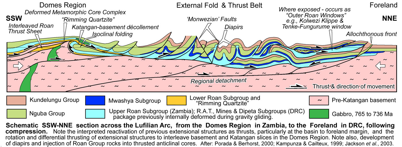
iii). Domes Region, which comprises a corridor of exposed basement domes, characterised by upper-greenschist to upper-amphibolite facies metamorphism. These domes resemble metamorphic core complexes, capped by domal, radially outward-dipping detachments/décollements. The rocks above the décollement are usually metamorphosed to greenschist facies and comprise Katanga Supergroup lithologies, while those below are strongly metamorphosed Palaeo- and Mesoproterozoic gneisses and schists, with interpreted interleaved metamorphosed Neoproterozoic slices, and include quartz-feldspar-biotite±magnetite gneisses, garnet-bearing granite gneisses, talc-kyanite schist, etc., with a strong mylonite texture (cf., at Lumwana). Peak metamorphic conditions in the western Domes have been defined by talc-kyanite white-schists within the décollements between the basement and the Katangan Supergroup sedimentary sequence in the Domes (Hitzman et al., 2012), dated at ~530 Ma (John et al., 2004), most likely due to reactivation as thrust surfaces during Lufilian compression. Note: - white schists are low temperature and high to ultra-high pressure Mg-rich assemblages, often associated with evaporitic, or volcanic protoliths, altered by metasomatic processes prior to metamorphism.
The belt is also characterised by a corridor of gabbroic intrusions, cutting both the basement in the domes, Upper Roan Subgroup and Nguba Group country rocks.
Daly et al. (1984) interpret the basement inliers in the Domes region to represent structural culminations developed above mid- to lower crustal ramps that splayed off a deep crustal detachment. It is likely that, if they are extensional metamorphic core complexes, they have been subsequently deformed during the late Lufilian compressive event during basin inversion to the form described by Daly et al. (1984).
The individual domes coincide with magnetic highs within a well defined arcuate belt of greater magnetic relief than in the neighbouring Synclinorial Belt.
Selley et al. (2005) included the Kafue Anticline within the Domes Region, contrary to earlier authors (e.g., Unrug, 1983; Wilson et al., 1993; Hanson et al., 1994; Binda and Porada, 1995; Kampunzu and Cailteux, 1999). It is more extensive than the individual domes with a different trend, and can be demonstrated more readily to have been a basement high during deposition of the Roan Group. However, it does share many of the compressional features seen in the domes to the west, locally fringed by compressional décollement structures (e.g., in the Nchanga-Chingola and Nkana-Mindola districts) with interleaving basement and Roan Group thrust slices (as at Chingola), and has undergone Lufilian thrusting. Never the less, it has here been included within the Domes Region to conform to more recent convention. The Domes region in Zambia, if the Kafue Anticline is included, hosts all significant Cu-Co deposits of the Zambian Copperbelt.
iv). External Fold and Thrust Belt to the northeast, characterised by an outward, arcuate transition from folding and thrusting adjacent to the Domes Region, into thin-skinned thrust and nappe-dominated deformation, all of which is north to NE verging. It is also characterised by the absence of exposed basement north of the Luina Dome, and by low-grade metamorphism. This belt is broadest in the DRC, between Lubumbashi and Tenke-Fungurume, but narrows markedly to the west where it changes trend from WNW-ESE to NE-SW, limited on its western margin by the Angola/Kasai craton and Kibaran basement, and to the SE by the Domes Region basement. It hosts the bulk of the major copper deposits of the Congolese Copperbelt;
v). Kundelungu Gulf Foreland to the far northeast, an extension of the Katanga Basin within the DRC, produced during the second period of extension, characterised by less deformed Mwashya Subgroup and Nguba Group sedimentary rocks, and deposition of undeformed, Plateaux subgroup molasse rocks of the late Kundelungu Group, during and following the main compressive stage of the late Lufilian orogeny. Local windows of Roan Group rocks are also recognised to the NE. A second, similar foreland prong stretches east from the Zambian Copperbelt, separated from the first by the triangular Bangweula Block.
The following is a synthesis and interpretation, based on the varying interpretations and descriptions of the Neoproterozoic to Palaeozoic tectonics of the Lufilian Arc available in the literature:
• Early Extension, which followed an ~200 Ma period of quiescence, and marks the early onset of the break-up of the Rodinia Supercontinent. This resulted in the commencement of deposition of the Katanga Supergroup in narrow grabens in Zambia, which became interconnected and grew into a larger rift basin. The earliest deposition was in the Zambezi Belt, to the south of the Mwembeshi Shear Zone in Zambia and Zimbabwe, where it was accompanied by rift volcanic rocks (mainly dolerites) which yielded zircon ages of ~880 Ma (Frimmel et al., 2011). The localised coeval 877±11 Ma (Rainaud et al., 2000) A-type Nchanga Red Granite at Nchanga in the main Lufilian Arc of Zambia, is overlain by the basal Katanga Supergroup above an erosional contact. Similar aged granitoid intrusives are also known in the basement core of Mwombezhi Dome in the Domes Region of Zambia (Barrick Gold, 2014).
During this phase of extension, a NNW-SSE trending, fault bounded composite structural high developed, occupying what was to become the core of the D2 Kafue Anticline in Zambia, influencing the distribution and thickness of facies (see the separate Zambian Copperbelt record for detail and a cross section). This structure faded to the north in the DRC, where its northern extremity is represented by the Luina Dome, which straddles the frontier. The base of the Roan Group sequence, and the predominantly siliciclastic Lower Roan Subgroup, well represented in Zambia, has only been observed in the DRC on the rims of the Luina Dome, and on the fringes of the Kundelungu Gulf Foreland. It would appear that most Roan Group rocks in the DRC, which comprises the R.A.T, Mines and Dipeta subgroups, represent transgressive sag phase carbonatic facies equivalents of the uppermost Lower Roan and the Upper Roan subgroups in Zambia, that have spread onto basement beyond the margin of the main rift. Deposition during this period in the DRC is predominantly of shelf to lagoonal dolomite and dolomitic shales to marls, passing laterally to the north and NE into mudflat and siliciclastic marginal facies domains in the Kundelungu Gulf Foreland and onto the Kibaran basement margins (Porada and Berhorst, 2000). To the SW, the dolomitic shales facies pass into more reefal environments, represented by stromatolitic algal biohermal developments, with lesser fine sedimentary rocks, presumably developed on a basement rise, fringed by sedimentary rocks containing clasts of stromatolites and reef debris (François, 1973, 1974; Lefebvre, 1979; Cailteux, 1978; 1983; 1994). Further to the south and SW, although largely under cover, the dolomitic shales become the marine shelf sequence of the Upper Roan Group in the Domes Region of Zambia (west of the Kafue Anticline basement high), underlain by clastic rocks of the Kitwe Formation of the Lower Roan Subgroup that, in turn, overlies metamorphic basement.
• Renewed Extension, from ~765 to 735 Ma (Key et al., 2001; Barronet al., 2003; Hitzman et al., 2012), corresponding to the deposition of the Mwashya Subgroup and Nguba Group. During this period, the main centre of deposition moved north from the region principally to the west of the "Kafue Anticline" basement ridge in Zambia, to be located in Katanga in the DRC, where shallow shelf to lagoonal carbonate rocks had previously dominated during Roan Group deposition. The main deeper (black shale) facies of the Mwashya Subgroup are between Lubumbashi and Kolwezi, and from north of the Domes Region in the SW, to the transition to the Foreland in the NE. The Nguba Group is similarly well developed over the same interval, but also spreads south across the Domes in Zambia, while the succeeding Kundelungu Group is largely confined to the area north of the Domes Region and onto the Foreland.
It is suggested here, that this renewed extension also resulted in the development of a corridor of metamorphic core complexes in the Domes Region, overlapping and merging with the southern margin of the Kafue Anticline to the SE. The latter, had formed as a faulted basement high during or prior to the Early extension. This renewed extension and core complex development was accompanied by the emplacement of a coextensive corridor of mantle derived 742 to 753 Ma (Barron, 2003) gabbroic masses and sills (see the Domes Region maps in the Zambian Copperbelt record).
During this same period, tholeiitic mafic dykes and sills, and lenses mafic to felsic lavas and tuffs (Kampunzu et al., 1991; 1993; 2000; Meert and Van der Voo, 1997; John et al., 2003) were extruded mainly in the Upper Roan Subgroup, Kansuki Formation of the Dipeta Subgroup, Mwashya and Grand Conglomérat (Nguba Group) sequences (Kampunzu et al., 2000). The volcanic facies were not thick, or widespread, being recognised as far east as Likasi (in the Kansuki Formation), with the best developments in the Nguba Group along the western margin of the Katangan basin with the Kibaran basement west of Kolwezi in the DRC, and in NW Zambia. Interstratified mafic volcanic rocks at the base of the Grand Conglomérat have been dated at 735±5 Ma (U-Pb zircon age; Key et al., 2001).
Hitzman et al. (2012) suggest halokinesis of Roan Group evaporites deposited in the main Katangan basin was probably initiated during Mwashya to lower Nguba time, and influenced the depositional thickness of the Nguba Group (quoting D. Selley, unpub. data, 2005). Halokinesis is, in turn, interpreted to have produced the megabreccias affecting much of the R.A.T., Mines and Dipeta subgroup rocks in the External Fold and Thrust Belt of the Lufilian Arc in the DRC. In the process, these three units have been irregularly folded about axes that are not consistent with the main Lufilian fold framework, and the salt/anhydrite largely removed. Halokinetic deformation and brecciation has affected the Dipeta Subgroup as high as the base of the Kansuki Formation, which is commonly separated from the underlying rocks of the same subgroup by a tectonic breccia zone. As a consequence, the largely intact Kansuki Formation has until recently been considered to represent the Lower Mwashya Subgroup which it directly underlies (Cailteux et al., 2007). The main Lufilian compressional thrusts and nappes have defined contacts with the megabreccias, distinct from the chaotic and irregular folds and faults within the megabreccia.
It would seem likely that the main period of halokinesis took place after deposition of the Mwashya Subgroup and early Nguba Group rocks, prior to the main Lufilian compressional event, although mainly diapiric activity is evident during the latter, concentrated in dilational jogs in strike slip faults and anticlinal axial plane thrusts.
It is suggested here, that both uplift and seismic activity associated with emplacement of metamorphic core complexes and gabbroic intrusions in the Domes Region, and renewed subsidence to the north in the relocated depocentre in the DRC, led to an evaporite-induced intraformational gravity gliding event (c.f., the Cretaceous Congo offshore basin and Gulf of Mexico; Rowan et al., 2004; Gulf of Lions in the Mediterranean; Reiset al., 2008). The gliding would have taken place over evaporite lubricated detachments in the R.A.T., Subgroup and other surfaces within the package, to the uppermost significant evaporite, found near the base of the Kansuki Formation, below the already deposited Mwashya Subgroup and the Nguba Group which was being deposited concurrently. Transport would be inward, as the renewed extension subsided, away from the uplifted metamorphic core complexes of the Domes Region to the SW and the main basin margin on the edge of the Foreland to the NE. This style of gliding results in listric style extension, attenuation and lateral movement down-slope on the margins of the basin, and compression, thickening, folding, imbrication and dislocation towards the deepest section of the basin, accompanied by the formation of a diapiric thickening of the package. This movement is accompanied by dissolution of the evaporites and additional deflation of the overlying basin floor, thus influencing deposition of the overlying sequence. It would also result in some transport the Mwashya Subgroup towards the basin centre. It is suggested here that this process produced the main bulk of megabreccias, prior to the onset of Lufilian compression. It would have resulted in a package to the NE that was internally brecciated, dislocated, folded and dismembered, with a variable thickness due to dissolution and attenuation in some areas, and imbrication and local diapiric thickening towards the basin centre.
The heterogeneous distribution of strain during this event, focused the maximum strain along listric faults and gravity glide detachments, most likely controlled by evaporitic layers (Cailteux, 1994; Cailteux and Kampunzu, 1995), which explains the absence of strong fabric within the rocks (Kampunzu and Cailteux, 1999).
As detailed above, this stage of halokinesis and megabreccia formation post-dated ore formation within the Mines and Dipeta subgroups.
The two preceding extensional phases were related to two pulses in the NW-SE opening of the Damaran-Katangan rift basin, between the composite Congolese and Kalahari cratons, during the break up of Rodinia. The basin inversion in the following Lufilian compressional phases heralds the formation of the new, short-lived Pannotia supercontinent, and in particular the east-west closure and collision that formed the north-south Mozambique belt to the east. This belt extended along the current east coast of Africa, from Antarctica in the south, to the Arabian Peninsula in the north. The stress field related to this closure produced pronounced sinistral movement on the WSW-ENE trending, transcontinental Mwembeshi shear zone to the south, and the parallel Monwezian strike-slip faults in the Lufilian Arc further north.
• Kolwezian tectonic event, D1 of François (1974) and Kampunzu and Cailteux (1999), commencing at ~590 Ma (Hitzman et al.< 2012), the initial phase of the Lufilian Orogeny that persisted over the interval from 590 to 512 Ma (Armstrong et al., 2005), with peak metamorphism at ~530 Ma (John et al., 2004). This event represents the structural inversion of the Katangan rift basin. It involved large scale thrust sheet and nappe development within the Lufilian Arc, with tens of kilometres of transport of allochthonous sheets to the north and NE (François, 1973; Cailteux and Kampunzu, 1995; Binda and Porada, 1995; Porada and Berhorst, 2000; Selley et al., 2005). It is characterised by complex polyphase deformation, superimposed thrust terranes and curved folds, together with higher-angle reverse faults. Selley et al. (2005) suggests that kinematics indicate a change from NW to NE directed thrusting from west to east respectively, with displacement vectors radiating perpendicular to the arcuate trend of the fold belt. Kipata (2013) suggests D1 included two phases, an initial north-south directed brittle compressional event which resulted in thrusting and faulting, followed by a second stage of coeval contractional squeezing, producing oroclinal bending, transitional to D2. Kipata (2013) also suggests this bending was related to the lateral mechanical constraint between by the Kibara belt to the NW, and the Bangweulu block to the east, producing an overall NE-SW directed stress field at the transition to the Monwezian transpressive event (see below). Kipata (2013) sees an original NW-SE trending belt being bent anticlockwise in the west, to parallel the adjacent Kibaran trend, and clockwise in the SE, parallel to the margin of the Bangweulu block. Sinistral displacement recorded along the Mwembeshi Shear Zone produced a comparable SSE-NNW trend in the southern section of the arc in Zambia, thus creating the overall arcuate structure.
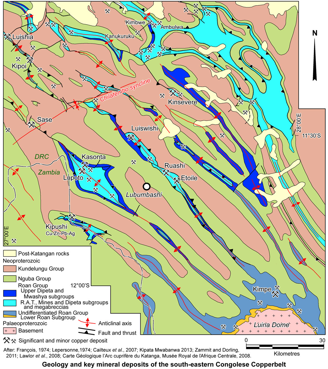
The Kolwezian event produced an outward progression of deformation styles, from low angle thrusting along undulose detachments with associated isoclinal folding over basement blocks in the Domes Region, to mainly NE verging thrust dislocated folding in the inner External Fold and Thrust Belt, an overprinting zone of later D2 Monwezian east-west strike-slip faulting (see below), then the outer zone of nappe development and stacked imbrications up to the outer margin of the main Lufilian Arc. The adjoining Foreland, is characterised by flat lying and gently undulating rocks of the upper Kundelungu Group. Allochthonous displacement progressively increases northward from the Domes Region, on the Zambian/DRC border, where the same rocks are para-autochthonous to autochthonous and not strongly thrusted or folded. Conversely, there is structural repetition, thickening and shortening of the sedimentary pile towards the basin core, in the outer half of the External Fold and Thrust Belt. On the outer margin, a string of broad windows of Roan Group megabreccias are exposed, each covering hundreds of km2 (e.g., the Kolwezi Klippe, and the 'Roan windows' at Tenke-Fungurume, below the Lake Tshangalele Tertiary basin and east of Kinsevere) before thinning drastically to the NE, into a thin autochthonous onlap sequence. Two of these, the Kolwezi Klippe and Tenke-Fungurume window, contain the largest clusters of major Cu-Co deposits in the Congolese Copperbelt. The 50 Mt @ 4% Cu Kimbwe deposit, 65 km NNE of Lubumbashi, is found in the third of these large 'Roan windows'.
On this outer margin, the autochthonous sequence is overlain by para-autochthonous and allochthonous sheets of the same succession of Roan to Kundelungu Group rocks. There are commonly eroded remnants of up to four imbricated, flat lying to shallowly dipping, gently folded plates (or clusters of plates) of those rocks in these areas, each containing different lithofacies of the same sequence (i.e., derived from different parts of the original basin). Adjacent plates in the same imbricate layer may have internal fold axes that are oriented in different directions. The geometry and distribution of the thrust and nappe plates suggests they were emplaced by a multiple stages of thrusting.
Within individual plates, the strongly internally deformed and folded allochthonous packages of RAT, Mines and Dipeta subgroup rocks are overlain by the much less deformed Mwashya Subgroup sequence.
Nappes and thrust sheets of Roan to Kundelungu group rocks are frequently thrust over either Roan megabreccia or unit Ku-2.1, the Mongwe Formation of the Kundelungu Group, comprising ~470 m of dolomitic pelites, sandstones and siltstones, indicating a maximum age for this thrusting. The succeeding ~1700 m of the Ku-2 Ngule Subgroup is composed of similar lithofacies, prior to the deposition at ~550 Ma (from the coincidence of the paleomagnetic poles of the different blocks comprising central Gondwana; Tohver et al., 2006) of the Biano Subgroup (Ku-3) molassic arkoses, conglomerates and argillaceous sandstones, taken to postdate the main Lufilian Orogeny. This implies the shallow detachment at the base of the R.A.T. Subgroup, penetrated to the surface soon after deposition of the Mongwe Formation, Ku-2.1 and transported an allochthonous plate of Roan, Nguba and basal Kundelungu groups to the NE, over an autochthonous sheet of the same rocks, during a rapid, salt facilitated, pulse of Lufilian compression.
Structural contacts associated with the Kolwezian event appear to be better defined and more regular compared the internal deformation within the megabreccias, suggesting that dissolution and removal of evaporites was advanced by this stage, with thrust planes following earlier developed detachment surfaces. However, sufficient evaporites remained to produce diapirs, emplaced in sheared anticlinal axes and thrust planes, triggered by the deformation, and by the weight of overlying Nguba and Kundelungu group sequences.
• Monwezian Tectonic Event, D2 of François (1974) and Kampunzu and Cailteux (1999), which imposed a series of generally WSW-ENE to east-west sinistral, branching, strike slip faults displacing D1 Kolwezian structures, mainly in the northern half of Lufilian Arc, where structures trend more east-west (Kampunzu and Cailteux, 1999 and references therein; e.g., the Monwezi Fault and its northern branch passing through Menda, the Kapamba-Milebi fault, and the structure passing through the Tilwezembe-Mutanda-Kisanfu deposits a little further to the north). Further east, these structures curve to be NW-SE trending (e.g., the Lupoto fault zone where the east-west trending northern Monwezi Fault branch passes through the Shinkolobwe deposit/diapir and curves to the SE passing through Sase and Lupoto).
Demesmaeker et al. (1963) and François (1974;1987) noted that Roan Group rocks commonly intrude the anticlines along the 'Monwezi' fault zones (their "failles d'extrusion"), crosscutting both the Nguba and Kundelungu groups successions on both normal and overturned limbs of the folds, which François (1987, 1993) concluded were gravity-induced diapirs.
Based on the apparent offset of deep seated magnetic markers, these structures individually have displacements of a much as 35 km, mainly in the northern half of the Lufilian Arc, where structures trend more east-west (Kampunzu and Cailteux, 1999 and references therein). Further east, these structures curve to be SE-NW trending (e.g., the Monwezi Fault and the structure passing through the Tilwezembe-Mutanda-Kisanfu deposits a little to the north). Kampunzu and Cailteux (1999) estimate that the total cumulative sinistral displacement on the series of these Monwezian faults may be as much as 130 km. This assumes the deep seated magnetic markers used represent the same feature on either side of the faults considered.
This event was part of the overall Lufilian Orogeny that persisted to ~512 Ma. Kampunzu et al. (2000) quote the youngest age of uranium in D2 faults as ~525 Ma.
• Late Orogenic Extensional Collapse, a brittle event, probably post ~530 Ma, only recorded in the Lufilian Arc (Kipata, 2013). It caused NW-SE directed extension across the whole arc, and reactivation of earlier compressional and strike-slip structures. This protracted period of post-orogenic uplift and cooling, extended to 483 Ma (Porada and Berhorst, 2000; John et al., 2004; Rainaud et al., 2005 in Master and Wendorff, 2011).
• Post-orogenic Transpressional Inversion, a NW-SE brittle transpressional inversion recorded in the Lufilian Arc also affects the Kundelungu Foreland and the fringing Kibaran, Irumide and Ubendian basement. It corresponds to the Lufilian D3 Chilatembo stage of Kampunzu and Cailteux (1999) and took place after the Lufilian extensional collapse. François (1993) suggested an age of ~305 Ma for this event. Kipata (2013) regards this as post-Lufilian, most likely Palaeozoic in age. It produced large, gentle, open, upright folds with axes varying from NNE-SSW to ENE-WSW (e.g., the ENE-WSW oriented Chilatembo syncline that cuts across the arc just NW of Kinsevere and Luiswishi), and north-south and east-west faults, low-angle thrusting of Nguba and Kundelungu group units, possibly accompanied by late salt diapirism (Kampunzu and Cailteux, 1999; Schuh et al., 2012; Kipata, 2013). This phase is responsible for much of the interference folding seen in the DRC section of the Lufilian Arc.
• Uplift, Peneplanation and Cratonisation and extension related to the Cenozoic African Rift.
The degree of metamorphism and deformation varies from a peak of chlorite (lower greenschist) in the Congolese Copperbelt, to biotite or phlogopite (upper greenschist to lower amphibolite; Ramsay and Ridgeway, 1977) in the main Zambian Copperbelt, to garnet and/or kyanite-bearing assemblages in the western Domes region of Zambia (Cosi et al., 1992; Broughton et al., 2002). These variations have been ascribed to differences in tectonic character, particularly the thin-skinned crustal exhumation and thrust stacking of basement and Katangan rocks in the Congolese Copperbelt (e.g., Porada and Berhorst, 2000).
Mineralisation
Within the DRC, the Lufilian Arc essentially comprises a northern segment that trends WSW-ENE to east-west, primarily reflection Monwezian trends, overlapping and intersecting a dominant NW-SE trend to the east that connects to the south with the NNW-SSE Zambian Copperbelt. Over this ~350 km interval, the arc comprises, in both segments, the outer zone of broad remnant klippen, or large thrust/nappe windows of Roan Group rocks and the inboard series of narrow, persistent, parallel, curvilinear anticlines described above. These structural culminations/linears, which result in the localised uplift and/or diapiric injection and exposure of discontinuous windows and slivers of Roan Group rocks through the dominant Nguba and Kundelungu groups sequences, are developed over a width of ~90 km, with as many as 5 to 8 such slivers in any one section of the arc. These two zones represent the axis of maximum tectonic activity within the External Fold and Thrust Belt of the Lufilian Arc.
While copper-cobalt occurrences and artisanal mines are developed along these Roan Group exposures over a width of ~60 km or more, the significant economic deposits delineated to date, are concentrated in two of the the outer klippen/thrust windows to the north (Kolwezi Klippe and Tenke-Fungurume Roan Window), on the NE-SW to east-west trending segment of the arc, and the next 2 to 3 structural culminations/linears (mainly Monwezian structures) to the south, over a width of ~25 km.
In the east, i.e., in the NW-SE trending segment, the significant deposits are found over a more restricted corridor, usually only occupying 1 to 3 adjacent structural culminations/linears at any one section of the belt.
Uranium-copper mineralisation tends to occur inboard of the main copper-cobalt zone (e.g., Shinkolobwe), followed further inboard again by Cu-Zn-Pb-Ag deposits (e.g., Kipushi, Lombwe and Kengere).
The localisation of significant mineralisation within these corridors is controlled by factors that include basin architecture, structure and facies, as outlined below.
• Mwashya Subgroup and Nguba Group Orebodies
The most significant deposit within these host rocks is Kamoa, located on the northwestern margin of the Katangan Basin. It has resources of >750 Mt @ >2.6% Cu, without accompanying cobalt, but an upper zone of weak zinc-lead. Mineralisation is predominantly hosted by reduced sedimentary rocks of the basal Nguba Group, overlying a condensed, oxidised, arenitic clastic suite of Mwashya Subgroup rocks.
As a consequence of the second period of rift extension that commenced during deposition of the late Dipeta Subgroup, the Katangan basin was expanded, and a broad apron of Mwashya Subgroup and overlying Nguba Group rocks were draped onto the adjacent basement Nzilo Block to the NW, directly overlying Mesoproterozoic Kibaran metasedimentary rocks. The R.A.T., Mines and Dipeta subgroups are all absent from this apron, and the resultant Mwashya Subgroup was deposited in shallow water, oxidising conditions. The succeeding Grand Conglomérat, at the base of the Nguba Group, commenced with a reduced suite of diamictite and fine clastic sedimentary rocks, that included abundant diagenetic pyrite, a potential source of sulphur to nucleate subsequent diagenetic ore precipitation. The Grand Conglomérat represents the first reduced bed over an oxidised substrate in that part of the basin.
The deposit is located immediately adjacent to the major NNE-SSW trending syndepositional fault that marked the western edge of the main Katangan basin. It separates autochthonous Mwashya Subgroup and Nguba Group hosts on the Nzilo Block, from the autochthonous to para-autochthonous Roan to Kundelungu rocks to the east, and forms the western boundary of the External Fold and Thrust Belt. Mineralisation continues east, across this fault zone. Mafic intrusive rocks and equivalent lavas within the Grand Conglomérat, are interpreted to be equivalents of the major gabbro intrusions, tuffs and lavas found elsewhere within the Lufilian Arc, and may represent a heat engine that influenced the scavenging and supply of copper. See the separate Kamoa record for more detail.
The Frontier deposit, to the south, on the eastern margin of the Kafue Anticline on the DRC-Zambian border and ~30 km SE of Mufulira, is hosted by reduced Mwashya Subgroup shales, overlain by Nguba Group Grand Conglomérat diamictite and Kakontwe Formation carbonate rocks. The Mwashya Group is para-autochthonous, and is separated from Palaeoproterozoic metamorphic basement by Upper Roan Subgroup dolostones and a condensed Lower Roan Subgroup sequence of oxidised conglomerates and arenites, without the reduced Copperbelt Orebody Member that hosts ore at Mufulira. As such, the host Mwashya Subgroup shales form the stratigraphically (and structurally) lowest reduced unit above basement in the local section. Frontier is in the DRC, but is part of the Zambian Copperbelt. Mineralisation is vein controlled, structurally concentrated as a wedge shaped body, elongated along the axis of an overturned antiformal structure. The mineralised network of veins are developed within fractured Mwashya pyritic carbonaceous shales. It has a total resource of >270 Mt @ ~1.2% Cu. See the separate Frontier record for more detail.
At the Kipoi cluster of deposits, economic mineralisation is hosted in a range of stratigraphic positions that varies from deposit to deposit. At Kipoi Central, breccia, transgressive and concordant vein ore is hosted within Mwashya Subgroup lithologies only, whilst, ~1 km to the north at Kipoi North, all of the ore is within the 'Lower Orebody' stratigraphic position within the lower Mines Subgroup. At Kileba, ~7 km to the SE of Kipoi Central, the host belongs to the Mwashya Subgroup, whilst at Judeira, 4.5 km NW of Kipoi Central, ore is contained within either Mines Subgroup, or more likely, Dipeta Subgroup lithologies. The Mwashya Subgroup dolomitic siltstones and dolostones hosts are interbedded with and overlie mafic volcanic and pyroclastic rocks, and associated thin 'iron formation' bands. The relationship of these volcanic rock and the ironstones to similar lithologies of the Kansuki Formation, previously attributed to the lower Mwashya Subgroup, but more recently to the upper Dipeta Subgroup, is uncertain. The total resources in this group of deposits amounts to ~73 Mt @ 1.3% Cu, 0.06% Co. See the separate Kipoi record for more detail.
At the small Sase Cu-Co deposit, ~24 km south of Kipoi Central, ore is principally hosted within dolostones and siliciclastic rocks that are carbonaceous, and correlated with the middle to upper Nguba Group. However, structure appears to be the predominant overall control on mineralisation, which is markedly transgressive and hosted in locations of brittle and brittle-ductile deformation. The deposit is localised in part of an east-west anastomosing fault zone that cuts across the overall NW-SE structural grain of the district and is adjacent to a small diapiric 'Roan breccia' lens. The deposit has estimated resources of ~12.5 Mt @ 1,3% Cu, 0.05% Co. See the separate Sase record for more detail.
The Kipushi Cu-Zn-Pb-Ag deposit differs from the other deposits of the Congolese Copperbelt, in that it is largely transgressive, post-dates formation of the enclosing Roan megabreccia, and contains appreciable zinc, originally containing >30 Mt @ >20% Zn, ~2% Cu, with associated Pb, Ag and Ge.
The deposit is located ~30 km WSW of Lubumbashi in the DRC, and is on the inner margin of the External Fold and Thrust Belt of the Lufilian Arc. It lies across the northern limb of a tight (60 to 80° dips), WNW-ESE trending anticline, the core of which is occupied by R1-3 megabreccia. The megabreccia is overlain by late Dipeta Subgroup siliceous and hematitic dolostone, Mwashya Subgroup dark shale, and by Grand Conglomérat diamictites, Kakontwe Formation dolostones, finely interlaminated dolostones and dolomitic siltstones of the Série Récurrente and an overlying suite of dolomitic shale, all of the Nguba Group. While the megabreccia concordantly underlies the host sequence in the core of the anticline, to the west it has replaced much of the northern limb which is terminated by the NNW trending (normal to strike) Kipushi fault that separates the remaining lithologies of the limb, from the megabreccia incursion to the west. A 600 m long, ~100 to 200 m thick écaille (the "lambeau") of the Kundelungu Group dolomitic shales (Ku-2.2), is located within the megabreccia, immediately to the west of, and within the collapse breccia of the 200 m wide Kipushi Fault, abutting the remaining limb to the east. The "lambeau" follows the fault to a depth of ~1800 m at an angle of 50 to 70°WNW.
Mineralisation at Kipushi is restricted to the Kipushi fault, and to fingers penetrating eastward into, and replacing, the Kakontwe and Série Récurrente in the remaining northern limb of the anticline. No mineralisation is developed within the "lambeau" or within the fault where it is adjacent the Grand Conglomérat, nor does it replace lithologies within the latter. The ore is developed over a length of ~500 m within the fault, over thicknesses of as much as 40 to 60 m, and follows the structure down-dip for >1800 m. Sulphides replacing the Série Récurrente and upper Kakontwe follow bedding planes for up to 180 m from the fault.
Ore occurs as i). Main Cu-Zn ore, with 20 to 30% contained metal, mainly as bornite, chalcopyrite and sphalerite, within the Kipushi fault and penetrating into the upper Kakontwe Formation; ii). Low grade Cu ore, with ~2% Cu, mainly as chalcopyrite, which is partly within the fault, but has predominantly replaced the Série Récurrente, forming irregular stratabound lenses and 'fingers'; iii). Rich Zn ore, with ~40% Zn as sphalerite, occurring as elliptical pipes of 5 to 20 m in diameter that penetrate deeply into the Kakontwe Formation dolomites, connected to the main ore, either laterally or upwards. The rich sphalerite cores are often surrounded by pyritic sheaths. See the separate Kipushi record for more detail.
• Dipeta Subgroup Orebodies
A number of significant sediment hosted copper-cobalt deposits are hosted within the Kansuki Formation, the uppermost unit of the Dipeta Subgroup, previously regarded as the Lower Mwashya Subgroup (Cailteux et al., 2007). The chief of these are the neighbouring Mutanda and Deziwa deposits, each with resources totalling >300 Mt @ >1.4% Cu and from 0.12 to 0.6% Co, which with the smaller Tilwezembe to the west, are located 25 to 40 km SE of the Kolwezi Klippe in the northern section of the Lufilian Arc. They are hosted within core of an ENE-WSW to east-west trending anticlinal lineament, the core of which is dislocated by the parallel Kansuki Fault, a major fault zone that extends for >75 km, from south west of Kolwezi in the west, to beyond the Kisanfu deposits in the east. The Kansuki Fault zone is the trace of both a D1 'Kolwezian' event north vergent thrust, and a D2 'Monwezian' event sinistral strike-slip fault (Kampunzu and Cailteux, 1999). The Kansuki Formation occurs as a string of lens like exposures in the crest of the anticline, obliquely truncated on both extremities by the Kansuki Fault.
Mutanda, Deziwa and Tilwezembe are hosted by slivers of Dipeta Subgroup rocks over a strike length of ~15 km. However, the major Kisanfu deposits, a further ~15 km to the east in the same structure, are hosted by Mines Subgroup rocks including both the regional 'Lower' and 'Upper' Orebody positions within the Kamoto and Dolomitic Shales formations, but also the 'Third Orebody' position in the Kambove Formation, immediately below the Dipeta Subgroup (see below).
At Mutanda, the Dipeta Subgroup within the east-west striking sliver, which is bounded to the north and south by faults, occurs as a relatively flat lying, but overturned sequence, with each unit separated by a low angle thrust. The host upper Kansuki Formation comprises recrystallised stromatolitic dolostone containing veinlets and disseminations of chalcocite and carrollite, and more rarely bornite. The stratigraphically lower parts of this dolostone includes intercalated, finely bedded, dolomitic argillites which contain fine disseminations and veinlets of copper and cobalt sulphides along bedding planes, with coarser disseminations of the same minerals (particularly euhedral carrollite) dispersed throughout. In the upper part of the unit, there are two distinctive and consistent marker beds: i). a persistent specular hematite band, often in close proximity to a thin jaspilite layer and ii). a more diffuse band of oolitic dolomite. Above the dolomite, there is an intermittently preserved, but locally highly mineralised, black shale layer which has only been intersected in a limited number of drill holes. The stratigraphically highest, and structurally lowest part of the unit is a chaotic breccia, interpreted to be the collapsed remnants of an original evaporite removed by hydrothermal fluids (Wimberley et al., 2011).
The host unit is structurally overlain by sedimentary rocks from lower in the Dipeta Subgroup (which includes possible a fine-grained mafic pyroclastic), and structurally underlain by the Grand Conglomérat diamictites of the Nguba Group. The contact between each of these units is occupied by a shallowly south-dipping thrust, often marked by a zone of brecciation. The steeply north dipping reverse east-west fault that bounds the mineralised sliver to the north, juxtaposes the Nguba Group Kakontwe Formation, while the southern fault superimposes more of the Grand Conglomérat diamictites.
A similar setting is indicated at both Deziwa and Tilwezembe. Although tectonic breccia are evident associated with faulting and thrusting, no Roan megabreccia is found in association with these three deposits.
Compared to the major Mines Subgroup deposits, Mutanda and Deziwa deposits are also characterised by their much greater thickness (cumulative 100 to 250 m thick, compared to cumulative 20 to 30 m in the Mines Group), but lower grade (averaging ~1.4% Cu, compared to >3.5% Cu, but similar Co levels). See the separate Mutanda, Deziwa and Tilwezembe record for more detail.
The smaller Shituru at Likasi (100 km to the ESE), on the eastern, NW-SE oriented segment of the Congolese Copperbelt, is also hosted within the Kansuki Formation. Shituru is wedged between two converging reverse faults in the core of a tight anticline, overlain by Mwashya Subgroup and Nguba Group rocks, and fault bounded by Kundelungu Group rocks, again without associated Roan megabreccias. Some mineralisation in the Kipoi district (see above, and the separate Kipoi record) may also be hosted by the Dipeta Subgroup.
These Dipeta Subgroup hosted deposits appear to be restricted to the inner (SW) margins of the main Congolese Copperbelt. Dipeta Subgroup rocks do occur elsewhere within the Copperbelt, e.g., as écailles in megabreccia in the outer parts of the Lufilian Arc, particularly in the Kolwezi Klippe and Tenke-Fungurume Roan Window, where they are barren. Similarly, no mention of mineralisation in the same unit in the core of the Copperbelt have been encountered.
The distribution of Dipeta-hosted mineralisation may correspond to the section of the Congolese Copperbelt where the underlying Mines Subgroup facies is principally characterised by algal biohermal reefs, and is mostly barren (i.e., the 'Menda' facies - see the Mineralised Facies within the Mines Subgroup section below). The conditions in this facies are not regarded as conducive to the deposition of copper mineralisation, and the first favourable reduced unit above the oxidised lower sequence in the lower Dipeta Subgroup (the "R.A.T.-like" R.G.S.), is the host Kansuki Formation at the top of the Dipeta Subgroup. Passing to the east, along the Kansuki anticlinal lineament from Mutanda, ore is found progressively lower in the sequence, first in the Kambove Formation of the Mines Subgroup, as at Kisanfu, rather than in the Kansuki Formation, and finally in the Dolomitic Shales and Kamoto Formations of the lower Mines Subgroup. This may reflect a transition to favourable lithofacies in the underlying Mines Subgroup. A similar, but more direct facies transition and progression of mineralisation to lower stratigraphic levels is obvious from Shitaru to Kambove and within the Kipoi group of deposits.
• Mines Subgroup Orebodies
The Mines Subgroup has historically been the most important host to ore. The largest deposits are located within the Kolwezi Klippe (including Écaille C, DIMA (Dikuluwe, Mashamba West & Mashamba East), KTO (Kamoto underground), KOV (Kamoto-Oliveira-Virgule), Musonoie, T-17, Dilala East and Kananga) and the Tenke-Fungurume Window (including the Kwatebala, Fwaulu, Shimbidi, Mwadinkomba, Kansalawile, Fungurume I to XI, Mambilima and Pumpi deposits). These two clusters each contained historic production + resources of >500 Mt @ >3.5% Cu, >0.3% Co, and occur in large (>150 and >400 km2 respectively) allochthonous slabs of Roan Group rocks, close to the northern and northwestern margins respectively of the External Fold and Thrust Belt of the Lufilian Arc.
Other significant deposits are found along the NW-SE trending core of the Congolese Copperbelt, but as clusters of lesser tonnage, e.g.,
Mukondo, Kakanda, Kambove, Luishia-Kasongwe, Luiswishi, Kasonto-Lupoto and Etoile-Ruashi, which mostly contain >40 Mt @ 2.8 to 4.8% Cu, 0.1 to >1% Co.
Virtually all of these deposits, which are distributed over a ~200 km interval of the Congolese Copperbelt, are stratigraphically controlled at two main stratigraphic positions. These two ore-bearing layers usually correspond to the first appearance of grey reduced rocks, immediately above the transition from red to lilac oxidised arenaceous lithologies of the R.A.T. Subgroup (R.A.T. Lilas), and sandwich a barren layer, corresponding to the pale siliceous R.S.C. unit. Mineralisation is closely linked to tidal and reef facies hosts.
The lower mineralised interval is generally 10 to 15 m thick, and ranges from the grey, strongly authigenic silty dolostones of the R.A.T. Grises, to the grey, fine-grained, laminated, argillaceous and chloritic, siliceous dolostones of the overlying D.Strat. and siliceous, finely bedded dolostones and chloritic-dolomitic siltstones of the R.S.F., the lower members of the Kamoto Formation (François and Coussement 1990, unpub.; Cailteux et al., 2005; Hitzman et al., 2012).
The lower mineralised interval is separated from the upper by the generally poorly mineralised, strongly recrystallised silicified dolostones of the R.S.C., the uppermost member of the Kamoto Formation, which is 0 to 30 m thick.
The upper mineralised interval immediately fringes the upper margin of the R.S.C. It is 5 to 10 m thick, within the two lowest members of the 30 to 100 m thick S.D., namely the 5 to 10 m thick S.D.B. (S.D.-1a) basal dolomitic shale, and the overlying ~2 m thick B.O.M.Z. (S.D.-1b) grey chloritic, dolomitic siltstone (the Black Ore Main Zone, so called because of its Mn content). Locally there are intercalations of ore bearing siltstone, up to 0.4 m thick, within the R.S.C., either near the top or at the base. Copper sulphides may also extend into overlying dark-grey to black carbonaceous metapelites (S.D.2d and S.D.3b) to form sub-economic accumulations (generally <1% Cu) and small economic deposits (locally >2% Cu; François and Coussement 1990, unpub.; Cailteux et al., 2005; Hitzman et al., 2012).
The cumulative thickness of the stratigraphic interval encompassing the orebodies, including the 'barren' R.S.C. unit, varies from 15 to 55 m, averaging ~25 to 30 m (Hitzman et al., 2012).
The lower mineralised interval is invariably more extensive than the upper, with the upper being absent in a number of areas and mines (François and Coussement 1990, unpub.).
A third mineralised interval may be represented by lenses or broad zones of mineralisation within the Lower C.M.N. (R-2.3.1) and lower sections of the Upper C.M.N. (R-2.3.2) of the Kambove Formation (Cailteux et al., 2005). Where ore occurs in this position, the mineralised intervals lower in the sequence are often poor (Pelletier,1964). Mineralisation occurs as stratabound disseminated sulphides in bodies that are 4 to 20 m thick and 10 to 100 m long, hosted in tidal and reef lithologies similar to the host rocks in the 'lower' and 'upper' orebodies (Cailteux, 1978b; 1986; 1994). François and Coussement (1990, unpub.) report that this lean disseminated mineralisation, consists of scattered chalcopyrite or carrollite, which may be easily mined and treated. Surficial weathering transforms the rock to an earthy brown colour with encrustations of malachite and black Cu, Co and Mn oxides.
This style of mineralisation is recognised at Kambove, Kambove-Ouest, Luishia-Kasongwe, Luiswishi and Etoile-Ruashi, where "considerable tonnages of this ore have been won" (François and Coussement, 1990, unpub.). Similarly, Hitzman et al. (2012) note that the Kisanfu deposits, in the northern section of the belt (east of Matunda), but closer to its core, have relatively significant amounts of mineralised Kambove Formation rocks.
The Kinsevere deposit, on the outer, or eastern margin of the Copperbelt in the south, to the east of Lubumbashi, contains mineralisation over much of the Mines Subgroup, from the D.Strat. to high in the C.M.N. units of the Kamoto, Dolomitic Shales and Kambove Formations. The Mines Subgroup facies in this section of the basin is not normally well mineralised in the Lower and Upper orebody positions, and mineralisation has spread higher into the sequence. In addition, the normally barren R.S.C. unit is absent at Kinsevere. Instead the overlying S.D. (Dolomitic Shale), which immediately overlies the D.Strat. and R.S.F., is thicker than normal, and is characterised by well bedded, black, carbonaceous, fine-grained micritic cemented clastics rocks, and hosts the bulk of the orebody. Mineralisation then continues upward into the C.M.N. This implies deeper water conditions, with the "R.S.C. reef" absent, and instead a greater thickness of black shales.
Both bedding controlled sulphide veining and a crosscutting network of quartz-carbonate-sulphide veins following fractures and joints occurs over a stratigraphic thickness of >200 m within the mineralised écailles of these lithologies that make up the Kinsevere megabreccia, to comprise >50 Mt @ >3% Cu. No information is has been encountered to indicate if the many other, largely artisanal mined deposits of this outer zone are also similarly hosted.
Uranium Mineralisation - A group of copper-uranium deposits/occurrences are distributed over an ~140 km long, interval, from east to west (Shinkolobwe, Swambo, Menda and Kalongwe), coinciding with a string of artisanal copper workings on the inner (southern) margin of the northern Congolese Copperbelt. These deposits are hosted by an irregularly developed series of anticlinal and faulted slivers of Roan Group rocks, ~10 to 25 km south the line of copper deposits that includes Mutanda. Shinkolobwe, which is on the eastern end of the trend, is 20 km SW of Kambove, and produced >40 000 t U3O8 prior to closure in 2004. The uranium mineralisation at Shinkolobwe, occurs as pockets and veins of sulphide minerals and uranium oxides, filling fractures, faults and joints within a 300 m long écaille of Mines Subgroup D.Strat., R.S.F., R.S.C. and S.D units, within an R1-3 megabreccia, in an anticlinal core, overlain by Nguba Group sedimentary rocks. The mineralisation contains high grades of Co and Ni, and lesser Cu. The other three deposits are geologically similar to Shinkolobwe.
Mineralised Facies within the Mines Subgroup - The Kamoto and Dolomitic Shales Formations that host the main 'mineralised intervals', are stratigraphically very regular across the Congolese Copperbelt, showing the same lithological succession for >350 km, from Kolwezi, to Tenke-Fungurume, Kabolela, Etoile and Lubembe (Hitzman et al., 2012 and references cited therein; Cailteux et al., 2005). However, subtle lithofacies variations across-strike, mark a progressive evolution from more near-shore (north and NE) to more reefal (south and SW) environments (François, 1973, 1974; Lefebvre, 1979; Cailteux, 1978; 1983; 1994), broadly correlating with the distribution of mineralised zones (François, 1973; 1974; 2006; Cailteux, 1983; 1994; Cailteux et al., 2005).
François (1973; 1974; 2006) recognised variations in the thickness and stromatolitic facies type of the R.S.C. unit and the ratio of subarkosic sandstone to dolomitic siltstone in the S.D. Formation to define six lithofacies, only two of which contain major ore deposits (Cailteux et al., 2005).
The northern, near-shore 'Long' and 'Kilamusembu' facies sequences are characterised by the absence of stromatolites, the occurrence of dolostone and arenites in the Dolomitic Shales Formation and of arenites in the Kambove Formation. In these two facies, the 'mineralised intervals' described above are barren (i.e., <1% Cu) or poorly mineralised, with the exception of the Tenke deposit. Between Kolwezi and Tenke, the exposed Long and Kilamusembu facies together contain 26% and 19% of Katangan Copperbelt copper and cobalt resources, respectively. They are marked by low copper grades (1.0 to 2.0 wt.% Cu) and relatively low cobalt contents (0.1 to 0.4 wt.% Co; Cailteux et al., 2005). These facies are removed from the reefal environment, characterised by clastic carbonate and basement derived siliciclastic sedimentary rocks. The Kilamusembu Facies is only found in the Kolwezi area and represents a mineralised transitional facies between barren Long and mineralised Musonoi facies (Cailteux et al., 2005). North from the Musonoi facies, it contains relatively lower grade, with the lower mineralised interval carrying 2 to 3% Cu, while the upper has 3 to 4% Cu (Cailteux et al., 2005). The host sequence at Kinsevere, which lacks reefal or reef debris facies, but instead contains a thicker shale dominated Dolomitic Shale unit may be a variant of the Kilamusembu Facies.
The 'Musonoi' and 'Kalumbwe' facies sequences are defined by: i). clasts of stromatolites; ii). stromatolites in the R.S.C.; and iii). absence of arenites in the Dolomitic Shales and Kambove Formations. The Kalumbwe facies Dolomitic Shales Formation contains no dolostones. These two facies host some of the most important Cu-Co deposits (e.g. Kamoto, Fungurume), with only a few barren or poorly mineralised zones. At these deposits, the 12 m thick lower mineralised interval of these facies may carry up to 7% Cu, while the upper, above the R.S.C., averages 6% Cu and 0.6% Co (Cailteux et al., 2005). These facies are proximal to the biohermal reef, and contain abundant reef debris and much lesser siliciclastic sedimentary rocks. Together the exposed rocks of these two facies between Kolwezi and Kakanda-Fungurume host copper-rich (>2.0 wt.% Cu) and cobalt-poor to cobalt-rich (<0.1 to 0.5 wt.% Co) ores, representing 56% and 61% of Katangan belt copper and cobalt resources, respectively.
The southernmost 'Menda' and 'Luishia' facies sequences are marked by algal biohermal reefs in the R.S.C. and in the Kambove Formation, i.e., these facies correspond to the algal biohermal reefs. The lithostratigraphic 'lower and upper mineralised intervals' within these facies are generally barren. However, sub-economic, to in some cases, well developed Cu-Co mineralisation does occur in this facies (e.g., Kambove-Ouest, Luishia and Luiswishi). In addition, other economic to sub-economic Cu-Co mineralisation in these two facies, known as the 'third orebody', is hosted 60 to 100 m above the 'upper mineralised interval', occurring within the Lower C.M.N. (R-2.3.1) and lower sections of the Upper C.M.N. (R-2.3.2) in the Kambove Formation, as described above (Cailteux et al., 2005). Where exposed, from Kalongwe (40 km SW of Kolwezi), to Shinkolobwe (20 km SW of Likasi) to Etoile (near Lubumbashi), these two facies host copper- and cobalt-rich (>2.0 wt.% Cu and 0.4 to 0.6 wt.% Co) ores and account for 18% and 20% of known Cu and Co resources respectively. Within this zone, anomalous Ni (several hundred ppm up to 0.5 wt.% Ni) is associated with Co in both facies. To the SE, between Lupoto and Lubembe, the Luishia facies host cobalt-poor (<0.1 to 0.4 wt.% Co) mineralisation (Cailteux et al., 2005).
Note: The presence and distribution of these facies on a regional scale is not universally accepted, and some recent authors (e.g., Hitzman et al., 2012) have omitted reference to them. However, locally such facies variations are evident, and are important to the distribution and grade of mineralisation.
• Hypogene Mineralisation and Alteration
The Kamoto and Dolomitic Shales Formations host rocks were subjected to a complex series of diagenetic and hydrothermal mineral growth/alteration processes, which are only broadly linked to ore formation, and largely independent of the tenor of mineralisation. Hitzman et al. (2012) detail a generalised sequence of alteration within the Kamoto Formation, and to a lesser extent the lower Dolomitic Shales Formation, as follows:
i). precipitation of diagenetic framboidal pyrite, which is subsequently either replaced by copper sulphides within orebodies, partially preserved when mantled by authigenic gangue minerals or carrollite, or preserved beyond the ore zone. Schuh et al. (2012) also attribute celestite, gypsum and anhydrite nodules at Tenke-Fungurume to early diagenesis;
ii). early potassic alteration, resulting in the formation of K feldspar in argillaceous and siliciclastic rocks;
iii). early carbonate (mainly magnesite) crystal growth in carbonate and argillaceous carbonate rocks, and Mg-chlorite in more argillaceous rocks;
iv). silicification of the host rocks through the precipitation of microcrystalline quartz, persisting well to the south of the main zone of Cu-Co deposits in barren megabreccia hosted Kamoto Formation rocks;
v). precipitation of prismatic inclusion-rich quartz ±carbonate, generally dolomite;
vi). the ore-stage precipitation of fine-grained, generally disseminated Cu-Co sulphides + quartz ±dolomite; and
vii). formation of coarse-grained, disseminated, and vein-controlled dolomite ±quartz ±Cu-Co sulphides (Oosterbosch, 1951; Bartholomé et al., 1972; François and Cailteux, 1981; Hoy, 1989; Dewaele et al., 2006; El Desouky et al., 2009, 2010; Fay and Barton, 2012).
Copper and cobalt-bearing sulphides were precipitated late in the alteration sequence, occurring as disseminated grains, generally of the same grain size as the host rock,
i). commonly following stratification (where individual mm- to cm-scale beds provide a local control on sulphide mineralogy and zoning);
ii). within modified primary porosity and secondary pore space generated by selective dissolution or replacement of carbonate, evaporite, and possibly detrital and diagenetic minerals;
iii). as apparent open-space fillings, generated by stratal collapse;
iv). within magnesite nodules with associated quartz; and
v). in bedding-parallel and oblique veinlets, some of which display distinctive fibrous textures (Bartholomé, 1974; Hoy, 1989; Cailteux et al., 2005; Dewaele et al., 2006; Fay and Barton, 2012).
Cailteux et al. (2005) summarise the sulphide paragenesis within the main deposits of the Congolese Copperbelt as follows:
Early framboidal-pyrite (pyrite-I) grains are mainly found below, above and laterally adjacent to the orebodies, sometimes with cores of chalcopyrite-I or bornite-I (Cailteux, 1974). The presence of copper in framboidal pyrite-I was confirmed by microprobe analyses, which also showed Co-Ni rich pyrite-II outer rims to pyrite-I grains (e.g. at Kamoto - Bartholomé et al., 1971; Musoshi - Cailteux, 1974; and Kinsenda - Ngoyi and Dejonghe, 1997). The general parageneses is pyrite-1 (Co, Ni rich), pyrite-II (bravoite i.e., (Fe,Ni,Co)S2) and pyrite- III, which occur in concentric zones at Luiswishi (Loris, 1996; Loris et al., 2002). Framboidal and small isolated grains of pyrite (I, II, III) are found as inclusions in diagenetic quartz and dolomite, e.g. at Kamoto (Bartholomé et al., 1971) and Kambove Ouest (Cailteux, 1983).
Primary chalcopyrite-II and bornite -II are the principal copper sulphides in the orebodies (e.g. Kambove Ouest), growing together as separate or coalescing grains. Carrollite and pyrite-III coexist with copper sulphides-II (mainly chalcopyrite). Chalcopyrite-II surrounds framboidal pyrite-I (e.g. at Kinsenda; Ngoyi and Dejonghe, 1997). Bornite-II replaces both pyrite-I and -II), e.g. at Kamoto (Bartholomé et al., 1972), where carrollite grains include well-preserved aligned pyrite-I and/or II, whilst pyrite grains outside of the carrollite have been completely replaced by bornite-II. Textural relations suggest bornite-II grew after the development of carrollite grains. At Luiswishi, copper sulphides-II and sulphides of the linnaeite group (linnaeite-siegenite-carrollite/polydymite) formed after the pyrite group (pyrite-cattierite-vaesite; Loris, 1996; Loris et al., 2002).
Sulphides-II grains (pyrite, chalcopyrite and bornite) enclose inclusions of both diagenetic gangue minerals (chlorite, dolomite, quartz) and disseminated copper sulphides-II, indicating late-stage formation of these sulphide grains. Pyrite-III rims copper sulphides-II, and bornite-II grains include digenite in bornite-dominant beds (Cailteux, 1986).
Carrollite grains include bornite-II in their core. and digenite-II towards the rim. This indicates that carrollite grew both before and after the conversion of bornite into digenite. Replacement carrollite forms an external rim over chalcopyrite and/or bornite (-II or -III) grains. The transition between carrollite rims and chalcopyrite or bornite cores is marked by a digenite fringe, whilst small pyrite grains occur within the carrollite rims.
Pyrite-III and -IV, and chalcopyrite and bornite-IV overgrow all of the above. Some carrollite grains include and partially replace copper sulphides, whilst others contain microfractures filled by chalcopyrite or bornite-IV.
In a study of the Luiswishi and Kamoto (Kolwezi) Mines Subgroup deposits, El Desouky et al. (2010) distinguished two main hypogene Cu-Co sulphide mineralisation stages and associated gangue minerals (dolomite and quartz) following the diagentic pyrite. The first is diagenetic and typically stratiform, with fine- to medium-grained sulphides that occur as disseminations, small nodules and thin, discontinuous layers, whereas the second occurs as multistage, synorogenic, stratabound, coarse-grained sulphide minerals that include chalcopyrite, bornite, chalcocite and carrollite, in veins, breccia cements and nodules with varying shapes (Van Wilderode et al., 2014 and sources quoted therein), accompanied by several generations of coarse grained silica and dolomite. See the fluid inclusions section below for salinities and temperatures for the fluids responsible for these two stages of mineralisation.
The main hypogene Cu-Co sulphide minerals in both stages are chalcopyrite, bornite, carrollite and chalcocite. In many places, this assemblage is replaced by supergene sulphides (e.g., digenite and covellite), especially near surface, and are completely oxidised in the weathered superficial zone to malachite, heterogenite, chrysocolla and azurite.
They also found at these two deposits, the hypogene sulphides of the first Cu-Co stage display δ34S values (-10.3 to +3.1‰ V-CDT) that partially overlap δ34S signatures of framboidal pyrite (-28.7 to +4.2‰ V-CDT) and have Δ34S SO4-sulphides in the range of 14.4 to 27.8‰. This fractionation is consistent with bacterial sulphate reduction. They also found carbon (-9.9 to -1.4‰ V-PDB) and oxygen (-14.3 to -7.7‰ V-PDB) isotope signatures from dolomites associated with the same stage, agree with the interpretation that these dolomites are by-products of bacterial sulphate reduction.
El Desouky et al. (2010) also found that hypogene sulphides of the second Cu-Co stage display δ34S signatures that are either similar (-13.1 to +5.2‰ V-CDT) to the δ34S values of the sulphides of the first Cu-Co stage, or are comparable (+18.6 to +21.0‰ V-CDT) to the δ34S of Neoproterozoic seawater. This, they conclude, indicates the sulphides of the second stage obtained their sulphur by both remobilisation from early diagenetic sulphides and from thermochemical sulphate reduction. The carbon (-8.6 to +0.3‰ V-PDB) and oxygen (-24.0 to -10.3‰ V-PDB) isotope signatures of dolomites associated with this second stage, are mostly similar to the δ13C (-7.1 to +1.3‰ V-PDB) and δ18O (-14.5 to -7.2‰ V-PDB) of the host rock and of the dolomites of the first Cu-Co stage. They interpret this to indicate the dolomites of the second Cu-Co stage precipitated from a high-temperature, host rock-buffered fluid, possibly under the influence of thermochemical sulphate reduction.
In addition, they found that the radiogenic Sr isotope signatures (0.70987 to 0.73576) of dolomites associated with the first stage Cu-Co mineralisation show a good correspondence with those of the granitic basement rocks at an age of ~816 Ma, indicating the mineralising fluid responsible for this stage, most likely leached radiogenic Sr and by inference, Cu-Co metals by interaction with the underlying basement rocks and/or with arenitic sedimentary rocks derived from that basement. In contrast, the Sr isotope signatures (0.70883 to 0.71215) of the dolomites associated with the second stage, show a good correspondence with the 87Sr/86Sr ratios (0.70723 to 0.70927) of poorly mineralised/barren host rocks at ~590 Ma, suggesting the fluid of the second Cu-Co stage may not have introduced additional metals from the basement rocks, but interacted with the country rocks and remobilised previously introduced Cu-Co.
These conclusions on the origin of metals were supported by the Sr/Nd analyses by Van Wilderode et al. (2014) who studied a range of samples from Kamoto, Luiswishi, Kambove West, Dikulushi and Kipushi. They concluded that the mineralising fluid of diagenetic stratabound Cu-Co mineralisation interacted with felsic basement rocks underlying the region, whilst the syn-orogenic, stratabound Cu-Co mineralisation resulted mainly from remobilisation of diagenetic sulphides, with a limited, renewed contribution of metals from felsic basement rocks.
Copper sulphides within the individual deposits show a crude vertical zonation, starting with chalcocite-digenite-bornite at the bottom, or source direction of ore metals, followed by bornite-chalcopyrite and chalcopyrite-dominant zones, and pyrite at the top e.g., the Kamoto deposit is characterised by chalcocite-digenite-bornite in the lower orebody (R.A.T. Grises, D. Strat., R.S.F.) and in the S.D.B., with chalcopyrite and minor bornite in the B.O.M.Z., chalcopyrite-pyrite in S.D.2a and pyrite in S.D.2b (Oosterbosch, 1962; Bartholome, 1962; 1963; 1969). Laterally, beyond the orebodies, framboidal pyrite is common, sometimes coexisting with a minor chalcopyrite. However, this pattern may vary from deposit to deposit, e.g., at Etoile, there are two chalcocite to bornite cycles, one from the R.A.T. Grises to D. Strat., the other from the R.S.F. to S.D.B. (Lefebvre and Cailteux, 1975), whilst at the Kambove-Ouest deposit, chalcopyrite is dominant in the R.A.T. Grises and top of the S.D.B, sandwiching a chalcocite-digenite-bornite zone in the D. Strat., R.S.F. and base of the S.D.B, either side of the R.S.C. (Cailteux, 1983, 1986).
The distribution of the Lower and Upper orebody positions within reduced rocks on either margin of the pale, highly altered, originally coarsely permeable reefal R.S.C., suggests the latter acted, at least in part, as a conduit to mineralising fluids which reacted with the enclosing favourable host rocks to form ore. Fluids would also have been transmitted through the underlying oxidised R.A.T. to also mineralise the D. Strat. hosting the better developed Lower orebody position.
Above the upper mineralised interval, and laterally beyond the limits of ore, distal from the ore fluids, pyrite becomes the most important sulphide.
There is a distinct association of carrollite (and in some cases, chalcocite) adjacent to and within the intervening R.S.C.. Carrollite generally predates chalcopyrite, bornite and chalcocite, with the highest Co:Cu ratios in the upper part of the orebodies.
Grains of Cu-poor sulphides are usually progressively rimmed by more Cu-rich varieties, reflecting the top to bottom vertical zonation within the deposit, although local reversals suggest overlapping zonation patterns, in space and probably in time. At some deposits, e.g., Kamoto and Luiswishi, two distinct stages of ore sulphides are evident: i). an early, fine-grained stage characterised by lenticular, pre-lithification nodules and ii). a later, coarse-grained stage with post-lithification, locally discordant nodules and veins (El Desouky et al., 2009, 2010).
According to François (1974) and Bartholome, et al., (1971), there is an inverse relationship between the amount of carbon and Cu-Co mineralisation within an ore bed. Beds rich in carbon, contain pyrite and lesser chalcopyrite, but not chalcocite or bornite, while there is a low content of carbon within the laterally equivalent ore zones. This suggests that carbon is consumed in the alteration process involving reduction of Cu-rich chloride brines, oxidation of anhydrite and production of sulphides and carbonate gangue, as suggested in the Zambian Copperbelt (see the separate Zambian Copperbelt record).
A continuous radiometric anomaly, some tens of centimetres thick, occurs at the base of the lower mineralised interval (within the R.A.T. Grises), in many deposits, containing 60 to 400 ppm U3O8, commonly with accompanying Au, Pt, Pd, REE, V, Se and Mo. Local alluvial accumulations of Au, Pt, Pd and REE are found in the vicinity of many of the major orebodies of the Congolese Copperbelt.
Not all Mines Subgroup blocks within megabreccias are economically mineralised, with ore grade accumulations in a given block being immediately juxtaposed with poorly mineralised or barren (e.g., Tenke-Fungurume; Schuh et al., 2012). Mineralisation is abruptly interrupted by the faults and barren silty matrix that delimit the écailles/blocks of the megabreccias. This and other observations suggests that mineralisation and alteration predated significant dismemberment of the Mines Subgroup stratigraphy and formation of the megabreccias (Demesmaeker et al., 1963; François, 1973; Cailteux, 1994; Cailteux et al., 2005).
• Fluid inclusions
A number of fluid inclusion studies have been undertaken at deposits within the DRC, both in the Lufilian Arc and the Kundelungu Gulf Foreland, as follows:
• Kamoto (Kolwezi) - an unmineralised cherty dolomite layer of the Mines Subgroup within the orebody area indicated that solutions reached temperatures of 200°C at salinities of 40 wt.% NaCl equiv. (Pirmolin, 1970);
• Kamoto and Luiswishi - El Desouky et al. (2009) recognised 2 fluid groups from inclusions in a series of samples from these two deposits.The first is related to fine-grained pre-folding diagenetic ore at temperatures of 115 to ≤220°C and salinities of 11.3 to 20.9 wt.% NaCl equiv., and a second, related to coarser-grained, post-folding sulphides at temperatures of 270 to 385°C and salinities of 35 to 45.5 wt.% NaCl equiv. Type 1 samples were from fine authigenic quartz associated with dolomite and disseminated and nodular Cu-Co sulphides, while type 2 were from quartz veins cutting late Cu-Co mineralisation.
• Kamoto, Kambove and Shinkolobwe - fluid inclusions from dolomite within the orebody areas contained CO2 and CH4 in the gaseous phases. Aqueous phases were highly saline with >60 wt.% NaCl equiv., comprising Na, K, Ca, Mg-sulphates, with phosphates, carbonates and chlorides (Audeoud, 1982).
• Musonoi and Kamoto (Kolwezi) - H2O-NaCl fluid inclusions from authigenic quartz associated with stratabound mineralisation have minimum trapping temperatures between 80 and 192°C, and salinities between 8.4 and 18.4 wt.% NaCl equiv.. Samples were taken from the R.S.F. Formation and B.O.M.Z. (Dolomitic Shales Formation) at Musonoi and R.S.C. at Kamoto (Dewaele et al., 2006).
• Kipushi - fluid inclusions representative of Pb-Zn mineralising fluids have high homogenisation temperatures of ~300°C, which has been dated at ~450 Ma, (Schneider et al., 2007), and post-dates stratabound copper (Kampunzu et al., 1998).
• Dikulushi - in the Kundelungu Gulf Foreland, to the NE of the Lufilian Arc. Early Zn-Pb-Fe-Cu-As fluids were highly saline, with Ca-Na-Cl at temperatures of 135 to 172°C, whilst later-stage Cu-Ag mineralisation was found to result from an intermediate saline NaCl-H2O fluid at lower temperatures of 46 to 82°C). These fluids were found in sphalerite, dolomite, quartz, barite and calcite (Dewaele et al., 2006).
• Geochronology of ore
The following age datings relate to the formation of ore within the Congolese Copperbelt:
- Kamoto - 582±15 Ma (U-Pb dating of uraninite from U-Cu-Co ore); and 520±20 Ma (U-Pb dating of uraninite from U-Cu-Pb ore) - Cahen et al. (1971) and references therein;
- Monwezi - 602 Ma (U-Pb dating of uraninite from U ore) - Cahen et al. (1984);
- Shinkolobwe - 670±20 Ma and 620±20 Ma (U-Pb dating of uraninite from U-Mo-Co-Ni-Cu ore) - Cahen et al. (1971) and references therein;
- Kambove - 555±10 Ma (U-Pb dating of uraninite from U-Co-Cu-Ag ore) - Cahen et al. (1971) and references therein;
- Luishia - 620±20 Ma (U-Pb dating of uraninite from U ore) - Cahen et al. (1971) and references therein;
- Luiswishi - 625±5 Ma (U-Pb dating of uraninite from U-Mo-Ni-Co-Cu ore); 530±0.9 Ma (U-Pb dating of uraninite from U-Mo-Pb ore) - Loris et al. (1997).
All of these datings are for uranium, which was added late to the mineralised systems of the Congolese Copperbelt and hence do not provide much insight into the age of Cu-Co mineralisation, other than a minimum.
Late Pb-Zn-Cu-Ag mineralisation at Kipushi within the inner External Fold and Thrust Belt, has been dated at 451.1±5 and 450.5±5 Ma (Rb-Sr and Re-Os dating of sulphides from drill core; Schneider et al., 2007).
• Secondary Mineralisation
The Congolese orebodies has undergone supergene enrichment, probably during humid weathering in the Tertiary (Decrée et al., 2010; De Putter et al., 2010), and much of the ore mined to date in the DRC has been high grade secondary mineralisation. The principal secondary minerals are carbonates, secondary sulphides, silicates and oxides, including malachite, azurite, chrysocolla and chalcocite, with cuprite and native Cu being of lesser importance. Chalcocite-malachite, and locally chrysocolla, are most abundant near surface, passing downward into secondary enriched chalcocite and bornite with subordinate covellite.
Near-surface grades in well mineralised blocks within the megabreccia commonly average between 4 and 6% Cu, whereas deeper, less oxidised intersections average ~3% Cu. Leached Cu caps are locally developed, but Co is less mobile than Cu and commonly forms near-surface high-grade zones (Fay and Barton, 2012).
The zone of oxidation is very variable, ranging from as little as a few metres, to as much as 300 to 400 m below the surface, whilst indications of oxidation to limonite and the presence of native Cu has been found at 900 m at Tenke-Fungurume. The depth of oxidation is strongly influenced by topography, as the mineralised units often occur as ridges which may be from 100 to 200 m above the surrounding countryside, as at Fungurume.
In general, the uppermost few metres are totally leached and barren (François 1974) and at Fungurume in the ".. undisturbed outcrop, the ore zones appear to be totally devoid of any significant mineralisation, particularly in the higher ground" (Schuh et al., 1012). As carbonate minerals are ubiquitous in the host rock, complete leaching is unlikely, except near surface where carbonates have been completely removed. Carbonates will buffer any acidic cupriferous solution that dissolves copper from a weathered sulphide, re-precipitating it as Cu oxides/carbonates with minimal vertical transport.
The near surface leached layer is followed by a narrow zone of black Co (heterogenite) in a siliceous clay gangue, then a zone dominated by Cu carbonates and silicates, and heterogenite, in a siliceous clay gangue, which may extend to around 100 m. This is underlain by a zone containing malachite, heterogenite, copper silicates, cobalt carbonate and traces of copper sulphide minerals in a dolomitic gangue. Towards the overlying zone, the dolomite in the gangue of this zone is completely removed to form the siliceous gangue of the overlying zone. The chalcocite of the underlying zone breaks down and copper is re-precipitated as malachite and chrysocolla. This zone is underlain by a mixed zone with copper sulphide minerals, malachite and heterogenite in dolomitic gangue, which may be replaced by a narrower interval of cuprite and native Cu at the main transition from carbonates and silicates to secondary sulphides. Below this, chalcocite, bornite and lesser covellite are found, passing down into primary sulphides, mainly chalcopyrite-bornite-carrollite. The limits of these zones is extremely variable with adjacent zones of unaltered sulphide immediately adjoining heavy secondary mineralisation (Zientek et al., 2014; Hitzman et al., 2012).
The secondary mineralisation is developed both, overprinting the overlying primary mineralisation, and can be found along ridges in the central part of thrust sheets,
along their margins and along faults within the thrust sheets (Dewaele et al., 2006).
The R.S.C., which usually forms the barren core to the primary mineralisation, may also act as a conduit to secondary enrichment as the dolomite is removed by dissolution to produce a porous siliceous rock allowing the vertical access of supergene fluids. This is particularly the case case where the host écailles are steeply dipping. It leads to the R.S.C. being mineralised, connecting the Upper and Lower orebody positions as a single high grade orebody.
• Exotic Mineralisation
In addition to the supergene mineralisation that has progressed vertically and overprinted hypogene sulphides, in places there has been considerable lateral migration of metals over distances of several tens of metres of stratigraphy into the adjacent units, mainly the R.A.T. Grises, upper S.D. and the C.M.N. Frequently, the exotic mineralisation is developed below the Mines Subgroup in the R.A.T. and R.A.T. Breccia. In some cases, where megabreccia and the carbonates of the Mwashia, Nguba and Middle Kundelungu Groups are juxtaposed below the primary ore zone, these are also mineralised. This results in mineable widths which are commonly 40 m or more. Secondary Cu-Co mineralisation is also commonly deposited within fractures and cavities in the R.S.C., in places resulting in the ore being continuous between the two main mineralised intervals.
Exotic mineralisation is also found along fractures or faults that formed pathways for remobilised fluids which leached primary mineralisation and redeposited Cu carbonates, oxides and sulphides in receptive Roan, Nguba or Kundelungu strata distal from the original source (Dewaele et al., 2006).
The exotic mineralisation within intensely brecciated and porous sandstones and dolomitic sandstones of the R.A.T. Breccia at Mutoshi in the Kolwezi Klippe contained over 45 Mt @ 1.75% Cu. See the Kolwezi District record for more detail.
Timing, Origin and Discussion
See the same heading in the Central African Copperbelt - Zambian Copperbelt record which covers both the Zambian and Congolese sections of the Central African Copperbelt.
The most recent source geological information used to prepare this decription was dated: 2014.
Record last updated: 20/2/2015
This description is a summary from published sources, the chief of which are listed below.
© Copyright Porter GeoConsultancy Pty Ltd. Unauthorised copying, reproduction, storage or dissemination prohibited.
|
|
|
|
|
Basson, I.J., McCall, M.-J., Koegelenberg, C.K. and Jakaite, L. 2023 - Emplacement and preservation of mineralized ecaille within Roan Breccia of the Lufilian Arc, Central African Copperbelt: the Thrust Belt Boudinage model: in Mineralium Deposita, v.58, pp. 511-529.
|
Batumike Mwandulo, J., Kampunzu, A.B. and Cailteux, J.H., 2006 - Petrology and geochemistry of the Neoproterozoic Nguba and Kundelungu Groups, Katangan Supergroup, southeast Congo: Implications for provenance, paleoweathering and geotectonic setting: in J. of African Earth Sciences v.44, pp. 97-115.
|
Cailteux J H, 1994 - Lithostratigraphy of the Neoproterozoic Shaba-type (Zaire) Roan Supergroup and metallogenesis of associated stratiform mineralization: in J. of African Earth Sciences v.19 pp. 279-301
|
Cailteux J L H, Kampunzu A B and Lerouge C, 2007 - The Neoproterozoic Mwashya-Kansuki sedimentary rock succession in the central African Copperbelt, its Cu-Co mineralisation, and regional correlations: in Gondwana Research v.11 pp. 414-431
|
Cailteux J L H, Kampunzu A B H and Batumike M J, 2005 - Lithostratigraphic position and petrographic characteristics of R.A.T. ( Roches Argilo-Talqueuses ) Subgroup, Neoproterozoic Katangan Belt (Congo): in J. of African Earth Sciences v42 pp 82-94
|
Cailteux J L H, Kampunzu A B, Lerouge C, Kaputo A K and Milesi J P, 2005 - Genesis of sediment-hosted stratiform copper-cobalt deposits, Central African Copperbelt: in J. of African Earth Sciences v42 pp 134-158
|
Dewaele, S., Muchez, Ph., Vets, J., Fernandez-Alonzo, M. and Tack. L., 2006 - Multiphase origin of the Cu-Co ore deposits in the western part of the Lufilian fold-and-thrust belt, Katanga (Democratic Republic of Congo) : in J. of African Earth Sciences v.46, pp. 455-469.
|
El Desouky H A, Muchez P, Boyce A J, Schneider J, Cailteux J L H, Dewaele S and von Quadt A, 2010 - Genesis of sediment-hosted stratiform copper-cobalt mineralization at Luiswishi and Kamoto, Katanga Copperbelt (Democratic Republic of Congo): in Mineralium Deposita v.45 pp. 735-763
|
El Desouky, H.A., Muchez, P. and Cailteux, J., 2009 - Two Cu-Co sulfide phases and contrasting fluid systems in the Katanga Copperbelt, Democratic Republic of Congo: in Ore Geology Reviews v.36, pp. 315-332.
|
Fay, I. and Barton, M.D., 2012 - Alteration and ore distribution in the Proterozoic Mines Series, Tenke-Fungurume Cu-Co district, Democratic Republic of Congo: in Mineralium Deposita v.47, pp. 501-519.
|
Haest, M., Muchez, P., Dewaele, S., Boyce, A.J., von Quadt, A. and Schneider, J., 2009 - Petrographic, fluid inclusion and isotopic study of the Dikulushi Cu-Ag deposit, Katanga (D.R.C.): implications for exploration: in Mineralium Deposita v.44, pp. 505-522.
|
Hitzman M W, Kirkham R, Broughton D, Thorson J and Selley D, 2005 - The sediment-hosted stratiform copper ore system: in Hedenquist J W, Thompson J F H, Goldfarb R J and Richards J P (Eds.), 2005 Economic Geology 100th Anniversary Volume, Society of Economic Geologists, Denver, pp. 609-642
|
Hitzman, M.W., Broughton, D., Selley, D., Woodhead, J., Wood, D. and Bull, S., 2012 - The Central African Copperbelt: Diverse Stratigraphic, Structural, and Temporal Settings in the Worlds Largest Sedimentary Copper District: in Hedenquist, J.W., Harris, M. and Camus, F., 2012 Geology and Genesis of Major Copper Deposits and Districts of the World - A tribute to Richard H Sillitoe Society of Economic Geologists Special Publication 16, pp. 487-514.
|
Jackson M P A, Warin O N, Woad G M and Hudec M R, 2003 - Neoproterozoic allochthonous salt tectonics during the Lufilian orogeny in the Katangan Copperbelt, central Africa: in GSA Bulletin v.115 pp. 314-330
|
Kampunzu A B and Cailteux J L H, 1999 - Tectonic Evolution of the Lufilian Arc (Central Africa Copper Belt) During Neoproterozoic Pan African Orogenesis: in Gondwana Research v.2 pp. 401-421
|
Kampunzu, A.B., Cailteux, J.L.H., Moine, B. and Loris, H.N.B.T., 2005 - Geochemical characterisation, provenance, source and depositional environment of Roches Argilo-Talqueuses (RAT) and Mines Subgroups sedimentary rocks in the Neoproterozoic Katangan Belt (Congo): Lithostratigraphic implications: in J. of African Earth Sciences v.42, pp. 119-133.
|
Lerouge C, Cailteux J, Kampunzu A B, Milesi J P and Flehoc C, 2005 - Sulphur isotope constraints on formation conditions of the Luiswishi ore deposit, Democratic Republic of Congo (DRC): in J. of African Earth Sciences v.42 pp. 173-182
|
Mambwe, P., Delpomdor, F., Lavoie, S., Mukonki, P., Batumike, J. and Muchez, P., 2020 - Sedimentary evolution and stratigraphy of the ~765-740 Ma Kansuki-Mwashya platform succession in the Tenke-Fungurume Mining District, Democratic Republic of the Congo: in Geologica Belgica, v.23, 1-2, pp. 69-85.
|
Master S, Rainaud C, Armstrong R A, Philips D and Robb L J, 2005 - Provenance ages of the Neoproterozoic Katanga Supergroup (Central African Copperbelt), with implications for basin evolution: in J. of African Earth Sciences v.42 pp. 41-60
|
Muchez, Ph., Vanderhaeghen, P., El Desouky, H., Schneider, J., Boyce, A., Dewaele, S. and Cailteux, J., 2008 - Anhydrite pseudomorphs and the origin of stratiform Cu-Co ores in the Katangan Copperbelt (Democratic Republic of Congo): in Mineralium Deposita v.43, pp. 575-589.
|
Porada H and Berhorst V, 2000 - Towards a new understanding of the Neoproterozoic-Early Palaeozoic Lufilian and northern Zambezi Belts in Zambia and the Democratic Republic of Congo: in J. of African Earth Sciences v.30 pp. 727-771
|
Rainaud C, Master S, Armstrong R A and Robb L J, 2005 - Geochronology and nature of the Palaeoproterozoic basement in the Central African Copperbelt (Zambia and the Democratic Republic of Congo), with regional implications: in J. of African Earth Sciences v.42 pp. 1-31
|
Rainaud C, Master S, Armstrong R A and Robb L J, 2003 - A cryptic Mesoarchaean terrane in the basement to the Central African Copperbelt: in Journal of the Geological Society, London v.160 pp 11-14
|
Rainaud C, Master S, Armstrong R A, Phillips D and Robb L J, 2005 - Monazite U-Pb dating and 40Ar-39Ar thermochronology of metamorphic events in the Central African Copperbelt during the Pan-African Lufilian Orogeny: in J. of African Earth Sciences v.42 pp. 183-199
|
Schuh, W., Leveille, R.A., Fay, I. and North, R., 2012 - Geology of the Tenke-Fungurume Sediment-Hosted Strata-Bound Copper-Cobalt District, Katanga, Democratic Republic of Congo: in Hedenquist, J.W., Harris, M. and Camus, F., 2012 Geology and Genesis of Major Copper Deposits and Districts of the World - A tribute to Richard H Sillitoe, Society of Economic Geologists Special Publication 16, pp. 269-301.
|
Squire, R.J. and Keays, R.R., 2024 - The role of supermountain belts and climatic controls on the genesis of copper deposits in the Kupferschiefer and the Central African Copperbelt: in Mineralium Deposita v.59, pp. 717-732.
|
Zientek M L, Hayes T S and Hammarstrom J M 2013 - Overview of a New Descriptive Model for Sediment- Hosted Stratabound Copper Deposits: in Zientek M L, Hammarstrom J M and Johnson K M, 2013 Descriptive Models, Grade-Tonnage Relations, and Databases for the Assessment of Sediment-Hosted Copper Deposits - With Emphasis on Deposits in the Central African Copperbelt, Democratic Republic of the Congo and Zambia USGS Scientific Investigations, Report 2010-5090-J pp. 2-16
|
|
Porter GeoConsultancy Pty Ltd (PorterGeo) provides access to this database at no charge. It is largely based on scientific papers and reports in the public domain, and was current when the sources consulted were published. While PorterGeo endeavour to ensure the information was accurate at the time of compilation and subsequent updating, PorterGeo, its employees and servants: i). do not warrant, or make any representation regarding the use, or results of the use of the information contained herein as to its correctness, accuracy, currency, or otherwise; and ii). expressly disclaim all liability or responsibility to any person using the information or conclusions contained herein.
|
Top | Search Again | PGC Home | Terms & Conditions
|
|


