|
Lumwana - Malundwe, Chimiwungo, Lubwe |
|
|
Zambia |
| Main commodities:
Cu Co U
|
|
 |
|
|
 |
Super Porphyry Cu and Au


|
IOCG Deposits - 70 papers
|
All papers now Open Access.
Available as Full Text for direct download or on request. |
|
|
The Lumwana Project, which comprises the Malundwe and Chimiwungo deposits that are ~7 km apart, is located in the North West province of Zambia, 220 km west of the main Zambian Copper Belt mine complexes, and 60 km WSW of the town of Solwezi. The project also includes the undeveloped Lubwe deposit (Malundwe - #Location: 12° 14' 11"S, 25° 48' 47"E).
Regional Setting
For details of the regional setting of Lumwana, the Central African/Zambian Copper Belt and the Lufilian Arc, see the separate Zambian Copperbelt record.
The two main deposits at Lumwana are hosted by highly sheared amphibolite facies schists to gneisses within the north-eastern lobe of the Mwombezhi Dome, a north-east trending, ~20 x 70 km, basement dome in the western arm of the Neoproterozoic Lufilian Arc. The Lufilian Arc is a major, 900 km long, arcuate (northeast to southeast trending, convex to the north) orogenic, Pan-African fold-thrust belt, deformed during the late Neoproterozoic to early Palaeozoic. It is characterised by broadly north-directed thrust structures and antiformal basement inliers or domes, surrounded by Neoproterozoic Katangan Supergroup metasediments, which host the Central African and Zambian Copper Belts. The Lufilian Arc is flanked to the northwest by both the Archaean to Palaeoproterozoic Kasai Shield and the Mesoproterozoic (1.4 to 1.1 Ga), northeast-trending Kibaran Fold Belt (amalgamated into the Proterozoic Congo craton by the Neoproterozoic). To the southeast, it is truncated by the northeast trending Kibaran age Irumide Belt and to the south by the continental scale, ENE-trending, Mwembeshi Shear Zone.
The Lufilian Arc marks the northeastern termination of the 2000 km long, northeast-southwest elongated Damara-Katanga Belt that extends to the Atlantic coast in Namibia. Overall, the Lufilian Arc is composed of four arcuate zones. (1) the External fold and thrust belt to the northeast, that encompasses the Central African Copper Belt, characterised by thin-skinned deformation and general lack of exposed basement; (2) the Domes region, which includes the Mwombezhi Dome and Lumwana deposits, as well as the Konkola Dome, Kafue Anticline and main Zambian Copper Belt mines, representing a thicker skinned deformation with exposed basement domes; (3) the Synclinorial belt, a thicker, basinal, folded sequence, without exposed basement; and (5) the more stable Katanga High to the southwest.
Five phases of deformation are recognised in the Lufilian Arc, namely: D1 - Early Lufilian, north-south compression resulting in nappes, pervasive layer parallel S1 foliation, D1 shear zones and L1 stretching lineation. D2 - Mid-Lufilian, east-west compression induced recumbent folds with local axial plane S2 foliation, and the D2 shear zones that produced the thrusted tectono-stratigraphy; D3 - Mid-Lufilian NW-SE compression producing listric, thin-skin thrusting and folding of the Katangan metasedimentary cover rocks, and retrograde metamorphism; D4 - Late Lufilian NNW-SSE compression that produced conical, upright, open folds, crenulation and fracture cleavages and the regional domes (e.g., the Mwombezhi Dome); D5 - Post-Lufilian relaxation and post-compression unroofing with steep NW-SE, and north-south brittle normal faults and late felsic anorogenic stocks.
Local Geology
The Mwombezhi Dome contains a number of layer parallel shear zones within an east-verging major recumbent fold, forming a complex antiformal thrust stack that consists of tectonically interleaved slices of Palaeoproterozoic (Eburnian, 2.0 to 1.8 Ga) basement, overlain on their margins by Katangan Supergroup rocks, separated by a major décollement. The décollement, which surrounds much of the basement dome and separates it from the Katangan sequence, consists of intensely sheared muscovite-quartz+talc+hematite+kyanite schist containing, generally at the structural top, semi-continuous lenses of resistive, kyanite-bearing, hematitic and variably micaceous and carbonate-bearing high magnesian quartzite that grade to white schist at the contact with the basement, and is known as the "Rimming Quartzite". This décollement, which is marked by an L-S tectonite with an intense north-south mineral lineation, separates the Palaeoproterozoic thrust stratigraphy from the thin-skinned regime of the Katangan sedimentary rocks. The "Rimming Quartzite" has been interpreted to possibly represent metamorphosed Roan Group sedimentary rocks (Nisbett, 2005), although its rare geochemical composition indicates a metasomatic origin (Bernau, 2007; Moore et al., 2012).
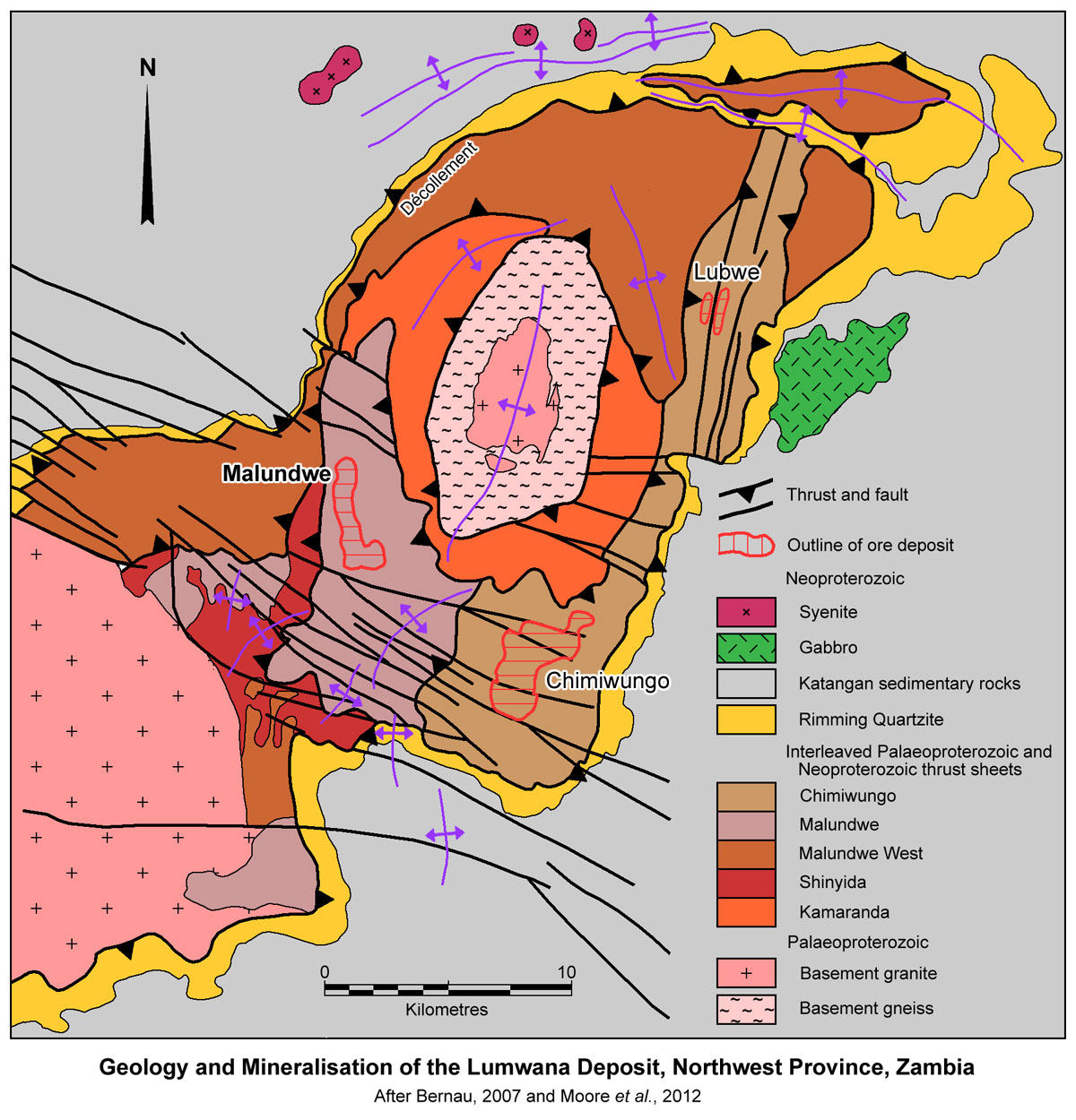 The older rocks of the dome basement comprise biotite-feldspar gneiss, hornblende gneiss, granite-gneiss, migmatites and schist. These are intruded by less deformed, younger granites (possibly correlatable with the ~880 Ma Nchanga Red Granite in the Zambian Copper Belt or the ~560 Ma Hook granite to the south in the Katanga High), mainly in the core of the dome. Talc-kyanite schist assemblages in the dome basement rocks indicate peak metamorphism of 750±25°C and 13±1 kb, corresponding to burial depths of ~50 km. Monazites from these assemblages suggest peak metamorphism at 524±3 Ma and 532±2 Ma. Rocks within the Mwombezhi Dome have been dated at between 1.88 and 1.70 Ga (Bernau, 2007).
A number of Katangan units have been structurally interleaved within the basement, below the décollement, occurring as tectono-stratigraphic sheets that have been thrust over two central cores of the Mwombezhi Dome. Within the Lumwana project area, these Katangan units are the Malundwe and Chimiwungo thrust sheets, which host the three known copper deposits, the two actively mined Malundwe and Chimiwungo, and the undeveloped (in 2013) Lubwe deposit (Bernau, 2007).
The local stratigraphy at the Malundwe and Chimiwungo deposits is broadly based on the original basement-Katangan stratigraphy, but has been overturned and modified by shearing, high grade metamorphism and thrusting. The resultant tectono-stratigraphy and lithologies are the product of tectonic, metasomatic and metamorphic processes that occurred during the Lufilian Orogeny, and bear little resemblance to the original pre-Lufilian Orogeny protoliths (Moore et al., 2012).
The protolith of the host rocks is ambiguous, with transitional contacts from unmineralised quartz-feldspar±phlogopite basement gneiss to Cu±Co mineralised quartz-phlogopite-muscovite-kyanite-sulphide "Mineralised Ore Schist". Ore-rock relationships suggest the ore is the result of metasomatic alteration and mineralisation of foliated pre-Katangan basement (Bernau, 2007), although alternate interpretations are that the ore is hosted by sheared and structurally interleaved, mineralised Katangan sedimentary rocks (Barrick, 2013; Nisbett, 2005). At Malundwe, footwall rocks include unmineralised kyanite schist, talc±epidote±kyanite schist, similar to the "Rimming Quartzite", which has in turn been tenuously correlated with the Roan Group (Barrick, 2013; Bernau, 2007).
Two mineralogically similar, but texturally distinct rock types are evident enclosing the "Mineralised Ore Schist", namely, i). a granite to pegmatite gneiss and ii). a banded to augen gneiss. Both comprise quartz-feldspar ±biotite/phlogopite ±hematite and are the result of regional layer parallel shearing and subsequently thrusting and possible nappe folding that has caused the overturning of the sequence. The actual orebodies, the "Mineralised Ore Schist", almost entirely comprise high-grade metamorphosed, intensely mylonitised, recrystallised, muscovite-phlogopite-quartz-kyanite schists with disseminated sulphides (typically <5%), dominated by chalcopyrite and bornite. Weak Cu, Au, Co and U mineralisation is also found in the intervening gneiss units between stacked orebodies. The margins of the orebodies are transitional, corresponding to a change in the mica to feldspar volumes (Bernau, 2007). The internal structure of the mineralised package has an intensely transposed foliation defined by layer-parallel alignment of both mica and quartz, and is attenuated and boudinaged in part, causing lensing along strike and down dip (Moore et al., 2012).
The distribution of copper mineralisation is controlled by visibly identifiable strata-bound geology, within which copper grades are consistent. Optimal grade continuity is aligned to an observed north-south stretching lineation (Bernau, 2007).
Mineralisation
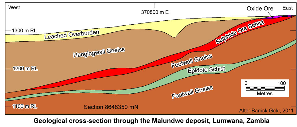
At Malundwe, the host tectono-stratigraphy comprises possible Neoproterozoic Upper Roan carbonates/calc-silicates, amphibolites, pelites and gabbros, separated from the overlying Palaeoproterozoic basement muscovite-quartz schist and quartzites by a D1 thrust. The quartzite is overlain by a sequence of speckled, mottled gneisses, as described above, and an epidote schist, that together constitute the Footwall Package. These are, in turn, overlain by the Ore Schist (which is a single lens to the north, split into two by an intervening gneiss towards the south). The Kanga area (previously referred to as the Malundwe South) is the southern, down plunge extension of the Malundwe deposit, separated by a gap of ~300 m (Moore et al., 2012).
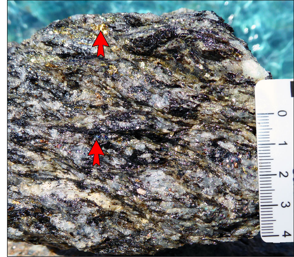
An example of high grade sulphide ore schist from the Malundwe pit, containing bornite (e.g., lower arrowhead) and chalcopyrite (e.g., upper arrowhead). Scale in cm. Image by Mike Porter 2014.
The overall strike length of mineralisation at Malundwe (including Kanga) is approximately 6 km north-south, and up to 1.5 km wide (east-west) as a single ore schist horizon that outcrops in the east, with an average thickness of 14 m, and a shallow dip to the west, plunging to the south. North-south ore shoots parallel a mineral elongation (stretching) lineation and the axes of low-amplitude, micro-to macro-scale folds in the schist. The mineralisation extends to a maximum depth of ~380 m below surface and is closed off in all directions. Malundwe is smaller than Chimiwungo, but with higher copper grades, containing discrete pods of high grade (and some areas of elevated background) uranium and gold mineralisation and occasional sporadic high cobalt (>0.1%; Bernau, 2007; Moore et al., 2012).
At Chimiwungo, the lower parts of the Footwall Package and underlying rocks are not exposed. The deposit is partitioned into three bodies by two steep WNW trending dip-slip fault zones. These mineralised zones are referred to, from south to north, as Chimiwungo South, Chimiwungo Main (including the Chimiwungo East shoot) and Chimiwungo North. Although each is described as a discrete structural entity, they represent the same dismembered mineralised package, collectively referred to as the Chimiwungo deposit. The deposit is composed of three "Mineralised Ore Schist" units, the Upper, Main and Lower Ore Schists, separated by two, near continuous, 'barren' gneiss bands, the Middle and Lower Gneiss, that range from quartz-feldspar-phlogopite gneiss to garnet amphibolite. In the thickest and highest grade section of the mineralisation, the barren Lower Gneiss unit is replaced by Mineralised Ore Schist, resulting in the merger of the Main and Lower Ore Schists (Bernau, 2007; Moore et al., 2012).
The Chimiwungo mineralisation extends for >4 km east-west and >5 km north-south, with a shallow dip to the south. It is sheeted, continuing beyond these limits, with grades and thicknesses decreasing away from the core of the deposit. This mineralisation is still open to the east and south, but pinches out to the west and is down-thrown by a series of late-stage, north-dipping, normal faults. The main body of the Chimiwungo deposit consists of multiple stacked mineralised zones, in aggregate varying from 40 to over 100 m in thickness. It is much larger than Malundwe, with lower copper grades, but has higher overall cobalt and contains a number of significant high-grade (>0.1%) cobalt zones plus some sporadic uranium mineralisation (Bernau, 2007; Moore et al., 2012).
The Chimiwungo South mineralisation extends for 2.8 km east-west and 1.5 km north-south, with a gentle southerly dip and plunge. The deepest drill intersections of the mineralisation to 2013 was ~680 m below surface. The northern limit of Chimiwungo South is defined by the Chimiwungo South Fault, which has down-dropped the mineralised package by ~300 m on the north side of the structure (Moore et al., 2012).
Chimiwungo Main is the down thrown continuation of Chimiwungo South on the north side of the Chimiwungo South Fault and is bound between this fault and the Chimiwungo North Fault. It consists of the same mineralised package and gneiss units that have a similar average dip and plunge to Chimiwungo South. The mineralisation covers an area of ~2.7 km north-south, by 4.2 km east-west, extending to ~495 m below surface on the southeastern limit of the Chimiwungo Main deposit, adjacent to the Chimiwungo South Fault zone. It also hosts the northern continuation of an ore shoot observed in the Chimiwungo South area which extends approximately 1.4 km north of the Chimiwungo South fault (Moore et al., 2012).
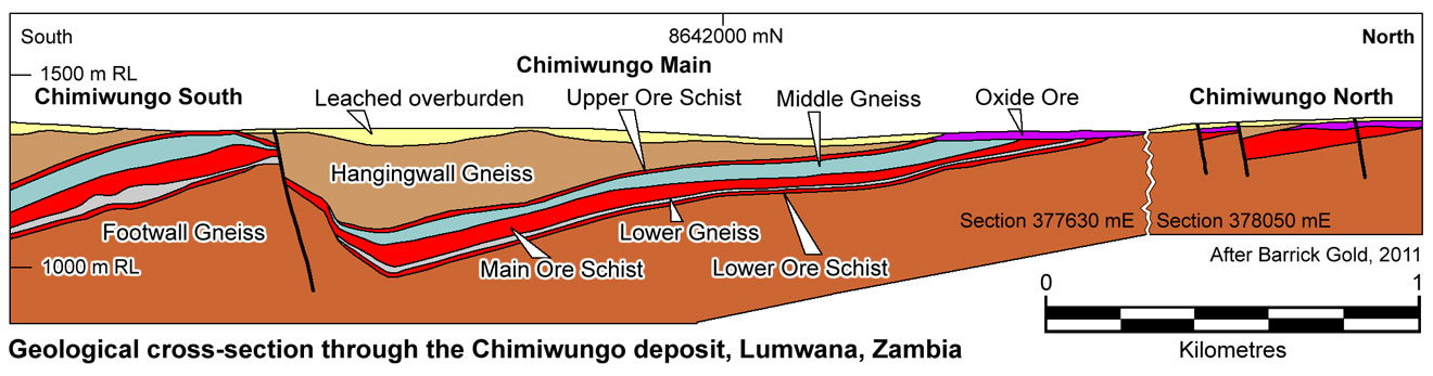
Chimiwungo North commences immediately north of the Chimiwungo North Fault, a steep dip-slip zone, similar in style to the Chimiwungo South Fault. This structure has down-dropped the mineralisation on the northern side of the fault by ~100 m. The mineralisation consists of one "Mineralised Ore Schist" unit, which appears to have resulted from the merging of the three "Mineralised Ore Schist" units seen in Chimiwungo Main. The mineralised zone dips and plunges gently to the south and (as drilled in 2012) extends over an area of 700 m north-south, by 450 m east-west, with a maximum depth of ~110 m. The eastern edge of the ore zone is an erosional boundary as defined by the current topographical surface. A gentle north-south trending antiform interpreted to the east of this erosional limit folds the mineralisation back below surface in the north eastern portion of Chimiwungo (Moore et al., 2012).
At both the Malundwe and Chimiwungo deposits, the Ore Package/"Mineralised Ore Schist" is limited by the overlying D1 Top Shear Zone, and is followed by the Hanging Wall basement gneisses (quartz-feldspar-phlogopite±muscovite±hematite-magnetite granite to pegmatite gneiss and quartz-phlogopite-muscovite-feldspar banded to augen gneiss). Copper sulphides within the Ore Schists are partitioned into micaceous shear zones characterised by significant Na and Ca depletion, and possibly by weak K±Mg addition. Muscovite-sericite overprints earlier biotite-phlogopite, and deformation accompanying its growth is the main control on the present distribution of copper sulphides (Bernau, 2007).
The sulphide mineralogy is zoned downwards from pyrite-chalcopyrite to chalcopyrite-carrollite (Chimiwungo only) to chalcopyrite-bornite. Bornite and chalcopyrite are replaced by lesser digenite, chalcocite and covellite. Minor uranium mineralisation occurs, locally crosscutting the Cu-Co, while quartz veins, commonly containing pyrite, chalcopyrite and bornite, cross-cut both the mineralisation and barren internal gneisses. Coarse, elongate, disseminations, aggregates and stringers of sulphide grains parallel the foliation and stretching lineaments. The sulphides are deformed by the S1 fabric, are overprinted by kyanite abnd occur as inclusions in kyanite porphyroblasts, implying the mineralisation predated, or accompanied, peak metamorphism (Bernau, 2007).
The uranium mineralisation at Lumwana is associated with the same muscovite-phlogopite-quartz-kyanite "Mineralised Ore Schist" lithology that hosts the copper mineralisation. At Malundwe, the fresh uranium typically lies within the "Mineralised Ore Schist" at the hanging wall and footwall contacts of the copper orebody, or in the immediate footwall to the copper mineralisation. In fresh rock the uranium is present as uraninite (UO2) and ranges from 10 µm to 5 cm aggregates, disseminated within the silicate gangue minerals (Moore et al., 2012).
The orebodies at Lumwana are tabular and elongated north-south, with thicknesses of tens of metres and strike lengths of kilometres, which dip and plunge parallel to the tectono-stratigraphy and to the foliation (S1) and stretching lineation (L1). Ore packages and individual ore-schist units pinch and swell to form lenses that are north-south oriented, parallel to the foliation and stretching lineation (Bernau, 2007).
According to the Equinox website, the Lumwana ore reserve and mineral resource, estimated by Golder Associates Pty. Ltd., in accordance with the JORC Code and CIM NI43-101 Standards, using a 0.2% copper cut-off and depleted for material mined to December 31, 2009 (production commenced in early 2009) was estimated as follows:
Measured + indicated resource - 342.5 Mt @ 0.74% Cu, 184 ppm Co, 0.02 g/t Au.
Inferred resource - 563.1 Mt @ 0.63% Cu, 46 ppm Co, 0.01 g/t Au.
Probable + proven reserve at Malundwe deposit - 105.7 Mt @ 0.86% Cu;
Probable + proven reserve at Chimiwungo deposit - 200.2 Mt @ 0.62% Cu;
Combined reserve - 305.9 Mt @ 0.70% Cu.
Uranium within the Malundwe and Chimiwungo copper deposits occurs as discrete uranium-enriched zones that are mined separately and stockpiled during the copper mining operation and as such, processing of the copper ore does not produce any uranium 'contamination' of resultant copper concentrate. The Lumwana uranium resource had been estimated at December 31, 2009, using a 0.01% uranium cut-off grade as:
Probable reserve - 3.3 Mt @ 0.123% U3O8;
Inferred Resource - 2.4 Mt @ 0.078% U3O8.
Published remaining Lumwana reserves and resources at December 31, 2012 (Barrick Gold Annual Report, March 2013), were:
Probable + proven reserve - 589.5 Mt @ 0.520% Cu;
Measured resource - 107.1 Mt @ 0.37% Cu;
Indicated resource - 822.9 Mt @ 0.51% Cu;
Inferred resource - 24.3 Mt @ 0.36% Cu.
This summary is taken from Bernau, R., 2007 - The geology and geochemistry of the Lumwana basement hosted copper-cobalt (uranium) deposits, NW Zambia; unpublished PhD thesis, University of Southampton, UK; Moore et al., 2012 - Technical Report on the Lumwana Mine, North Western Province, Republic of Zambia; NI 43-101 Technical Report by Roscoe Postle Associates Inc. for Barrick Gold Corporation, and the Barrick Gold Form 40-F Annual Report, dated 28/3/13, augmented by information from Hitzman et al., 2012.
The most recent source geological information used to prepare this decription was dated: 2012.
Record last updated: 16/11/2013
This description is a summary from published sources, the chief of which are listed below.
© Copyright Porter GeoConsultancy Pty Ltd. Unauthorised copying, reproduction, storage or dissemination prohibited.
|
|
|
|
|
Bernau, R., Roberts, S., Richards, M., Nisbet, B., Boyce, A. and Nowecki, J., 2012 - The geology and geochemistry of the Lumwana Cu (±Co±U) deposits, NW Zambia: in Mineralium Deposita v.48, pp.137-153.
|
Hitzman, M.W., Broughton, D., Selley, D., Woodhead, J., Wood, D. and Bull, S., 2012 - The Central African Copperbelt: Diverse Stratigraphic, Structural, and Temporal Settings in the Worlds Largest Sedimentary Copper District: in Hedenquist, J.W., Harris, M. and Camus, F., 2012 Geology and Genesis of Major Copper Deposits and Districts of the World - A tribute to Richard H Sillitoe Society of Economic Geologists Special Publication 16, pp. 487-514.
|
Moore C M, Danio J R and Altman K A, 2012 - Technical report on the Lumwana Mine, North Western Province, Republic of Zambia (selected excerpts): in NI 43-101 Technical Report prepared by Roscoe Postle Associates Inc. for Barrick Gold Corporation, www.sedar.com, 21p.
|
|
Porter GeoConsultancy Pty Ltd (PorterGeo) provides access to this database at no charge. It is largely based on scientific papers and reports in the public domain, and was current when the sources consulted were published. While PorterGeo endeavour to ensure the information was accurate at the time of compilation and subsequent updating, PorterGeo, its employees and servants: i). do not warrant, or make any representation regarding the use, or results of the use of the information contained herein as to its correctness, accuracy, currency, or otherwise; and ii). expressly disclaim all liability or responsibility to any person using the information or conclusions contained herein.
|
Top | Search Again | PGC Home | Terms & Conditions
|
|


