|
Oak Dam - Oak Dam West, Oak Dam East |
|
|
South Australia, SA, Australia |
| Main commodities:
Cu Au U
|
|
 |
|
 |
 |
Super Porphyry Cu and Au


|
IOCG Deposits - 70 papers

|
All papers now Open Access.
Available as Full Text for direct download or on request. |
|
 |
The Oak Dam iron oxide copper-gold-uranium mineralised system is located ~60 km SSE of Olympic Dam, 40 km NNW of Carrapateena, 20 km NE of Emmie Bluff and ~500 km NNW of Adelaide in northern South Australia. It comprises the low grade Oak Dam East and the deeper high grade Oak Dam West deposits which are 4 km apart (#Location: Oak Dam West - 30° 58' 31"S, 137° 12' 29"E).
Oak Dam West and East, along with Carrapateena, Olympic Dam, Prominent Hill, Moonta-Wallaroo and Hillside, and all of the other significant known IOCG mineralised systems of the Gawler craton are hosted within Palaeo- to Mesoproterozoic rocks and are distributed along the eastern edge of the currently preserved craton to define the Olympic IOCG Province.
See the Gawler Craton - Olympic IOCG Province and Carrapateena records for a summary of the broader tectonic, geologic and geophysical setting of the deposit.
Oak Dam East was discovered beneath 500 m of cover by Western Mining Corporation in December 1976, during their program of investigating intense coincident
gravity and magnetic anomalies following the discovery of Olympic Dam. Oak Dam West was discovered during subsequent infill and extension of the gravity coverage, in joint venture with BP Minerals. The two prospects were delineated between 1986 and 1988 in joint venture with PNC, a Japanese based uranium explorer. At the end of this program, 16 drill holes had penetrated pre-Pandurra Formation basement: 13 at Oak Dam East, two at Oak Dam West (AD4 and 7), and one drilled to basement between the two. The best intersections were in hole AD1 at Oak Dam East with up to 1.3% Cu and 1.35% U3O8 in a 200 x 200 and 60 m thick mineralised zone. In holes AD1 and AD6, the grade of gold was reported as <0.05 ppm Au. However, after a change in analytical practice, ironstone in all later holes was found to contain large intervals of 0.05 to 0.25 ppm Au (Davidson et al., 2007). A reappraisal of data led to the reassessment of the prospectivity of Oak Dam West and the drilling of holes to test the system peripheral to the barren hematite-quartz breccia intersected in drill hole AD4, as outlined below.
Oak Dam East
The Oak Dam East deposit underlies >500 m of cover, which comprises the Neoproterozoic Arcoona Quartzite and Tregolana Shale, and the post 1424 Ma Mesoproterozoic Pandurra Formation. Although absent now, a Gawler Range Volcanics (GRV) succession (~1591 Ma: Fanning et al., 1988) is interpreted to have unconformably overlain basement in the area prior to being removed by erosion that unroofed and stripped sections of the orebody and its enclosing rocks during the early Mesoproterozoic. By 1424 Ma, the deposit was overlain above a sharp unconformity by unaltered and unmineralised sandstones of the Pandurra Formation (Davidson et al., 2007). This interpretation is supported by the presence at Oak Dam West of intensely hematitised, disaggregated, feldspathic, porphyritic GRV-like volcanic rocks at the unconformity surface, overlain by hematitic conglomerate. Below this unconformity, the remnant Oak Dam East ironstone formed a distinct elongate basement high with an elevation of several hundred metres over a strike length of ~1.5 km, before the deposition of the Pandurra Formation.
The altered and mineralised schistose metagranitic basement below the unconformity has been interpreted to belong to the 1860 to 1845 Ma Donington Suite (Creaser, 1989). The basement is also characterised by rare 0.5 to 5 m thick dykes of undeformed coarse to pegmatitic alkali granite and minor, altered medium-grained diorite cut by specularite-quartz veins along the trace of a basement fault.
The Oak Dam East deposit comprises a large, sub-horizontal body of hematite and hematite matrix breccia ~200 m thick, which overlies an areally less extensive magnetite dominated core near the base of the system. Davidson et al. (2007) considered that the Oak Dam East breccia complex was formed at a shallow depth, following regional albite-calc silicate±magnetite alteration caused by hypersaline, 400 to 500°C fluids. Large-scale brecciation was an early feature, with progressive breccia-fill and replacement comprising the following paragenetic stages:
i). hematite and goethite (hematite stage I);
ii). magnetite-apatite-quartz±actinolite (magnetite stage). The hematite l and magnetite stages are evident in thin section, where a mesh of elongate hematite crystals are completely replaced and overgrown by magnetite which pseudomorphs hematite;
iii). hematite-goethite-quartz-chalcedony-pyrite-chlorite-monazite (hematite stage II). Tabular magnetite (which pseudomorphs hematite l), is in turn partially replaced and corroded by hematite stage II; and
iv). chalcopyrite-pitchblende-illite-hydromuscovite-florencite-carrolite (Cu- U-[Au] stage).
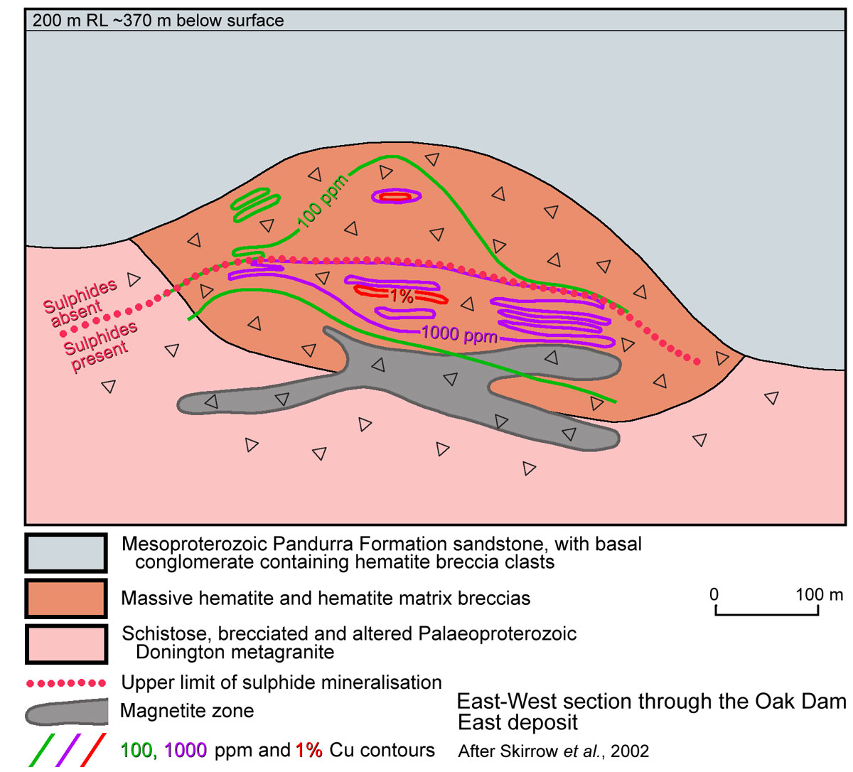 The deposit is divided into an upper sulphide-free, and lower sulphidic zone, the boundary being within the thick hematite rich upper layer. Davidson et al. (2007) outline observations and evidence that indicates the upper sulphide free to sulphidic zone interface reflects the limits of, chemical weathering below the implied Mesoproterozoic regolith suface prior to deposition of the Pandurra Formation. Alternatively, the same observations may suggest the interface represents a reaction front between a hot ascending and a descending cooler fluid during ore deposition. Below this interface, disseminated and vein chalcopyrite occurs in the upper parts of the sulphidic zone, while disseminated and vein pyrite occurs at depth.
In more detail, the alteration / mineralisation zoning is composed of:
i). an upper, sulphide-deficient, hematite-dominated breccia, which varies from 110 m thick in the centre to 80 m on the margins. The dominant primary feature in this zone is irregularly shaped relict zones of colloform banded hematite (typically 0.2 to 0.5 m diameter) in a matrix of replacive, massive, blue, steely hematite, most of which is assigned to hematite stage II. Clasts are entirely converted to hematite, with only zones of skeletal quartz fans that may be tens of cm across representing unconverted protolith. The upper 10 m of the ironstone below the unconformity is vughy and consists of massive to brecciated, weathered, brown to red and black hematite-goethite mixtures and brown caliche within the vugs;
ii). sulphide-bearing hematite-dominated breccia, which carries >0.1% Cu and is 60 to 80 m thick. This zone contains the main sub-horizontal, 10 to 70 m thick copper-uranium mineralised sheet, the top surface of which is generally found at the upper contact of the sulphidic zone. This mineralised sheet has an upper, variably developed low-grade transition to the underlying >1% Cu layer, which passes down in turn into a variable thickness 0.1 to 1% Cu zone. Mineralisation occurs as sulphides in the hematitic breccia matrix. A distinctive feature of the upper sections of the sulphide-bearing zone are domains of banded quartz and chalcedony with minor specular hematite, which developed during both the magnetite and hematite II stages;
iii). sulphide bearing, magnetite-dominated breccia, forms an irregular, 600 m long tongue that is 30 to 80 m thick, passing down into disseminated hematite (Davidson et al., 2007). Clasts within the breccia include red metagranite replaced by magnetite-apatite-amphibole (variably altered to chlorite), and colloform, banded magnetite. The breccia matrix is composed of semi-massive magnetite and infilling quartz. Martite surrounds fractures, veins and discrete vugs. Veins are filled by later hematite±pyrite±chalcopyrite. Some magnetite grains in the matrix are tabular and elongate, replacing hematite l (i.e., "mushketovite").
Breccia clasts in the basement vary from <1 mm to 5 m in diameter, but are typically ~20 cm across. Fragments of metagranite, schist, and minor felsic volcanic rocks become more
abundant ~100 m below the main high grade mineralised sheet, comprising 50 to 60 percent of the breccia. Many fragments have been partly replaced by hematite but have preserved a relict granoblastic to schistose texture, while in others the only preserved relicts are ribboned or equant metamorphic quartz.
Mineralisation is zoned vertically from pyrite at depth to shallower chalcopyrite. High-grade pitchblende occurs centrally within the chalcopyrite zone in the sulphide-bearing hematite-dominated breccia (e.g., 10 m of 0.46% Cu and 3.7 kg/t U3O8), straddling the boundary between a sericite-illite assemblage and underlying iron-magnesium-chlorite alteration. Chalcopyrite occurs intergrown with prismatic hematite, predominantly as crosscutting fine veinlets, patches, and infill within martite-lined interstices. Chalcopyrite commonly replaces pyrite, while very minor amounts of secondary Cu minerals (e.g., covellite) are associated with chalcopyrite dissolution. Carrolite (Cu(Co, Ni)2S4) and sphalerite occur along the contacts between chalcopyrite and colloform hematite. Within the main mineralised zone, uranium occurs as colloform pitchblende (UO2) in vuggy zones associated with chalcopyrite and hematite. This pitchblende is intimately intergrown with florencite (CeAl3(PO4)2(OH)6), monazite, and xenotime. The latter phases also contain very fine disseminated cubes of uraninite, <1 to 3µm in diameter. Fluorite is absent at Oak Dam East.
The Oak Dam East deposit is estimated to contain a resource of ~560 Mt @ 41 to 56% Fe, and 300 Mt @ 0.2% Cu.
Best intersections include: 63 m @ 0.3% Cu, 0.7 kg/t U3O8, including 5 m @ 7.1 kg/t U3O8.
This description is summarised and paraphrased from sections of Davidson et al. (2007).
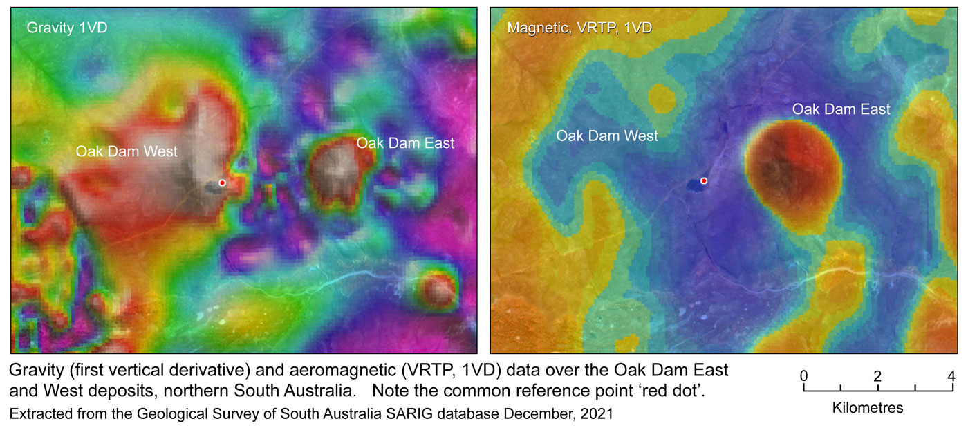
Oak Dam West
Davidson et al. (2007) speculated that Oak Dam East represents the remnant outer wing of a much larger, now eroded breccia complex with a core to the west. This core they suggest is partially represented by Oak Dam West, which has upper sections consisting of very thick, 'graded and resedimented' hematitic breccia, similar to some upper sections of the Olympic Dam Breccia Complex.
The initial drilling at Oak Dam West in 1967 by Western Mining Corporation Ltd was centred on a north-south elongated, ovoid, ~30 Mgal above background gravity anomaly. Altered upper basement in AD4, a drill hole near the centre of the gravity high, comprises barren, iron rich hematite breccias after granites and sedimentary rocks that carry <0.03% Cu. A further hole, AD7, ~700 m to the east of AD4 (see section below), intersected iron rich conglomerates and breccias at the expected base of post mineral cover in fault contact with moderately brecciated and sericite altered granite and is also barren (<0.01% Cu), whilst AD13 ~1 km NW of AD4 was still in post-mineral cover when terminated at 852 m. No further further drilling was undertaken for four decades.
A drilling program undertaken by BHP and reported in November 2018, indicated that drill hole AD4 had intersected the barren, downward tapering hematite-quartz core of a mineralised system that graded outwards and down, through hydrothermal hematite breccia and iron-altered granite breccia, into poorly, to un-altered Donington Suite granite. It also showed that drill hole AD7 was on the outer, low grade margin of this same system. Drilling continued through 2019, firming up the indications of the previous years work. The details of that continuing drill program are described below separately and illustrated by the plans and sections below as well as images of the key altered lithologies. A decision was taken in early 2021 to pass the project from 'exploration' to a 'detailed drill-out' phase.
In a progress release on the drill-out phase in August 2024, BHP announced an Inferred Mineral Resource at Oak Dam of
1.34 Gt @ 0.66% Cu, 0.33 g/t Au, at a 0.2% Cu cut-off, including
220 Mt @ 1.96% Cu 0.68 g/t Au in a bornite dominated domain at a 1% Cu cut-off.
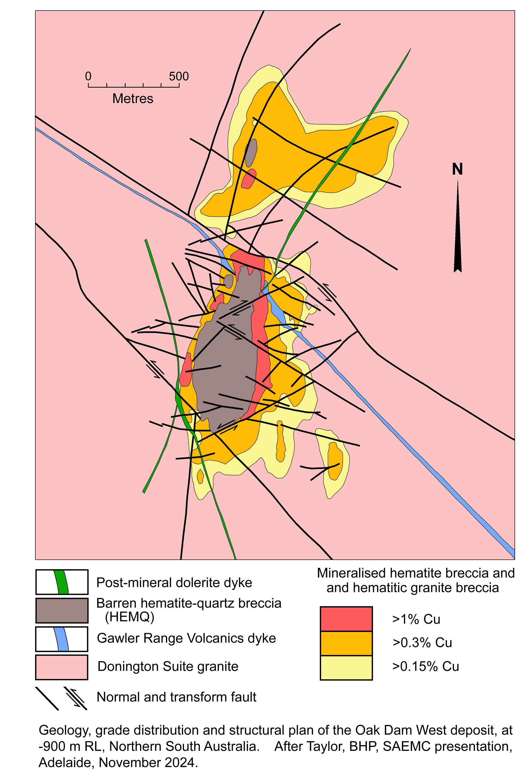
At the time of this update, no significant paper describing the deposit has been sighted. However, geological maps and sections have been shown in ASX Releases, in conference presentations and displays, while details of intersections are also available from those same sources, as included below, including drill hole intersections and images of the key lithologies.
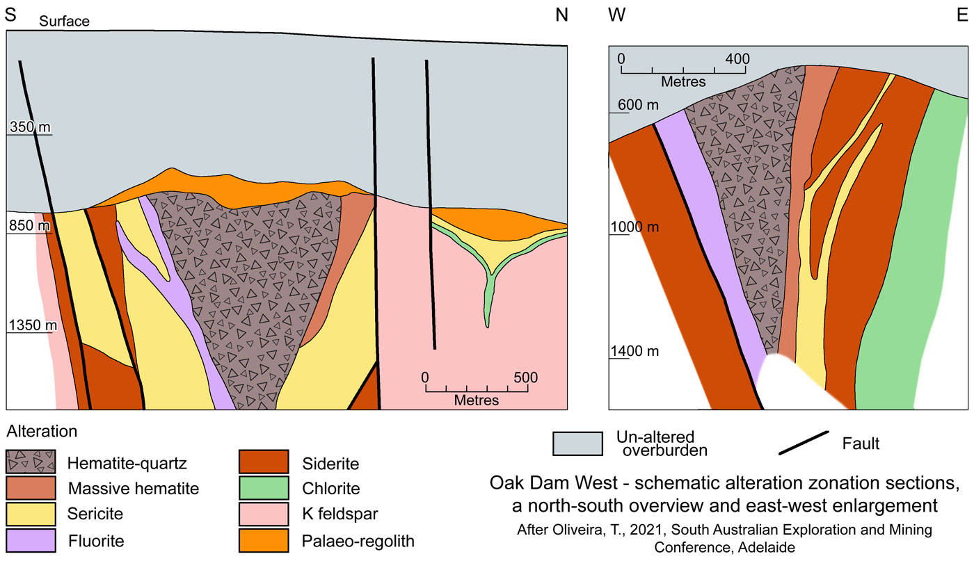
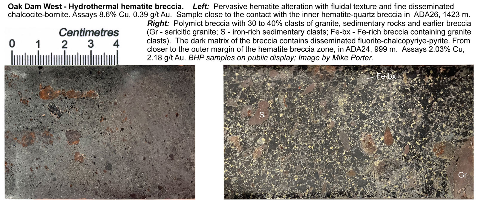
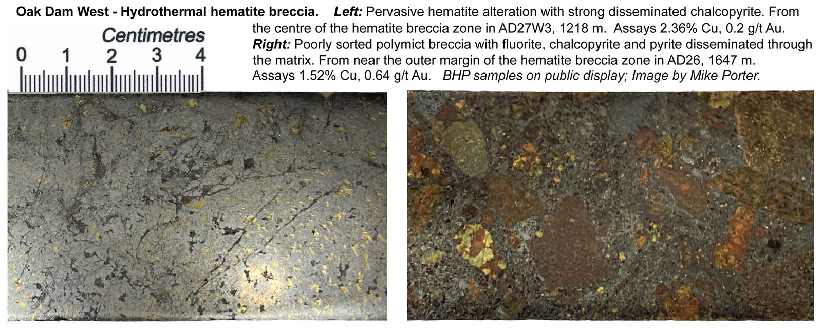
Work to date would appear to indicated the Oak Dam West system has an ~1 km x up to 500 m wide core of hematite-quartz breccia (HEMQ) representing the most intensely altered rocks of the system. This core is barren, with generally <100 ppm Cu, but does have zones of higher gold, presumably near the margins. It passes outward into pervasive hematite altered breccia containing both granitic and sedimentary clasts, and disseminated sulphides. This less altered rim to the barren HEMQ hosts a bornite dominated domain with the highest Cu grades of the system. This, in turn, passes outward into a less strongly altered periphery of hematite altered granite breccia, also with disseminated sulphides, and an outward diminishing Cu grade (see the images below). The generalised Cu-mineral gradation from the outer edge of the HEMQ core to the barren surrounding Donington Suite Granite, progresses from chalcocite → chalcocite-bornite → bornite → bornite-chalcopyrite → chalcopyrite → chalcopyite-pyrite → pyrite.
The topography of the unconformity at the base of the post-mineral cover sequence reveals the deposit sat below a palaeo-hill, presumably reflecting the more resistant HEMQ and hematite altered breccia in the core of the system (see section A-B below).
NOTE: The grade distribution plan above incorporates new information that became available in late 2024. It may be compared to the geological plan and sections below, which are based on information as known in 2021, and hence has some differences. These differences include better definition of faults. The two plans may be compared by the common outline of the barren hematite-quartz breccia (HEMQ) on both.
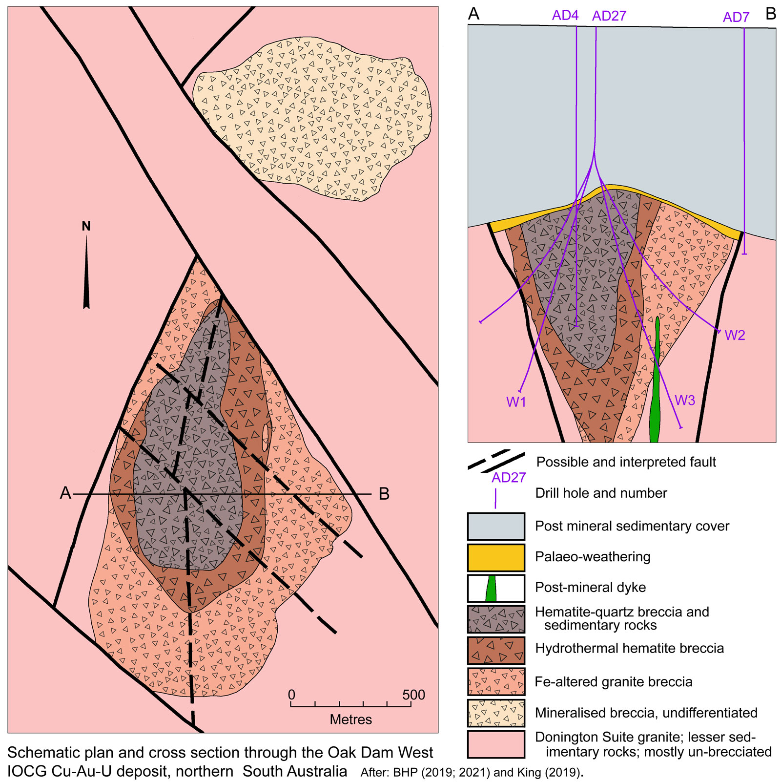
On 27 November, 2018, BHP released drilling results from Oak Dam West which included results from 4 diamond drill holes testing an area of ~400 to 500 m radius centred on the gravity anomaly described above. These drill holes intersected chalcocite, bornite and chalcopyrite mineralisation, which occur primarily as disseminations, and is associated with iron oxide rich breccias.
The mineralisation reported is overlain by between 700 and 950 m of consolidated post-mineral, sedimentary rocks of Meso- to Neoproterozoic and Lower Palaeozoic age.
The two 2018 drill holes on the southern 'slope' of the gravity high, returned the following intersections:
• AD22 - 124.5 m @ 0.52% Cu, 0.48 g/t Au. 0.085 kg/t U, 3.37 g/t Ag from a depth of 936 m; and
• AD24 - 406 m @ 0.66% Cu, 0.35 g/t Au, 0.266 kg/t U and 2.09 g/t Ag from a depth of 848 m.
The two intervals were ~220 m apart, and ~400 to 500 m south and SW of AD4 respectively, and the centre of the gravity high. The hosts rocks intersected in these holes were iron oxide and siderite altered, brecciated granites, with chalcopyrite dominant mineralisation.
Two drill holes on the northern 'slope' of the gravity high returned intersections of:
• AD23 - 425.7 m @ 3.04% Cu, 0.59 g/t Au. 0.346 kg/t U, 6.03 g/t Ag from a depth of 1063 m; and
• AD25 - 77 m @ 2.11% Cu, 0.54 g/t Au. 0.327 kg/t U, 2.94 g/t Ag from a depth of 1193 m.
These two interval are ~350 m apart and 300 to 400 m south and SW of AD4 respectively. AD23 included 180 m @ 6.07% Cu, 0.92 g/t Au, 0.401 kg/t U and 12.77 g/t Ag from a depth of 1070 m.
AD26 - drilled in 2019, crossing close to AD23, intersected 205 m @ 2.05% Cu, 3.8 g/t Au, including 44 m @ 5.77% Cu, 14g/t of gold, 1.2 g/t Ag and 643 ppm U.
Holes AD23 and AD25 passed downward from pervasively altered iron oxide rich breccias and fine grained sedimentary clastic rocks, which were generally barren of copper mineralisation, before cutting massive hematite breccias with high grade chalcocite-bornite mineralisation. Both holes end in moderate to weakly hematite altered, brecciated granites dominated by chalcopyrite mineralisation in AD23 and pyrite mineralisation in AD25.
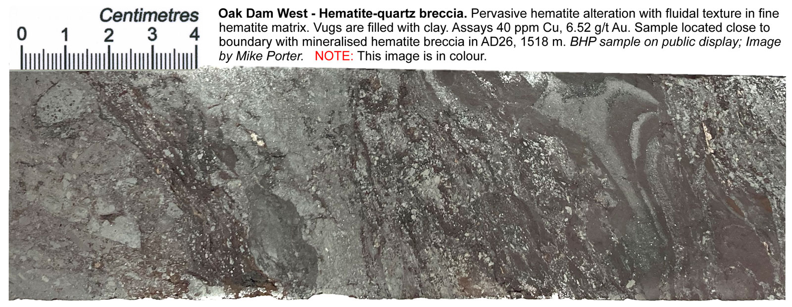
The 2019 BHP release confirmed the geometry outlined above, whilst a presentation at the South Australian Exploration and Mining Conference in Adelaide in 2021 by T. Oliveira of BHP Exploration refined the plan image to that outlined above. This geometry comprises an upward expanding cone shaped core of 'barren' hematite-quartz breccia and sedimentary units with its apex at a depth of 1220 m below sea level, which has a maximum east-west width of ~500 m at the unconformity with Neoproterozoic overburen at a depth of 500 to 700 m below sea level. In plan, this barren core is interpreted to have a northward tapering tear-shape that is ~1250 m long. This depth variation represents a Neoproterozoic palaeohill near the centre of the mineralised system, the peak of which is ~650 m below the surface. The 'barren' hematite-quartz breccia core, carries very low Cu grades, but does locally contain significant gold, as shown in the core image below. It is surrounded laterally and downward by a broader and deeper cone of hydrothermal hematite breccia that extends for a further 50 to 180 m outward from the core, but thins to near zero width on the western extremity of the system. This then passes outward into Fe-altered granite breccia than forms a sheath around the hydrothermal hematite breccia, that is as much as 400 m wide in the south, but again thinning toward the northern tip. Steep, inward dipping, faults are interpreted to truncate the deposit to the NW, NE and SW. The mineralisation is hosted by both the hematite breccia and the Fe-altered granite breccia. The Fe-altered granite breccia grades outward into unbrecciated granite (King, 2019). Oliveira (2021) indicated another area of mineralised breccia to the north, separated from the main deposit by a 500 m wide fault bound corridor of strongly K feldspar altered granite.
There is an abrupt increase in grade at the contact between the barren core and the mineralised hydrothermal hematite breccia, before gradually decreasing outwards through the latter into the Fe-altered granite breccia (King, 2019).
The granite country rock is part of the 1860 to 1845 Ma Donington Suite which has been weakly to moderately deformed. The Fe-altered granite breccia has undergone multiphase brecciation, with sericite altered granite clasts overprinted by hematite alteration, which is most intense in the matrix. Mineralisation is mainly chalcopyrite-pyrite which is disseminated in both the matrix and clasts. The hydrothermal hematite breccia has undergone pervasine iron oxide alteration, with hematite overprinting magnetite that only remains as relicts. It has also undergone multiphase brecciation, and contains chalcocite-bornite mineralisation as disseminations grading to massive accumulations. The barren hematite-quartz breccia and sedimentary units have undergone extreme hematite-quartz alteration with multiple textures, that range from vuggy to banded to massive. Pervasive red hematite alteration has been weathered below the Neoproterozoic unconformity with local barite and calcite veining. It is barren of copper, but may contain some gold mineralisation (King, 2019).
The drill holes reported in 2019 were commenced above the centre of the mineralised system, with wedged daughter holes to the east and west cutting the barren core and passing outward to end in unaltered granite. The one exception was AD 26 which was collared in the east, and wedged to give two intersections, both of which passed through the eastern mineralised annulus, the barren core and western annulus to barren granite. Drilling results were:
• AD26 - 6571236 mN Deeper intersection
Fe altered granite breccia - east 141 m @ 0.40% Cu, 0.15 g/t Au, 0.200 kg/t U, 1.0 g/t Ag from a depth of from 1047 m
Hematite breccia - east - 205 m @ 2.04% Cu, 0.43 g/t Au, 0.441 kg/t U, 3.8 g/t Ag from a depth of from 1247 m
Hematite breccia - west - 4 m @ 3.33% Cu, 0.34 g/t Au, 0.102 kg/t U, 7.6 g/t Ag from a depth of from 1593 m
Hematite breccia - west - 90 m @ 1.63% Cu, 0.56 g/t Au, 0.209 kg/t U, 2.5 g/t Ag from a depth of from 1605 m
Outer western hematite breccia faulted out
• AD26 - 6571236 mN - Shallower intersection
Hematite breccia - east - 70 m @ 1.26% Cu, 0.05 g/t Au, 0.222 kg/t U, 2.3 g/t Ag from a depth of from 1005 m
Hematite breccia - east - 188 m @ 1.55% Cu, 0.25 g/t Au, 0.444 kg/t U, 3.0 g/t Ag from a depth of from 1289 m
Hematite breccia - east - 41 m @ 0.95% Cu, 0.50 g/t Au, 0.105 kg/t U, 2.9 g/t Ag from a depth of from 1572 m
Western hematite breccia faulted out
• AD27 - 6571048 mN - first, shallower Western Wedge, to fault
Hematite breccia - west - 97 m @ 1.51% Cu, 1.04 g/t Au, 0.270 kg/t U, 4.0 g/t Ag from a depth of from 1100 m
• AD27 - 6571048 mN - second, deeper Western Wedge,
Hematite breccia - west - 105 m @ 1.59% Cu, 0.85 g/t Au, 0.234 kg/t U, 5.3 g/t Ag from a depth of from 1250 m
Hematite breccia - west - 22 m @ 1.27% Cu, 0.69 g/t Au. 0.173 kg/t U, 4.6 g/t Ag from a depth of from 1362 m
Hematite breccia - west - 8 m @ 1.26% Cu, 0.43 g/t Au, 0.139 kg/t U, 4.9 g/t Ag from a depth of from 1402 m
• AD27 - 6571048 mN - third, shallower Eastern Wedge
Hematite breccia - east - 422 m @ 0.80% Cu, 0.23 g/t Au, 0.233 kg/t U, 2.5 g/t Ag from a depth of from 952 m
including - 22 m @ 3.36% Cu, 0.58 g/t Au. 0.488 kg/t U, 9.0 g/t Ag from a depth of from 952 m
• AD27 - 6571048 mN - fourth, deeper Eastern Wedge
Hematite breccia - east - 9 m @ 1.57% Cu, 1.42 g/t Au. 0.183 kg/t U, 8.7 g/t Ag from a depth of from 1052 m
Hematite breccia - east - 335 m @ 1.38% Cu, 1.29 g/t Au. 0.160 kg/t U, 8.2 g/t Ag from a depth of from 1071 m
including - 42 m @ 3.06% Cu, 0.92 g/t Au. 0.266 kg/t U, 13.6 g/t Ag from a depth of from 1071 m
• AD28 - 6570816 mN - first shallower Western Wedge
Hematite breccia, patchy - west - 84 m @ 0.63% Cu, 0.40 g/t Au. 0.140 kg/t U, 2.7 g/t Ag from a depth of from 1150 m
• AD28 - 6570816 mN - second deeper Western Wedge
Hematite breccia, patchy - west - 89 m @ 0.82% Cu, 0.48 g/t Au. 0.056 kg/t U, 3.2 g/t Ag from a depth of from 1185 m
Hematite breccia, patchy - west - 139 m @ 0.49% Cu, 0.37 g/t Au. 0.034 kg/t U, 3.2 g/t Ag from a depth of from 1298 m
• AD28 - 6570816 mN - third shallower Eastern Wedge
Hematite breccia, patchy - east - 300 m @ 0.83% Cu, 0.14 g/t Au. 0.686 kg/t U, 6.9 g/t Ag from a depth of from 1132 m
Fe altered granite breccia - east - 197 m @ 0.83% Cu, 0.18 g/t Au. 0.238 kg/t U, 1.4 g/t Ag from a depth of from 1132 m
Fe altered granite breccia - east - 91 m @ 0.54% Cu, 0.34 g/t Au. 0.091 kg/t U, 2.3 g/t Ag from a depth of from 1356 m
• AD28 - 6570816 mN - fourth deeper Eastern Wedge
Hematite breccia - east - 88 m @ 1.27% Cu, 0.21 g/t Au. 0.125 kg/t U, 4.1 g/t Ag from a depth of from 930 m
Fe altered granite breccia - east - 108 m @ 0.61% Cu, 0.20 g/t Au. 0.281 kg/t U, 0.9 g/t Ag from a depth of from 1061 m
Fe altered granite breccia - east - 492 m @ 0.40% Cu, 0.22 g/t Au. 0.111 kg/t U,2.1 g/t Ag from a depth of from 1188 m.
The intersections and geological interpretations above are based on a 17 786 m deep drilling program undertaken between April 2018 and June 2019. A decision was taken in early 2021 to pass the project from 'exploration' to a 'detailed drill-out' phase.
Images of representative, polished, lacquered half core samples displayed by BHP Exploration at the South Australian Exploration and Mining Conference in Adelaide on 26 November, 2021 are shown below.
The most recent source geological information used to prepare this decription was dated: 2024.
Record last updated: 1/1/2025
This description is a summary from published sources, the chief of which are listed below.
© Copyright Porter GeoConsultancy Pty Ltd. Unauthorised copying, reproduction, storage or dissemination prohibited.
Oak Dam West
|
|
|
|
|
BHP Group 2018 - BHP copper exploration program update: in BHP Group Press Release, 27 November, 2018 7p.
|
Davidson G J, Paterson H, Meffre S and Berry R F, 2007 - Characteristics and Origin of the Oak Dam East Breccia-Hosted, Iron Oxide Cu-U-(Au) Deposit: Olympic Dam Region, Gawler Craton, South Australia: in Econ. Geol. v102 pp 1471-1498
|
Katona, L., 2020 - Geophysical signatures of IOCG prospects in the Olympic Cu-Au Province: in Mesa Journal v.92, pp. 26-37.
|
King, J., 2019 - Oak Dam - An early exploration opportunity: in South Australian Exploration and Mining Conference, Adelaide Convention Centre, Friday 27 November 2020, SAEMC Online Proceedings Archive, http://saemc.com.au/archive/2019/2019_03_king.pdf, 13p.
|
|
Porter GeoConsultancy Pty Ltd (PorterGeo) provides access to this database at no charge. It is largely based on scientific papers and reports in the public domain, and was current when the sources consulted were published. While PorterGeo endeavour to ensure the information was accurate at the time of compilation and subsequent updating, PorterGeo, its employees and servants: i). do not warrant, or make any representation regarding the use, or results of the use of the information contained herein as to its correctness, accuracy, currency, or otherwise; and ii). expressly disclaim all liability or responsibility to any person using the information or conclusions contained herein.
|
Top | Search Again | PGC Home | Terms & Conditions
|
|