|
Mutanda, Deziwa, Tilwezembe, Kansuki, Kisanfu and Kalumbwe-Myunga |
|
|
Dem. Rep. Congo |
| Main commodities:
Cu Co
|
|
 |
|
|
 |
Super Porphyry Cu and Au


|
IOCG Deposits - 70 papers
|
All papers now Open Access.
Available as Full Text for direct download or on request. |
|
|
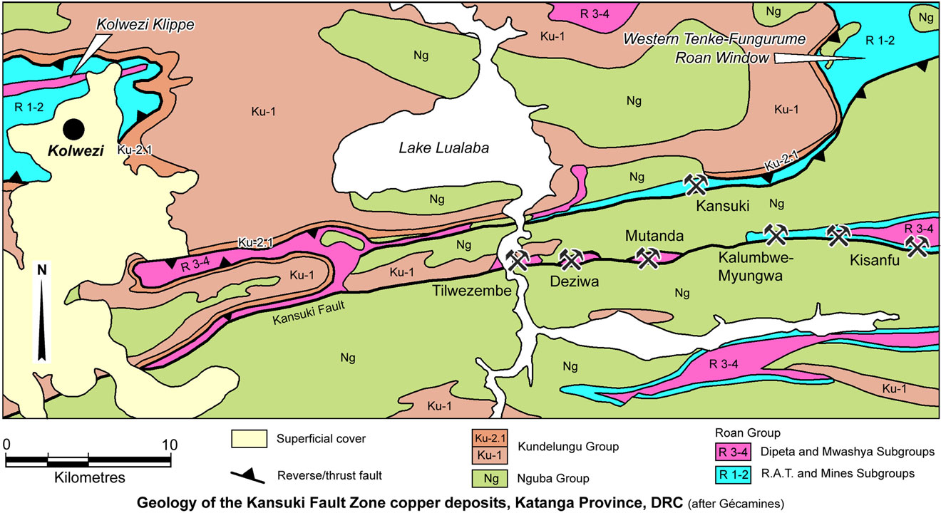
The Mutanda, Deziwa, Tilwezembe, Kalumbwe-Myunga, Kisanfu and Kansuki sediment hosted copper-cobalt deposits define a generally east-west trending, 30 km long mineralised corridor in the southern Katanga Province of the Democratic Republic of Congo (DRC). They are distributed along the major Kansuki Fault, and a parallel structure, 3 to 5 km to its north, located 39, 32, 25, 50, 54 and 41 km to the ESE of Kolwezi respectively, and ~210 km WNW of Lubumbashi. They are in the northwestern section of the ~350 km long Congolese Copperbelt, part of the larger Central African Copperbelt that extends south into Zambia.
The Mutanda Concession was first explored by Gecamines in the 1980s, mapping the stratigraphy and establishing that mineralisation was hosted by rocks then included within the Lower Mwashya Subgroup, more recently reassigned to the upper Dipeta Subgroup (Cailteux et al., 2007; Hitzman et al., 2012; Schuh et al., 2012), both of which are members of the Neoproterozoic Roan Group. Subsequent drilling, soil geochemistry and geophysics by Gecamines, which commenced in 2004, and from 2005 on behalf of Mutanda Mining SPRL, has defined the near surface resources at Mutanda. Artisanal surface and underground mining took place from 2004 to 2005, when it was declared unsafe and closed. Mining by Mutanda Mining SPRL was commenced at Mutanda in 2010. Mutanda Mining SPRL has since been merged with Kansuki SPRL, to include the Kansuki resource on the neighbouring concession to the north. The enlarged operation is majority controlled by Glencore Xstrata from 2013.
Gecamines undertook mining at Tilwezembe intermittently, from 1999 to 2008, and the operation has subsequently been closed, although working by artisanal miners has continued. The property has since become part of the Glencore Xstrata controlled Katanga Mining Limited Kolwezi operation. The Deziwa deposit, previously in a concession held by Gecamines, is located between Tilwezembe and Mutanda, while Kalumbwe-Myungwa, Kisanfu (CuCo Resources) and Kisanfu (Freeport) are located progressively eastward from Mutanda. Most of these deposits have only previously been worked by artisanal miners.
This group of deposits has total resources (including inferred) in excess of >1 Gt @ 1.4 to 2.6% Cu.
Regional Setting
For details of the regional setting of this district, the Central African/Congolese Copper Belt and the Lufilian Arc, see the Central African Copperbelt - Congolese/Katangan Copperbelt record.
Geology
Most of these deposits are distributed along an ENE-WSW to east-west trending anticlinal lineament, the core of which is dislocated by the parallel Kansuki Fault, a major fault zone which stretches from south west of Kolwezi in the west, to beyond the Kisanfu deposits in the east, over a distance of >75 km. The Kansuki Fault zone is the trace of both a D1 north vergent thrust, and a D2 sinistral strike-slip fault (Kapunza and Cailteux, 1999). The anticlinal structure is northward verging to the west of Tilwezembe, becoming upright to the east of Mutanda, through Kalumbwe-Myungwa and Kisanfu, and well to the ESE becomes south vergent. This corresponds to a change in its trend from WSW to east-west to ESE.
The Kansuki deposits, and a series of extensive artisanal workings, are located along a second, sub-parallel, but eastward diverging fault zone, 3 to 5 km to the north, which extends from south of the Kolwezi Klippe, to the southwestern margin of the Tenke-Fungurume Roan Window, 50 km to the east. This structure forms the axis of an elongate, narrow (<500 m to 2 km wide), WSW-ENE trending Roan Group megabreccia, the western extremity of which is ~10 km SE of Kolwezi.
The western ~10 km of this Roan megabreccia is ~2 km wide, and structurally overlies the younger Kundelungu Ku-2.1 unit on both its northern and southern margins, forming a tight synform, a similar relationship to that at the base of the broader, and more gently folded synformal Kolwezi Klippe, ~8 km to the NW (see the separate Kolwezi record).
East of this western thicker section, the synformal Roan Group sliver associated with the northern fault, thins drastically, but continues along the eastern extension of the structure, bordered to the north by unit Ku-2.1 (at least in part), for >30 km, to merge into the broader Tenke-Fungurume Roan Window megabreccia in the east. This fault zone marks the southern margin of the Kalongwe-Fungurume tectonic lineament.
At the eastern end of the western thicker section detailed above, a thick north-south branch connects the main northern Roan Group megabreccia synform, via a structural saddle in the intervening antiform, to a narrow south dipping strip of similar rocks that follows the northern margin of the Kansuki fault westward, still structurally overlying unit Ku-2.1. To the east of this linking 'saddle', the Kansuki fault juxtaposes Nguba and Kundelungu groups rocks without any intervening Roan Group lithologies, although the latter does reappear 8 km to the east, where it hosts the Tilwezembe deposit, truncated by the Kansuki fault to the south, and overlain by Nguba and Kundelungu groups rocks to the north.
Eastward from Tilwezembe, there is a gap of several kilometres before an ~2 km long sliver of Roan Group rocks reappears, following the trace of the Kansuki Fault, where it hosts the Deziwa deposit. Another gap then ensues to the east, before a further narrow, fault bounded lens of Roan Group rocks are exposed over another interval of ~2 km, hosting the Mutanda deposits. A larger, almond-shaped antiformal structure opens up along the trend of the Kansuki Fault ~5 km to the east of Mutanda, with a length of ~15 km and maximum width of ~2.5 km, which hosts Kalumbwe-Myungwa near its western extremity, and then the Kisanfu deposits.
Over the interval from west of Tilwezembe to east of Kisanfu, the Nguba Group sequence to the south of the Kansuki fault dips at 30 to 60°S and youngs in the same direction, generally striking parallel to the fault. The sequence to the north has variable dips and strikes relative to the fault, generally dipping into, and younging towards the structure to the west, and away to the east, i.e., the fault that emplaced the southern limb has truncated and partially to totally removed the northern limb.
In the Kolwezi Klippe and the Tenke-Fungurume Roan Window, extensive areas (tens to hundreds of km2) of deformed Roan Group rocks are underlain by relatively flat, gently folded décollements, 'concordantly' overlying younger Kundelungu Group rocks, frequently unit Ku-2.1. In the Tilwezembe-Mutanda-Kisanfu-Kansuki district, Roan Group rocks are also found 'concordantly' emplaced over unit Ku-2.1, but have been more intensely folded and truncated by faulting into narrow structural corridors.
The Kansuki deposits are hosted by Roan Group rocks immediately adjacent to the northern fault, ~5.5 km NNE of Mutanda.
The host Roan Group rocks associated with these structures apparently belong to the Dipeta (R-3) and Mwashya (R-4) subgroups to the west of both Kalumbwe-Myungwa and Kansuki, but also include the R.A.T. (R-1) and Mines (R-2) subgroups to the east.
The Kolwezi Klippe and Tenke-Fungurume Roan Window contain écailles (French for 'fish-scales', a local structural term for tabular tectonic megabreccia blocks) of Mines and Dipeta subgroups rocks within a matrix of fine rock flour to cm sized and larger fragments of R.A.T., Mines and Dipeta subgroups rocks.
The mineralisation within these larger klippen is almost exclusively hosted by the lower members of the Mines Subgroup (R-2). However, at Tilwezembe, Deziwa and Mutanda at least, the main host to ore is the uppermost unit of the Kansuki Formation at the top of the younger Dipeta Subgroup (R-3). In addition, the ore is hosted by generally shallow-dipping, structurally inverted imbrications of the Kansuki Formation and basal Nguba Group, rather than by écailles within a megabreccia.
This description is based on Gecamines Departement Geologique 1:200 000 mapping reproduced in Dixon et al. (2007), and diagrams in van der Schyff (2012) and Kapunza and Cailteux (1999).
Tilwezembe (#Location: 10° 47' 59"S, 25° 41' 31"E)
Geology - Tilwezembe is the westernmost of this string of deposits. The complex faulted Tilwezembe anticline is located on the northern margin of the Kansuki Fault, where the mineralised host unit has a known strike length of ~1 km and dips between 40 and 50°S, with a thickness that generally varies between 20 and 50 m. This layer extends to a depth of >250 m below the surface. Mineralisation is hosted by R-3.4.3, the uppermost unit of the Kansuki Formation (R-3.4), which is the highest formation of the Dipeta Subgroup, previously included within the Lower Mwashya Subgroup (Dixon et al., 2007).
Mineralisation is hosted by vuggy to massive and strongly brecciated, altered and stratified siliceous dolostones and dolomitic shales, beneath a prominent hanging wall marker hematitic ironstone and ferruginous dolostone, with a few interbeds of light yellow talcose dolostone (Dixon et al., 2007).
Mineralisation is also hosted by parts of the younger, brecciated, Nguba Group that occurs in the structural footwall of the Dipeta Subgroup, where it is mainly composed of argillites, sandstones and shales (Dixon et al., 2007).
Structurally, the Roan Group rocks constitute the core of a southward-dipping listric thrust zone overlying the younger Nguba Group. The latter comprise various massive, bedded and brecciated argillites and tillites, which are in turn, thrust over younger maroon Kundelungu Group argillites (Dixon et al., 2007). Mwashya Subgroup rocks are not recognised.
Mineralisation - Mineralisation generally occurs as i). infilling of vugs and strongly correlates with silicification of dolomite, and ii). infilling of fissures and open fractures associated with the brecciation in all lithologies (Dixon et al., 2007; van der Schyff, 2012).
Thin carbonaceous shale at the base of the mineralised Kansuki Formation always carries very abundant bedded and breccia-hosted carrollite and chalcocite. While the bulk of the Cu-Co mineralisation is hosted in these rocks, significant though irregular amounts are pervasively developed within the fractured structurally underlying Nguba Group rocks (Dixon et al., 2007).
Mineralisation in the oxide zone extends to 60 to 100 m below the surface, and typically consists predominantly of malachite, with traces of libethenite (in the footwall) and the cobalt mineral heterogenite, which is intimately associated with manganese oxides (psilomelane and manganite). Towards the base of the oxide zone, native copper is locally common along with sphaerocobaltite (CoCO3). The bulk of the sulphide assemblage comprises carrollite, chalcocite and some bornite, with traces of chalcopyrite. Within the underlying basal Nguba Group Grand Conglomérat, strongly fractured tillite and argillite, which are normally variably oxidised, contain malachite, minor native copper and chrysocolla (Dixon et al., 2007).
Published remaining JORC compliant mineral resources at December 31, 2011 (van der Schyff, March, 2012, Technical Report prepared for Katanga Mining Ltd) at a 0.5% Cu cut-off, and quoting total Cu and total Co, were:
Measured + indicated resources - 9.50 Mt @ 1.89% Cu, 0.60% Co;
Inferred resources - 13.8 Mt @ 1.75% Cu, 0.60% Co.
Production figures for the period from 1999 to 2008 have not been encountered,
although in the final year, 2008, the mine produced 0.610 Mt @ 1.39% Cu, 1.17% Co.
Deziwa (#Location: 10° 47' 21"S, 25° 45' 47"E)
The Deziwa deposit is located between Tilwezembe and Mutanda in an ~2 km long sliver of Roan Group rocks, along the trace of the Kansuki Fault. No additional geological information has been encountered, although the deposit is assumed to be similar to Tilwezembe and Mutanda.
Published JORC compliant mineral resources at March, 2009 (report dated March 2009, prepared by Golder Associates) at a 0.5% Cu cut-off were:
Measured resource - 75.145 Mt @ 1.78% Cu Total, 1.62% Cu Acid sol., 0.17% Co Total;
Indicated resource - 240.883 Mt @ 1.33% Cu Total, 1.17% Cu Acid sol., 0.11% Co Total;
Inferred resource - 3.341 Mt @ 1.80% Cu Total, 1.48% Cu Acid sol., 0.17% Co Total;
TOTAL resources - 319.369 Mt @ 1.44% Cu Total, 1.28% Cu Acid sol., 0.12% Co Total.
Mutanda (#Location: 10° 47' 07"S, 25° 48' 37"E)
The Mutanda deposit is located ~8 and ~3 km to the east of Tilwezembe and Deziwa respectively within a small thrust slice bounded sliver of Roan Group sedimentary rocks developed along, or within the steeper and later Kansuki fault zone.
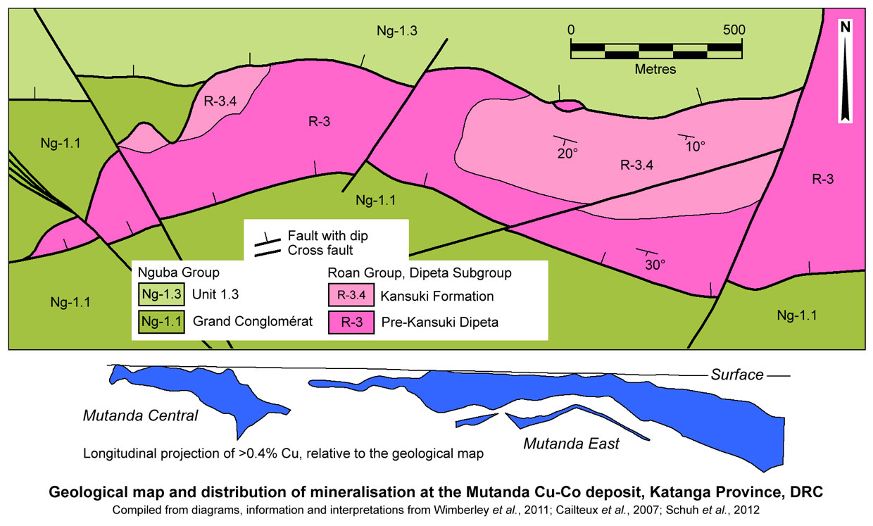
Geology - The stratigraphic units at Mutanda include the Dipeta R-3 of the Roan Group, and the Ng-1.1 (Grand Conglomérat) and Ng-1.3 (Kakontwe Formation) of the Nguba Group. Within the deposit, the stratigraphy is overturned and contacts between the three main units are tectonic, and in places occupied by breccias. Exposure over the deposit area is generally poor, particularly of the Roan Group rocks, with the topographic highs occupied by clastic sediments of the Nguba Ng-1.1. The bulk of the deposit lies under a cover of red soil (terre rouge) and laterite (sollaterite), locally containing nodules of heterogenite (Wimberley et al., 2011).
The oldest, and structurally highest rocks in the deposit area belong to the Dipeta Subgroup (R3) and consist of argillite, which is highly weathered with a distinctive talcose feel on broken and jointed surfaces. The exposures are frequently massive and can be red to purple, ochreous yellow or grey, and more rarely white. In places this rock has a brecciated appearance with a black manganese oxide or red/yellow (iron) staining on the multitude of random joints within the body of the rock. The other main lithology within the lower and middle Dipeta Subgroup is a banded rock, possible a fine-grained pyroclastic. It is green in fresh exposures, and pink when highly weathered, with multihued alteration spots, generally spherical and of variable size, up to 30 mm across. Meso-scale banding is diffuse and ranges from darker green to a cream/green in colour.
This part of the Dipeta Subgroup is typically weathered to greater depths than the other units and no fresh rock has been intersected in drilling (Wimberley et al., 2011).
These Dipeta Subgroup rocks are in structural contact with the Nguba Ng-1.1, Nguba Ng-1.3 (at depth) units and the mineralised Kansuki Formation at the top of the Dipeta Subgroup. These contacts are typically the locus of brecciation, which has been infiltrated and cemented by silica and iron/magnesium oxides. Where in contact with the structurally underlying Kansuki Formation host unit, the breccias locally contain heterogenite (Wimberley et al., 2011).
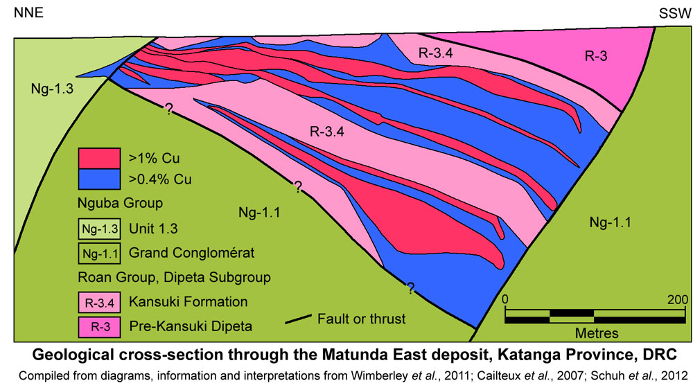
In fresh drill core, the host upper Kansuki Formation (R-3.4), which structurally underlies the older R-3 described above, is very different in appearance. It largely comprises recrystallised stromatolitic dolostone containing veinlets and disseminations of chalcocite and carrollite, and more rarely bornite. The stratigraphically lower parts of this dolostone include intercalated, finely bedded, dolomitic argillites which contain fine disseminations and veinlets of copper and cobalt sulphides along bedding planes, with coarser disseminations of the same minerals (particularly euhedral carrollite) dispersed throughout. In the upper part of the unit, there are two distinctive and consistent marker beds: i). a persistent specular haematite layer, often in close proximity to a thin jaspilite layer and ii). a more diffuse band of oolitic dolomite. Above the dolomite, there is an intermittently preserved, but locally highly mineralised, black shale layer which has only been intersected in a limited number of drill holes. The stratigraphically highest, and structurally lowest part of the unit is a chaotic breccia, interpreted to be the collapsed remnants of an original evaporite removed by hydrothermal fluids (Wimberley et al., 2011).
 Near surface, the host R-3.4 is strongly weathered and contains significant copper and cobalt oxide mineralisation, predominantly malachite and heterogenite, which occur together but in very different proportions, with lenticular zones containing much richer accumulations of one or other of these minerals. The intense surface weathering includes silicification, friable iron-rich oxide material (with some magnesium oxides) and zones of malachite and heterogenite. One part of the western pit of the central Zone appears to represent a recent collapse breccia filled with iron-oxide altered rock (Wimberley et al., 2011).
At Mutanda, the underlying, younger Nguba Ng-1.1 Grand Conglomérat is a greenish diamictite when fresh, weathering to pink, pale yellow or grey-white near surface. The clasts within this unit, which are of variable composition and size, including crystalline basement rocks, tend to be widely dispersed and in some areas are absent. This unit is restricted to the Central, Southern and Western Zones in the northern part of the deposit area, and forms the footwall to the main mineralised unit in the western part of the Central Zones but is terminated against a cross fault to the east (Wimberley et al., 2011).
Where the Grand Conglomérat is in contact with the main R-3.4 host, it is typically mineralised, and near surface, to depths of up to 60 m, contains veinlets of malachite along joint planes, with very little accompanying cobalt. Other rocks encountered to the south of the deposit include a succession of repeated fining-upward sedimentary beds with a thin, intermittent, matrix-supported conglomerate below more continuous beds of grit, sandstone, siltstone and shale, and a very finely banded argillite which appears to be of glacial origin, and hence tentatively assigned to Ng-1.1 (Wimberley et al., 2011).
The Ng-1.2, normally composed of banded shales and dolostone beds is absent at Mutanda, and the Nguba Group Ng-1.3 unit is normally in contact with the Grand Conglomérat and the Roan lithologies. Nguba Group unit Ng-1.3 is a very distinctive purple argillaceous siltstone, which forms the structurally lowest unit below the mineralisation at Mutanda (Wimberley et al., 2011).
Structure - The dominant dislocations in the deposit area appear to be thrust controlled, abutting, or within the Kansuki Fault zone. The east-west trending Roan Group, Dipeta Subgroup rocks are overturned and dip gently at <5 to 30°S, steepening to the south, bounded to both the north and south by north-dipping, WNW-ESE trending fault zones, which are, in turn, dislocated by NE-SW and NW-SE cross faults.
The Katangan rocks in the Mutanda block are allochthonous, overlying another thrust sheet of younger Nguba and Kundelungu groups rocks, revealed in drilling to the north of the Kansuki Fault (Cailteux, 1990), and observed on the southern margin of the Tenke-Fungurume Roan Window (see the separate Tenke-Fungurume record) to the east. The Roan Group rocks are closely associated with zones of local uplift along D2 strike-slip fault dislocated antiformal axes, and are overturned. It is assumed that the overturning is the result of imbrication and stacking by D1 thrusts which have exploited the axial plane of an early tight recumbent fold, detaching and removing the other limb (Wimberley et al., 2011).
The D1 faults that form the bounding surfaces between the stratigraphic units, appear to branch off a listric, south dipping sole thrust that flattens to the south. Each of these bounding faults is normally represented by a tectonic breccia along the contact. The collapse breccia at the stratigraphic top and structural base of the Roan Group, which is interpreted to be the remnant of an evaporite layer, may have formed in the early stages of deformation and acted as a lubricating layer localising thrusting (Wimberley et al., 2011).
The host upper Dipeta Subgroup Kansuki Formation (R-3.4) has been terminated to the north and south by north-dipping D2 strike slip faults and juxtaposed against Nguba Group units Ng-1.3 and Ng-1.1 rocks respectively. The eastern margin is marked by normal to dextral NNE-SSW cross faulting that truncates/displaces the ore zone (Wimberley et al., 2011).
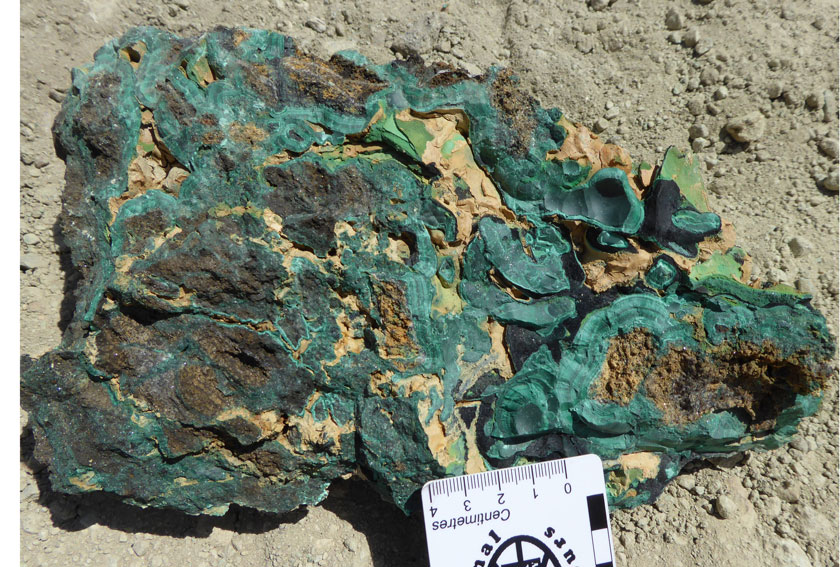
Mutanda supergene mineralisation - a spectacular sample of high grade, shallow supergene mineralisation. Photograph by Mike Porter, 2014.
Mineralisation - Three main ore zones have been delineated. The larger Mutanda East orebody plunges towards the southeast, and has a strike length of ~1400 m, with two stacked bodies (as defined by the 0.4% Cu contour) that dip at between 0 and 30°S (steepening down dip to the south). The upper body is up to 50 m thick near surface, but varies from 0 to 150 m, thickening down dip over an interval of ~500 m, containing three thinner, 0 to 20 m thick, >1% Cu lenses that coalesce up dip. The lower body, as defined by the 0.4% Cu contour, has a similar shape, but is less extensive, persisting down dip for ~400 m and thickening from 0 to 100 m, enclosing two 0 to 75 m thick >1% Cu lenses (Wimberley et al., 2011).
The smaller Mutanda Central orebody, ~50 m to the west, has a strike length of ~500 m, with a down-dip extent of ~250 to 300 m, and dips of 15 to 20°S, as defined by the 0.4% Cu contour. The thickness of the deposit is reasonably constant at ~75 to 100 m, enclosing at least 5 >1% Cu lenses that occupy 75% of the volume of the orebody (Wimberley et al., 2011).
The Mutanda Central Northwest orebody is just to the west of the Central deposit. In section it has an apex down, triangular shape, ~300 m wide and 200 m deep (Wimberley et al., 2011).
The bulk of the mineralisation in Mutanda Central and Mutanda Central Northwest is oxidised although portions contain sulphides. Similarly, much of the upper part of Mutanda East is oxidised, with sulphides appearing at depth and down plunge (Wimberley et al., 2011).
A carbonaceous shale-hosted mineralised zone lies stratigraphically above the main mineralisation (structurally, ~60 m vertically below) the level of the two previous zones. It appears to be variable in thickness and intensity of mineralisation, although grades for both Cu and Co appear to be higher than those in the carbonate hosted sulphide zone (Wimberley et al., 2011).
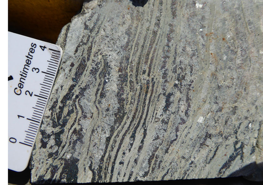
Mutanda hypogene mineralisation - very high grade, banded bornite mineralisation within bedded dolomitic siltstones of the Kansuki Formation. Photograph by Mike Porter, 2014.
The hypogene sulphide minerals, below the zone of oxidation, in order of decreasing abundance, are chalcocite and bornite with minor chalcopyrite. No pyrite has been encountered and the only other sulphide is carrollite. The copper sulphides are generally finely disseminated along bedding planes in the dolomitic argillites and more coarsely so in the dolostone, but also occur in narrow (1 mm) veinlets that cross-cut the bedding. Carrollite has a similar habit and can be difficult to distinguish from the copper minerals where fine-grained. However sub- to euhedral carrollite also occurs as larger, disseminated crystals (up to 3 mm) in both the dolostone and more argillic rocks. In some of the oolitic dolomites, the sulphides preferentially replace the oolites. A less common style of sulphide occurrence is in coarse quartz breccias where there are clasts of very coarse chalcopyrite associated with coarser quartz fragments. In addition to the sulphides there are very sporadic nuggets of native copper (Wimberley et al., 2011).
The principal copper oxide minerals are malachite (Cu2CO3(OH)2) and pseudomalachite (Cu5(PO4)2(OH)4), with heterogenite (CoO.OH) the main cobalt mineral. The dominant gangue minerals are quartz and chlorite, with minor illite and rare talc. Other gangue minerals include Fe-oxyhydroxides (hematite and goethite), AI-oxyhydroxides (gibbsite) and kaolinite. Malachite and pseudomalachite are generally intergrown with quartz, chlorite and goethite (Wimberley et al., 2011).
Published JORC compliant ore reserves and mineral resources at 31 December, 2012 (Glencore Annual Report, 2012) were:
Measured + indicated resources - 124.9 Mt @ 1.93% Cu, 0.67% Co;
Inferred resources - 166.6 Mt @ 1.00% Cu, 0.47% Co;
Proved + probable reserves - 45.9 Mt @ 3.27% Cu, 0.88% Co;
Measured + indicated + inferred resources are distributed as follows (Wimberley et al., 2011) :
Mutanda Central - 20.7 Mt @ 1.28% Cu, 0.81% Co;
Mutanda East - 212.0 Mt @ 1.34% Cu, 0.60% Co;
Mutanda Central Northwest - 66.8 Mt @ 2.10% Cu, 0.55% Co;
TOTAL resources - 299.5 Mt @ 1.48% Cu, 0.59% Co.
Kalumbwe and Myunga (#Location: 10° 46' 22"S, 25° 54' 36"E)
The immediately adjacent Kalumbwe (west) and Myungwa (east) deposits (also known as the MKM deposits) are located ~7 km east of Mutanda, on the tip of an almond shaped, east-west elongated antiform of Roan Group sedimentary rocks on the Kansuki Fault, overlain by Nguba Group rocks.
The copper and cobalt mineralisation at the Kalumbwe and Myunga deposits is stratabound in nature, mostly confined to Mines Subgroup rocks of the Roan Group, with a westerly trend over a strike length of ~1.5 km. Eight separate copper and four cobalt lenses have been identified, with the copper and cobalt mineralisation not always being coincident. Mineralisation is predominantly hosted within fractured, brecciated and silicified dolomite. The primary sulphide mineral assemblage includes chalcopyrite, bornite, covellite, chalcocite, carrollite and linnaeite.
The shallow oxide mineralisation is characterised by supergene enrichment, which can result in elevated copper and cobalt grades, and extends to a depth of ~80 m. The dominant copper and cobalt oxide minerals are respectively malachite and chrysocolla, and erythrite, heterogenite and asbolite.
Published Chinese Resource Standard mineral resources at November, 2011 (China Railway Group Limited) were:
Kalumbwe
Indicated resources,122b category - 0.0269 Mt @ 3.0% Cu & 0.0525 Mt @ 0.55% Co;
Inferred resource 333 category - 0.874 Mt @ 2.86% Cu & 0.967 Mt @ 0.56% Co;
Myunga
Inferred resource 333 category - 0.5536 Mt @ 5.16% Cu & 0.7541 Mt @ 0.51% Co;
TOTAL resource all categories - 1.4545 Mt @ 3.74% Cu & 1.7736 Mt @ 0.54% Co.
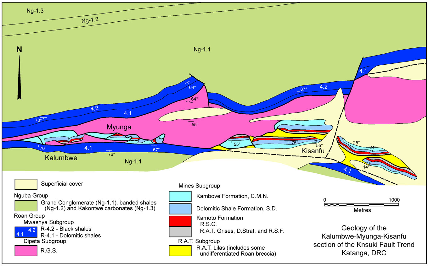
Kisanfu - CuCo Resources (#Location: 10° 46' 20"S, 25° 56' 07"E)
CuCo Resources' Kisanfu resource is located ~1 km east of the Myungwa mine, near the western tip of an almond shaped, east-west elongated antiform of Roan Group sedimentary rocks on the Kansuki Fault, overlain on both flanks by Nguba Group rocks.
The mineralised package that encloses the deposit extends over an east-west strike length of 1.8 km and dips gently to the south over a down dip length of ~900 m, with a thickness of >100 m. It appears to have been dislocated by a series of generally north-south cross faults, stepping down to the east (unlabelled block model from AMEC report to CuCo Resources Limited, 2011).
No other geological detail of the host sequence has been encountered.
Published resource estimates at 2011 (CuCo Resources, March 2011) were:
Unspecified resources - 87 Mt @ 2.87% Cu, 0.17% Co;
Kisanfu - Freeport (#Location: 10° 46' 49"S, 25° 59' 06"E)
Freeport-McMoRan Copper and Gold's Kisanfu deposit is located ~4 km east of Myungwa, also on the tip of an almond shaped, east-west elongated antiform of Roan Group sedimentary rocks on the Kansuki Fault, overlain by Nguba Group rocks. According to Hitzman et al., 2012, the Kisanfu deposits are hosted by the usual Roan Group Lower and Upper Orebody positions within the Kamoto and Dolomitic Shale formations of the Mines Subgroup, but also have relatively significant amounts of mineralisation within the overlying Kambove Formation rocks, the C.M.N., (Calcaire á Minerai Noir). See the Tenke-Fungurume record for details of the stratigraphy of these units.
No other geological detail of the host sequence has been encountered.
Published mineral resource estimates at 31 December, 2012 (Freeport-McMoRan Copper & Gold Inc, Form 10-K report, 2012) were:
Mineralised Material - milling - 56 Mt @ 2.33% Cu;
Mineralised Material - leaching - 52 Mt @ 2.94% Cu;
Mineralised Material - TOTAL - 108 Mt @ 2.62% Cu, 1.08% Co.
Kansuki (#Location: 10° 44' 18"S, 25° 50' 10"E)
The Kansuki deposit lies within a 4 km interval of a 12 km anomalous zone overlying Roan Group rocks along the major, east-west trending 'northern' fault zone described previously, ~10 km west of the southwestern extremity of the Tenke-Fungurume Roan Window. The deposit is ~5.5 km NNE of the Mutanda mine. No geological detail of the host sequence has been encountered.
Published JORC compliant ore reserves and mineral resources at 31 December, 2012 (Glencore Annual Report, 2012) were:
Area 3 - Measured + indicated resources - 17.10 Mt @ 1.70% Cu, 0.17% Co;
Area 1 - Measured + indicated resources - 63.90 Mt @ 1.13% Cu, 0.37% Co;
Area 2 East - Inferred resources - 38.80 Mt @ 0.44% Cu, 0.08% Co;
Area 2 West - Measured + indicated resources - 77.20 Mt @ 0.64% Cu, 0.27% Co;
Area 2 West - Inferred resources - 13.90 Mt @ 0.47% Cu, 0.11% Co;
Kabwimia - Inferred resources - 6.20 Mt @ 0.75% Cu, 0.02% Co.
Information in this summary has in part been taken from Wimberley et al., 2011, "Mineral expert's report: Mutanda", prepared for Glencore International plc by Golder Associates -and- Dixon et al., 2007 "An independent technical report on the material assets of Katanga Mining Limited, Katanga Province, Democratic Republic of Congo" prepared for Katanga Mining Limited by SRK Consulting.
The most recent source geological information used to prepare this decription was dated: 2012.
Record last updated: 31/12/2015
This description is a summary from published sources, the chief of which are listed below.
© Copyright Porter GeoConsultancy Pty Ltd. Unauthorised copying, reproduction, storage or dissemination prohibited.
|
|
|
|
|
Wimberley F, Onley P, van de Schyff, Cunningham E, Eckstein S, Lotheringen J, Anderson S and Johnstone K, 2011 - Mineral experts report: Mutanda (selected excerpts): in Technical report prepared for Glencore International plc by Golder Associates www.hkexnews.hk, 18p.
|
|
Porter GeoConsultancy Pty Ltd (PorterGeo) provides access to this database at no charge. It is largely based on scientific papers and reports in the public domain, and was current when the sources consulted were published. While PorterGeo endeavour to ensure the information was accurate at the time of compilation and subsequent updating, PorterGeo, its employees and servants: i). do not warrant, or make any representation regarding the use, or results of the use of the information contained herein as to its correctness, accuracy, currency, or otherwise; and ii). expressly disclaim all liability or responsibility to any person using the information or conclusions contained herein.
|
Top | Search Again | PGC Home | Terms & Conditions
|
|


