|
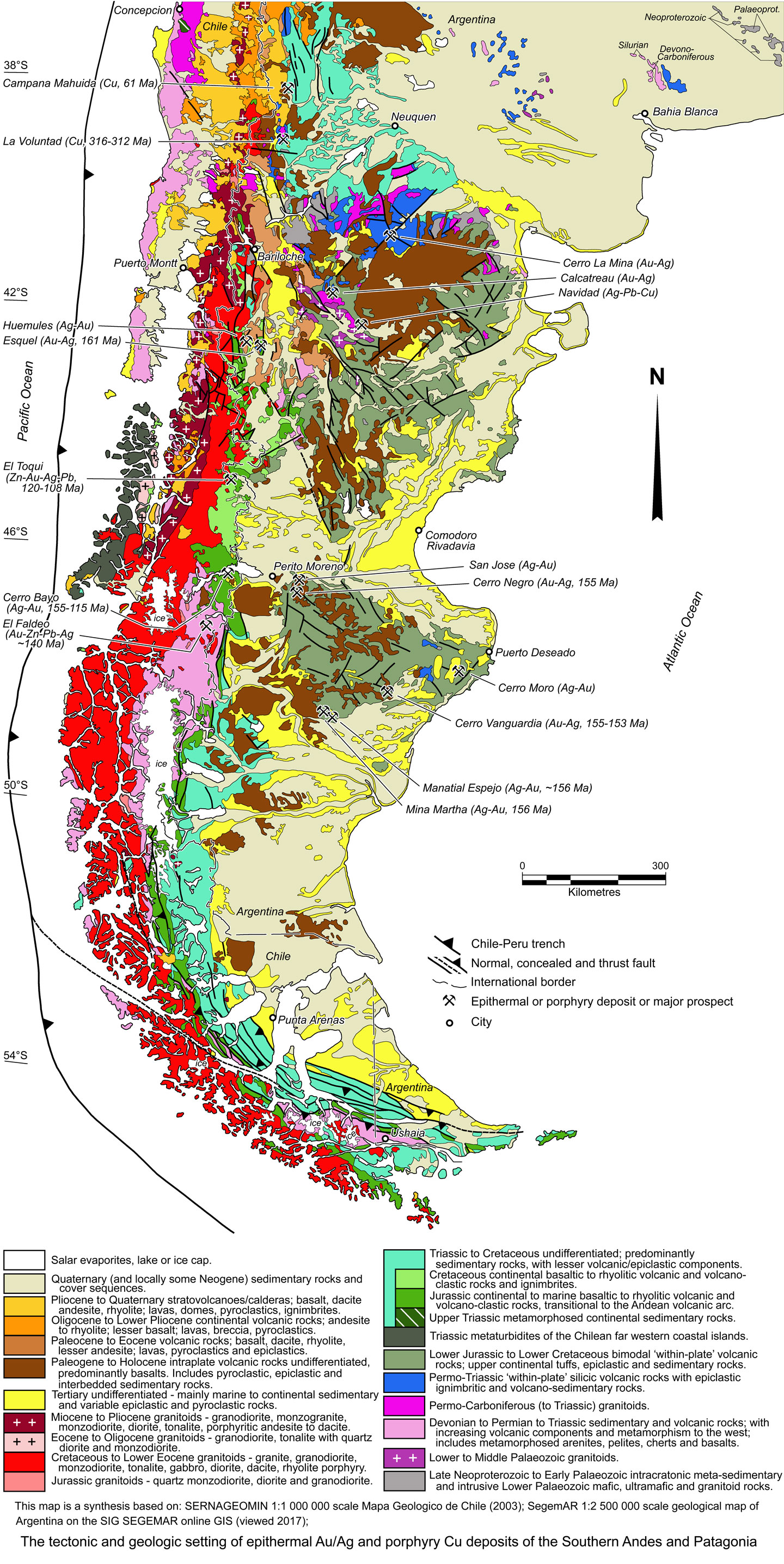
Andean Cu-Au-base metals province - Southern Andes and Patagonia |
|
|
Argentina |
| Main commodities:
Au Cu
|
|
 |
|
|
 |
Super Porphyry Cu and Au


|
IOCG Deposits - 70 papers
|
All papers now Open Access.
Available as Full Text for direct download or on request. |
|
|
The Southern Andean or Patagonian Cordillera (the 'Southern Andes') in Argentina and Chile represents a Jurassic to Recent orogen developed on the western margin of the Patagonia Terrane. The Patagonia Terrane occupies most of Chile and Argentina south of ~39°S, and is a Lower to Late Palaeozoic allochthonous to peri-autochthonous terrane that collided with the south to southwestern margin of Gondwana in the Lower Permian. It is part of the Terra Australis Orogen that had developed along the Pacific margin of Gondwana, and extended over a continuous pre-dispersal length of ~18 000 km and up to 1600 km width, from eastern Australia and New Zealand, the periphery of Antarctica, and along the western fringe of the South American plate. The Pacific margin was the result of rifting associated with the Neoproterozoic break-up of Rodinia. Despite a long history of plate convergence, reorganisation and terrane accretion, the Pacific ocean has never subsequently closed, and the Terra Australia Orogen has been both a passive and active margin at different times and localities since the Lower Palaeozoic (Cawood, 2005).
This record details the tectonic and geological setting of the Southern Andes and Patagonia Terrane as a context to other records covering individual ore deposits within the terrane. For details of the adjoining Central Andes to the north see the Central Andes and Bolivian Orocline record.
Patagonia Terrane
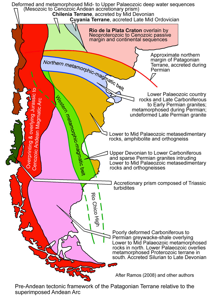
Basement to this terrane is predominantly composed of crystalline, amphibolite facies metamorphic rocks, mainly gneisses, containing peak metamorphic zircons dated at 468.7±4.3 Ma (U-Pb; Pankhurst et al., 2001), and lesser biotite schists, marbles, amphibolites and foliated granitoids. The lower grade schists within this sequence contain ichnofauna that constrain the age of deposition to between Cambrian and Early Ordovician (González et al., 2002). Geochemical data indicate the lower grade metamorphic rocks are derived from marine facies protoliths associated with a magmatic arc, over an attenuated continental crust setting (Cagnoni et al., 1993), and provenance from a Neoproterozoic, possibly Gondwana, source (Ramos, 2008; Ramos and Ghiglione, 2008).
Gravity and magnetic transects demonstrated an asymmetry and linear discontinuity between the thinner Patagonia Terrane and the older, thicker Transamazonian ~2 Ga Río de la Plata craton to the north (Ramos, 1996). The position of the interpreted craton margin and possible suture between the two terranes, is obscured in Chile by younger intrusions, volcanic cover and the coastal accretionary prism ~200 km south of Concepción and may be related to one of two sets of east-west lineaments north and south of Temuca respectively. In Argentina, it is masked by the Tertiary Neuquen and Colorado basins. It crosses the Atlantic coast ~150 km south of Bahia Blanca (Ramos, 2010), and coincides with the Huincul fault, a regional trans-continental strike-slip fault defined in this segment by Ploszkiewicz et al. (1984). It is also seen to truncate the north-south magnetic fabric of the Gondwana margin, including the suture between the Chilenia terrane and the southwestern margin of the Río de La Plata craton where the former has overstepped the Cuyania and Pampia terranes (Dalla Salda and Francese, 1989; Ramos, 2008).
To the north of this craton margin, in Argentina, the Río de la Plata craton is unconformably overlain by a passive margin sequence bracketed between Middle-Late Cambrian and Devonian times. Palaeocurrent analyses of mature orthoquartzites in this sequence indicate a NE to SW transport direction and NE provenance. These are unconformably overlain by arkoses and wackes with Late Carboniferous to Early Permian fauna and a 274±10 Ma upper tuff layer (U-Pb; Tohver et al., 2007), with a SW provenance. This sedimentary source reversal indicates uplift to the SW, culminating in syntectonic sedimentation and a major episode of deformation in the uppermost part of the Lower Permian sequence (López Gamundi et al., 1995) along the Gondwana margin. Deformation lasted at least until Middle Permian, as the complete Early Permian sequence is folded (Ramos, 2008).
An Early Cambrian granodiorite (529±7.5 Ma; Söllner et al., 2000; Charrier et al., 2007), emplaced into what was thought to be a Precambrian gneissic basement has been encountered in deep drilling below the Austral Basin in southern Patagonia, between the western metamorphic-magmatic belt (see below) and the Patagonian Andes. This basement has been shown to be lowest Cambrian (536.8±3.3 to 527.2±5.2 Ma; U-Pb SHRIMP zircon; Hervé et al., 2008). In the same tectonic setting of southern Argentina, the basement Punta Dúngenes Gneiss (649±62 Ma) has been encountered in drilling and in outcrop (Ramos, 2008).
Precambrian basement has also apparently been encountered in drilling over a large north-south elongated area offshore of the Argentine coast from north of Bahia Blanca to Puerto Deseado, where it has a north-south structural grain. These occurrences are most likely related to basement rifted from the Kalahari Craton of Southern Africa during the opening of the Atlantic Ocean (Ramos, 2008). Late Mesoproterozoic basement is evident in the Falkland (Malvinas) Islands further to the SE (see the Scotia Plate and fringing islands section below).
 Click here to expand image
Two mid to late Palaeozoic metamorphic-magmatic belts have been superimposed on the basement rocks of the Patagonia Terrane to the south of the southern margin of the Río de la Plata craton.
• The northern metamorphic-magmatic belt, which is >100 km wide, trends generally east-west in the northern Patagonian Andes in Chile, to WNW-ESE in eastern Argentina, and is sub-parallel to, and up to 100 km inboard of the northern margin of the Patagonia Terrane. It is characterised by a NW aligned metamorphic fabric and amphibolite facies orthogneisses. These gneisses have Late Carboniferous to early Permian metamorphic ages of 304 and 281 Ma (Basei et al., 2002), and are hosted within probable early Palaeozoic amphibolite, marble and phyllite, and are unconformably overlain by Silurian to Early Devonian orthoquartzites deposited in a passive margin setting (Ramos, 2008). These rocks are cut by undeformed, 244±9 Ma Late Permian granitoids, lacking the metamorphic fabric of the orthogneisses (Ramos, 2008; Ramos and Ghiglione, 2008).
These observations would be consistent with the northern metamorphic-magmatic belt being the result of a south dipping oceanic plate, attached to the passive Río de la Plata craton margin, being subducted below the approaching Palaeozoic Patagonian Terrane, with deformation of a thick accretionary wedge, imbrication, metamorphism, magmatism and subsequent relaxation, uplift and exhumation of rocks from deeper crustal levels during Mesozoic extension.
• The western metamorphic-magmatic belt is also 100 to >150 km wide. It intersects the northern belt near the Chile-Argentina border north of Bariloche, and trends generally SSE to the east of the Patagonian Cordillera of the Andean chain, obliquely crossing the Atlantic coast south of Comodoro Rivadavia, ~1000 km to the south. This belt coincides with the Río Chico structural high dividing the post Mesozoic San Jorge Basin. This high continues
southwards for a further 500 km as the offshore Punta Dúngenes structural palaeo-high that separates the the post Mesozoic Austral and Malvinas basins (Galeazzi, 1996).
Within the western metamorphic-magmatic belt, redschist to amphibolite facies metamorphic rocks, including muscovite-chlorite schists, metaquartzites,
and tourmalinite strata-bound schists, are associated with foliated tonalites, granodiorites and two-mica granites, mylonites and granitic cataclasites. The main metamorphic episode is syntectonic, accompanied by significant anatexis, with a 310 to 325° trending main foliation. The protoliths of some of these metamorphic rocks can be demonstrated to be shales, sandstones and greywackes. These rocks have been shown to be no older than ~473 Ma, whilst granitoids to the south are mainly early Palaeozoic, ranging in age between 472 and 454 Ma (Loske et al., 1999). However, the majority of the metamorphic and igneous rocks are dated in the range 375 to 310 Ma in the Upper Devonian to Mid-Carboniferous, with interspersed Early Permian 290±3 Ma two-mica granite (U-Pb zircon; Varela et al., 2005) and deformed leucogranite associated with migmatite, dated at 289±2 Ma (U-Pb; Pankhurst et al., 2006).
To the west of the northern to central section of the western metamorphic-magmatic belt, an up to 5000 m thick sequences of greywackes, shales and diamictites are encountered (Page et al., 1984), containing brachiopod fauna indicating an Early Carboniferous to Early Permian age (Andreis et al., 1987). The rocks are mildly deformed, generally postdate an early Palaeozoic deformation, and are intruded by 243 to 211 Ma tholeiitic gabbros (K-Ar; Page, 1984; Poma, 1986). Sedimentary structures in these Early Carboniferous to Early Permian sequences indicate dominant palaeo-currents from NE to SW, suggesting derivation from an uplifted highland in the vicinity of the western metamorphic-magmatic belt during and after the period it was undergoing metamorphism and magmatism from the Devonian to mid Carboniferous.
The presence of Precambrian and Lower Palaeozoic basement to the west of the western metamorphic-magmatic belt (Ramos, 2008), as detailed above opens the possibility that the belt is the product of Devonian to Carboniferous collision between the main Palaeozoic Patagonian Terrane to the east and an exotic Precambrian terrane in western Patagonia. The latter may be a sliver related to the Rodinia breakup, analogous to the exotic terranes that make up most of the basement of the central Andes in central and northern Chile. The metamorphism, anatexis and magmatism of the western metamorphic-magmatic belt would be consistent with continent-continent collision, intense imbrication, and subsequent relaxation, uplift and exhumation of rocks from lower crustal levels during Mesozoic extension.
 The Pre-Andean Tectonic Cycle, lasted from the latest Permian to the earliest Jurassic, an interval of ~55 m.y., from ~240 to 194.5 Ma, following the amalgamation of the Patagonian Terrane with Gondwana and the final assembly of the Pangea super-continent. This cycle is characterised by post-accretion continental-scale extension and rifting, accompanied by crustal up-warping of the brittle upper crust, which peaked by the end of the Triassic in central and northern Argentina and Chile (Mpodozis and Ramos, 2008). This resulted in the development of rift basins filled with continental successions and associated widespread bi-modal Permian to Triassic magmatic activity. For an explanation of the regional setting and tectonic activity involved see the Pre-Andean Tectonic Cycle section of the Central Andes and Bolivian Orocline record.
Magmatism is best developed on the northwestern margin of the Patagonian Terrane, in the northwestern quarter of the Somún Cura (or North Patagonian) Massif, comprising rocks of the Choiyoi Group and equivalents. However, exposures further south in the Deseado Massif suggest they may continue under cover over a much larger area. These succesions overlie a basement of Palaeozoic metamorphic rocks intruded by extensive Early Permian Granites related to the arc involved with the collision of the Patagonian Terrane and the Rio de la Plata Craton to the north. In this regions, the Permo-Triassic rocks have either been mapped as the regional Choiyoi or local Los Menucos Group. The latter is composed of two units. The lower of these, the Vera Formation comprises a flat-lying to gently-dipping sedimentary sequence of conglomerates, wackes, shales and sandstones with interbeds of volcanic ash, fossiliferous (Late Triassic) tuffs, pyroclastic flows and volcanic breccias. Individual beds are often only several metres in thickness and generally lack a significant lateral extent, deposited in an environment of volcanic cones, flood plains, ephemeral rivers and small lacustrine basins. The unconformably overlying Sierra Colorada Formation is predominantly composed of rhyolitic volcanic and volcaniclastic rocks, comprising lavas, tuffs and poorly-stratified volcanic breccias.
Palaeozoic basement to these volcanic units is cut by dykes and dyke swarms of andesite and trachyandesite, with lamprophyric varieties, and minor rhyolites intruded over an area of ~100 x 35 km within the Somún Cura Massif. A Middle Triassic crystallisation zircon age (U-Pb LA-MC-ICPMS) of 243.6±1.7 Ma has been obtained for one of these trachyandesite dyke (Gonzalez et al., 2016). Gonzalez et al. (2017) have dated volcanic rocks that are not easily differentiated from those of the overlying Jurassic Chon Aike Large Igneous Province at Late Triassic ages between 247 (U-Pb and K-Ar) and 202 Ma (K-Ar) that are most likely related to the dyke swarm and are correlates of the Choiyoi/Los Menucos Group. The same authors refer to these volcanic and intrusive rocks as the Monasa Formation, which are found towards the Atlantic Ocean margin of the Somún Cura Massif, east of the main Choiyoi/Los Menucos Group exposures. Permo-Triassic granitoids are part of an extensive plutonic-volcanic complex of wide-ranging composition along the western margin of the Somún Cura Massif, and have been attributed to the Choiyoi Group (Pankhurst et al., 1998).
Over 300 km to the south of the Somún Cura Massif, beyond the intervening post-Jurassic San Jorge Basin, the Deseado Massif has a Palaeozoic metamorphic basement comprising the La Modesta Formation (or Rio Deseado Complex) phyllites, quartzites, schists, amphibolites, gneisses and migmatites. These older rocks are intruded by granites of Lower (Ordovician) to Middle (Late Devonian to Permian) Palaeozoic age. They are, in turn, unconformably overlain by red conglomerate, arkose, shale and tuff of the Permian La Golondrina and Mid- to Upper-Triassic El Tranquilo Formations, which were deposited in a series of graben and half-graben structures and lack a major volcanic component. They are, however, intruded by Late Triassic and Early Jurassic granite of the Central Patagonian Batholith (Sripanicic et al., 1972; Rapela et al., 1991).
The regional Permo-Triassic Choiyoi Group represents the first of three large igneous provinces exposed in the Somún Cura and Deseado massifs of Argentina and is overlain by intervening younger cover. It reflects the final stages of accretion, and then extension related to the initiation of the breakup of the Pangea super-continent. The Choiyoi Group and equivalents extend northward onto the Rio de la Plata Craton, and to the northwest into Chile. In north western Argentina near Mendoza it comprises three stages. The first is characterised by mafic to intermediate breccias and lava flows deposited in a magmatic arc developed on continental crust on the active Gondwana margin. The second stage comprises felsic to intermediate and continental sequences in a mature volcanic arc with incipient extension and intraplate magmatism. The final stage includes welded tuffs, lava flows and sub-volcanic bodies with associated calderas, occurring as widespread intraplate volcanism extension and rift development (Strassere and Gregori, 2007). In the Somún Cura Massif, it appears to accompany the post-collision relaxation following the accretion of the Patagonian Terrane to the Rio de la Plata Craton, and then the extension related to the initiation of breakup of Pangea.
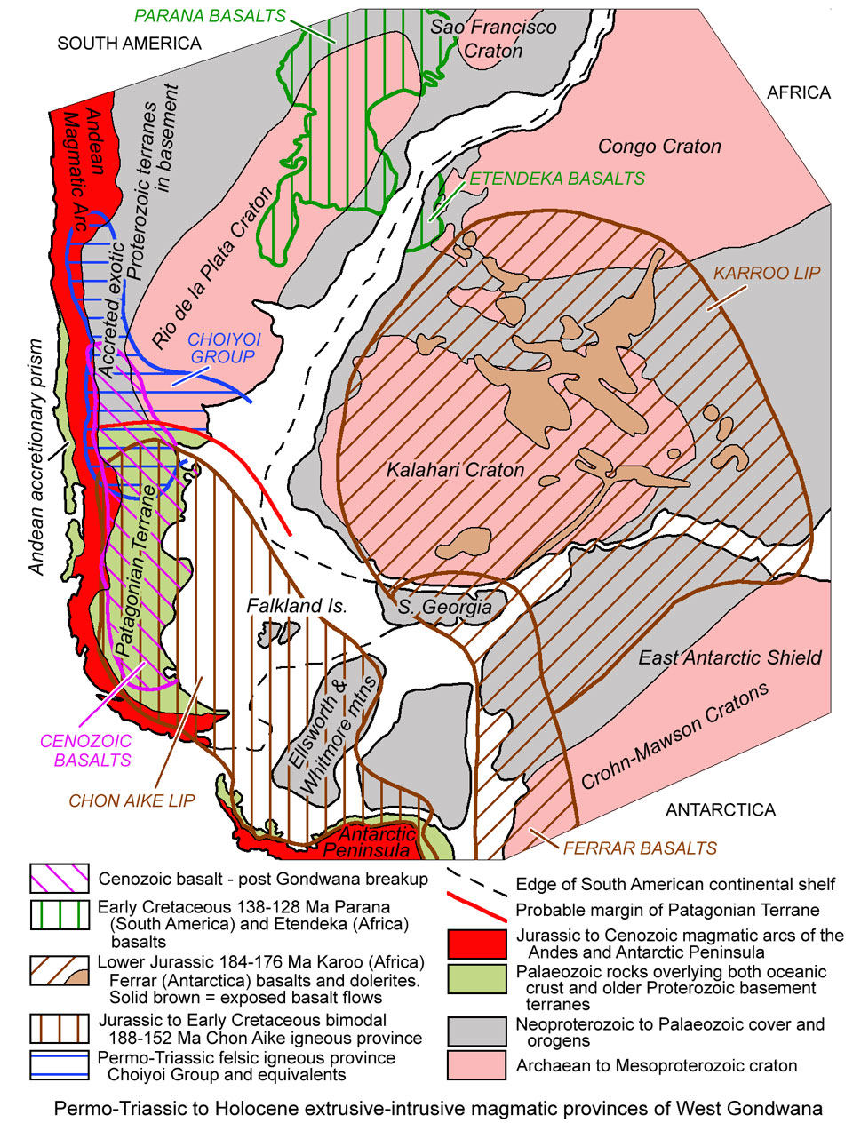 Mesozoic Chon Aike Large Igneous Province - All of the rock packages described above are overlain by a >700 000 km2 sheet of Early Jurassic to earliest Cretaceous volcanic rocks of the Chon Aike Large Igneous Province, dominated by rhyolitic ignimbrites, which form a bimodal association with mafic and intermediate lavas and pyroclastics (Poblete et al., 2014; Pankhurst et al., 1998). These rocks represent the second of the three large igneous provinces of the Patagonia Terrane. They are broadly coeval with the Jurassic Karoo basalts (183.8±2.4 Ma to 176.2±), Ferrar basalts (~184 to ~177 Ma) and successor Early Cretaceous (138 to 128 Ma) Parana-Etendeka basalt provinces of southern Africa, Antarctica-Tasmania and Brazil-Namibia respectively. All of these large igneous provinces were regionally contiguous prior to the Gondwana break-up, and are coincident with pulses of extension during the early stages of that break-up (Storey et al., 1996), prior to the final separation of Africa and South America at ~100 Ma.
Much of the Patagonia Terrane to the east of the main Andean Cordillera is masked by Late Mesozoic and Cenozoic cover, framing the two more stable 60 000 km2 Deseado and ~100 000 km2 Somún Cura (or North Patagonian) massifs in the central to southern and northern part of the terrane respectively. Chon Aike Large Igneous Province volcanic piles are exposed in these two massifs, but are also present beneath Cretaceous and Tertiary marine and lacustrine sedimentary cover in the intervening ~300 km subsided interval (the San Jorge Basin), and to the south of the Deseado Massif below the Austral Basin.
The Chon Aike sequence includes volcanic and volcaniclastic rocks, cut by dykes which are overlain by rhyolitic domes. Pyroclastic rocks predominate, with ~85% ignimbrites, subordinate lacustrine epiclastic deposits, laminated tuffs, air-fall tuffs and intercalated lavas. The sequence varies from 300 to >1100 m in thickness. East to west diachronism is recognised, with an Early to Middle Jurassic 188 to 178 Ma pulse in eastern Patagonia, interpreted to represent widespread crustal anatexis related to extensive mafic underplating shortly after the Karoo and Ferrar mafic magmatism (Pankhurst et al., 1998). This was followed by Middle Jurassic to earliest Cretaceous volcanism from 172 to 162 Ma and further west, 157 to 152 Ma in the eastern Andean foothills. The latter, which constitute the Ibáñez and Tobífera formations to the north and south respectively, overlie a Palaeozoic metamorphic basement (Parada et al., 1997) and were locally faulted, tilted and thrust during Cretaceous to Tertiary Andean deformation (Suárez and De la Cruz, 2000) along the Patagonian Cordillera.
This transition from east to west is accompanied by a change in geochemical characteristics, from relatively high-Zr and -Nb types in the east to subalkaline arc-related rocks in the west. However, the dominance of rhyolites remains as a characteristic. All of the mafic rocks are well fractionated in contrast to direct mantle derivatives. Petrogenetic studies favour partial melting of immature lower crust due to the intrusion of basaltic magmas, with subsequent fractionation by crystal settling or solidification and remelting. The formation of large amounts of intracrustal silicic melt acted as a density barrier against the further rise of mafic magmas, which are thus rare in the province (Pankhurst et al., 1998).
While extension took place in the east, and the Patagonia Terrane was migrating westward, the Phoenix oceanic plate to the west was being subducted beneath it, forming a magmatic arc in what was to become the Andean Orogen. The Chon Aike and Andean magmatic arc sequences coalesced within the Ibáñez, El Quemado and Tobífera formations that straddle the transition between the two regimes (Pankhurst et al., 1998). However, the Jurassic Andean Arc is also interpreted to have been extensional in character, a product of east-directed, Marianas-type subduction characterised by a steeply inclined slab, rolling back faster than the Patagonian Terrane approached (Mpodozis and Ramos, 1990).
To the north, in the Somún Cura Massif (see Current Tectonic setting image below), the Jurassic Chon Aike Large Igneous Province is represented by two main formations which overlie a Palaeozoic metamorphic basement and Permo-Triassic volcanic and sedimentary sequences. These are the:
• Marifil Formation which occupies the eastern half of the massif, predominantly to the ENE of the major NW-SE trending transcontinental shear zone, the Gastre Fault zone (see Current Tectonic setting), which extends from the Andean Cordillera to the Atlantic coast in Central Patagonia. This structure largely parallels the southwestern margin of the Somún Cura Massif and is estimated to have accommodated ~500 km of dextral displacement during Early to Middle Jurassic times.
The Marifil Formation has been dated (Rb–Sr whole-rock) at from 183±2 to 178±4 Ma (Rapela and Pankhurst, 1993). It comprises 600 to 900 m of flat lying, rhyolitic ignimbrite sheets with associated volcaniclastic deposits and lava flows. Pyroclastic deposits predominate over tuffs and lavas, although the latter are volumetrically significant. Ignimbrites form cooling units up to 100 m thick and cover an area of >50 000 km2 in the eastern Marifil Formation where flat lying ignimbrite sheets predominate. These ignimbrites are estimated to have been erupted from large (~100 km diameter) calderas (Aragon et al., 1996). Tuffs, lapilli-tuffs and volcanic agglomerates are interbedded with the ignimbrites, and the sequence is cut by subvolcanic intrusions, including dacitic and andesitic dykes, which are comagmatic with the ignimbrites (Rapela and Pankhurst, 1993). Clastic sedimentary intercalations are much less common than in the equivalent Chon Aike Formation of the Deseado Massif to the south.
• Lonco Trapial Formation, which is 500 to 800 m thick and is largely restricted to an ~200 km wide zone that covers ~40 000 km2 (Page and Page, 1993) straddling the broad Gastre Fault zone along the western and southern margins of the massif. This fault zone represents a zone of rifting and a series of NW-SE elongated Jurassic half-grabens developed on the margin of the massif, which were inverted during the Cenozoic. It comprises a sequence of lavas and volcaniclastic rocks with sedimentary intercalations. Lavas are mostly thin (<1 m) and have mafic compositions, with pyroxene, olivine and biotite. The breccias and agglomerates are predominantly intermediate with plagioclase and amphibole phenocrysts, and crop out as thick beds with poor stratification. There are abundant hypabyssal rhyolitic intraformational dykes and small stocks, which are flow-banded, with quartz and K feldspar phenocrysts. Remnant volcanic structures reflect central volcanic edifices, with known subvolcanic polymetallic, Au-bearing, mineralised veins spatially associated with the largest andesite masses (Marquez et al., 1988). Vein mineralisation is also associated with some of the rhyolitic dykes, as are small trachyte, trachyandesite and trachybasalt domes (Haller et al., 1990).
While the Marifil Formation is directly covered by Cretaceous continental sediments, the Lonco Trapial Formation is transitional with the overlying Mid to Late Jurassic Cañadón Asfalto Formation. The contact locally occurs as erosive or angular unconformities, although these discontinuities are typical of high-relief volcanic environments and therefore regarded as lacking regional significance. The Cañadón Asfalto Formation comprises fluvial, lacustrine and volcanic facies with a high volcaniclastic input. It commences with ~170.9±4.4 Ma basaltic flows and evaporitic carbonates, overlain by a series of black shales and airfall tuffs passing up into intercalated shales and sandstones (Scasso et al., 2015). This sequence is unconformably overlain by the Cañadón Calcáreo Formation, a deltaic to fluvial sequence, deposited at ~156 Ma, then by post-rift Cretaceous fluvial, lacustrine and estuarine sediments (Scasso et al., 2015). All of these sequences were overlain by Cenozoic marine and continental deposits as well as extensive sheets of Eocene to Pleistocene mafic igneous rocks.
Within the Deseado Massif the Lower to Late Jurassic Chon Aike Large Igneous Province is represented by the Bahía Laura Volcanic Complex which is dated at between 187 and 151 Ma (Haller, 1997).
The Bahía Laura Volcanic Complex has been subdivided as outlined below after Sharpe et al. (2002); Páez et al. (2010) Guido and Jovic (2014) and others. The thickness, character and dominance or absence of individual lithofacies and units varies across the massif. The sequence has been studied at a number of epithermal Au-Ag deposits within the massif, some of which are referenced below with embedded links to more detailed descriptions:
• Roca Blanca Formation, the lowest exposed unit, comprising ~990 m of Lower Jurassic sandstones and sandy tuffs;
• Bajo Pobre Formation, which is characterised by intermediate to basic lavas with subordinate ash flow tuffs and volcanic
agglomerates, and has a total thickness of between 200 and possibly 600 m. The sequence varies from mixed tuffs, lava flows and sub-volcanic intrusives at Cerro Moro towards the Atlantic coast, to amygdaloidal basalts and basaltic-andesites at Cerro Vanguardia, 200 km to the WSW, in the centre of the massif. A further 130 km to the WSW at Manantial Espejo, towards the south-western margin of the massif, the sequence includes agglomerate and clastic facies. At Cerro Negro, 350 km NW of Cerro Vanguardia, near the north-western extremity, the same unit comprises porphyritic and trachytic textured hornblende-pyroxene-magnetite basaltic-andesite lava flows and lahar agglomerates.
However, Guido and Jovic (2014) and Longo 2013 at Cerro Vanguardia and Cerro Negro respectively, have recognised a second separate andesitic unit mapped as Bajo Pobre Formation, which lies within the upper sections of the stratigraphically overlying Chon Aike Formation. This would explain the dating of Bajo Pobre Formation basalt at 156±2 Ma (Ar-Ar on feldspar; Alric et al., 1996), younger than Rb-Sr dates from the Chon Aike Formation.
• Chon Aike Formation, predominantly Middle to Upper Jurassic in age, dated of 162±11 Ma (Rb–Sr whole-rock; De Barrio, 1993) for the western section of the massif, and 168±2 Ma for the eastern exposures around Puerto Deseado (Pankhurst et al., 1993), whilst accompanying fossil flora is consistent with a Middle to Late Jurassic age (De Barrio et al., 1982). It comprises rhyolites which have calc-alkaline, peraluminous and high potassium signatures, accompanied by minor dacites and trachydacites. These extrusives built an extensive rhyolitic plateau, dominated by large volumes of pyroclastic material (~85% ignimbrites with subordinate intercalated lavas) erupted as high fluidity ash flow tuffs (Pankhurst et al., 1998; Panza and Haller, 2002; Guido, 2004).
As with the other units within the Bahía Laura Volcanic Complex, the component units and lithofacies are variable across the massif. At Cerro Negro in the NW of the massif, the Bajo Pobre Formation andesites are overlain by rhyolitic flow domes and lavas, followed by welded hornblende-pyroxene dacitic ignimbrites, overlain, in turn, by a porphyritic andesitic domes, lava flows and lahar agglomerates. The andesitic unit has been dated at 159±2.1 Ma (U-Pb zircon; Lopez, 2006). These are succeeded by a thinner development of dacitic and trachyandesitic flow domes and dacitic ignimbrites. The formation then includes fluvio-lacustrine deposits during the waning stages of acidic volcanism, occurring as mounds and graben fill and includes chalcedonic and travertine mounds, opalite layers and waterlain sediments containing pyritic white clay and advanced argillic altered tuff. These are capped by rhyolitic flow domes and ignimbrites and rhyolitic to dacitic ignimbrites.
At Cerro Vanguardia, the sequence is described as of rhyolitic composition, accompanied by minor dacites and trachydacites, but dominated by large volumes of pyroclastic material, ~90% ignimbrites with subordinate intercalated lavas. Guido and Jovic (2014) describe intermediate to basic calc-alkaline, mostly andesitic, volcanic rocks, dominated by lavas, with subordinated ash flow tuffs and agglomerates in the upper sections of the formation. At Manantial Espejo, the Bajo Pobre Formation andesites are overlain by a succession of ignimbrites that commence with dacitic and then rhyolitic compositions, followed by bedded tuffs with a travertine layer interpreted to be related to host springs activity, similar to that at Cerro Negro. These are succeeded by a suite of rhyolitic flow domes and ignimbrites, debris flow breccias and an intercalated andesitic lava layer. The travertine and sinter mounds/layers are interpreted to be the surface expression of the epithermal mineralising fluids.
• Cerro León Formation, typically porphyritic subvolcanic laccoliths, sills and dykes, which de Barrio et al., (1999) and Jovic et al. (2008) regarded as representing feeders and intrusive equivalents of the andesitic, dacitic and rhyolitic flows, ignimbrites and pyroclasics. Dactic and rhyolitic dykes attributed to the Cerro León Formation cut through into the highest volcanic member of the Chon Aike Formation (Guido and Jovic, 2014);
• La Matilde Formation, a homogeneous Upper Jurassic sequence of ash fall tuffs and reworked volcaniclastic sediments deposited in low energy fluvial and lacustrine settings, with minor ash flow and air fall tuff intercalations. It is intercalated with and partially a lateral equivalent of the upper ignimbrites of the Chon Aike Formation in some areas, although the two units are apparently in unconformable contact in other areas (de Barrio et al., 1999; Paez et al., 2010).
The sequence described above is unconformably overlain by sandstone and course clastic sedimentary rocks of the Lower Cretaceous Bajo Grande Formation.
In the Andean Foothills of Chilean Patagonia, the Chon Aike Large Igneous Province is represented by the Jurassic Ibáñez, El Quemado and Tobífera formations that are lateral equivalents from north to south. They consist mainly of silicic volcanic rocks, comparable to those of the Chon Aike Formation, although more andesitic in character. They also differ in that they have been faulted, tilted and thrust as a result of Cretaceous to Tertiary Andean deformation.
The Ibáñez Formation to the north, is represented in the Cerro Bayo district by a sequence that commences with ~110 m of andesitic to dacitic lavas and volcaniclastic successions; ~150 m of variably welded rhyolitic to rhyodacitic pyroclastic fragmental succession; ~20 to 60 m of volcanosedimentary dominated rocks containing laminated volcaniclastic sandstones to conglomerates; and up to 300 m of variably welded rhyolitic to rhyodacitic pyroclastic deposits. The type section of the El Quemado Formation is ~235 m thick, composed of six massive ignimbrite units tilted at about 40° and cut by subhorizontal thrusts. The Tobífera Formation further to the south, largely lies beneath the sedimentary cover of the Austral/Magallanes basin. It is predominantly composed of subaqueous pyroclastic and volcano-sedimentary rocks, including bedded ash fall tuffs, thin tuff turbidites composed of rhyolitic debris and massive polymict debris-flows containing blocks of rhyolite. Penecontemporaneous rhyolitic intrusions occur as both cross-cutting hypabyssal intrusions and peperite breccias emplaced into wet sediments. Pillowed basaltic lavas are also encountered (Wilson, 1991; Hanson and Wilson, 1993).
Cover Sequences - Much of the Patagonia Terrane to the east of the main Andean Cordillera is masked by Mesozoic and Cenozoic cover, framing the Deseado and Somún Cura (or North Patagonian) massifs in the central to southern and northern part of the terrane respectively. Sedimentary cover occurs as the generally WNW-ESE aligned San Jorge Basin which separates the two massifs, and the NNW to SE elongated Austral/Magallanes Basin to the SW of the Deseado Massif. Miocene foreland basins were developed to the east of the Andean Orogen, forming part of the Austral Basin and string of lesser basins to its north. The third of the three large igneous provinces of the Patagonia Terrane is represented by an extensive volcanic plateaux comprising Late Cretaceous, Late Oligocene to Early Miocene and Late Pliocene to Holocene 'in-plate' mafic lavas and subordinate ignimbrites which occur both within the basins and over the massifs covering much of Patagonia east of the Andes (Bermúdez et al., 1993; Kay and Copeland, 2006).
Southern or Patagonian Andes
The Southern or Patagonian Andes, which occupy the western margin of the Patagonian Terrane, have been uplifted, and largely comprise the 100 to 150 km wide, composite, Patagonian Batholith that extends for ~2000 km, from 39 to 55°S. In the north, three pulses of intrusion are recognised, although remnants of Carboniferous (335 to 320 Ma, U/Pb in zircons; Pankhurst et al., 2005) basement granitoids are also found within its confines. The main pulses are i). Jurassic to Cretaceous (170 to 90 Ma, K/Ar; Lizuaín, 1981; González et al., 1984); ii). Paleogene (55 to 37 Ma, K/Ar); and iii). Middle Miocene (13 to 15 Ma, K/Ar; González et al., 1984). To the south, the central segment of the batholith, between 43°30' to 46°30' S, comprises pulses of Early Cretaceous (140 to 124 Ma, Rb/Sr), younging eastward to Middle Cretaceous (117 to 98 Ma; Pankhurst et al., 1999), with a series of minor 110 to 87 Ma (K/Ar and U-SHRIMP) stocks east of the main batholith (Ramos, 1981; Ramos et al., 1982; Rolando et al., 2002). The southern section of the batholith commences with Late Jurassic 157 Ma bimodal leucogranites and gabbros along the Magellan Strait, passing northwards into 145 to 137 Ma Cretaceous varieties, and late 136 to 111 Ma Early Cretaceous granitoids along the western margin, and then Late Cretaceous 99 and 78 Ma plutons at about 52° 45'S. Cenozoic plutons in this part of the batholith, are confined to the axial zone, emplaced in two pulses, i). Paleogene, between 65 and 40 Ma; and ii). Neogene leucogranites, from 22 and 16 Ma (U-SHRIMP in zircons; Hervé et al., 2004).
The batholith largely comprises a series of plutons of granodioritic, tonalitic and dioritic composition, with Late Miocene to early Pliocene leucogranites (Pankhurst et al., 1999), whilst to the south of 47°S, gabbroic to granitic plutons predominate (Moreno and Gibbons, 2007).
Along its western margin between 43° 30' and 48°S, the batholith intrudes 256 to 195 Ma Middle Triassic to Early Jurassic fore-arc accretionary complex (prism) rocks, comprising variable limestones, turbidites, pelagic cherts and variable MORB basalts, with fault controlled slivers of blue- and red-schist rocks (Thomson and Hervé, 2002). To the north of 43° 30', the country rocks to the west of the batholith comprise a sequence of Devonian to the Triassic pelites, cherts and amphibolites, with minor ultramafic rocks, that were deformed and metamorphosed between the Permian and Jurassic. These rocks may also be interpreted to represent an accretionary prism related to Andean subduction principally during the early Mesozoic to late Cenozoic.
In contrast the rocks intruded along its eastern margin are of 364 to 250 Ma, Late Devonian to Permo-Triassic age, characterised by a thick sequence of clastic turbidites and isolated recrystallised limestones with large scale folding and low grade metamorphism (Thomson and Hervé, 2002), and by Jurassic felsic volcanic rocks that are time equivalents of the largely rhyolitic succession of the Mesozoic Chon Aike large igneous province. The batholith intrudes and obliterates the boundary between the predominantly Palaeozoic cratonic basement of the Patagonia Terrane and the Proterozoic basement rocks of the Chilenia Terrane to the north in Central Chile (Hervé et al., 2008).
Most of the foothills on either side of the northern Patagonian Andes are composed by thick Paleogene andesitic volcanic sequences and associated volcaniclastic rocks, with some intercalated marine deposits (González Bonorino, 1973). Late Oligocene to Early Miocene marine deposits on both slopes of the cordillera suggest that Pacific transgressions were able to go across the Andes, prior to uplift and erosion (Ramos, 1982). The Central Depression persists south from the Central Andes into the northern section of this interval, filled by Miocene to Pliocene and Recent unconsolidated pyroclastic and sedimentary rocks, before pinching out to the south.
In the central section of the batholith, Paleogene volcanic and plutonic rocks are absent from both slopes of the Patagonian Cordillera, which are characterised by thick sequences of Middle to Late Jurassic to Early Cretaceous andesitic volcanic and volcaniclastic rocks overlying deformed Late Palaeozoic sedimentary rocks (Ramos, 1979; Haller and Lapido, 1980; López Gamundi, 1980; Suárez and de la Cruz, 1997). Marine volcano-sedimentary sequences are found on the western margin, and continental suites to the east, suggesting the range formed an emergent barrier. In the southern part of the ranges, minor overlying synorogenic Paleogene and Miocene sequences are again evident over and flanking the batholith (Ramos and Ghiglione, 2008).
A chain of at least, 60 historically and potentially active Late Cenozoic stratovolcanoes in Chile and Argentina commences in the northern part of the terrane, south of the volcanic gap associated with flat slab subduction on the southern section of the Central Andes. These volcanoes were emplaced over exhumed rocks of the Patagonian Batholith, and are predominantly found along the western slope of the Southern Andes. There is a <50 km long gap at ~46 to 49°S, adjacent to the Chile Rise-Trench triple junction, where the ~east-west oceanic volcanic ridge separating the Nazca and Antarctic oceanic plates is being subducted below the South American plate (Stern, 2004). The volcanoes are predominantly Late Oligocene to Late Miocene north of 38°S, and Late Cretaceous and Late Miocene south of that latitude (Folguera and Ramos, 2011).
Crustal thickness decreases southwards from >50 km on the southern end of the Central Andes, to ~30 to 35 km below the Patagonian Andes where Pre-Andean basement ranges from Palaeozoic to early Mesozoic (Munizaga et al., 1988; Nelson et al., 1999). Over most of this interval, the up to 45 Ma Nazca plate is being subducted below the continent at 7 to 9 cm/yr at an angle of 22 to 30° NE of orthogonal with the trench. In the central and southern Patagonian Andes, where the crust is relatively thin, tholeiitic and high-Al basalts and basaltic andesites are the dominant rocks type erupted from the stratovolcanoes and many minor eruptive centres, although andesites, dacites and rhyolites also occur (Stern, 2004 and references cited therein).
Climate, Erosion and Uplift
The transition from the Central to Southern Andes coincides with both the northern margin of the Patagonia Terrane, and the dividing line between the influence of the moist westerly wind weather pattern to the south and the dominant tropical atmospheric circulation cell between the equator and the sub-tropics that produces the 'SE Trade Winds'. The latter results in much of the high central Andes being in a rain shadow, producing a very arid landscape with low weathering and erosion rates. In contrast, the westerly weather pattern that affects the Patagonian Andes results in a high rainfall on the western slopes of the uplifted range and greater erosion rates, delivering much larger volumes of sediment fill to the trench, which, in turn, lubricates the subduction channel. This reduces the coupling between the continental upper plate and the subducted slab, producing a narrower mountain range (Ramos and Ghiglione, 2008). However, the Central Depression separating a Mesozoic Coastal and eastern Main Cordillera in the Central Andes persists south into the northern Patagonian Andes for several hundred kilometres, before the two ranges merge to become a single narrower cordillera.
Tectonic uplift of the Patagonian Cordillera was initiated during the Miocene, with most of the western slope of this part of the cordillera being subjected to an extreme erosional gradient, that, in turn, induced a yet higher rate of isostatic uplift. This enhanced uplift and erosion resulting in the stripping of the capping volcanic sequences of the magmatic arc to expose the root batholith. Volcanic facies of the magmatic arc are only preserved on the eastern margins of the batholith. This enhanced uplift and erosion removed much of the porphyry and porphyry-epithermal environment, except in the north in the transition to the more arid central Andes.
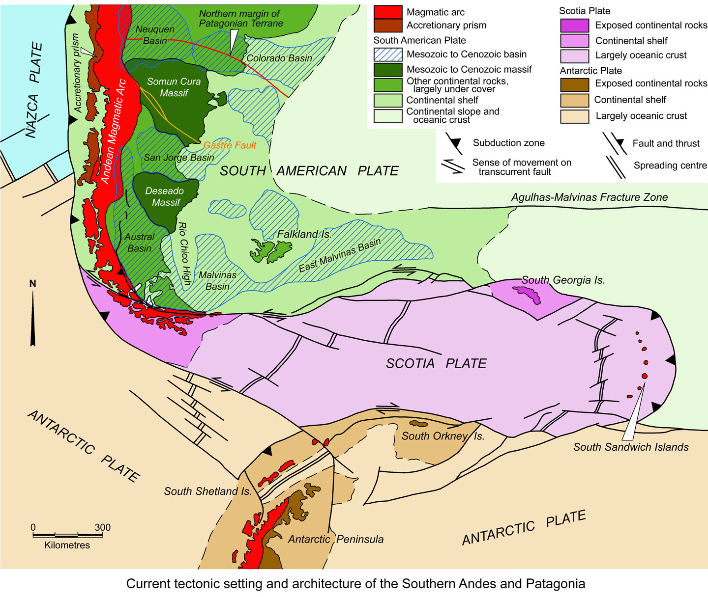
Scotia Plate and fringing islands
The Patagonia Terrane is terminated to the south by a major east-west trending, sinistral transform fault, separating it from the largely oceanic Scotia Plate. This transform splays eastward from the southern Chilean Trench, passing through Tierra del Fuego, to the south of the Malvinas/Falkland Islands and south Georgia. The Scotia Plate is ~600 to 700 km wide, north-south, and ~2000 km long. It is, in turn, separated from the Antarctic Plate to the south by a dextral east-west transform fault passing to the north of the Antarctic Peninsular tip and the South Orkney Islands.
To the east, these two transforms both curve around the eastern extremity of the Scotia Plate to join and form a rounded nose. This advancing nose defines the eastern limit of the Scotia Plate and overrides cold and heavy subducting oceanic crust of the South America Plate with an east vergence. It forms a rounded wedge 'penetrating' the east-west boundary between the oceanic sections of the South American and Antarctic plates. The subduction zone is overlain by the ~390 km long South Sandwich arc, which comprises eleven main islands which are the peaks of stratovolcanoes rising from the ocean floor which is at a depth of ~2600 m. Five of the islands have been volcanically active in the past 100 years (Leat et al., 2013). Individual islands vary from <1 km in diameter to as much as 19 x 20 km (Montagu Island with the 1370 m asl Mt Belinda volcano).
To the west, the southern Chilean Trench curves eastward to form the western margin of the Scotia Plate, separating it from the Antarctic Plate. Over this interval, the north-south subduction zone below the trench becomes a NW-SE sinistral transform that forms the southwestern margin of the Scotia Plate. Both incipient and established spreading centres divide the Scotia Plate into a number of microplates (after Ramos, 2010).
The two 'finger-like' Scotia and Caribbean plates, which define the southern and northern margins of the South American Plate respectively, are somewhat similar in character, other than that the Caribbean Plate represents thick oceanic plateau crust.
Hervé et al. (2008) suggest that prior to the Early Jurassic extensional event, the Antarctic Peninsula formed part of the Gondwana continental margin to the south of the southern Patagonia Terrane. It is composed of a Jurassic to Paleogene volcanic arc, with extensive associated felsic intrusions to the west, and a Mesozoic 'Chon Aike-like' igneous province to the east. These sequences overlie a Palaeozoic metamorphic basement complex, and Palaeozoic to Triassic sedimentary rocks. In turn, they are overlain by and interfinger with Jurassic to Cenozoic sedimentary rocks. As it was rifted and the Antarctic plate drifted south away from South America, the intervening finger-like Scotia Plate was injected from the west, although it is also growing through internal spreading.
The islands fringing the Scotia Plate are either subduction related magmatic arcs (i.e., the South Sandwich arc, and the South Shetland Islands), or are exposed continental crust of the continental shelfs (i.e., the Malvinas or Falkland Islands; South Georgia; South Orkney Islands).
Around 70% of the volcanic rocks of the South Sandwich arc are basaltic, with compositions between mid-ocean ridge basalt (MORB) and tholeiitic basalt. The remainder are andesitic to dacitic, while rhyolite has only been recorded from the northernmost of the chain of volcanoes at Protector Shoal. The andesites and dacites occur on the same islands as the basaltic rocks. Most volcanic rocks are younger than 5 Ma.
The Falkland or Malvinas Islands comprise the main East and West Falkland and a dozen or more subsidiary islands, rocks and reefs that together cover an area of just over 12 000 km2. The oldest rocks are ~1000 Ma granite and gneiss of the Cape Meredith Complex, which occurs as a very limited outcrop on the southern tip of West Falkland. The age is based on 40Ar/39
Ar date of a presumed rhyolitic protolith zircon, and U-Pb dates of ~1090, 1067±9 and 1003±16 Ma from three phases of a granitoid complex that comprises granodiorite orthogneiss, syntectonic granite gneiss and post-tectonic granite respectively (Jacobs et al., 1999). This basement complex is unconformably overlain by a thick (>5000 m) succession of Silurian to Devonian shallow marine quartzites, sandstones and intercalated mudstone. These sequences occupy most of West Falkland and the northern half of East Falkland. They are unconformably overlain by ~850 m of Carboniferous diamictite followed by a thick (>6000 m) succession of sandstones and mudstones that form the southern half of East Falkland. All of these rocks are intruded by both early Jurassic dolerite and Cretaceous basaltic dykes. The Cretaceous to Cenozoic basins that surround the islands contain up to 5000 m of strata (summarised from Stone, 2010).
The ~160 x 5 to 30 km South Georgia Island is dominantly occupied by a the Sandebugten and Cumberland Bay formations, which together comprise up to 8 km of Early Cretaceous sandstones and shales. These sequences are bounded to the south by the WNW to NW trending Cooper Bay Dislocation Zone separating them from a faulted west tapering wedge of older granite and gneiss of the Drygalski Fjord Complex to the east, and a succession of Jurassic basaltic ash, lavas and dykes found to the south and southwest. Half of the island's 3755 km2 is covered with ice and permanent snow from altitudes of 450 to 600 masl on the north coast and 300 masl on the south side, with the highest peak being at 2934 m.
The South Orkney Islands are composed of a basement sequence of marbles, paraamphibolites and quartz-mica schists, the protoliths of which are interpreted to have been limestones, marls, quartzites and mudstones. There is apparently no direct evidence of igneous activity. The age of the sequence is uncertain, possibly Proterozoic to Cambrian, although a K-Ar date of 185 Ma has been attribute to a feeble tectonic overprint. The basement complex is overlain by a possibly Carboniferous greywacke-shale suite, Jurassic sedimentary rocks, intruded by Jurassic dolerite dykes and Cretaceous conglomerates and shales (Thompson, 1968).
Mineralisation
Porphyry Cu deposits
A number of relatively small and/or low grade porphyry Cu deposits and prospects are known within the northern Patagonian Andes. These are largely restricted to the northern transition between the Central and Southern Andes, where erosion has been shallower, and remnants of the Paleogene arc fringing the Patagonian Batholith occur. A small number of uneconomic prospects persist as far south as the central Patagonian Batholith (Zappettini et al., 2008).
The most significant of the small number of porphyry deposits and prospects on the northern extremity of the Patagonian Andes is the Paleogene, ~61 Ma Campana Mahuida deposit, with a resource of 20 Mt @ 0.8% Cu (or 194 Mt @ 0.49% Cu, 0.1 g/t Au), located in the main cordillera in Neuquén, close to the Chilean border (USGS MRDS database). None of the other prospects appear to have estimated resources.
In addition, the Late Carboniferous, 316 to 312 Ma La Voluntad occurrence (Garrido et al., 2008) containing 250 Mt @ 0.15% Cu is located in Neuquén Province of western Argentina, most likely hosted within the western metamorphic-magmatic belt of the Patagonia Terrane, emplaced prior to the development of the Andean Orogen.
Epithermal Gold, Silver and Base Metal Deposits
At least ten significant low-sulphidation gold-silver deposits or clusters and >50 epithermal prospects are distributed over a wide area throughout the Somún Cura and Deseado massifs in Patagonia to the east of the Andes, hosted within the Jurassic rocks of the Marifil and Lonco Trapial formations and Bahía Laura Volcanic Complex (Páez et al., 2010) respectively. These were mostly formed during the Mid Jurassic to Early Cretaceous, from 158 to 130 Ma (Poblete et al., 2014). A number of these deposits are hosted within the Ibáñez Formation at the transition from the Chon Aike igneous province to the Andean magmatic arc, located on the eastern margin of the cordillera, dated between 145 and 124 Ma, whilst other epithermal mineralisation is known nearby in Lower Cretaceous rocks on the eastern flank of the Patagonian Batholith. A number of epithermal Au-Ag prospects and small deposits are also hosted by the Permo-Triassic Choiyoi Group and equivalent Los Menucos Group in the western Somún Cura Massif.
• Deseado Massif - Many of these deposits/clusters are located within the Deseado Massif, the chief of which include the Cerro Vanguardia, Mina Martha, Manantial Espejo, Cerro Moro, Cerro Negro and San José, with a combined production of >150 t of Au and >3000 t of Ag between 2000 and 2015 (Vidal et al., 2016).
• Somún Cura Massif - Similar mineralisation is known within the of the Somún Cura Massif, the most significant of which is the large Navidad Ag-Pb deposit hosted by the Jurassic Cañadón Asfalto Formation (overlying the Lonco Trapial Formation). This individual deposit contains more silver (21 740 t Ag) than all of the rest of the Jurassic deposits of the Chon Aike Large Igneous Province, but no gold. The Calcatreau Au-Ag deposit, ~80 km NW of Navidad, which like Navidad also lies within the Gastre Fault Zone, but is hosted by the Lonco Trapial Formation, has Measured + Indicated resources of 11.40 Mt @ 23.32 g/t Ag, 2.38 g/t Au for 266 t Ag and 27 t Au (Pan American Silver, 2017). Other lesser prospects are found between Calcatreau and Navidad. A number of prospects are also known within the Choiyoi Group equivalent Late Triassic Los Menucos Group in the northwestern part of the Somún Cura Massif. These include the Cerro La Mina, Cerro Abanico and Aguada de Guerra prospects that comprise three large zones of intense alteration of rhyolites, andesites, ignimbrites and tuffs, each of >5 km wide and up to 10 km long that define a 30 km long by 5 to 10 km wide structural corridor. Alteration includes advanced argillic, argillic and silicic assemblages enclosing limited veins of low sulphidation gold mineralisation. The Toruel prospects are located to the SE of the previous and comprise epithermal vein and breccia Ag/Cu/Pb/Zn mineralisation with lesser, although significant gold and indium, hosted within rhyolitic volcanic and tuffaceous sedimentary rocks of the Los Menucos Group. No reserves or resource estimates have been published for any of these prospects (to 2017).
• Andean foothills of eastern Chilean and western Argentine Patagonia, where epithermal mineralisation is hosted within the Jurassic Ibáñez Formation and equivalents. The Cerro Bayo deposit cluster in eastern Chilean Patagonia are hosted within the Jurassic Ibáñez Formation. Other significant deposits that have been delineated, or are past producers, or are being mined, and are hosted by the Ibáñez Formation (or equivalents) includes the El Faldeo Au-Zn-Pb-Ag deposit, 105 km SW of Cerro Bayo, the El Toqui polymetallic Ag-Au deposit (Chile), and the Esquel (Argentina) and Huemules (Argentina) Ag-Au deposits, ~170, ~540 and ~550 km to the north to NNW of Cerro Bayo respectively.
Huemules is located 20 km NW of the town of Esquel in western Chubut, Argentina. It comprises a 3.6 km long vein and stockwork system hosted by Jurassic andesites and microdiorite with grades of <1% Cu-Pb-Zn, 8 to 10 g/t Au and 45 g/t Ag. Reserves were 0.166 Mt of ore containing pyrite, chalcopyrite, galena, sphalerite, anhydrite and gold in a gangue that includes quartz, calcite, gypsum-anhydrite, rhodonite with silica and chlorite. Recent production totalled to 2000 t @ 120 g/t Au between 1989 and 1994.
For more detail, click on the individual deposit/district record links provided above.
The most recent source geological information used to prepare this decription was dated: 2016.
This description is a summary from published sources, the chief of which are listed below.
© Copyright Porter GeoConsultancy Pty Ltd. Unauthorised copying, reproduction, storage or dissemination prohibited.
|
We are endeavouring to ascertain why those pages that display Google Maps cannot now do so correctly, and will remedy as soon as practical.
|
|
|
|
Cawood, P.A., 2005 - Terra Australis Orogen: Rodinia breakup and development of the Pacific and Iapetus margins of Gondwana during the Neoproterozoic and Paleozoic: in Earth Science Reviews v.69, pp. 249-279.
|
Ernst R.E., Liikane D.A., Jowitt S.M., Buchan K.L. and Blanchard, J.A., 2019 - A new plumbing system framework for mantle plume-related continental Large Igneous Provinces and their mafic-ultramafic intrusions: in Journal of Volcanology and Geothermal Research, v.384, pp. 75-84. doi.org/10.1016/j.jvolgeores.2019.07.007.
|
Folguera, A. and Ramos, V.A., 2011 - Repeated eastward shifts of arc magmatism in the Southern Andes: A revision to the long-term pattern of Andean uplift and magmatism: in J. of South American Earth Sciences v.32, pp. 531-546.
|
Paez, G.N., Ruiz, R., Guido, D.M., Jovic, S.M. and Schalamuk, I.B., 2010 - The effects of K-metasomatism in the Bahia Laura Volcanic Complex, Deseado Massif, Argentina: Petrologic and metallogenic consequences: in Chemical Geology, v.273, pp. 300-313.
|
Pankhurst, R.J., Leat, P.T., Sruoga, P., Rapela, C.W., Marquez, M. , Storey, B.C. and Riley, T.R., 1998 - The Chon Aike province of Patagonia and related rocks in West Antarctica: A silicic large igneous province: in Journal of Volcanology and Geothermal Research v.81, pp. 113-136.
|
Poblete, J.A., Bissig, T., Mortensen, J.K., Gabites, J.,Friedman, R. and Rodriguez M., 2014 - The Cerro Bayo District, Chilean Patagonia: Late Jurassic to Cretaceous Magmatism and Protracted History of Epithermal Ag-Au Mineralization: in Econ. Geol. v.109, ppp. 487-502.
|
Ramos, V.A. and Ghiglione, M.C., 2008 - Tectonic Evolution of the Patagonian Andes: in Developments in Quaternary Science, v.11, Ch. 4, pp. 57-71.
|
Ramos, V.A., 2010 - The Grenville-age basement of the Andes: in J. of South American Earth Sciences v.29, pp. 77-91,
|
Ramos, V.A., 2008 - Patagonia: A paleozoic continent adrift?: in J. of South American Earth Sciences v.26, pp. 235-251.
|
Stern, C.R., 2004 - Active Andean volcanism: its geologic and tectonic setting: in Revista Geologica de Chile v.31, pp. 161-206.
|
Thomson, S.N. and Herve, F., 2002 - New time constraints for the age of metamorphism at the ancestral Pacific Gondwana margin of southern Chile (42-52°S): in Revista Geologica de Chile v.29, pp. 151-165.
|
Vidal, C.P., Guido, D.M., Jovic, S.M., Bodnar, R.J., Moncada, D., Melgarejo, J.C., and Hames, W., 2016 - The Marianas-San Marcos vein system: characteristics of a shallow low sulfidation epithermal Au-Ag deposit in the Cerro Negro district, Deseado Massif, Patagonia, Argentina: in Mineralium Deposita v.51, pp. 725-748.
|
|
Porter GeoConsultancy Pty Ltd (PorterGeo) provides access to this database at no charge. It is largely based on scientific papers and reports in the public domain, and was current when the sources consulted were published. While PorterGeo endeavour to ensure the information was accurate at the time of compilation and subsequent updating, PorterGeo, its employees and servants: i). do not warrant, or make any representation regarding the use, or results of the use of the information contained herein as to its correctness, accuracy, currency, or otherwise; and ii). expressly disclaim all liability or responsibility to any person using the information or conclusions contained herein.
|
Top | Search Again | PGC Home | Terms & Conditions
|
|


