|
Luishia, Luisha, Luishia Sud, Kasongwe, Shandwe |
|
|
Katanga, Dem. Rep. Congo |
| Main commodities:
Cu Co
|
|
 |
|
 |
 |
Super Porphyry Cu and Au


|
IOCG Deposits - 70 papers

|
All papers now Open Access.
Available as Full Text for direct download or on request. |
|
 |
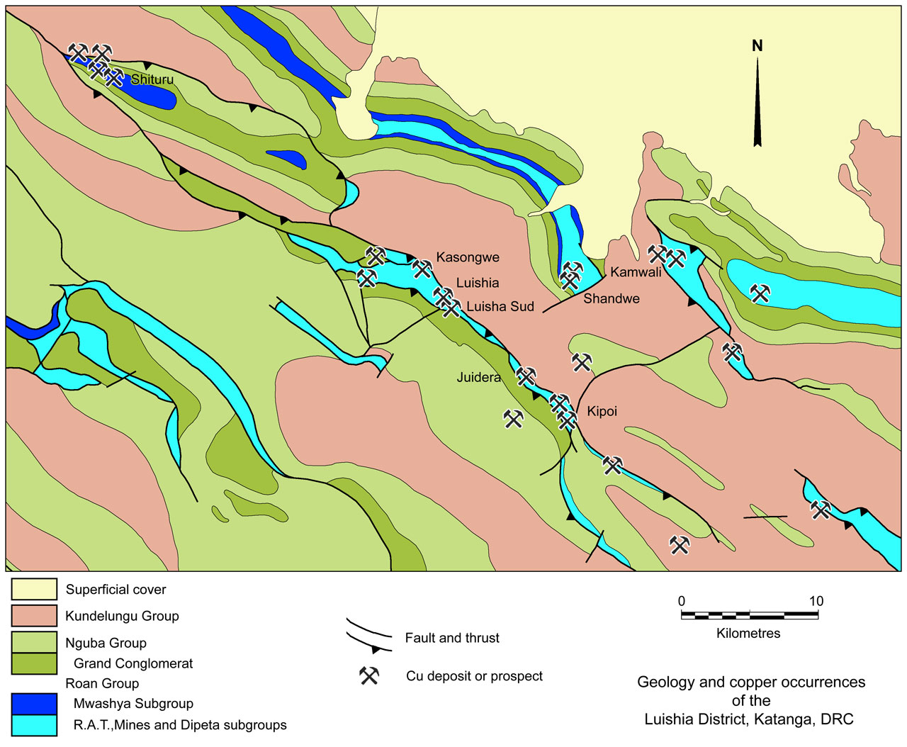
The Luishia (sometimes spelled Luisha) group of sediment hosted copper-cobalt deposits are located in the central Congolese Copperbelt, ~80 km NW of Lubumbashi and ~38 km SE of Likasi in the Katanga Province of southern Democratic Republic of Congo (#Location: 11° 10' 19"S, 27° 0' 32"E)
Other smaller deposits that have been historically mined and treated at Luishia include Luishia Sud, Kasongwe and Shandwe to the SE, NW and east respectively.
Regional Setting
For details of the regional setting and stratigraphy see the separate Central African Copperbelt - Congolese/Katangan Copperbelt record.
The Luishia deposits are situated along the NW-SE trending Luishia thrust slice/nappe/antiform ("Le chevauchement de Luishia"), which is a structural extension of the Kambove nappe 50 km to the NW, via the Likasi-Shituru district, and is also connected by a thrust along trend to the SE with the Luiswishi-Etoile antiform.
In the Luishia district, this structure comprises a core of disrupted Roan Group megabreccia rocks, overthrust onto younger Kundelungu Group rocks to the NE, and overlain to the SW, either structurally or stratigraphically, by the Nguba Group sequence, usually the Grand Conglomerat Formation.
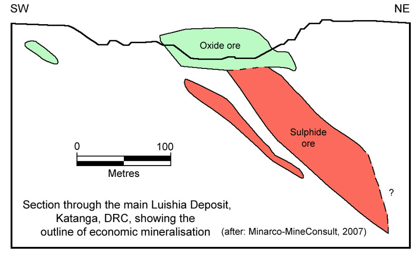
Mineralised Mines Subgroup rocks of the Roan Group occur as a number of dislocated mega-fragments (or écailles) within the megabreccia. To the south, at Luishia Sud, the sequence within the mineralised écaille dips at 45 to 60° to the SW, whereas, <500 m to the NNW in the fragment that hosts the ore in the main Luisha SE pit, the sequence dips and faces 50 to 60° to the NE. The Mines Subgroup appears to be concordantly overlain by Mwashya Series, which form the main relief at Luishia.
Geology
At Luishi, the host Mines Subgroup is only poorly exposed, covered by a layer of red soil, which varies from <5 m, averaging ~10 m in thickness, although it locally reaches 30 m, and is underlain by a leached zone. The individual mineralised mega-fragments are surrounded by fault and R.A.T. breccias to the NE, and to the NW and SE separating fragments at both Luishia and Luishia Sud. According to François (1974), the host sequence in Luishia mine comprises, from the base:
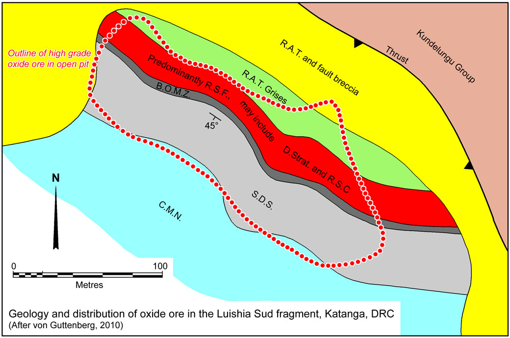
• Roches Argilo Talqueuses (R.A.T.), most likely the R.A.T. Grises (Grey R.A.T., R-2.1.1) - at Luishia Sud, this unit is exposed in the weathered zone as an ~1 m thick silicified vuggy carbonate horizon, where it overlies up to 20 m of thin platy-weathering calcareous siltstones on the northeastern wall of the pit. It locally carries high-grade Cu-Co mineralisation in the oxide zone.
• Dolomites Stratifées (D.Strat., R-2.1.2a) - well bedded argillaceous dolostone; and Roches Siliceuses Feuilletées (R.S.F., R-2.1.2b) - laminated siliceous dolostone. These units are not generally differentiated, particularly at Luishia Sud, where they are represented in the weathered zone by ~25 m of what is described as "a softer, bedded calcareous siltstone" by von Guttenberg (2010).
• Roches Siliceuses Cellulaires (R.S.C., R-2.1.3) - massive siliceous dolostone, which is only poorly developed or locally absent at Luishia.
• Dolomitic Shale Formation, (S.D., R-2.2) - which is subdivided into,
- Schistes Dolomitiques de Base, (S.D.B. or S.D.-1a, R-2.2.1a) - bedded grey shale and sandy dolostone,
- Black Ore Mineralised Zone, (B.O.M.Z. or S.D.-1b, R-2.2.1b) - a narrow band of dark, stratified dolostone,
- Schistes Dolomitiques Supérieur (S.D.S.) - further subdivided into, R-2.2.2, a stratified dolostone and R-2.2.3, composed of alternating grey shale and sandy dolostone.
At Luishia Sud, the S.D. Formation is represented by ~30 m of what is described by von Guttenberg (2010) as a weathered more competent calcareous siltstone.
• Calcaire á Mineral Noir, or C.M.N., R-2.3 - stratified dolostone. At Luishia Sud, the C.M.N is represented by >50 m of weathered massive limestone (von Guttenberg, 2010).

Mineralisation

High grade mineralisation is present in the R.S.F, B.O.M.Z., and S.D. and at the contact between the S.D. and the C.M.N., with a combined true thickness of ~60 m at Luishia Sud (Montgomery, 2011), and varies from <50 to 80 m thick at Luishia, although copper mineralisation is known over a true thickness of ~180 m (Minarco Mineconsult 2007).
At Luishia, mineralisation has historically been worked in two ~300 m long pits at the NNW and SSE extremities of a 1.3 km interval. According to Minarco Mineconsult (2007), mineralisation at Luishia occurs over a strike length of ~2 km, in one major and six lesser separate lenses, with the copper and cobalt not always coincident, predominantly hosted in fractured, brecciated and silicified dolostones.
The Luishia Sud deposit is hosted by a 300 km long fragment of Mines Subgroup rocks, enclosed on three sides, as described above, by R.A.T. and fault breccia. High grade, >5% Cu mineralisation occurs over a 200 m length of the fragment, terminated by the breccia zone to the NNW and decreasing in grade towards the similar breccia to the SSE.
Oxide zone mineralisation begins just below the red soil cover, separated by a narrow leached zone, and comprises malachite, pseudomalachite, chrysocolla cuprite and native copper, occurring as thin coatings on fractures and bedding planes, but locally forming centimetre-thick layers. Cobalt mineralisation occurs as dark grey to black heterogenite, frequently with a sandy or powdery texture. The limit of the oxide zone at Luishia Sud is at 32 metres depth (von Guttenberg, 2010).
Below the base of oxidation, the oxide assemblage gives way to the sulphides chalcopyrite, bornite and chalcocite with grades of <5% Cu (von Guttenberg, 2010).

Reserves, Resources and Production
Published figures vary, and include:
Luishia district deposits production, 1913 to 1939 (Union Miniere, 1940, quoted by Montgomery, 2011)
4.073 Mt @ 8.33% Cu,
Luishia district deposits reserves, January 1940 (Union Miniere, 1940, quoted by Montgomery, 2011)
Luishia - 1.083 Mt @ 11.30% Cu,
Luishia Sud - 0.203 Mt @ 10.10% Cu,
Kasongwe - 0.170 Mt @ 7.20% Cu,
Shandwe - 0.209 Mt @ 8.60% Cu,
TOTAL 1.844 Mt @ 10.12% Cu,
Luishia-Kasongwe group of deposits, production + 'reserves' (Hitzman et al., 2012, after Woodhead, unpub. 2012),
62.9 Mt @ 2.82% Cu, 0.09% Co.
Luisha deposit - 49.4 Mt @ 3.16% Cu, 0.401% Co (Zientek, et al., USGS, 2014).
Main Luisha deposit of CIMC (Minarco Mineconsult, 2007), remaining resources,
No I orebody, indicated resource - 21.931 Mt @ 2.94% Cu, 0.68% Cu,
inferred resource - 2.754 Mt @ 3.23% Cu,
No II orebody inferred resource - 0.452 Mt @ 1.6% Cu,
No III-1 orebody inferred resource - 0.366 Mt @ 2.15% Cu,
No III-2 orebody inferred resource - 0.160 Mt @ 2.74% Cu,
No III-3 orebody inferred resource - 0.072 Mt @ 2.59% Cu,
No IV orebody inferred resource - 0.265 Mt @ 4.35% Cu,
No V orebody inferred resource - 0.147 Mt @ 3.53% Cu,
TOTAL indicated + inferred resource - 26.147 Mt @ 2.95% Cu, 21.931 Mt of which also carries 0.68% Co.
Luisha Sud deposit, at a 0.75% Cu cutoff in 2011 (Montgomery, 2011), were
inferred resource - 0.240 Mt @ 1.4% Cu, 0.5% Co.
Sources of information include:
"François, A., 1974 - Stratigraphie, tectonique et minéralisations dans l'Arc cuprifére du Shaba (Rép.du Zaïre), in Bartholomé, P., (Ed.), Gisements stratiformes et provinces cupriféres: Liège, Centenaire de la Société Géologique de Belgique, pp. 79-101";
"Minarco-MineConsult, 2007 - Independent Technical Review prepared for China Railway Group Limited, 48p.";
"von Guttenberg, R., 2010 - Technical report, Luisha copper-cobalt project, Katanga Province, Democratic Republic of the Congo, N43-101 prepared for African Metals Corporation by Strathcona Mineral Services Limited, 70p.";
"Montgomery, M., 2011 - Independent Resource Report on Luisha South Low Grade Stockpile, Luisha South Prospect, Luisha Copper Project, Katanga Province, Democratic Republic of Congo, Prepared for African Metals Corporation by Geosure Exploration & Mining Solutions Pty Ltd., 89p.".
The most recent source geological information used to prepare this decription was dated: 2011.
Record last updated: 3/1/2016
This description is a summary from published sources, the chief of which are listed below.
© Copyright Porter GeoConsultancy Pty Ltd. Unauthorised copying, reproduction, storage or dissemination prohibited.
Luishia
|
|
|
|
Porter GeoConsultancy Pty Ltd (PorterGeo) provides access to this database at no charge. It is largely based on scientific papers and reports in the public domain, and was current when the sources consulted were published. While PorterGeo endeavour to ensure the information was accurate at the time of compilation and subsequent updating, PorterGeo, its employees and servants: i). do not warrant, or make any representation regarding the use, or results of the use of the information contained herein as to its correctness, accuracy, currency, or otherwise; and ii). expressly disclaim all liability or responsibility to any person using the information or conclusions contained herein.
|
Top | Search Again | PGC Home | Terms & Conditions
|
|