|
Kakanda, Mukondo, Kabankola, Kimbasalania, Kamikunda, Kawewa, Bangwe, Disele Sud |
|
|
Katanga, Dem. Rep. Congo |
| Main commodities:
Cu Co
|
|
 |
|
|
 |
Super Porphyry Cu and Au


|
IOCG Deposits - 70 papers
|
All papers now Open Access.
Available as Full Text for direct download or on request. |
|
|
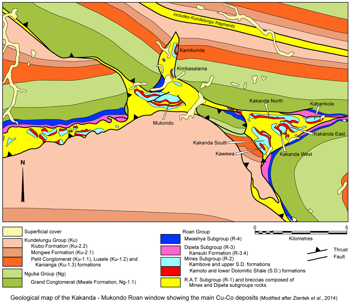
The Kakanda-Mukondo group of sediment hosted copper-cobalt deposits are located in the central Congolese Copperbelt, ~100 km east of Kolwezi, and ~160 km NW of Lubumbashi in the Katanga Province of southern Democratic Republic of Congo (#Location: Kakanda South - 10° 44' 21"S, 26° 23' 40"E; Mukondo - 10° 43' 29"S, 26° 21' 8"E)
These deposits occur within a structural window of Roan Group megabreccia that is elongated WNW-ESE over an ~10 km x 1 to 5 km area and includes the Kakanda cluster of Kakanda North, South, East and West, Kabankola and Kawewa in the eastern half of the window, and Mukondo and the smaller Kimbasalania and Kamikiunda deposits in the western half. A narrower, 500 to 1500 m wide corridor of Roan mega-breccia extends to the WSW for a further 15 km from the Mukondo section of the window, north of a south-vergent thrust, hosting deposits such as Luita, Disele and Lufumboshi.
Geological Setting
The Roan megabreccia in the Kakanda-Mukondo Roan window comprises a series of jostled fragments and mega-fragments of Roan Group rocks up to 2.5 km long and up to 500 m thick, set within a matrix of rock flour to boulder sized material of the same lithologies.
For details of the regional setting and stratigraphy see the separate Central African Copperbelt - Congolese/Katangan Copperbelt record.
The Roan Group in the district comprises the following, from the base:
R.A.T. (Roches Argilleuses Talceuse) Subgroup (R-1) - normally composed of red to lilac silty, sandy, dolomitic rocks, which are generally quite massive but show evidence of shearing in places. In outcrop, they form deeply weathered, strongly leached sandy masses. Two types of breccia occur within this mass:
• Breche R.A.T. - a reddish-pink brecciated rock with calcite and silica veinlets, at times well mineralised with veinlets of specular hematite. This breccia has been interpreted to be of a hydraulic origin, soley composed of homogeneous R.A.T. fragments.
• Breche Heterogene - the lowermost 'unit' encountered in the area, containing fragments of all the various lithologies of the Roan Group. These fragments are generally angular, sometimes well rounded, but are always highly mixed populations. Fragments range from a few millimetres to several centimetres in diameter. The matrix is composed of finer-grained sandy particles of the same material as the fragments.
Mines Subgroup (R-1) - comprising the following:
Kamoto Formation, R-2.1, subdivided into,
• R.A.T. Grises - a grey to green reduced upper section of the R.A.T., R-1, that is sometimes mineralised and is considered part of the Mines Subgroup package. At Kakanda, this unit is 2 to 5 m thick and comprises a grey-green dolomitic siltstone, carrying malachite and black oxides ('oxide noir') in the weathered zone.
• Dolomie Stratifées (D.Strat.) - a stratified dolomite, which When well developed, is a well bedded to laminated, silty and sandy (argillaceous) dolomite, and is generally ~3 m thick at Kakanda. It has a transitional upper contact with the overlying R.S.F., and in some cases the two rock units are difficult to distinguish. In the weathered zone, mineralisation occurs as copper and cobalt oxides, as well as black oxides and forms part of the traditional 'Lower Ore Zone'.
• Roches Siliceuses Feuilletées (R.S.F.) - comprising characteristic, thinly bedded to laminated, highly silicified dolomitic rocks, which are ~5 m thick at Kakanda. They vary from grey to light brown silicified dolomite with white silica bands. Like the D.Strat., they are generally well mineralised with copper and cobalt oxides in the weathered zone, and forms the remainder of the 'Lower Ore Zone'.
• Roches Silicieuses Cellulaires (R.S.C.) - grey silicified cellular, massive to stromatolitic dolostones, normally carrying considerable amounts of black oxides in the weathered zone, occurring as dark to black, very powdery fillings in open vugs. Locally these fillings are more brownish coloured and seem to be rich in iron oxides and are frequently leached. However, below the base of supergene mineralisation, it largely represents a barren portion of the succession. It usually forms bare conspicuous ridges, acting as indicator horizons, and at Kakanda is 10 to 25 m thick.
Dolomitic Shale Formation, (S.D.) - divided into,
• Schistes de Base, (S.D.B.) - normally a ~10 m thick reddish-brown to grey, silty dolostone to siltstone containing locally isolated thin layers of nodules and individual nodules. The nodules are composed of coarser grains and fragments of dolomite and are normally weathered out to form small cavities. Locally, they are replaced by more or less shaly dolostones. The S.D.B.is one of the main ore bearing horizons, hosting the bulk of the Upper Orebody, which contains copper and cobalt in varying amounts.
• Shales Dolomitiques Superieur, (S.D.S.) - composed of up to 85 m of dolomitic siltstone and fine-grained sandstone, sometimes containing thin beds of grey dolostone. In weathered sections, the dolomitic siltstones are sandy and crumble easily, and vary from yellow to cream and red. They are dominantly bedded and laminated, and are normally not mineralised, with only isolated malachite traces in the oxide zone.
Kambove Formation, or Calcaire á Mineral Noir (C.M.N.) - normally a sequence of light grey to grey, predominantly massive to weakly banded and laminated silty to sandy dolostones with occasional silicified bands. In places, the dolostones are strongly silicified and cellular, somewhat similar in appearance to the RSC dolostones. In the oxide zone they carry
some black oxides of iron, manganese and cobalt. It is locally split into,
• Lower Kambove Member, or C.M.N. Inferior, composed of ~85 m of massive stromatolitic dolostone,
• Upper Kambove Member, or C.M.N. Superieur, comprising ~40 m of talcose dolostone and siltstone.
Dipeta Subgroup (R-3) - commences with the Roches Greseuse Superieur (R.G.S.), which consists of dolomitic shales and sandy schists with silicified dolomitic beds towards the top. It unconformably overlies the C.M.N.and marks the base of the subgroup. The remainder of the subgroup, which can be up to 1000 m thick, consists of shales and sandy schists with intercalated dolostones and
limestones. Sporadic copper mineralisation is not uncommon.
Mwashya Subgroup (R-4) - the uppermost unit of the Roan Group, which overlies the Dipeta Subgroup, and consists of two layered sequences, R-4.1 and R-4.2, each composed of shales, siltstones, sandstones and dolostones with jasper, siliceous beds and chert. These two sequences together can be up to 100m thick and commonly contain copper mineralisation.
Mineralisation
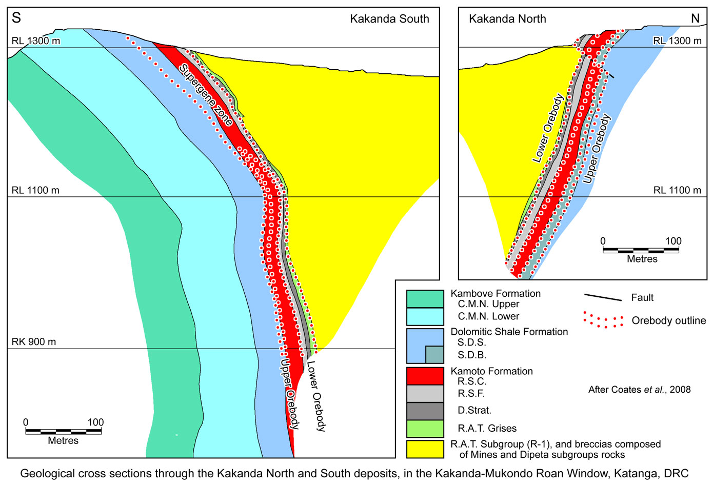
Hypogene mineralisation primarily occurs in two layers, the 'Lower' and 'Upper' orebodies. The two layers are separated by barren or patchily mineralised siliceous dolostone of the R.S.C., which varies from massive to bedded and commonly stromatolitic varieties, with some minor mineralised argillaceous horizons, and is usually mined as internal waste.
The Lower Orebody is the most extensively mineralised, although the Upper is usually higher grade. The former occurs within three units, the dolomitic and chloritic sandstones of the R.A.T. Grises (locally underlain by a footwall conglomerate), the siliceous dolostone and dolomitic shale of the D.Strat., and the laminated siliceous dolostones of the R.S.F.
The Upper Orebody is hosted within dolomitic shale or argillite of the Dolomitic Shale (S.D.) Formation, the lower 10 m of which usually constitutes ore, mostly in intercalated shale beds.
Within the Kakanda-Mukondo Roan window, mineralisation within these two orebodies is all hosted within a series of mega-fragments (écailles) of Mines Subgroup rocks of the Roan megabreccia. Details of the individual deposits includes,
Kakanda North, extends for ~1100 m in an east-west elongated écailles along the flanks of, and towards the crest of a treeless ridge. The host sequence is is overturned, with an average dip at surface of 60°S, tending to near vertical with depth. The two orebodies are structurally relaively simpe and unfaulted, hosted by a regular sequence that ranges from C.M.N.in the north to R.A.T. Grises in the south.
Stratigraphically ~200 to 300 m to the north of the ore body, the C.M.N. is in structural contact with the
Grand Conglomérat of the Nguba Group, separated by R.A.T. breccias. The Mines Subgroup sequence can be traced eastward from the ore deposit for another ~1 km without visible surface mineralisation.
Mineralisation is principally within the Lower Orebody, although a band of ore hosted by the Dolomitic Shale (S.D.) Formation is equally well mineralised. Mineralisation in the R.S.C. is poor and irregular. In the oxide zone, mineralisation is almost entirely of malachite, with some copper silicate near the surface. The ore is partly oxidised to depth, where drill holes recovered malachite and chalcocite, with very small amounts of bornite and chalcopyrite.
Kakanda South, occurs within a 1400 m long écaille composed of a 40 to 60°NE dipping, overturned Mines Subgroup sequence that extends NE-SW along the flank of a ridge. The sequence ranges from R.A.T. Grises in the NE, to C.M.N. in the SW. Several minor faults disclocate the deposit, particularly in the central parts where two masses of R.A.T. intrude the stratigraphy. The ore body is limited in all directions by breccias, including to the SW where the top of the preserved C.M.N.is bounded by breccia.
The mineralisation of the Lower Orebody is principally hosted within the R.A.T. Grises and R.S.F., while the Upper Orebody is within the lower Dolomitic Shale Formation and adjacent R.S.C.. Tested mineralisation is almost entirely from the oxide ore above the water table, where it is composed of malachite, with some copper silicate, before passing to suphide ore at depth.
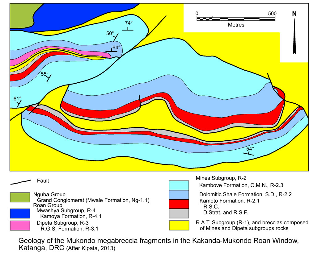 Mukondo, is located near the crest of a steep ridge that forms Mukondo Mountain. It comprises two east-west trending mega-fragments/écailles of Mines Subgroup rocks dipping to the north with a normal stratigraphic superposition. The eastern fragment is folded into a south-vergent, R.A.T. breccia-cored anticline (Kipata, 2013).
The northwestern and southeastern écailles are 1.4 and 1.8 km long respectively (François, 2006). They are offset across a NE trending fault occupied by a breccia made up of elements of both grey argillaceous dolomitic siltstone (R.A.T. Grises) and stromatolitic laminated talcose C.M.N. dolostone. The western segment of the deposit terminates against a monomictic breccia of R.A.T. Grises (Kipata, 2013).
Stratabound malachite is developed in the Dolomitic Shale (S.D.) Formation rocks, whilst coatings of Cu minerals are found in fractures, cavities and veins in both the S.D. Formation and stromatolitic dolostone of the R.S.C. The breccia bounding the northwestern écaille and that separating it from the southeast fragment are also mineralised in the oxide zone. To the west of the deposit, the contact between the R.S.C. and R.S.F. units is fractured to form a non-cemented breccia with abundant black Cu and Co oxides (Kipata, 2013).
Disele Sud, which is ~10 km to the WSW of Mukondo, is hosted by one of a string of Mines Subgroup écailles that are randomly distributed along the arm of the Kakanda-Mukondo Roan window that extends in that direction. Luita East and Sud are located halfway between Mukondo and Disele Sud, while Lufumboshi is a further 4 km to the west of the latter.
Production and resources
Published figures include:
Historic production, Kakanda pits - no reliable figures are available, although the tailings suggest the magnitude of the tonnage removed.
Tailings resource - 18.5 Mt @ 1.2% Cu Total, and 0.15% Co Total, (Coates et al., 2008).
Kakanda North (Non-NI 43-101 compliant; Coates et al.< 2008),
Inferred resource at 1% Cu cut-off - 23.287 Mt @ 2.62% Cu Total, 1.79% Cu Oxide, 0.17% Co Total, 0.08% Co Oxide.
Inferred resource at 2% Cu cut-off - 13.648 Mt @ 3.35% Cu Total.
Kakanda South (Non-NI 43-101 compliant; Coates et al., 2008),
Inferred resource at 1% Cu cut-off - 8.774 Mt @ 2.21% Cu Total, 1.26% Cu Oxide, 0.18% Co Total, 0.05% Co Oxide.
Inferred resource at 2% Cu cut-off - 4.950 Mt @ 2.76% Cu Total.
TOTAL Kakanda North and South pits (Non-NI 43-101 compliant; Coates et al., 2008),
Inferred resource at 1% Cu cut-off - 32.061 Mt @ 2.51% Cu Total, 1.64% Cu Oxide, 0.17% Co Total, 0.07% Co Oxide.
Inferred resource at 2% Cu cut-off - 18.598 Mt @ 3.19% Cu Total.
Kabankola (or Kababankola) (Central African Mining and Exploration Company, 2008),
Non-JORC compliant resources - 1.887 Mt @ 1.62% Cu, 1.12% Co.
Kakanda East (Central African Mining and Exploration Company, 2008),
Non-JORC compliant resources - 0.166 Mt @ 4.03% Cu, 0.46% Co.
Kakanda West (Central African Mining and Exploration Company, 2008),
Non-JORC compliant resources - 0.1113 Mt @ 2.86% Cu, 0.13% Co.
Bangwe East (1250 m west of Kakanda North; Central African Mining and Exploration Company, 2008),
Non-JORC compliant resources - 0.240 Mt @ 4.3% Cu.
Kakanda group of deposits (Coates et al., 2008 and Woodhead, J., unpub.data, 2012),
Production + resources - 41.3 Mt @ 3.13% Cu, 0.14% Co.
Mukondo Mountain (Central African Mining and Exploration Company, 2008),
Non-JORC compliant resources - 36.256 Mt @ 2% Cu, 1.4% Co.
Luita East and Sud (~5 km SW of Mukondo; Central African Mining and Exploration Company, 2008),
Non-JORC compliant resources - 0.374 Mt @ 3.0% Cu, 0.60% Co.
Disele Sud (~10 km WSW of Mukondo; Central African Mining and Exploration Company, 2008),
Non-JORC compliant resources - 2.63 Mt @ 3.01% Cu, 0.05% Co.
Lufumboshi (~4 km west of Disele Sud; Central African Mining and Exploration Company, 2008),
Non-JORC compliant resources - 0.225 Mt @ 1.98% Cu, 0.06% Co.
TOTAL Kakanda and Mukondo district (Central African Mining and Exploration Company, 2008),
Non-JORC compliant resources (including Kakanda Tailings) - 75.60 Mt @ 2.73% Cu, 0.42% Co.
In their annual report, 2012, ENRC which acquired the Central African Mining and Exploration Company quoted the following open pit Measured + Indicated + Inferred Mineral Resources as at December, 2012:
Kakanda 94.4 Mt @ 2.3% Cu, 0.1% Co;
Mukondo Mountain 4.3 Mt @ 1.3% Cu, 1.3% Co;
Kavundi Central 2.4 Mt @ 1.4% Cu, 0.0% Co;
Taratara 4.3 Mt @ 1.3% Cu, 0.6% Co;
Saafi 1.1 Mt @ 2.5% Cu, 0.4% Co;
Chimbedia 1.2 Mt @ 1.9% Cu, 0.2% Co;
Kababankola 4.8 Mt @ 1.3% Cu, 0.7% Co;
Disele Sud 5.8 Mt @ 1.8% Cu, 0.0% Co;
Luita Est (Ecaille Sud) 2.3 Mt @ 2.0% Cu, 0.4% Co;
Bangwe Est 0.9 Mt @ 2.0% Cu, 0.1% Co;
TOTAL for Kakanda district 120.8 Mt @ 2.2% Cu, 0.2% Co;.\
This summary is largely drawn from: "Coates, H., Anderson, W. and McGeorge, I., 2008 - Technical report on the Kakanda copper-cobalt project, Katanga Province, Democratic Republic of Congo; Prepared for Simberi Mining Corporation by MPH Consulting Limited, 176p.", and
"Kipata, M.L., 2013 - Brittle tectonics in the Lufilian fold and thrust belt and its foreland - An insight into the stress field record in relation to moving plates (Katanga, DRC); Doctor of Science, Geology dissertation, Katholieke Universiteit Leuven, Heverlee, Belgie, 182p."
The most recent source geological information used to prepare this decription was dated: 2013.
Record last updated: 14/1/2016
This description is a summary from published sources, the chief of which are listed below.
© Copyright Porter GeoConsultancy Pty Ltd. Unauthorised copying, reproduction, storage or dissemination prohibited.
Kakanda South Mukondo
|
|
|
|
Porter GeoConsultancy Pty Ltd (PorterGeo) provides access to this database at no charge. It is largely based on scientific papers and reports in the public domain, and was current when the sources consulted were published. While PorterGeo endeavour to ensure the information was accurate at the time of compilation and subsequent updating, PorterGeo, its employees and servants: i). do not warrant, or make any representation regarding the use, or results of the use of the information contained herein as to its correctness, accuracy, currency, or otherwise; and ii). expressly disclaim all liability or responsibility to any person using the information or conclusions contained herein.
|
Top | Search Again | PGC Home | Terms & Conditions
|
|


