|
Fosterville |
|
|
Victoria, Vic, Australia |
| Main commodities:
Au
|
|
 |
|
|
 |
Super Porphyry Cu and Au


|
IOCG Deposits - 70 papers
|
All papers now Open Access.
Available as Full Text for direct download or on request. |
|
|
The Fosterville gold deposit is located 20 km to the ENE of Bendigo in north-central Victoria and 130 km NNW of Melbourne. It lies within the Bendigo Zone of the Palaeozoic Lachlan Orogen and comprises fault controlled deposits developed along and adjacent to a series of major, sub-parallel, steeply dipping mineralised structures developed as shoots over intervals of up to 10 km (#Location: 36° 43' 0"S, 144° 30' 12"E).
Gold was first discovered in the Fosterville area in 1894 with mining activity continuing until 1903 for a total production of 0.87 t of gold. Apart from a minor tailings retreatment in the 1930's, activity resumed in 1988 with a further tailings retreatment program conducted by Bendigo Gold Associates which ceased in 1989. Mining was recommenced in 1991 by Brunswick Mining NL and then Perseverance Corporation Ltd (from 1992) after a systematic reverse circulation drilling program along the two main gold trends, Fosterville and O'Dwyers that are ~1500 m apart, to indicate sufficient resources of heap leach oxide ore. commenced heap leaching operations from shallow oxide open pits. Some 21 shallow pits were developed to depths of 35 to 60 m over a strike length of 10 km. Between 1988 and the cessation of oxide mining in 2001, a total of 7.46 t of gold were poured (Roberts et al., 2003). Towards the end of oxide mining, an underlying sulphide resource was recognised and tested. Perseverance completed a feasibility study into a sulphide mining operation which was completed in 2003, with construction and open pit mining commencing in early 2004. Commercial production commenced in April 2005. In February 2008, Perseverance was acquired by Northgate Minerals Corporation. In August 2011, Northgate entered into a merger agreement with AuRico Gold Inc., who assumed control of Northgate in October 2011. In March 2012 AuRico and Crocodile Gold Corp. jointly announced that Crocodile Gold would acquire the Fosterville and Stawell Mines. Crocodile Gold's ownership of Fosterville was completed on May 4, 2012. In early July 2015, Newmarket Gold Inc. merged with Crocodile Gold to form Newmarket Gold Inc. (Newmarket Gold, 2016). In November 2016, Kirkland Lake Gold Inc. of Canada merged with Newmarket to form Kirkland Lake Gold Ltd. which then increased the output at Fosterville based on its exploration success, in particular, the development of the high grade Eagle and Swan mineralised zones. By the end of 2018, the sulphide plant had produced over 55 t of Au since its commissioning in 2005.
Regional Setting
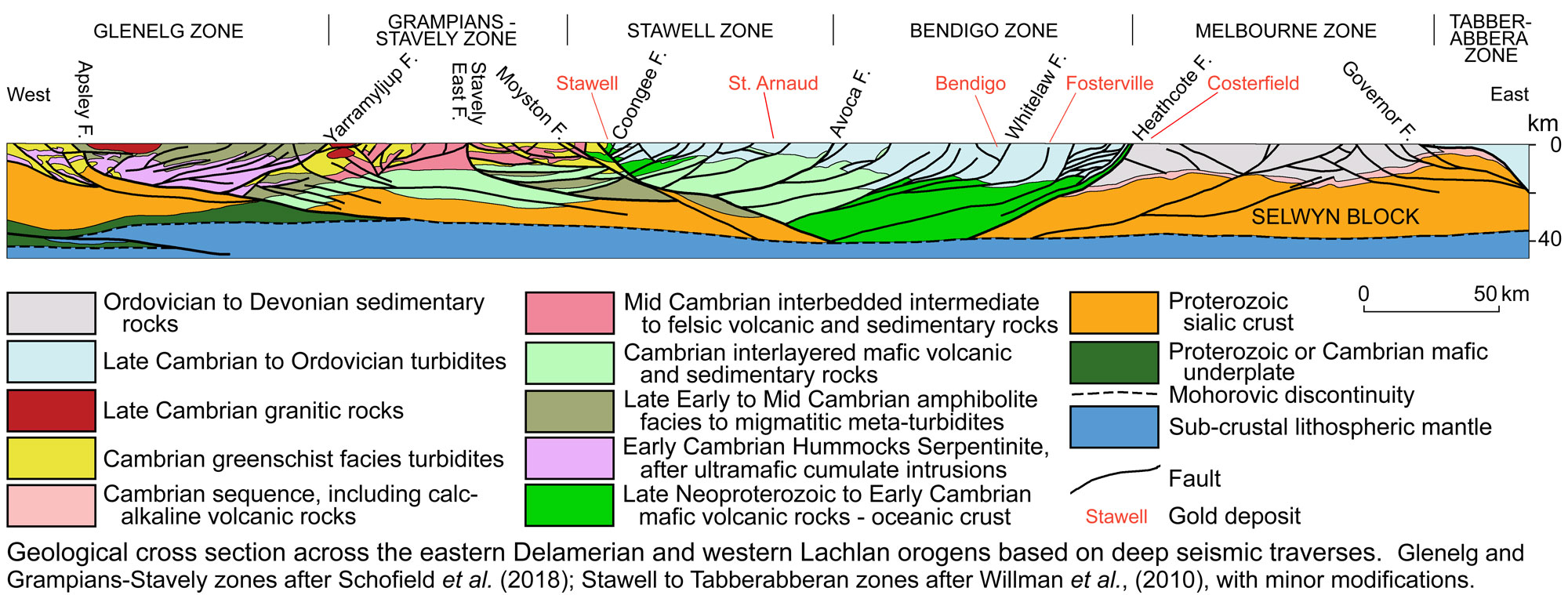
The Fosterville Goldfield is located in the Bendigo Zone of the Lachlan Orogen, within a host sequence dominated by folded and faulted Ordovician (Lancefieldian 488 to 486 Ma) turbidites of the Castlemaine Group which were subsequently deformed in the Late Ordovician (450 to 430 Ma) Benambran and Late Devonian Tabberabberan orogenies. Deformation of the sediment pile during these events was under east-west compression which produced a fold and thrust belt within the Bendigo Zone with north-south folds dislocated by a series of steep, deep west-dipping reverse faults which progressively flattened down dip. These deep structures are interpreted to have been the likely conduits for ascending mineralised fluids. They include the major north-south to NNE-SSW Redesdale Fault, which is 1 to 3 km to the east of Fosterville, obliquely converging southward with the mineralised structures at Fosterville.
Three broad periods of gold mineralisation have been delineated across the western Lachlan Orogen by radiogenic dating. The first of these was from 455 to 440 Ma during the Benambran Orogeny in the Upper Ordovician to Early Silurian, whilst the second was from 420 to 410 Ma in the latest Silurian to Early Devonian, coeval with the Bindian Orogeny. These are associated with quartz vein hosted mineralisation extending across Victoria from Stawell in the west through Bendigo to Wattle Gully in the east, spanning the Stawell, Bendigo and Melbourne zones. 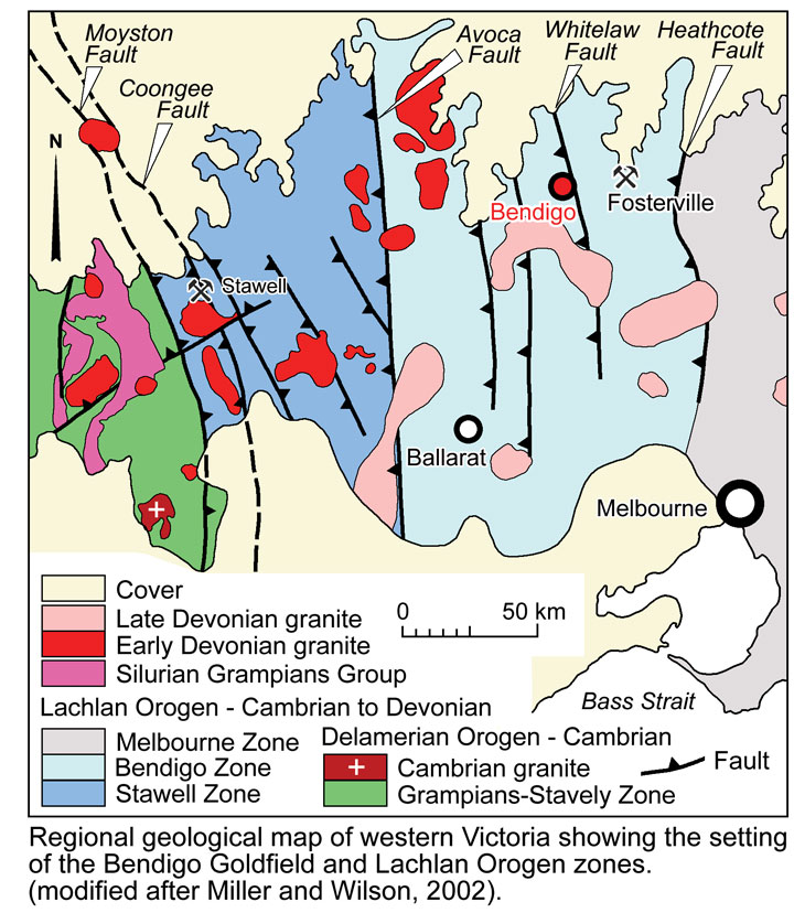 Two granitic suites, and related felsic dykes, were intruded into the Bendigo Zone, the first during the early Devonian and the second in the late Devonian. The closest examples outcrop 16 km east and 30 km south of Fosterville. The second of these intrusive suites appears to be linked to the third phase of mineralisation between 380 and 365 Ma, and corresponds to the Late Devonian Tabberabberan Orogeny. The mineralisation at Fosterville appears to have formed during this third phase, as does that at Costerfield and the Walhalla to Woods Point trend, both in the neighbouring Melbourne Zone. The mineralisation during this event varies from quartz-carbonate vein-hosted free gold to arsenopyrite-pyrite hosted refractory gold (e.g., Fosterville) and stibnite with visible gold (e.g., Fosterville and Costerfield). Two granitic suites, and related felsic dykes, were intruded into the Bendigo Zone, the first during the early Devonian and the second in the late Devonian. The closest examples outcrop 16 km east and 30 km south of Fosterville. The second of these intrusive suites appears to be linked to the third phase of mineralisation between 380 and 365 Ma, and corresponds to the Late Devonian Tabberabberan Orogeny. The mineralisation at Fosterville appears to have formed during this third phase, as does that at Costerfield and the Walhalla to Woods Point trend, both in the neighbouring Melbourne Zone. The mineralisation during this event varies from quartz-carbonate vein-hosted free gold to arsenopyrite-pyrite hosted refractory gold (e.g., Fosterville) and stibnite with visible gold (e.g., Fosterville and Costerfield).
Late Silurian to Early Devonian felsic dykes up to 10 m thick have intruded faults in parts of the deposit area (Arne et al., 1998), predominantly along anticlinal axial planes (King, 2005; Reed, 2007) and postdate all significant faulting. Middle Jurassic (157 to 153 Ma; Bierleinet al., 2001) lamprophyre dykes that are typically <1 m thick, intrude along faults of the general Fosterville Fault trend and post-date all significant faulting and mineralisation. Neogene erosion, was followed by deposition of the Cenozoic Murray Basin and back filling of river valleys with local clay conglomerate. This erosion resulted in complete oxidation to ~30 to 40 m below surface. This zone is immediately underlain by a 10 to 15 m thick interval of partial oxidation of sulphide minerals. The upper section of a zone of feldspar destruction and partial carbonate dissolution to a depth of ~150 m below the surface. Miocene basalt flows of the Newer Volcanic Group mask both the Ordovician rocks and Murray Basin Sediments ~2 km to the east of Fosterville.
Geology and Structure
The deposits of the Fosterville Goldfield are hosted by a turbiditic sequence of interbedded sandstones, siltstones and shales interpreted to have formed as a regime of meandering submarine channels. This sequence is dominated by shale topped sands ranging from 0.2 to 1.5 m in thickness, with lesser massive sandstone, shale and black shale, and has been metamorphosed to sub-greenschist facies and folded to produce a set of upright chevron, and occasional open to closed folds. Fold wavelengths are in the order of 350 m with parasitic folds of ~50 m. Vertical axial planar and refracted fanning (or radial) cleavage is best developed in fold hinges within finer grained sedimentary rocks and sandstones respectively. In addition, <1 mm to 0.8 m thick bedding parallel laminated quartz veins, preferentially formed in shales at or close to the contact with sandstone units. These veins, which are visually similar to those that carry free gold at Bendigo (20 km away), are effectively unmineralised at Fosterville.
 Click here to expand
The Fosterville mineralisation is principally related to a series of NNW trending subordinate faults in the hanging wall of the regional north-south to NNE-SSW Redesdale Fault, and include the Fosterville, O'Dwyers and Sugarloaf faults. In the main mine area, the extensive Fosterville Fault dips at ~70°W and in its footwall has similar moderately west dipping faults with varying reverse offsets and associated gold mineralisation. In general, the degree of wall rock fracturing and permeability, and the amount of vein and disseminated sulphide mineralisation development is proportional to the amount of offset on these structures. For example, the Phoenix Fault with 150 m of reverse offset hosts continuous mineralisation over a down dip extent of 250 m and 2.5 km of plunge (Hitchman et al., 2017; Fuller and Hann, 2019).
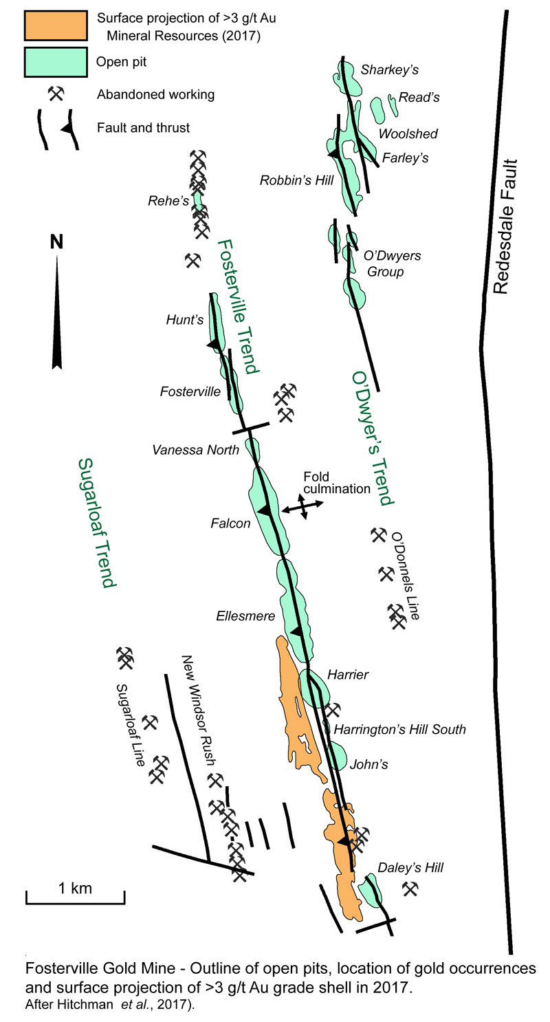
A domal fold culmination is located within the Falcon Pit in the central part of the Fosterville Mine complex, marking the intersection of tight north-south trending and gentle east-west fold axes. This culmination is the focus of fold plunge reversal. South of the culmination, the north-south fold axes plunge at ~4 to 8°S (Vollgger, 2018), and mineralisation is developed on a large west-dipping fold limb which contains parasitic folds intersected and offset by late brittle west-dipping reverse faults. These faults include the NNW trending Fosterville and similar parallel structures which closely follow the strike of bedding. Mineralisation is controlled by the intersection of faulting and bedding and plunges gently south for at least 4 km. North of the culmination, mineralisation similarly plunges gently to the north (Hitchman et al., 2017; Fuller and Hann, 2019).
Approximately 2.5 km to the NE of the culmination, in the Robbin's Hill and O'Dwyer's areas, a group of west-dipping faults parallel to, and east of, the Fosterville Fault cut the sequence and control similar zones of mineralisation. In this area, Late Silurian to Early Devonian porphyry dykes (Arne et al., 1998) up to 10 m thick intrude the stratigraphic sequence, predominantly developed along anticlinal axial planes (King, 2005; Reed, 2007) and postdate all significant faulting. The porphyry dykes are sericite altered and have associated gold mineralisation that was sufficient to support several oxide and minor sulphide open pits (e.g., O'Dwyer's South). Middle Jurassic lamprophyre dykes that follow the general Fosterville Fault trend and are unmineralised.
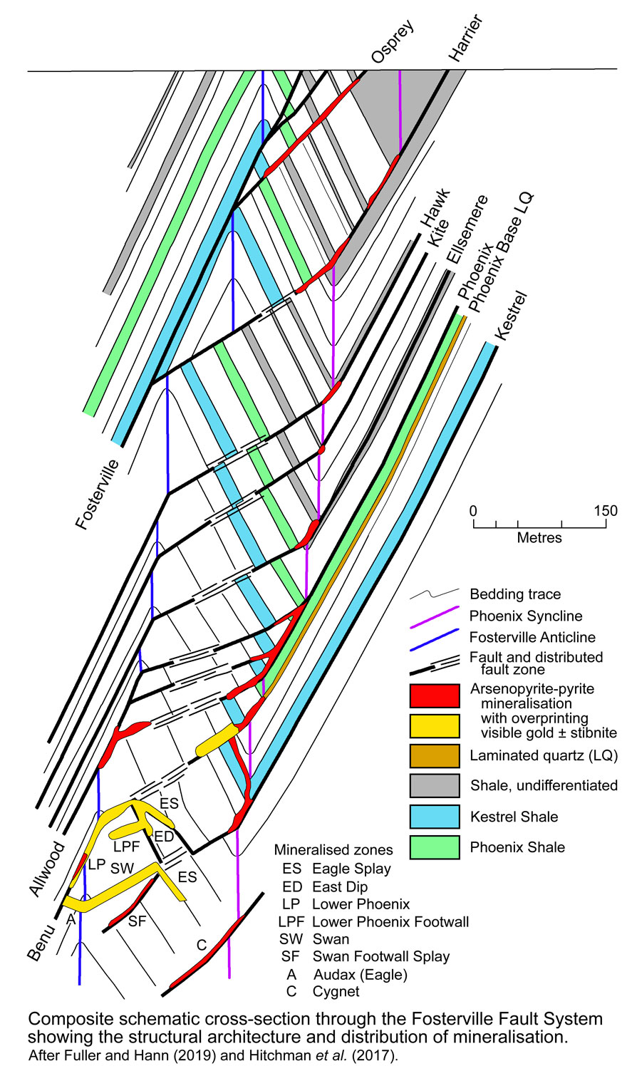
On the western limb of the main anticline, south of the fold culmination, the Fosterville Fault is accompanied by several parallel en echelon arrays of footwall reverse faults (the Hawk, Kite, Ellesmere, Phoenix and Kestrel) over a width of ~100 m to its east that are splays from the main structure. These faults are late, brittle and largely west dipping, parallel to bedding, exploiting rheological contrasts. However, when these structures cross parasitic synclines on that west dipping limb, they intersect bedding at a high angle and are discordant, before rejoining the anticlinal limb on the opposite side of the parasitic syncline and becoming bedding parallel again. Due to the reverse displacement on these faults, they shallow where discordant to bedding, forming dilated brecciated zones up to several metres in thickness on the western limb of the parasitic syncline. Where favorable rheology or stratigraphic units are encountered on this limb, conjugate east-dipping structures form, creating zones of greater structural complexity. The nature of the west-dipping faults varies as they propagate through east-dipping beds, from a simple fault in the west, past the zones of brecciation and where conjugate east-dipping satellites are formed, to a zone of barren, distributed faulting that reforms further east to become a single fracture again where crossing the parasitic synclinal axis. East of this axis, the dip of the fault steepens, matching the dip of the bedding, and the structure is occupied by bedded/laminated quartz veins, sometimes accompanied by grey clay fault pug on one margin. Where parallel to bedding, faults are generally occupied by or follow these laminated quartz veins which are interpreted to have formed during early ductile deformation. As such, these veins pre-date the introduction of gold and are generally poorly mineralised (Hitchman et al., 2017; Fuller and Hann, 2019).
The Phoenix Fault, which is a footwall splay of the Fosterville Fault, has ~120 to 150 m of reverse offset, and is the dominant fault controlling mineralisation to a depth of ~600 m in the Fosterville mineralised trend. Near surface, it is a relatively simple, narrow, west-dipping reverse fault, although down-plunge it changes to also include mineralised hanging wall splay faulting and west-dipping footwall faults emanating from bedding parallel bedded/laminated quartz veins. Other faults that are also footwall splays of the Fosterville Fault at structurally higher positions to the south and east, such as Harrier and Osprey, which have fault offsets of >200 m, are also well mineralised. Below ~600 m, sulphide gold mineralisation weakens in the Phoenix faulted syncline, but recurs at deeper levels proximal to the Lower Phoenix anticline along the lower Benu Fault (Hitchman et al., 2017; Fuller and Hann, 2019).
Mineralisation
Gold mineralisation at Fosterville is structurally controlled and localised as gently plunging elongate shoots in dilational zones developed where reverse faulting passes from concordant to being discordant to bedding, usually as a result of the presence of parasitic folding, as described above. Mineralised shoots are typically 4 to 15 m thick, 50 to 150 m wide parallel to dip and 300 to 2500 m down-plunge. The grade in these ore shoots averages 5 to 10 g/t Au, with individual assays of up to 60 g/t Au. Sulphide gold grades are relatively evenly distributed with high or low extremes being uncommon. Gold mineralisation in this setting is more continuous and of higher grades in fault zones where east-dipping beds occur adjacent to west-dipping footwall beds across a west dipping reverse fault zone or vice versa, such as along the Phoenix Fault (Boucher et al., 2008), i.e. a discordant-concordant (or oblique/parallel) structural setting. Fractures in faulted and brecciated wall rocks are healed by quartz-carbonate veining and commonly have a halo of disseminated arsenopyrite and pyrite in the walls, extending for up to 50 cm beyond the veins, but can be pervasive for hundreds of metres. The wallrock within this halo is also sericitised, sometimes with only visually subtle alteration (Fuller and Hann, 2019).
Primary gold predominantly occurs within the crystal lattice of disseminated arsenopyrite and pyrite precipitated in the sedimentary wall rocks as selvage alteration proximal to quartz-carbonate veinlet stockworks which are, in turn, controlled by the late brittle faults. The quartz-carbonate stockwork comprises a network of tension gash veinlets which formed perpendicular to the walls of the brittle faults, and on minor slip planes parallel to the brittle faults. Additional movement on the minor slip planes offset the tension gash veinlets and gave rise to a range of geometries from planar through to highly erratic. The quartz-carbonate veinlets themselves are barren, except where overprinted by later mineraising events as described below. The selvages of disseminated, fine grained arsenopyrite-pyrite, are up to 10 times the width of the veinlet on which they are centred. Where the stockwork is densely developed, mineralised selvages coalesce to form a continuous body of mineralisation (Hitchman et al., 2017; Fuller and Hann, 2019).
The total sulphide content in wallrock shale is up to 5 vol.%. The gold-bearing disseminated pyrite occurs as 0.1 to 2 mm crystalline pyritohedrons. Arsenopyrite crystals, which are the most important of the sulphide hosting gold mineralisation are 0.05 to 6 mm long acicular needles distributed in apparent random orientations, although some may aligned with cleavage (Roberts et al., 2003). Fluid inclusions from ore stage quartz-carbonate veins indicate arsenopyrite-pyrite mineralisation formed at between 140 and 385°C and depths of 2.6 to 5.7 km (Mernagh, 2001). Metallurgical and electron microscope work reveals that the arsenopyrite contains 100 to 1000 g/t Au, while the auriferous pyrite carries 10 to 100 g/t Au, with ~80% of the gold within the arsenopyrite and the remaining 20% hosted by pyrite (Roberts et al., 2003). Silver grades are very low, such that poured doré only contains ~3% Ag. Diagenetic, framboidal aggregates and laminations of pyrite up to 20 mm thick, which are common, especially in black shale units, are not auriferous (Hitchman et al., 2017; Fuller and Hann, 2019).
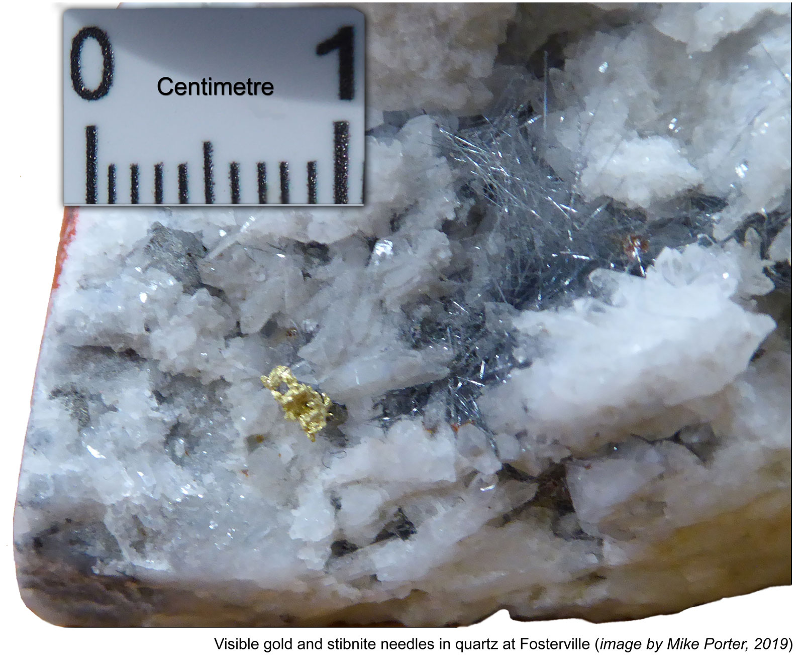
A primary visible gold event variably overprints sulphide mineralisation and occurs in quartz-carbonate veins ±stibnite. Cross-cutting relationships indicate visible gold and stibnite-quartz veining post-dates disseminated arsenopyrite-pyrite mineralisation. Although it has been encountered in all parts of the underground workings and in some open pits, visible gold apparently increases noticeably with depth and represents a change in the nature of the Fosterville mineralisation. The best example is the Eagle Zone, an east dipping splay of the Phoenix Fault at a depth of >750 m below surface. The Eagle Fault is discordant to bedding and variably dips between 10 and 60°E, transforming further to the south to strike in an ENE direction, dipping ~45°SSE. The Eagle Zone is 0.5 to 6 m thick, 50 to 80 m wide down dip and persists for >700 m down plunge. There is a substantial increase in visible gold content in the Eagle zone below 800 m depth, where the average gold grade is 15 g/t Au, although individual assays of >1% Au are encountered (Fuller and Hann, 2019). Visible gold is thought to contribute ~40% of the contained gold in this zone (Hitchman et al., 2017; Fuller and Hann, 2019).
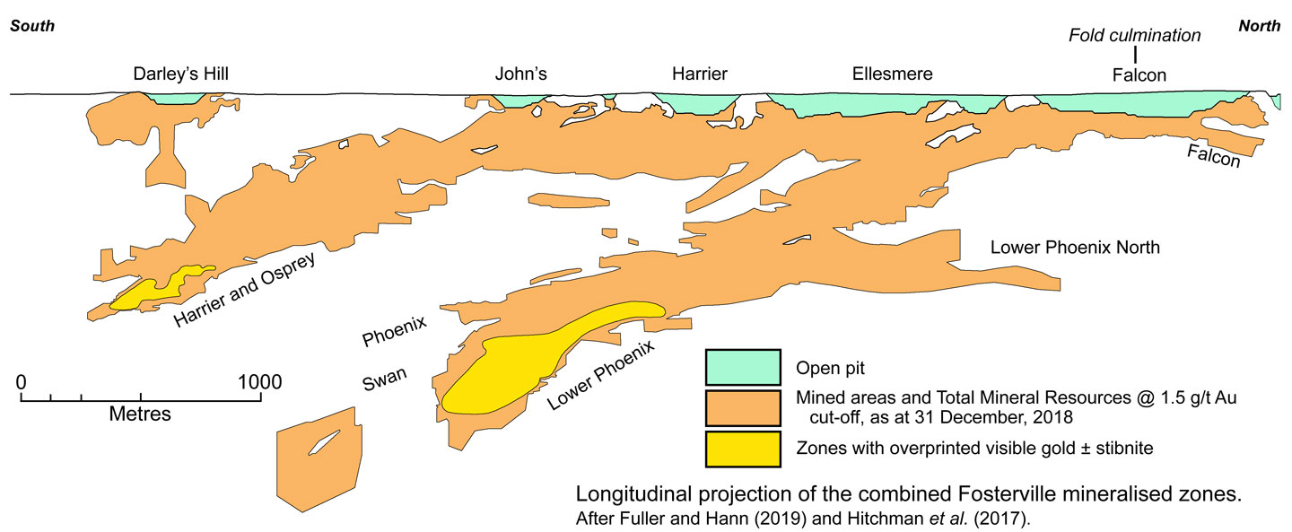
Visible gold and antimony mineralisation is also strongly developed in the footwall to the Lower Phoenix Fault and its down dip continuation, the Benu Fault, occurring as the SW-dipping Swan (previously the Lower Phoenix Footwall) Zone, which occupies a structurally rotated reverse fault splay. The Swan Fault obliquely cross-cuts the western limb of a parasitic anticline and is bounded by the Eagle Fault down-dip and the Kestrel Syncline at its upper margin. It is characterised by a 1 to 3 m thick quartz vein with various textural features. These include unique spotted stibnite and visible gold within quartz, zones of brecciation, included country rock blocks and stibnite laminations (particularly concentrated on vein margins), styolitic textures with concentrated trends of visible gold, vugs containing euhedral crystalline quartz ±sulphides and visible gold, sugary cryptocrystalline quartz textures and massive quartz zones containing specs and slugs of visible gold. On its periphery there is a lower-grade wall-rock selvage of sulphide disseminated gold mineralisation which can be up to 2 m in true width (from Fuller and Hann, 2019).
Visible gold accounts for ~10% of the total gold below 100 m along the Fosterville trend and predominantly occurs as up to 3 mm specks, although these may rarely be >5 mm across. The quartz-carbonate veins containing visible gold variably range from a few mm to several metres in width and are usually incompletely filled, with druse quartz developed within voids. The visible gold occurs as narrow linear trains of specks as well as isolated specks without a clear trend. The veins that contain visible gold include quartz-carbonate (ankerite), with minor fibrous boulangerite (Pb5Sb4S11) that occurs as inclusions in euhedral quartz or as fibrous growths within void spaces. Clear to brown sphalerite is also occasionally found within veins. Selvage sulphide alteration may also be present fringing veins hosting visible gold. There is frequently a spatial association between visible gold and antimony, chiefly in the form of stibnite (Sb2S3), although stibnite can occur without associated visible gold (Henderson, 2014). This could be explained by the stibnite and gold being introduced during separate events, but utilising the same structurally favorable locations. Visible gold is hosted within a laminated quartz-carbonate vein assemblage, which may contain minor amounts of stibnite. In the strongest mineralised zones, a broad halo of early sulphide mineralisation surrounds quartz structures replaced by later visible gold (Hitchman et al., 2017; Fuller and Hann, 2019).
Antimony mineralisation, mainly as stibnite, occurs with quartz that is sometimes vuggy. It varies from stibnite-quartz replacement and infill of earlier quartz-carbonate stockwork veins, to massive stibnite-only veins up to 0.5 m thick. Where replacing late quartz-carbonate veins, it is present as very coarse grained stibnite overgrowths up to 20 cm across which may contain 1 to 10 ppm Au. Voids infilled within the quartz-carbonate veins may be up to several metres in width. This late stibnite-quartz mineralisation appears to be restricted to splay faults and is found at depth in favorable structural locations, such as the west dipping Phoenix, Lower Phoenix and Swan vein and fault structures, as well as east-dipping faults such as Eagle which also contain visible gold. However, further to the east and north, the mineralisation is observed at shallow levels in the west dipping Harrier Fault, and as veins and pods within a felsic dyke at the O'Dwyers South open pit. As such, antimony therefore shows a spatial association with the preceding visible gold that occurs in the same setting and is observed more frequently at greater depth within the Lower Phoenix System (Hitchman et al., 2017; Fuller and Hann, 2019).
Others sulphides present at Fosterville in small quantities include galena, sphalerite and chalcopyrite, and in flotation mineral concentrates tennantite, and rare tetrahedrite, bournonite and boulangerite, aurostibnite, breithaupite and Ni-Se-sulphosalts (Hitchman et al., 2017).
There has only been minor oxidation at Fosterville. Minor remobilisation and redistribution of primary gold in the weathering profile has resulted in an ~50% increase in the width the mineralisation, with a corresponding reduction in oxide grade. No evidence has been encountered of a widespread, high grade supergene gold zone immediately below the water table (Hitchman et al., 2017).
Production, Reserves and Resources
The sulphide operation commenced in April 2005, with the plant at Fosterville Gold Mine having produced 31.125 tonnes of gold up to the end of December 2015 and 55 t by December 31, 2018. This production was initially solely from Harrier open cut with underground mining beginning from late 2006. The Harrier open cut was completed in December 2007. Since then, apart from a series of pit expansions on the previously mined Harrier, John's and O'Dwyer's South Pits during 2012 the underground mine has been the primary source of ore. Since early 2013 underground operations have been the sole provider of mill feed at Fosterville. Mining activities in 2016 focused on the Central, Phoenix and Harrier underground areas at a gold production rate of 3.4 to 3.7 tonnes per annum (Newmarket Gold, 2016). Production in 2018 was 11.08 t of Au from ore with a grade of 24.93 g/t Au.
At December 1995 the Mineral Resources totalled 4.79 Mt @ 1.1 g/t Au as oxide ore, plus 5.90 Mt @ 2.7 g/t Au primary sulphide ore.
At December 2008 Ore Reserves and Mineral Resources at Fosterville were (Northgate Minerals website, 2009):
Proved + Probable Ore Reserves - 3.617 Mt @ 4.85 g/t Au,
Measured + Indicated Mineral Resources - 9.772 Mt @ 2.05 g/t Au,
Inferred Mineral Resources - 11.114 Mt @ 3.7 g/t Au.
At 31 December 2015 Ore Reserves and Mineral Resources at Fosterville were (Newmarket Gold mineral resources report, 2016):
Proved + Probable Ore Reserves - 1.091 Mt @ 6.95 g/t Au, (included in resources)
Measured + Indicated Mineral Resources - 15.073 Mt @ 4.39 g/t Au,
Inferred Mineral Resources - 5.073 Mt @ 4.08 g/t Au.
Measured Mineral Resources and Proved + Probable Ore Reserve CIL residues - 0.571 Mt @ 7.83 g/t Au.
At 31 December 2018 Ore Reserves and Mineral Resources at Fosterville were (Kirkland Lake Gold, Reserves and Resource Statement 2019):
Proved + Probable Ore Reserves - 2.72 Mt @ 31 g/t Au, (NOT included in resources)
Measured + Indicated Mineral Resources - 14.80 Mt @ 4.4 g/t Au,
Inferred Mineral Resources - 10.30 Mt @ 5.5 g/t Au.
Measured + Indicated + Inferred Mineral Resources - 25.10 Mt @ 4.85 g/t Au.
Cut-off grades are 0.7 g/t for oxide and 1.0 g/t Au for open pit sulphide ores to a depth of 100 m and 3.0 g/t for those deeper.
NOTE: The 2018 Ore Reserves do not include 0.649 Mt @ 7.7 g/t for 4.98 t of Au in Carbon-In-Leach Residues with a 25% recovery expected, based on past operating performance.
Some of the information in this summary is derived from "Fuller, T. and Hann, I., 2019 - Fosterville Gold Mine, in the State of Victoria, Australia; an NI 43-101 Technical Report prepared for Kirkland Lake Gold Ltd., 256p".
The most recent source geological information used to prepare this decription was dated: 2019.
Record last updated: 9/10/2019
This description is a summary from published sources, the chief of which are listed below.
© Copyright Porter GeoConsultancy Pty Ltd. Unauthorised copying, reproduction, storage or dissemination prohibited.
Fosterville
|
|
|
|
|
Anonymous 1998 - Fosterville: in Register of Australian Mining 1997/98 p 229-230
|
Arne D C, Bierlein F P, McNaughton N, Wilson C J L and Morand V J, 1998 - Timing of gold mineralisation in western and central Victoria, Australia: New constraints from SHRIMP II analysis of zircon grains from felsic intrusive rocks: in Ore Geology Reviews v13 pp 251-273
|
Boucher, R.K., Rossiter, A.G., Fraser R.M. and Turnbull, D.G., 2015 - Review of the structural architecture of turbidite-hosted gold deposits, Victoria, Australia: in Trans. IMM (incorp. AusIMM Proc.), Section B, Appl. Earth Sc. v.124, pp. 136-146.
|
Hitchman, S.P., Phillips, N.J. and Greenberger, O.J., 2017 - Fosterville gold deposit: in Phillips, G.N., (Ed.), 2017 Australian Ore Deposits, The Australasian Institute of Mining and Metallurgy, Mono 32, pp. 791-796.
|
Hughes, M.J. and Phillips, G.N., 2015 - Mineralogical domains within gold provinces: in Trans. IMM (incorp. AusIMM Proc.), Section B, Appl. Earth Sc. v.124, pp. 191-204.
|
McConachy G W and Swensson C G, 1990 - Fosterville Gold Field: in Hughes FE (Ed.), 1990 Geology of the Mineral Deposits of Australia & Papua New Guinea The AusIMM, Melbourne Mono 14, v2 pp 1297-1298
|
Roberts C, Jackson T, Allwood K, Shawcross M, Story J, Barbetti L, Tielen R, Boucher R and Norris N, 2003 - Fosterville - Rise of the Phoenix, the emerging goldfield at Fosterville: in NewGenGold 2003, Conference Proceedings, Perth WA, Louthean Media, Perth pp 200-213
|
Voisey, C.R., Tomkins, A.G. and Xing, Y., 2020 - Analysis of a Telescoped Orogenic Gold System: Insights from the Fosterville Deposit: in Econ. Geol. v.115, pp. 1645-1664.
|
Wang G M and White S H, 1993 - Gold mineralization in shear zones within a turbidite terrane, examples from Central Victoria, S.E. Australia : in Ore Geology Reviews v8 pp 163-188
|
Zurkic, N., 1998 - Fosterville gold deposits: in Berkman D A, Mackenzie D H (Ed.s), 1998 Geology of Australian & Papua New Guinean Mineral Deposits The AusIMM, Melbourne Mono 22 pp 507-510
|
|
Porter GeoConsultancy Pty Ltd (PorterGeo) provides access to this database at no charge. It is largely based on scientific papers and reports in the public domain, and was current when the sources consulted were published. While PorterGeo endeavour to ensure the information was accurate at the time of compilation and subsequent updating, PorterGeo, its employees and servants: i). do not warrant, or make any representation regarding the use, or results of the use of the information contained herein as to its correctness, accuracy, currency, or otherwise; and ii). expressly disclaim all liability or responsibility to any person using the information or conclusions contained herein.
|
Top | Search Again | PGC Home | Terms & Conditions
|
|


