|
Tenke-Fungurume - Kwatebala, Goma, Fwaulu |
|
|
Katanga, Dem. Rep. Congo |
| Main commodities:
Cu Co
|
|
 |
|
|
 |
Super Porphyry Cu and Au


|
IOCG Deposits - 70 papers
|
All papers now Open Access.
Available as Full Text for direct download or on request. |
|
|
The Tenke-Fungurume sediment-hosted copper-cobalt deposits are located within the northern apex of the ~350 km long Congolese Copperbelt, in Katanga Province of the Democratic Republic of Congo, the northern section of the larger Central African Copperbelt that extends south into Zambia. The deposits are ~75 to 100 km east of Kolwezi (#Location: Kwatebala - 10° 34' 49"S, 26° 11' 12"E; Goma - 10° 35' 47"S, 26° 8' 0"E).
Copper has been mined at Tenke-Fungurume for over 500 years, based on dating of the historic slags at Luanzo Tshilongo (John, 1873; Verbeeken and Walrat, 1954). The first mention of the Fungurume cluster of deposits was in Büttgenbach (1904). Following construction in 1909 of a smelter for Union Miniére du Haut Katanga (UMHK) at Lubumbashi, 180 km to the SE (Sharp, 1946; Pirard, 2011), mechanised mining commenced in Katanga. A railway line was constructed to Tenke-Fungurume in 1917, including a large cut through the Fungurume VII deposit. Exploration was started by the Comité Spécial du Katanga (CSK) and by UMHK in 1919, with the first diamond core hole being drilled in 1930 in the Dipeta Valley.
Most of the main deposits were progressively outlined by 1966, and in 1971, a consortium, Societe Miniére de Tenke Fungurume (SMTF), led by Anglo American's Charter Consolidated, began to develop the project, only to abandon it in 1976 due to perceived political risk. No industrial scale mining took place until 2006, when Phelps-Dodge started and Freeport McMoRan (FCX) as manager of Tenke Fungurume Mining (TFM; a partnership between FCX, Lundin Mining and Gecamines) developed, the Kwatebala orebody, east of Tenke. The first copper cathode was produced in 2009. Mining has since also commenced at the Fwaulu (Fwalu, Faulu) and Shimbidi pits (Schuh et al., 2012, and references cited therein). The Mwadinkomba, Kansalawile, Fungurume, Mambilima and Pumpi deposits are also included in the long term mine plan.
In May 2016, Freeport-McMoRan sold their interest in the project to China Molybdenum Company Limited (CMOC).
Regional Setting
For details of the regional setting of the Tenke-Fungurume district, the Central African/Congolese Copper Belt and the Lufilian Arc, see the separate Central African Copperbelt - Congolese/Katangan Copperbelt record.
Geology
The oldest rocks at Tenke-Fungurume belong to the Roan Group of the Neoproterozoic Katanga Supergroup, commencing with the R.A.T. Subgroup (Roches Argilo-Talqueuses; R-1), which is separated by a thrust/detachment surface from underlying, but younger, Nguba and Kundelungu group rocks. At Tenke-Fungurume, the R.A.T. Subgroup comprises >200 m of purple to red, hematitic, evaporitic, lacustrine siltstones and mudstones (R.A.T. Lilas) that are mostly brecciated. It is now principally composed of polymictic, angular to rounded clasts in a sand to silt sized matrix of talc, dolostone, quartz and Mg-rich chlorite, interpreted to be friction brecciated residues, following liquefaction of evaporite beds, and the expulsion of brines during decollement faulting that was 'lubricated' by those beds (Schuh et al., 2012; Cailteux and Kampunzu,1995). Age dating suggest the R.A.T. Subgroup clastic sediments were derived from the Palaeoproterozoic Eburnian basement volcanosedimentary rocks of the Bangweulu Block to the NE (Schuh et al., 2012 and references cited therein).
 The sequence that overlies the R.A.T. Lilas at Tenke-Fungurume may be summarised as follows (after Schuh et al., 2012 and references cited therein), from older to younger:
Mines Subgroup (R-2), which is ~225 m thick, and hosts 98% of the known copper-cobalt deposits in the Tenke-Fungurume district, principally within the D.Strat., R.S.F., S.D.B. and S.D. units, as described below.
Kamoto Formation (R-2.1).
* R.A.T. Grises, (R-2.1.1) - 2 to 5 m of grey and white-bleached sandstones, representing R.A.T. Lilas facies from which the ferric iron has been removed by reduced copper-mineralising fluids.
* D.Strat., (R-2.1.2) - 2 to 5 m of stratified, silicified dolostone, characaterised by anhydrite nodules indicating evaporite facies, grading up into,
* R.S.F., (also R-2.1.2) - 8 to 12 m of silicified, laminated, algal dolostones, which contain the bulk of the copper ore, occurring as malachite in the oxide zone and sulphides below the base of oxidation.
* R.S.C., (R-2.1.3) - 20 to 30 m of largely barren to low grade silicified, cavernous and porous, stromatolitic dolostone, containing coarse vugs, with 1 to 2 m thick lenses of cobalt-rich tan mudstone (schistes intercalaires).
Dolomitic Shales Formation (R-2.2).
* S.D.B. - 5 to 8 m of thin, platy, laminar, sericitic to hematitic, dolomitic siltstone and shale.
* S.D. - a 60 to 100 m thick suite of dolostone and dolomitic siltstone, punctuated by three pyritic black shale beds defining three cycles.
Kambove Formation (R-2.3).
* C.M.N., ~100 m thick, comprising a lower (R-2.3.1) ~65 m of grey, stromatolitic, laminated, shaly or talcose dolostones, with two black horizons, one near the base, the other near the top; and an upper (R-2.3.2) 40 m of light grey to white, stromatolitic, laminated, shaly, or talcose dolostones.
Dipeta Subgroup, (R-3) ~600 m thick, which displays a sedimentary sequence that is similar to the R.A.T. Lilas and overlying Mines subgroups, raising speculation that it represents a structural repetition of those units. It has been divided into,
R.G.S. Formation, (R-3.1) ~155 m thick, which commences with 10 m of reddish, fine-grained siltstone, overlain by ~25 m of arkosic sandstones with dolomitic horizons and argillaceous, dolomitic siltstones, followed in turn, by ~120 m of alternating grey or white dolostones with grey dolomitic shales and green pelitic horizons.
Lower Mofya Formation, (R-3.2) comprising a lower 30 m of purplish-grey sandy pelites, overlain by 21 m of dolostone with banks of greenish sandy pelites and one stromatolitic horizon.
Upper Mofya Formation, (R-3.3), commencing with >100 m of purplish-grey sandy pelites, overlain by a hiatus, occupied by silty breccias, interpreted to represent a dissolved evaporite horizon (François, 1992). This is followed by 50 m of grey, massive, vuggy dolostone; then 19 m of sandy, pyritic dolostone with asbestos (riebeckite,
crocidolite); 98 m of dolostones and marly dolostones, with an oolithic horizon, andalusite porphyroblasts in the middle, and another oolithic horizon near the top.
Kansuki Formation, (R-3.4), which starts with 60 m of fine, hard, purple, sandstone, overlain by >34 m of light-colored dolostone with one stromatolithic unit at the base. This is followed by a second a hiatus, occupied by silty breccias, interpreted to represent a dissolved evaporite horizon (François, 1992). The break is succeeded by a zone of strongly faulted rocks at the base of an ~20 m interval of fine sandy psammitic shales, alternating with dolomitic marls, and 1 or 2 stromatolithic horizons, followed, in turn, by 10 m of silicified dolostone with oolithic and hematitic horizons.
Mwashya Subgroup (R-4), ~130 m thick, the uppermost Roan Group member, has been divided into:
Kamoya Formation, (R-4.1), ~45 m of dolomitic silty shales, siltstones, sandstones, conglomerates and cherts.
Kafubu Formation, (R-4.2), ~75 m of finely bedded, black carbonaceous shales.
Kanzadi Formation, (R-4.3), ~10 m of feldspathic, sandstones and conglomerates.
Nguba Group, ~1800 m of platform sediments which were deposited between 735 (Key et al., 2001) and 635 Ma, commencing with the ~730 m thick basal Grand Conglomérat (Ng-1.1), followed by a thin unit of banded shale and dolostone beds (Ng-1.2), the carbonate rocks of the Kakontwe Formation (Ng-1.3), the Kipushi Formation (Ng-1.4) dolostones with dolomitic shales, and a further 935 m (Ng-2) of dolomitic sandstones, siltstones and pelites.
Kundelungu Group, ~3100 m thick, deposited between 635 and 573 Ma (Master et al., 2005), commencing with the basal Petit Conglomérat diamictite, followed by limestone, siltstone and sandstone.
During late Kundelungu Group time, sedimentation north of Tenke-Fungurume formed the flat-lying syn- to post-orogenic siliciclastic rocks of the Plateaux Subgroup of the Plateau des Biano area, interpreted to represent a continental molasse (Kampunzu and Cailteux, 1999) related to the Lufilian orogenic event. The Lufilian event lasted from ~530 Ma (John et al., 2004), until about 500 Ma, and is the local manifestation of the Pan-African orogeny. Tenke-Fungurume lies within the thin-skinned thrust and fold belt and margin of the foreland zone of the resultant Lufilian Arc.
Only Tertiary aeolian Kalahari sands and Late Cenozoic valley-fill sediments overlie the Katanga Supergroup.
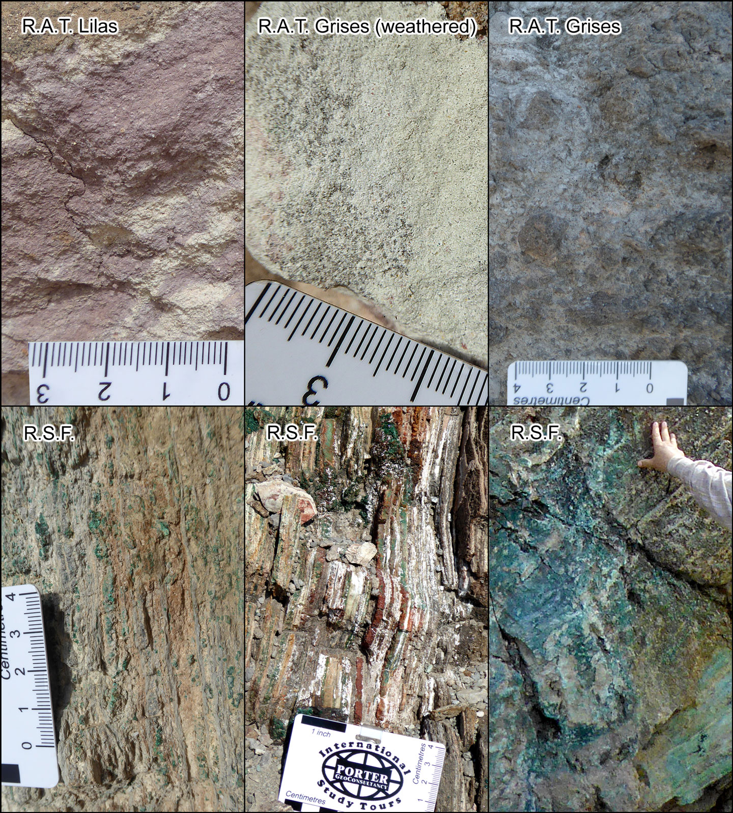
Key Mines Subgroup lithologies at Tenke-Fungurume - Set of images above:
R.A.T. Lilas or Roches Argilo-Talqueuses Lilas (upper left) - the lowest unit of the Roan Group, always with a structural base, overlying younger Kundelungu Group rocks. A lilac to red, largely structureless, dolomitic to talcose and argillaceous silt to sandstone that may be >200 m thick. This example is outcropping and weathered from the Mwadinkomba deposit area.
Grey R.A.T. or Roches Argilo-Talqueuses Grises. Two images:
• (upper row, centre) - 2 to 5 m of white, bleached variety of the R.A.T. Lilas. This sample is weathered, outcropping adjacent to the Mwadinkomba deposit.
• (upper row, right) - a grey, reduced specimen, which is brecciated, and less weathered than the previous sample. It is from the oxide zone in the upper benches of the Kwatebala pit.
R.S.F. or Roche Siliceuses Feuilletées (laminated siliceous rock) - a 10 to 15 m thick, thinly and regularly laminated silicified algal dolostone, which, with the intervening 2 to 7 m thick D.Strat. (not represented in this collage), hosts the Lower Orebody. Three images:
• (lower row, left) - a sample from outcrop adjacent to the Mwadinkomba deposit.
• (lower row, centre) - this sample is from the oxide zone in the upper benches of the Kwatebala pit.
• (lower row, right) - this sample contains high grade mineralisation from the oxide zone in the Tenke area and is less weathered than the previous two exposures.
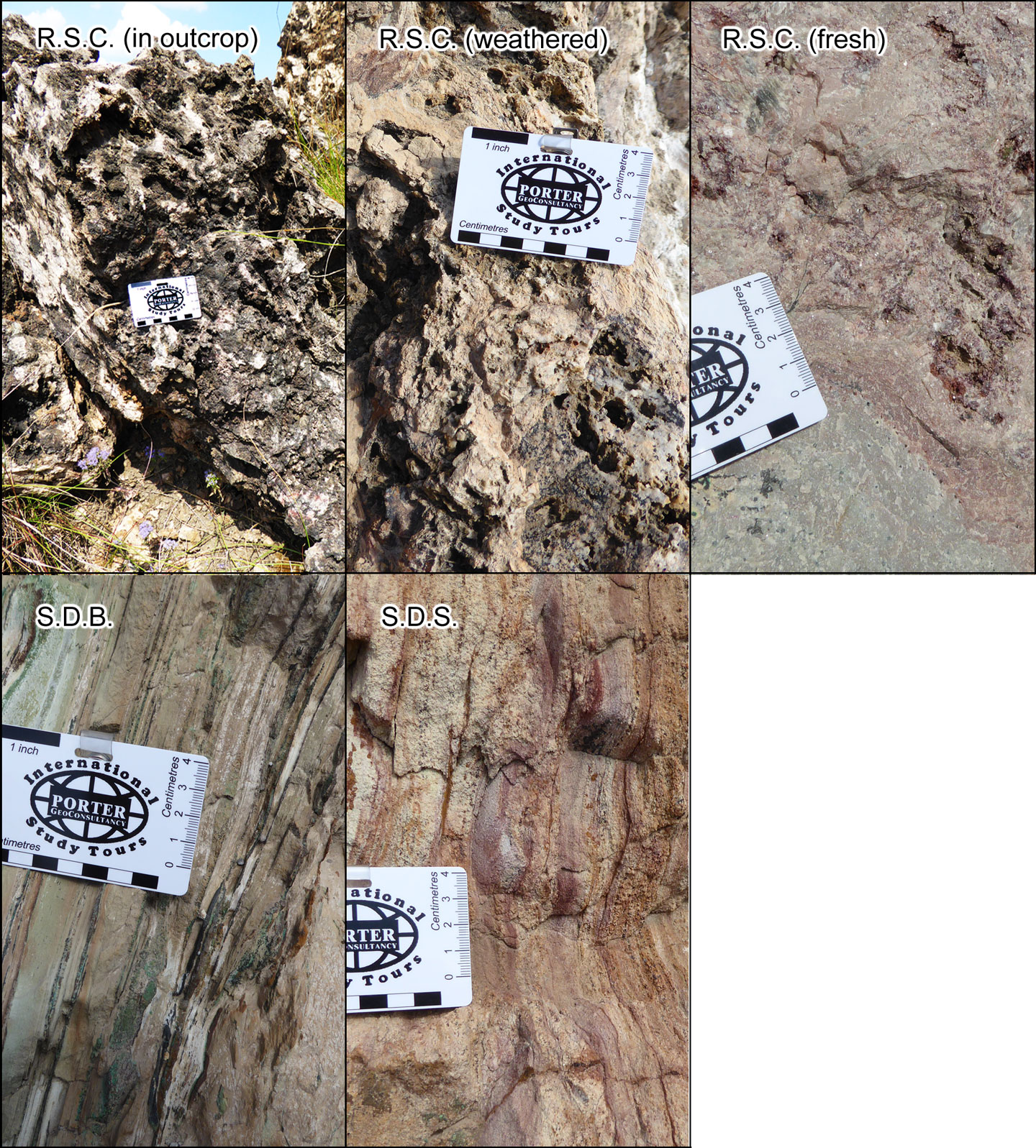
Set of images below:
R.S.C. or Roches Siliceuses Cellulaires. Three images:
• (upper row, left) - in outcrop, illustrating the siliceous-cellular texture of the weathered rock from which it derives it's name.
• (upper row, centre) - this sample is from near the surface in the Kwatebala pit. It also exhibits the siliceous-cellular textures from dissolution of carbonates.
• (upper row, right) - massive, sometimes cavernous, strongly silicified, stromatolitic dolostone, which is 20 to 35 m thick and is generally barren in the hypogene zone, but may contain rich supergene ore. This massive, originally porous reefal facies rock, separates the laminated, carbonaceous rocks of the R.S.F. and S.D.B. that host the Lower and Upper orebodies. This sample is unweathered from the primary zone deeper in the Kwatebala pit.
S.D.B. or Schistes Dolomitiques Basal (lower row, left) - which immediately overlies the R.S.C. and hosts the Upper Orebody. It comprises thin, platy, laminar, sericitic to hematitic, dolomitic siltstone and shale. This sample is from the oxide zone in the upper benches of the Kwatebala pit.
S.D.S. or Schistes Dolomitiques Superieures (lower row, right) - a more sandy suite of dolostone and dolomitic siltstone occurring above the Upper Orebody. This sample is also from the upper benches of the Kwatebala pit.
Photographs by Mike Porter, May 2014.
Structural Setting
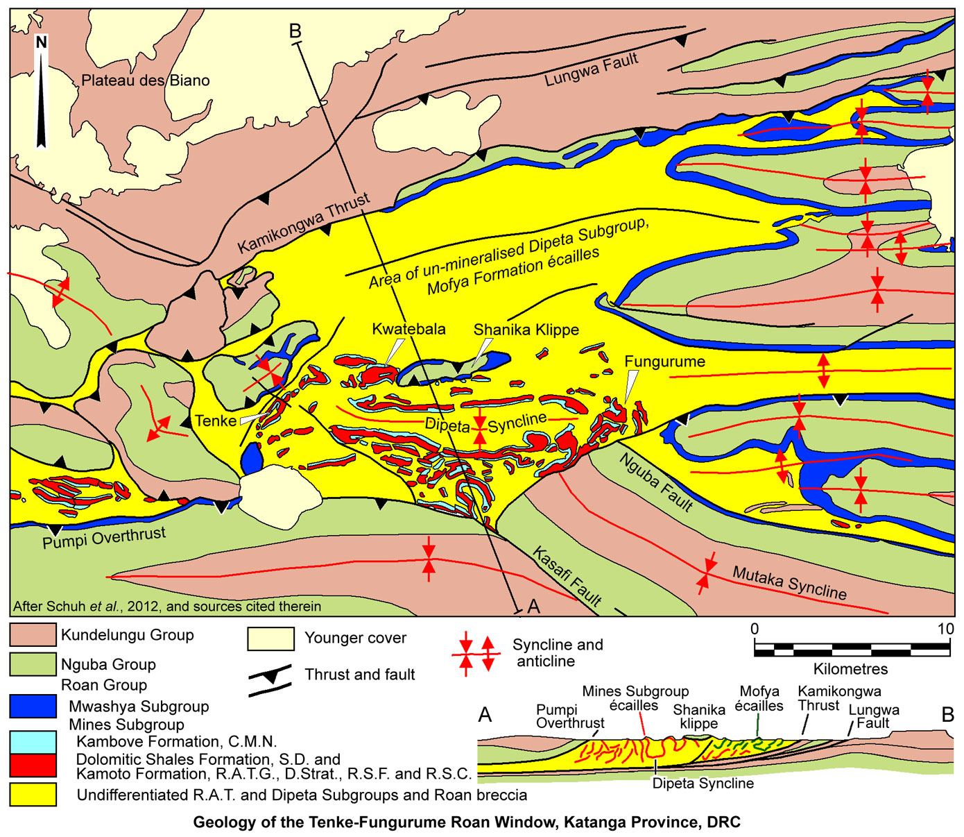
The Tenke-Fungurume district occupies the northern apex of the Lufilian Arc, straddling a change in structural grain, from a north-south directed high compressional regime in the west, which has an east-west trend, to moderate, NW-SE trending folds in the east (Schuh et al., 2012; Hitzman et al., 2012).
The ore deposits of the district, all lie within the >500 km2 Tenke-Fungurume tectonic window of Roan Group megabreccias (the Roan window), surrounded by Nguba and Kundelungu lithotectonic assemblages. This is the largest such window in the Central African Copperbelt. It comprises a large expanse of exposed Roan Group rocks, located at the junction of several NW-SE and east-west Roan-cored anticlines, and marks the northern end of the major NW-trending Kakanda anticline that hosts numerous other significant deposits, from Kakanda and Kambove to Luishia, Luiswishi and Étoile (Schuh et al., 2012 and references cited therein).
The northern margin of the Roan window is defined by the ENE to east-west trending, south-dipping Kamikongwa thrust, a major north vergent regional structure, above which the allochthonous Roan Group sequence/megabreccia is thrust over less deformed Nguba and Kundelungu groups rocks. To the north, an east-west corridor, bounded to the south by the Kamikongwa thrust, and 2 to 5 km to the north by a subparallel structure, the Lungwa Fault, is characterised by three ENE trending, thrust fault dislocated anticlines of Nguba and Kundelungu groups rocks only. To the north of the Lungwa Fault, flat-lying, undeformed upper Kundelungu molassic sedimentary rocks of the Plateaux Subgroup dominate, disconformably overlying the lower Kundelungu sequence (Schuh et al., 2012).
Some 10 to 15 km south of the Kamikongwa thrust, the southern margin of the Roan window is more complex, defined by the similarly south-dipping, north vergent Pumpi overthrust, complicated by normal to strike-slip transfer structures at oblique to high angles to the main thrust plane. Overall these southern structures facilitate thrusting of nappes of Nguba and Kundelungu groups rocks over the Roan Group sequence/megabreccia (Schuh et al., 2012). One of the normal faults on the southern margin of the window, the NE striking "faille de Fungurume" (François, 2006), truncates the regional NW-SE trending Kakanda anticline, and is interpreted to represent a diapir edge, or salt weld (Hitzman et al., 2012 and references cited therein).
The eastern margin of the Roan window is characterised by a series of parallel, east-west trending synclines and intervening faulted anticlines that down-fold eastward converging fingers of Nguba and Kundelungu groups rocks onto the Roan Group.
Seven fault-bounded, pancake-shaped, thrust klippen ("lambeaux"), 'floating' on Roan megabreccias, cover the western part of the Roan window, where the Kamikongwa and Pumpi thrusts converge. They are 1 to 3 km across and comprise Nguba-Kundelungu groups lithologies that are very gently folded but with fold axes in variable directions (François, 1973, 2006; Jackson et al., 2003).
Schuh et al. (2012) suggest the main Roan Group assemblage was transported northward and emplaced ("extruded") onto an unknown surface during the main Lufilian orogeny compression (peak ~530 Ma). The flat lying klippen ("lambeaux") of Nguba-Kundelungu groups rocks in the western Roan Window accompanied this phase. The same authors then interpret the major thrust structures which emplaced the Roan Group melange over Nguba-Kundelungu rocks to the north, and thrust further Nguba-Kundelungu rocks over the Roan assemblages to the south, to have been a separate late Lufilian orogeny event (~520 to 500 Ma). There are thickness and facies differences between Nguba-Kundelungu groups rocks in the "lambeaux", the northern block and the southern overthrust sheet, where in addition, a major NW-SE fault separates two suites of these rocks. These differences support telescoping and stacking of thrust sheets from different parts of the Katanga basin.
The Roan Group megabreccia within the window, is composed of a chaotic matrix of rock flour through silt and gravel sized talc, dolostone, quartz and Mg-rich chlorite, as well as larger blocks of clastic and carbonate rocks, derived from undifferentiated, polymictic R-1 and R-3 lithologies. The matrix encases scrambled blocks or écailles of Mines Subgroup (R-2) rocks as well as larger masses of less disrupted R-1 and R-3 lithologies. Écailles is French for 'fish-scales', a local structural term for tabular tectonic blocks within megabreccias. The écailles are typically several tens to >1000 m in length and down-dip, and from 20 to >200 m thick, although individual blocks may be up to 5 km long and persist down dip for >1800 m. They form tight, upright or recumbent anticlinal or monoclinal structures, or fragments thereof, but relatively few Mines Subgroup écailles form synclines. The cores of tight anticlines are filled with R-1 breccia material that has flowed like toothpaste. However, the R-1 and R-3 megabreccia lithologies frequently form synclinal structures between the écailles.
The south-central section of the Roan window is dominated by the ~20 km long, east-west trending, apparently upright and tightly to isoclinally folded, Dipeta syncline (Schuh et al., 2012). This structure, which closes to both the east (Fungurume area) and west (Tenke-Goma area), has an axial zone of brecciated Dipeta Subgroup rocks, flanked on both sides of its long axis, by relatively undisturbed, and consistently inwards-facing, Mines Subgroup écailles. The Mines Subgroup écailles/limbs, which are steeply dipping, culminate upward, into dominantly flat-lying, mushroom-shaped caps and flower structures, and frequently comprise disrupted, overturned, isoclinal anticlinal folds, composed of multiple, complexly stacked blocks. The eastern and western closures of the Dipeta syncline are marked by clusters of more chaotically oriented blocks, particularly at Fungurume (Schuh et al., 2012).
The Dipeta syncline is a gently box-folded recumbent fold with steep to overturned flanks and a relatively flat bottom. It may represent a 'sunken' synform, which collapsed when the underlying evaporites migrated into flanking near vertical salt walls, updoming the northern and southern anticlines and tilting the Mines Subgroup écailles which were sandwiched by R-1 and R-3 (R.G.S.) breccias. This folding was pre-Lufillian, but was probably initiated by the cumulative mass of thick overlying Nguba and Kundelungu groups rocks (Schuh et al., 2012).
Mines Subgroup écailles only crop out in the southern half of the Roan window, where virtually all of the known economic copper-cobalt orebodies are located. A 15 km long, east-west trending, 5 to 7 km wide belt of the Mofya Formation (R-3.2 and R-3.3), part of the Dipeta Group, is found within the northern part of the window, with a tectonic deformation style that is comparable to that of the Mines Subgroup (i.e., convoluted isoclinal folds, subvertical dips, broken folds), suggesting both R-3 and R-2 underwent the same type of structural deformation. In contrast, the Nguba and Kundelungu group packages form gently folded synclines and are generally east-west trending (Schuh et al., 2012; Hitzman et al., 2012 and references cited therein).
Mineralisation and Alteration
The bulk of the ore at Tenke-Fungurume occurs within écailles of the Mines Subgroup in the southern part of the Roan window, and is present in the lower part of the subgroup, immediately above the regional oxidation-reduction lithogeochemical contact between underlying, red, hematitic, oxidised RAT lilas (R-1) and the reduced lower units of the overlying Mines Subgroup, the normally grey R.A.T. Grises (R-2.1.1) and/or D.Strat. (R-2.1.2). There is ~120 km strike length of the potentially mineralised intervals within écailles in the southern part of the Roan window.
Not all megabreccia-hosted écailles within the Roan window are economically mineralised, although they all display broadly similar alteration styles. Within the Tenke-Goma (west) and Fungurume (east) clusters only 5 of 12 and 3 of 9 blocks, respectively, are well mineralised (Hitzman et al., 2012).
 Mineralisation is stratigraphically distributed within the 20 to 45 m thick mineralised interval of the Mines Subgroup, as follows (after Schuh et al., 2012):
Lower orebody - mineralisation first appears in the R.A.T. Grises, (R-2.1.1) and D.Strat.-R.S.F., (R-2.1.2), which hosts 60 to 80% of the contained metals. The bulk of the ore is in the D.Strat. and R.S.F., with <5% of the total in the R.A.T. Grises. Below the supergene-oxide zone, primary chalcocite, bornite and carrollite are the most common ore minerals in the D.Strat. and R.S.F., with minor chalcocite and pyrite. Chalcopyrite and pyrite are most common in the R.A.T. Grises, with local high bornite. The lower ore zone varies between 5 and 15 m in thickness.
Intermediate zone - that separates the Lower and Upper orebodies, and comprises the largely barren, 15 to 30 m thick R.S.C. (R-2.1.3), which may, however, locally contain 10 to 15% of the ore, mainly as secondary mineralisation. Primary disseminated coarse carrollite grains occur in the R.S.C., but rarely reaches ore grade.
Upper orebody - principally hosted by the basal 5 to 12 m thick S.D.B., but in part infiltrates the overlying lower cycle of the S.D. (R-2.2). Chalcopyrite is the most common sulphide ore mineral in the SDB, with minor bornite.
The best grades are in the R.S.F. and S.D.B, on either side of the barren to low grade, silicified, massive, stromatolite R.S.C. unit. The individual orebodies, which range in strike and down-dip extent from several tens to several hundreds of metres, are typically fault-bound, i.e., the ore is truncated by the faulted margin of the host écaille, implying ore formation predated the creation of the megabreccia.
Mineralisation is divided into the following styles (after Schuh et al., 2012):
* Supergene oxides - which represent the bulk of the mineable resources, and normally extend to depths of 80 to 150 m below surface, but may be much deeper (e.g., at Fungurume, native copper occurs at 990 m depth; Oosterbosch and Schuiling, 1951; and at Pumpi, malachite occurs deeper than 430 m). The principal oxide minerals are copper and cobalt carbonates (malachite, azurite, cobaltoan dolomite), phosphates (libethenite, pseudomalachite), silicates (chrysocolla) and oxides (cuprite, heterogenite), with copper predominantly occurring as malachite (91%), pseudomalachite (9%) and trace libethenite, while oxide cobalt is mainly dark brown heterogenite. The best near surface oxide ores are at depths of from 15 to 30 m.
The main oxide zone passes down into a mixed oxide-sulphide interval that typically occurs to depths of 50 to 200 m below the surface, and is characterised by pink cobaltoan dolomite, chrysocolla and supergene chalcocite, with minor covellite and digenite replacing earlier sulphide phases. The base of mixed sulphides is highly variable, from 50 to >400 m depth. Leached cappings are in general, not well developed (due to carbonate buffering), although they are found to depths of 50 to 80 m down-dip along acid-leachable, hydrologically favourable units, underlain by exceptionally rich oxide ore developments. Supergene mineralisation has been dated at 10 to 5 Ma and 5.3 to 2.3 Ma associated with Miocene to Pliocene uplift during a period of aridity.
* Stratabound sulphides - early-stage, disseminated copper sulphide minerals are, in order of decreasing abundance: chalcocite, bornite, carrollite and chalcopyrite. Carrollite, bornite, chalcopyrite and digenite also occur as small inclusions in quartz grains. The majority (85 to 90%) of the sulphides of the district are strata bound, occurring as:
i). Fine disseminations - occurring as interstitial, <100 µm, bornite, carrollite, chalcopyrite and chalcocite within all units of the mineralised Mines Subgroup. Sulphide grains are of comparable size to the enclosing non-sulphide minerals, and may occur alone, or associated with secondary quartz and dolostone.
ii). Coarse, blebby grains - which are coarser than enclosing non-sulphide minerals, and are lithologically controlled, predominantly found in the dolomitised
evaporite-bearing dolosiltstone layers of the D.Strat. and S.D., coarse dolostone beds of the R.S.F., and as characteristic mm to cm-sized carrollite crystals in the silicified parts of the R.S.C. They are interpreted to be replacements of evaporite minerals and of coarse-grained dolomite crystals by quartz and sulphides.
iii). Nodules - are ubiquitous at Tenke-Fungurume, most commonly in the D.Strat., R.S.F. and S.D.B. units. Sulphide-bearing nodules typically have dominantly coarse dolomite and quartz interiors, with irregularly intergrown pyrite and chalcopyrite toward their rims. Quartz and dolomite preserve small inclusions of remnant anhydrite and rare barite. Quartz-dolomite contacts are polygonal, indicating evaporitic replacement.
iv). Jack veins - fibrous, bedding-parallel, sulphide-carbonate veins without selvedges, occurring predominantly in organic-rich shale beds of the R.S.F. and D.Strat., most likely formed early, during burial and compaction of shales as a consequence of overpressuring beneath hydrologically impermeable evaporite beds. These veins may have been reactivated and recrystallised during Lufilian deformation.
v). Fine laminations - bedding-parallel bands of sub-mm thick early pyrite-copper (-cobalt) sulphides occurring in the R.S.F., S.D.B. and S.D. units, accompanied by only minor dolomite or quartz. Assemblages in the R.S.F. are commonly bornite rich when associated with dolomite-quartz beds and contain carrollite and dolomite in more phengite-illite-Mg-chlorite rich beds. Laminations in the S.D.B. contain pyrite-chalcopyrite with fine-grained muscovite-chlorite bands. The three shale members of the S.D. above the Upper orebody commonly contain very fine, pyritic, diagenetic laminations.
* Crosscutting hypogene sulphides - in late-stage, commonly fibrous, veins with variable alteration selvedges. These veins cut earlier, bedding parallel veining at Tenke-Fungurume, and are best developed and most abundant in zones of complex deformation, e.g., in fold noses, adjacent to major faults and R.A.T.-bounded nose ends of elongate écailles. Where this stage of veining is more intense in such structurally complex zones, Cu grades may be significantly enhanced. Sulphide minerals within these veins are dominantly chalcocite, with only minor bornite, carrollite and rare chalcopyrite. Textural evidence suggests that most of the chalcocite has replaced earlier sulphide phases. Fluid inclusions indicate mineralisation was related to a separate, hotter, and more saline fluid than the early stratabound sulphides (Muchez et al., 2008; El Desouky et al., 2009). These veins occur throughout the Mines Subgroup, but not the R.A.T. Lilas, where dolomite-hematite crackle breccia veins may represent the syn- and post-folding equivalent. At Tenke-Fungurume, ~86% of the oxide ore is strata bound, whereas the remaining 14% occurs in crosscutting veins. The ratio for primary sulphide ores is 90% strata bound to 10% in veins.
Alteration textures within the ore zone suggest at least four magnesian alteration stages and three or more silicification events occurred. Magnesian alteration and silicification are the dominant alteration types associated with sulphide mineralisation. On a district scale, a broad sodic zone mostly affected R3 Dipeta Subgroup rocks, possibly representing a halo hundreds of metres or more distal from ore, but equally, may also constitute a separate late event. In contrast, potassic alteration is only minor. However, the sequence of alteration resembles progressive evaporation of seawater to produce residual bittern brines successively enriched in Ca, Na, then Mg, and finally K (Schuh et al., 2012).
The alteration profile across the orebody, comprises massive silica flooding in the central barren to low grade Intermediate zone, decreasing outward, above and below for 1 to 2 m into the Upper and Lower orebodies. In the lower sections of the overlying Upper orebody, the S.D.B, has high Cu grades, strong dolomite, and high sericite alteration, passing upwards into the lower S.D., with lesser dolomite and more silica (possibly in part reflecting the siliciclastic host) as the Cu grade fades.
Immediately below the siliceous Intermediate zone (R.S.C.), the R.S.F. in the top of the Lower orebody has been silicified, with some K feldspar alteration, whilst the underlying D.Strat., which has the highest Cu grades, shows a huge increase in dolomite. Across the lower contact of the D.Strat., both the mineralised R.A.T Grises and barren R.A.T. Lilas are characterised by massive chlorite, talc and other aluminosilicates, and low quartz contents (Schuh et al., 2012).
The gangue mineralogy reflects the alteration pattern. The major gangue minerals include silica phases (quartz, cryptocrystalline quartz and chalcedony), dolomite and Mg chlorite. Quartz and dolomite occurs as fine (cryptocrystalline) to coarse grained (>2 cm) crystals. Coarse-grained dolomite replaces and is pseudomorphous after quartz crystals but is overgrown by further dolomite. Anhydrite, which is most abundant in the D.Strat., is the earliest gangue mineral, although it has been almost entirely replaced by rectangular laths of quartz and dolomite, plus chalcocite pseudomorphs, but has remaining visible anhydrite inclusions (Schuh et al., 2012).
The overall paragenetic sequence has been determined to be as follows (after Schuh et al., 2012): i). synsedimentary to early diagenetic celestite, gypsum and anhydrite nodules; ii). cryptocrystalline quartz deposition with minor early carrollite in bedding-parallel bands and blebs; iii). bacterial sulphate reduction of anhydrite nodules and replacement by dolomite plus Cu-Co sulphide; iv). diagenetic bornite-digenite, both cogenetic with, and replaced by carrollite; v). coarse dolomite + chalcocite, replacing early carrollite; vi). coarse dolomite + chalcocite replacing early carrollite; vii). quartz replacing dolomite; viii). early Cu and Co sulphides in bedding-parallel veins and replacing reactive, reduced organic-rich(?) laminations; fine disseminated sulphides follow bedding parallel laminations; ix). silica-2 was deposited, then dolomite-2 + barite + magnesite; x). extensive Mg-chlorite, Mg-tourmaline alteration; xi). epigenetic crosscutting veins with silica-3, then silica-4 + sulphides (includes clean carrollite-2); xii). orogenic dolomite + chalcopyrite + bornite + chalcocite-2; xiii). late orogenic quartz and dolomite-sulphide veins at structural sites; xiv). supergene hematite-chalcocite crackle veining, late Fe chlorite and apatite in the oxidised R.A.T. Lilas; xv). supergene weathering, oxidation, leached cap, local supergene sulphide enrichment in Miocene, formation of heterogenite, malachite, cuprite, native copper, chrysocolla, cobaltoan dolomite; xvi). late chalcocite replacing carrollite; xvii). weathering and selective dissolution of coarse dolomite.
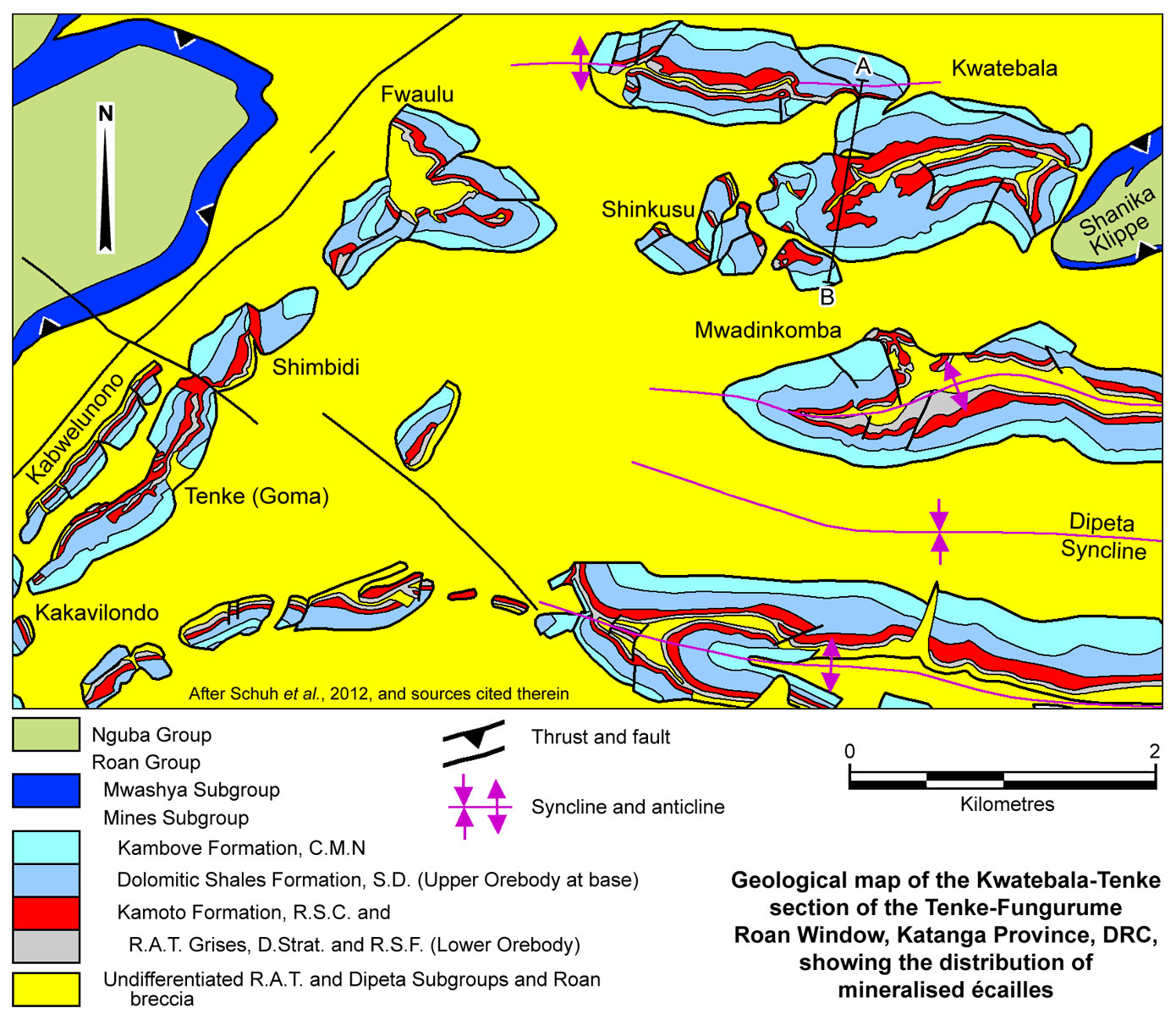
Many of the main deposits are concentrated in a jumble of écailles at the more structurally complex eastern and western extremities of the Dipeta syncline, representing the Fungurume and Tenke clusters of deposits respectively, which are ~15 km apart. Both correspond to areas of more extensive geochemical anomalism, as evidenced by zones of Cu poisoning of the vegetation (copper clearings), except where a leached cap is developed. The axis of the Dipeta syncline has an east-west elongate, 'fish hook' shape in plan, with Fungurume on the eastern extremity of the long side of the 'fish hook'. The Tenke group of deposits are hosted by folded écailles distributed along the hook end, forming the northern limb of the Dipeta Syncline, from the elbow on the western extremity, to the tip of the hook to the NE of that bend.
Three main deposits are recognised in the Tenke group,
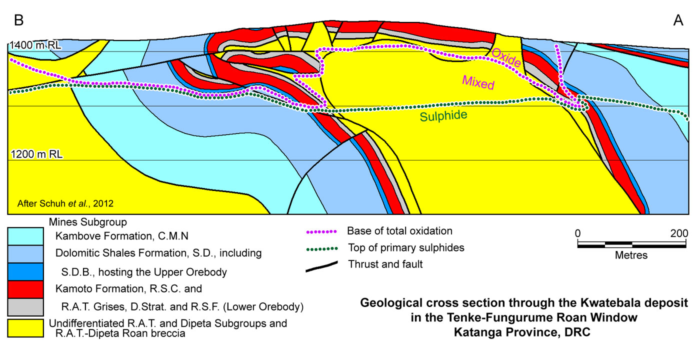
Kwatebala, the largest, located on the point of the 'fish hook', occurring as an anticlinal dome (an isoclinal antiform in the central sections of the deposit, overturned to the south, with a core of diapiric Dipeta breccia), complicated by a small central synform. Mineralisation occurs over a length of ~2.5 km, and is flat to shallowly north dipping over a width of ~1 km in section of the north limb, before it rolls over to dip steeply to the north, parallel to the overturned southern limb. Much of the orebody is above the base of oxidation, which is at 80 to 150 m below the surface, with primary sulphides extending to >300 m on both limbs.
Fwaulu ~ 2 km WSW, of Kwatebala, occurring as a complex, strongly disrupted, flatly north dipping antiform and synform, with a length of ~500 m and depth limit of 300 m.
Goma (also known as Tenke) is in turn made up of a cluster ~2 km to the SW of Fwaulu, extending into the elbow of the 'fish hook'. The Goma mineralisation is distributed over an area of 2.5 x 1 km, to a depth of 1500 m, in a number of écailles, representing a dismembered tight synform, where Shimbidi is on a detached segment of the northern limb, Kabwelunono the main northern limb, which is semicontinuous with other Goma ore on the southern limb, and Kakavilondo a small detached block on the southwestern margin of the synform closure.
At Fungurume, there are eleven deposits, numbered Fungurume I to XI. To the south, shallowly dipping blocks form an open syncline, while in the north, much of the ore occurs as steeply dipping blocks, disrupted by faulting.
In addition to these main areas, other deposits are distributed as follows: Mwadinkomba - on the northern limb of the Dipeta syncline, 1 to 2 km SE of Kwatebala; Kansalawile - on the southern limb of the Dipeta syncline, opposite Mwadinkomba; Mambalima - on the southern limb of the Dipeta syncline, east of Kansalawile; Kazinyanga - on the southern limb of the Dipeta syncline, east of Mambalima and SW of Fungurume; Pumpi North & East - on the western extremities of the Roan window, 10 km WSW of Tenke; Kazinyanga - a small écaille, ~1.5 km south of Mambalima; Shinkusu - between Kwatebala and Mwadinkomba on the extremity of the northern limb of the Dipeta syncline. A large number of other mineralised écailles are also known both to the north and south of the Dipeta syncline.
Estimated total production + 'reserves' in the Tenke-Fungurume District at 2012 (Hitzman et al., 2012, after Woodhead 2012, unpublished):
547 Mt @ 3.5% Cu, 0.27% Co.
Resources estimated by Union Miniere du Haut-Katanga and Gecamines, at a 2% Cu cut-off, following drilling to 1966 (after François and Coussement,1990, unpublished) were:
Kwatebala - 76.286 Mt @ 3.60% Cu, 0.35% Co;
Fwaulu (and Kavifwa) - 14.886 Mt @ 4.16% Cu, 0.14% Co;
Goma/Tenke group
Shimbidi - 3.486 Mt @ 5.88% Cu, 0.41% Co;
Kabwelunono - 24.258 Mt @ 4.35% Cu, 0.18% Co;
Kakavilondo - 0.467 Mt @ 4.37% Cu, 0.32% Co;
Other Goma - 18.362 Mt @ 4.11% Cu, 0.33% Co;
TOTAL Tenke - 137.745 Mt @ 3.92% Cu, 0.30% Co; comprising,
open pit - 78.242 Mt @ 4.30% Cu, 0.34% Co; and
underground - 59.502 Mt @ 3.42% Cu, 0.24% Co;
TOTAL Fungurume - 91.618 Mt @ 5.18% Cu, 0.34% Co; comprising,
open pit - 48.131 Mt @ 5.41% Cu, 0.38% Co; and
underground - 43.487 Mt @ 4.93% Cu, 0.31% Co.
Remaining ore reserves and mineral resources - at December 31, 2011 (Freeport-McMoRan, 2012; Schuh et al., 2012) were:
proved reserves - mill ore - 54 Mt @ 3.26% Cu, 0.36% Co;
probable reserves - mill ore - 87 Mt @ 2.84% Cu, 0.30% Co;
TOTAL proved + probable reserves - mill ore - 141 Mt @ 3.00% Cu, 0.32% Co (Cu - 86.3%; Mo - 75.2% recovery);
inferred resources - mill material - 83 Mt @ 3.44% Cu, 0.29% Co;
inferred resources - leach material - 22 Mt @ 2.81% Cu, 0.29% Co;
TOTAL inferred resources - 105 Mt @ 3.31% Cu, 0.29% Co.
These reserves are distributed as follows (International Mining, March, 2012): Kwatebala - 33.22 Mt @ 2.60% Cu, 0.35% Co; Tenke - including Shimbidi - 30.60 Mt @ 2.88% Cu, 0.36% Co; Fwaulu - 8.84 Mt @ 2.75% Cu, 0.26% Co; Mwadinkomba - 6.12 Mt @ 3.61% Cu, 0.20% Co; Kansalawile - 6.86 Mt @ 3.23% Cu, 0.15% Co; Mambalima - 16.47 Mt @ 3.33% Cu, 0.15% Co; Fungurume - 17.49 Mt @ 4.05% Cu, 0.42% Co; Pumpi North & East - 7.71 Mt @ 3.17% Cu, 0.16% Co; Fungurume VI - 5.98 Mt @ 2.59% Cu, 0.40% Co; Kazinyanga - 1.97 Mt @ 1.47% Cu, 0.37% Co; Kato L3K - 4.39 Mt @ 1.73% Cu, 0.0.60% Co; Shinkusu - 1.54 Mt @ 2.88% Cu, 0.60% Co;
NOTE: "Mineralised material" quoted by Freeport-McMoRan (defined as "delineated by sufficient drilling and/or sampling to support the reported tonnage and average metal grades") is additional to reserves, and is taken to be equivalent to "inferred resources" used in JORC and NI 43-101 standards, and listed as such above.
Annual production in 2011 was 127 400 t Cu and 11 300 t Co (Freeport McMoRan, 2012).
The most recent source geological information used to prepare this decription was dated: 2012.
Record last updated: 13/9/2013
This description is a summary from published sources, the chief of which are listed below.
© Copyright Porter GeoConsultancy Pty Ltd. Unauthorised copying, reproduction, storage or dissemination prohibited.
Kwatebala Goma Fwaulu East
|
|
|
|
|
Fay, I. and Barton, M.D., 2012 - Alteration and ore distribution in the Proterozoic Mines Series, Tenke-Fungurume Cu-Co district, Democratic Republic of Congo: in Mineralium Deposita v.47, pp. 501-519.
|
Hitzman, M.W., Broughton, D., Selley, D., Woodhead, J., Wood, D. and Bull, S., 2012 - The Central African Copperbelt: Diverse Stratigraphic, Structural, and Temporal Settings in the Worlds Largest Sedimentary Copper District: in Hedenquist, J.W., Harris, M. and Camus, F., 2012 Geology and Genesis of Major Copper Deposits and Districts of the World - A tribute to Richard H Sillitoe Society of Economic Geologists Special Publication 16, pp. 487-514.
|
Schuh, W., Leveille, R.A., Fay, I. and North, R., 2012 - Geology of the Tenke-Fungurume Sediment-Hosted Strata-Bound Copper-Cobalt District, Katanga, Democratic Republic of Congo: in Hedenquist, J.W., Harris, M. and Camus, F., 2012 Geology and Genesis of Major Copper Deposits and Districts of the World - A tribute to Richard H Sillitoe, Society of Economic Geologists Special Publication 16, pp. 269-301.
|
|
Porter GeoConsultancy Pty Ltd (PorterGeo) provides access to this database at no charge. It is largely based on scientific papers and reports in the public domain, and was current when the sources consulted were published. While PorterGeo endeavour to ensure the information was accurate at the time of compilation and subsequent updating, PorterGeo, its employees and servants: i). do not warrant, or make any representation regarding the use, or results of the use of the information contained herein as to its correctness, accuracy, currency, or otherwise; and ii). expressly disclaim all liability or responsibility to any person using the information or conclusions contained herein.
|
Top | Search Again | PGC Home | Terms & Conditions
|
|


