|
Frontier, Lufua |
|
|
Dem. Rep. Congo |
| Main commodities:
Cu Co Au
|
|
 |
|
|
 |
Super Porphyry Cu and Au


|
IOCG Deposits - 70 papers
|
All papers now Open Access.
Available as Full Text for direct download or on request. |
|
|
The Frontier sediment hosted copper deposit (previously known as Lufua) is located ~2 km east of the border with Zambia in the Democratic Republic of Congo (DRC), ~30 km southeast of Mufulira (#Location: 12° 43' 43"S, 28° 28' 22"E).
A copper occurrence near Kajiba village was first described by Union Miniere in 1932, where isolated small pits and workings exposed malachite in silicified rock, immediately to the north and south of the stream through the Kajiba Dambo (shallow swamp). Surface assays ranged from <0.5% to 11% Cu total, over what subsequent drilling showed to be a small oxide resource with no depth extension. More extensive trenching and soil geochemistry revealed aerially extensive Cu and Co anomalies in the forest to the north of the surface exposure, which resulted in the discovery of the large copper resource subsequently known as Frontier. Testing by First Quantum Minerals Limited outlined a resource and mining reserve, and production commenced in 2007 (producing 92353 t of Cu and 2.54 t Au in concentrates in 2009). After an unresolved dispute, the DRC government seized the Frontier title in August 2010 and passed it to the state owned Sodimico, who on-sold their share in August 2011 to an undisclosed buyer. In March 2012, the Frontier mining license was granted to Eurasian Natural Resources Corp. Plc (ENRC), who also purchased the mine facilities from First Quantum.
The Frontier deposit is hosted within veined and altered sedimentary rocks of the Katanga Supergroup, and is located on the eastern flank of the Kafue anticline, in the south-eastern section of the Neoproterozoic Lufilian arc (Hitzman et al., 2012).
For details of the regional setting and geological location of Frontier, the Central African/Zambian Copper Belt and the Lufilian Arc, see the separate Zambian Copperbelt and Congolese/Katangan Copperbelt records.
The Frontier deposit is predominantly hosted within shales interpreted to belong to the Mwashya Subgroup, the uppermost unit of the Roan Group, which are stratigraphically overlain by diamictite conglomerates of the Grand Conglomérat (Mwale Formation), the basal unit of the Nguba Group. The shales unconformably overlie a dolostone of the Upper Roan Subgroup, in an area where the Lower Roan Subgroup is condensed, such that the Copperbelt Orebody Member and the broadly stratigraphically equivalent Mufulira ore-bearing sandstones are absent (see the separate Mufulira record for details of the stratigraphy in the district). The Lower Roan Subgroup unconformably overlies schists of the Palaeoproterozoic Lufubu Metamorphic Complex, and is represented by a relatively thin basal conglomerate and overlying quartz sandstone to quartzite, with a combined surface exposed width of 200 to 500 m, and then by a 500 to 0 m exposed width of a southward thinning wedge of Upper Roan Subgroup dolostones. The host Mwashya Subgroup shales form the stratigraphically (and structurally) lowest reduced unit above basement in the local section (Gregory et al., First Quantum, 2005; Hanssen et al., 2006; Hitzman et al., 2012).
The immediate mine section comprises, from the base (after Gregory et al., First Quantum, 2005; Hanssen et al., 2006):
Footwall dolostone, interpreted to belong to the Upper Roan Subgroup, with an upper contact that dips shallowly to the north east, but steepens to the south; 3-D modelling suggested that the top of this dolostone represents a probable unconformity which forms the footwall to the mineralised zone.
However, Kipata (2013) equates at least the upper section of the siltstone-sandstone and lesser conglomerates and associated shales with the arenaceous basal Kamoya Formation (R-4.1) of the Mwashya Subgroup, recognised widely in the DRC.
Altered Mwashya Subgroup shales, which are the primary host to the mineralisation, and to ore in the upper sections of the unit; an interbedded dolomitic unit occurs in the lower half of the subgroup. Kipata (2013) dedscribed this unit as a dolomitic, graphitic and albitic shale, and correlates this part of the section with the Kafubu Formation (R-4.2).
Nguba Group, Grand Conglomérat or Mwale Formation (Ng-1.1) - which, apart from minor mineralisation locally developed in its basal section, is a largely unaltered and largely unmineralised schistose conglomerate, that contains pebble-sized, rounded clasts of sandstone, siltstone, basement schist, quartz and rare dolomite, within a dark, muddy, biotitic to calcareous to dolomitic matrix. The conglomerate occupies two limbs of an overturned, eastward closing antiform, an upper, shallow east-, and a lower west-dipping, which sandwich the overlying dolostones;
Nguba Group, Kakontwe Dolostones (Ng-1.3), that stratigraphically overlie the Grand Conglomérat, separated by the narrow Kaponda Formation (Ng-1.2) shales, and are found between the two fold limbs of conglomerate in the overturned anticline.
The deposit occurs predominantly within shales in the upper portions of the Mwashya Subgroup, and locally within the base of the Nguba Group Grand Conglomérat. It is interpreted to be contained within a shallow SE plunging, NE dipping, overturned anticline, with the thickest mineralisation developed in the nose of the structure. The main ore zone comprises a NW-SE elongated, SE plunging wedge shaped body, opening to the north, ~200 m wide, extending to a depth of as much as 400 m, and is ~2 km long. The upper 100 m is highly weathered, with the main lithologies still recognisable in the saprolite (Gregory et al., First Quantum, 2005; Hanssen et al., 2006; Hitzman et al., 2012; Kipata, 2013).
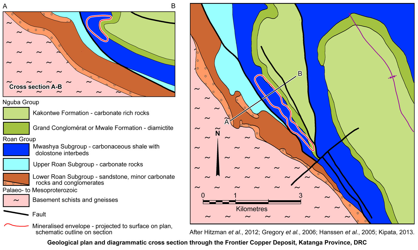
The deposit has been subjected to considerable faulting, which predominantly parallels strike, and is divided into three zones, each corresponding to a tectonically bounded fragment. Overall, the deposit is limited to the SW, with a sharp cut-off, by the major NNW-trending, steeply NE dipping, strike-parallel 'A' Fault zone that in part forms the boundary between the Upper Roan and Mwashya subgroups. This fault downthrows the Upper Roan dolostones significantly to the NW and drilling suggests it the westerly bounding fault of the mineralisation, although additional parallel, but less significant structures are mapped to the SW. A similar, sub-parallel, NE-dipping low angle fault zone repeats the sequence ~1 km to the NE of the deposit where it separates Nguba Group rocks from Mwashya Subgroup shales to the east.
The NE boundary of the ore body is more complex, fractured and faulted when compared the SW boundary, although the ore does not have a faulted boundary in this direction. A series of interpreted parallel faults are found within the orebody zone, labelled A to H. Displacement is not always apparent and some fault zones have little effect on the deposit.
Mineralisation is also truncated and/or offset by NE-SW trending transfer faults. Inversion of the NNW-SSE fault sets, inferred to have originally represented synsedimentary normal faults, were reactivated as thrusts during Lufilian deformation basin inversion, and probably also played a part in the development of the complex recumbent fold that controls the orebody (Gregory et al., First Quantum, 2005; Hanssen et al., 2006; Hitzman et al., 2012).
The deposit is divided into three NNW-SSE trending zones, each corresponding to a tectonically bounded fragment. The ore structure and north-western most ore zone is bounded to the NW by two anastomosing brittle fault sets, the first of which is composed of NW-SE sub-vertical, west dipping, dip-slip normal faults. The second set cuts across, and is orthogonal to the first, and contains alteration minerals such as talc, kaolinite, quartz, Fe- and Mn-oxides. The SE end of the deposit is limited by a steeply dipping fault oriented ENE-WSW, again comprising two fracture sets. The first of this pair generally follows the contact between the Mwashya Subgroup shale and Grand Conglomérat on the overturned NE limb of the fold, whilst the other fracture set is at the contact between the shale and carbonate unit to the west. Both sets are composed of reverse fault planes, which as well as forming the SE limit of ore, also, with a major NE-SW trending set, separate the individual ore zone fragments. Both of these sets are displaced by a large bedding-parallel fault following the Grand Conglomérat contact, a continuation of the structure detailed above at the same contact on the NW margin of the deposit. This large fault has pyrite coated onto fault striae and in reactivated bedding planes (Kipata, 2013).
Unlike at other sites within this part of the Copperbelt, where cleavage is generally absent in Roan Group rocks (François, 2006), it is well developed at Frontier, largely associated with faulting, e.g., in the central part of the deposit between the NW and Central ore zone, where it is associated with a large brittle fault zone. In this zone, the host Mwashya shale unit has been subjected to albite, silica and dolomite alteration. All the stratigraphic layers in this vicinity are highly deformed and cut by S1 cleavage, which is apparently refracted in the more competent layers, obliterating bedding. Riedel fractures are also observed accompanying some of the fracture sets described above, with associated veins that are either chalcopyrite filled or barren in different fracture sets. Tension joints associated with Riedel systems in strongly albitised shale may also contain chalcopyrite as well as bornite, chalcocite, pyrite, carbonates and/or quartz (Kipata, 2013).
The Cu-mineralisation of the deposit, which is principally composed of chalcopyrite, chalcocite, chrysocolla and malachite, is mostly hosted in fractured rocks. Massive pyrite, which is mainly stratiform and lies within the Grand Conglomérat, does not contain Cu-sulphides, other than where cut by carbonate- and quartz-veins at the contact with the Mwashya shale unit. However, in the central part of the deposit, massive pyrite does also occur, but in fractures in a large transverse brittle fault zone, as mentioned above.
The primary orebody comprises a structurally controlled complex network of stockwork to breccia veins that contain an assemblage of dolomite-quartz-chalcopyrite±bornite. Veins range in width from mms to almost half a metre. Thicker veins commonly contain angular clasts of adjacent wall rock. Minor sulphides occur as foliation parallel disseminations in highly deformed and altered shales and diamictite wall rocks adjacent to veins (Hitzman et al., 2012).
The primary sulphidic ore zones are essentially composed of coarse-grained chalcopyrite mineralisation with only trace amounts of chalcocite, digenite, bornite and covellite. Particles of chalcopyrite up to 1000 µm in size are observed, although grains are predominantly 20 to 300 µm. Chalcopyrite predominantly occurs as angular shaped grains interstitially locked between the main silicate and carbonate rock fragments/grains. The principal sulphide gangue mineral is pyrite, which only occurs in trace amounts in the Cu ore zone. Ferroan dolomite, quartz and albite are the main gangue minerals, with lesser quartz, K feldspar, biotite and muscovite in decreasing order (Gregory et al., First Quantum, 2005; Hanssen et al., 2006).
Alteration associated with mineralisation principally comprises sodic metasomatism, with associated silicification and dolomitisation. The sulphide bearing veins are surrounded by a zone with tan- to orange-coloured albite alteration of the wall rocks. This albitisation may extend for cm to metres beyond the margins of individual veins. A replacive fringe of dolomite, some ferroan, is found peripheral to the albitisation, extending for up to several tens of metres from veins, passing outwards into a zone of calcite veining. Both the veins and altered wall rocks were folded, which also produced a weak cleavage which locally contain sulphide minerals. Mineralised rocks are cut by late calcite veins that contain clasts of earlier dolomite-quartz-sulphide veins and albitised wall rocks (Hitzman et al., 2012).
The faults also affect the depth of oxidation, particularly the 'A' fault, within which the weathering profile is significantly deeper. Oxide mineralisation extends from surface to >100 m depth in the vicinity of some of these faults, particularly on the SW margin of the deposit. Elsewhere, the base of almost complete oxidation appears to be at ~40 m below surface, underlain by a mixed oxide-sulphide zone that is 0 to 20 m thick, below which sulphides predominate (from small diagrams in Hanssen et al., 2005).
Pre-mining JORC and NI 43-101 compliant ore reserve and mineral resource figures as at September, 2006, at a 0.35% Cu cut-off (Gregory et al., First Quantum, 2006), were:
Measured + indicated resource - sulphide - 182.068 Mt @ 1.16% Cu;
Indicated resource - oxide - 25.967 Mt @ 1.19% Cu total, 0.65% Cu acid soluble;
Inferred resource - mixed oxide and sulphide - 81.89 Mt @ 1.15% Cu total;
Proved + probable reserve - sulphide - 151.841 Mt @ 1.06% Cu;
JORC compliant mineral resource figures as at 31 December, 2012, (ENRC Annual Report, 2012), were:
Measured + indicated + inferred resource - sulphide - 273.9 Mt @ 1.2% Cu.
Information in this summary has in part been taken from "Gregory et al., December 2006, Frontier Copper Project, Haut Katanga Province, Democratic Republic of Congo; Technical Report" prepared by First Quantum Minerals Ltd, pursuant to Ni 43-101 of the Canadian Securities Administrators -and- "Hanssen et al., June 2005, Frontier Copper Project, Katanga Province, Democratic Republic of Congo; Technical Report" prepared by First Quantum Minerals Ltd, pursuant to Ni 43-101.
The most recent source geological information used to prepare this decription was dated: 2012.
Record last updated: 17/2/2015
This description is a summary from published sources, the chief of which are listed below.
© Copyright Porter GeoConsultancy Pty Ltd. Unauthorised copying, reproduction, storage or dissemination prohibited.
|
|
|
|
|
Hitzman, M.W., Broughton, D., Selley, D., Woodhead, J., Wood, D. and Bull, S., 2012 - The Central African Copperbelt: Diverse Stratigraphic, Structural, and Temporal Settings in the Worlds Largest Sedimentary Copper District: in Hedenquist, J.W., Harris, M. and Camus, F., 2012 Geology and Genesis of Major Copper Deposits and Districts of the World - A tribute to Richard H Sillitoe Society of Economic Geologists Special Publication 16, pp. 487-514.
|
|
Porter GeoConsultancy Pty Ltd (PorterGeo) provides access to this database at no charge. It is largely based on scientific papers and reports in the public domain, and was current when the sources consulted were published. While PorterGeo endeavour to ensure the information was accurate at the time of compilation and subsequent updating, PorterGeo, its employees and servants: i). do not warrant, or make any representation regarding the use, or results of the use of the information contained herein as to its correctness, accuracy, currency, or otherwise; and ii). expressly disclaim all liability or responsibility to any person using the information or conclusions contained herein.
|
Top | Search Again | PGC Home | Terms & Conditions
|
|


