|
Yilgarn Craton - Geology, Structure and Mineralisation |
|
|
Western Australia, WA, Australia |
| Main commodities:
Au Ni Al Fe REE Cu Co Zn Li
|
|
 |
|
|
 |
Super Porphyry Cu and Au


|
IOCG Deposits - 70 papers
|
All papers now Open Access.
Available as Full Text for direct download or on request. |
|
|
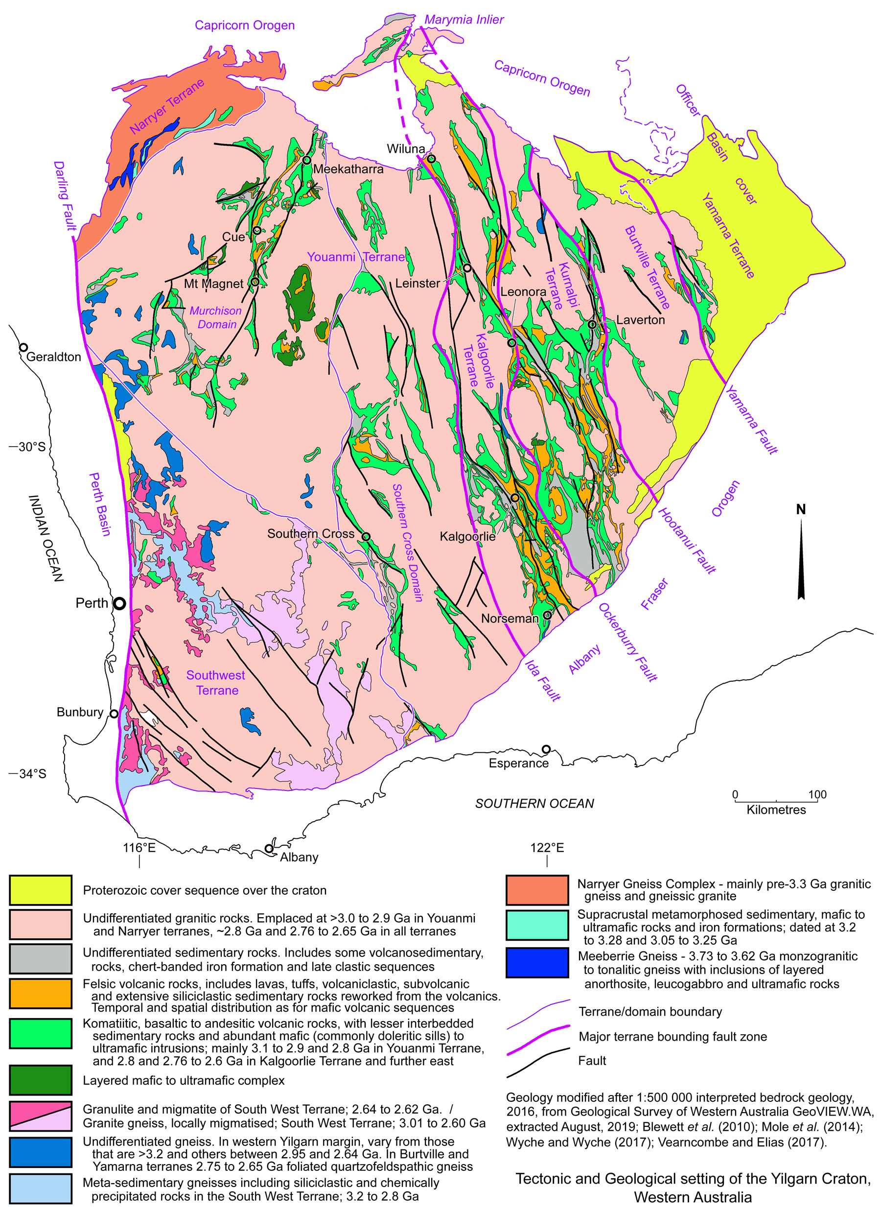
The Archaean Yilgarn Craton in the southern half of Western Australia covers an area of ~650 000 km2. It is bounded to the south and SE by the Mesoproterozoic Albany-Fraser Orogen, to the north by the Palaeoproterozoic Capricorn Orogen, and to the west by the Mesozoic Perth Basin. The latter overlies a sequence of Meso- to Neoproterozoic continental margin sedimentary and volcanic rocks and a Lower Palaeozoic succession. To the east the Yamarna and margins of the Burtville terranes are largely masked by the Neoproterozoic Officer Basin sedimentary succession.
Tectonics and Geology
The core, and largest of the structural elements that make up the Yilgarn craton, is the Youanmi Terrane which forms the bulk of the western half of the craton. This terrane is bounded to the NW by the older Narryer Terrane, and to the SW by the almost comparably sized South West Terrane. Together these three terranes constitute the bulk of the exposed Palaeo- to Mesoarchaean proto-Yilgarn Craton with fault bounded enclaves of younger supracrustal sequences and related intrusions.
The eastern half of the craton is occupied by the Eastern Goldfields Superterrane. The Kalgoorlie Terrane, the westernmost tectonic subdivision of this superterrane, is separated from the Youanmi Terrane to the west by the major Ida Fault Zone. To the east, it is separated from the Kurnalpi Terrane by the Ockerburry Shear Zone (or Mount George and Keith-Kilkenny Shear System). The latter terrane is, in turn, separated from the Burtville Terrane to its east by the Hootanui Shear Zone (or Laverton Shear Zone). The easternmost Yamarna Terrane is bounded on its western margin with the Burtville Terrane by the Yamarna Shear Zone. All of these terranes and their bounding faults are aligned in an overall NNW-SSE trend and are, in turn, divided into constituent fault bounded domains. The greenstone sequences of the Kalgoorlie and Kurnalpi terranes were deposited in a composite rift zone, and are dominated by rocks formed after 2829 Ma, whilst the flanking Youanmi and Burtville terranes represent the proto-Yilgarn craton with rocks that date back to at least 3080 and 2960 Ma respectively. The Yamarna Terrane is characterised by <2720 Ma greenstone magmatism immediately to the east of the proto-Yilgarn Craton.
The late Meso- to Neoarchaean granite-greenstone terranes across the Yilgarn Craton developed during three distinct thermal/magmatic events at ~3.1 to 2.90, ~2.8 and ~2.76 to 2.60 Ga. The supracrustal greenstone belt sequences deposited within these intervals are predominantly composed of bimodal ultramafic-mafic and felsic volcanic rocks in variable proportions, with interbedded volcaniclastic, clastic and chemical sedimentary (cherts and banded iron formations) rocks, although in some belts there are also appreciable sequences of andesitic volcanic and volcaniclastic rocks. The ~2.8 Ga volcanic event is spatially and temporally restricted and is not accompanied by coeval felsic plutonism of the same age, but in some areas, e.g., the Burtville Terrane and Murchison Domain may be continuous with the third magmatic phase.
Based on a large U-Pb and Hf isotopic dataset on zircon, Mole et al., (2019) conclude an original Yilgarn proto-craton was formed from mafic crust as early as the Hadean-Eoarchean at ~4000 Ma and possibly in part as early as 4.46 Ga. This ancient cratonic nucleus, which comprised the Narryer Terrane and the north-central Southern Cross Domain of the Youanmi Terrane, was subsequently rifted, expanded and reworked by successive crustal growth events in the Palaeoarchaean at ~3700 Ma and ~3300 Ma, followed by the three Meso- to Neoarchaean thermal/magmatic events described above, each of which correlate broadly with known komatiite events. Much of the pre-3 Ga tectonic framework has been obliterated by the subsequent widespread mass granitoid development, particularly between ~2.76 to 2.60 Ga.
 Click here to expand
Granites and granitic gneisses cover ~70% of the solid geology of the Eastern Goldfields Superterrane to a depth of at least 15 km, ~80% of which are biotite-bearing monzogranites or granodiorites. Granites account for a lower percentage of the area of the Kalgoorlie and Kurnalpi terranes where greenstones belts are larger, more abundant and thicker. In contrast, only very minor greenstone belts are found internally within the dominantly granitic Burtville Terrane, with the bulk straddling the bounding Hootanui and Yamarna shear zones, continuous with greenstone belts of the adjacent Kurnalpi and Yamarna terranes. Granites account for >80% of the Youanmi Terrane, while very few greenstone belts are mapped in the dominantly granitic Narryer and South West terranes. The granitoids in all of these terranes represent suites emplaced, pre-, syn- and post greenstone deposition.
Similarly, granitoids and granite gneisses cover >80% of the Youanmi Terrane and a similar high proportion of the South West and Narryer terranes, the ages and distribution of which are detailed in the sections on the individual terranes below.
Champion and Sheraton (1997) recognised two major groups (High-Ca and Low-Ca), and three minor groups (High-HFSE, Mafic and Syenitic) of granitoids within the Youanmi Terrane and Eastern Goldfields Superterrane. These may be summarised as follows:
• High-Ca granites, which account for >60% of the granites in the Eastern Goldfields Superterrane, are predominantly granodiorite, granite and trondhjemite and are found both within and external to greenstone belts. These granitoids are felsic (68 to 77 wt.% SiO2) and sodic rocks, largely characterised by Sr-undepleted and Y-depleted signatures. They are largely identical to typical Archean tonalite-trondhjemite-granodiorite (TTG) suites, but lack the tonalitic end-members, and extend to significantly more LILE-rich (Large-Ion Lithophile Elements) compositions than most TTG (Champion and Sheraton, 1997). The chemistry of High-Ca granites are regarded as being consistent with derivation from a plagioclase poor basaltic precursor, at pressures sufficiently high to stabilise significant garnet in the residue following melting, with addition of a crustal component within thickened mafic crust (Champion and Cassidy, 2002, 2007). Two end members of these granites have been differentiated in the Eastern Goldfields Superterrane, based on Y and LILE enrichment, with >70% being the low-Y subgroup, with peak emplacement at ∼2675 Ma. The remainder are younger (peaking at 2660 Ma) and have high-Y and marked LILE enrichment. The latter are interpreted to be the product of shallower melting with greater crustal contamination to entirely crustal melting.
• Low-Ca granites, which are younger, and the second most voluminous group in the EYC, comprising ~20 vol.% of granitoids within the Eastern Goldfields Superterrane. They are chemically distinct from the High-Ca granites, with characteristic high-LILE, strong enrichment in LREE (Light Rare Earth Elements, e.g., Y) and some HFSE (High Field Strength Elements), and compositions consistent with fractional crystallisation (Champion and Sheraton, 1997). They are interpreted to have been derived by partial melting of broadly tonalitic crust, that is, they represent reworking of older High-Ca granitic crust, and display mostly similar TDM model ages to adjacent High-Ca granites. The onset of Low-Ca granite magmatism is therefore taken to mark a significant change in the thermal regime of the crust (Champion and Cassidy, 2007). The emplacement of these granites is diachronous across the Eastern Goldfields Superterrane, with first peak onset in the east at 2650 Ma in the Burtville and Kurnalpi Terranes and subsequently at 2645 Ma in the Kalgoorlie Terrane. Similarly the last peak and waning varies from 2640, 2630 to 2620 Ma in the Burtville, Kurnalpi and Kalgoorlie terranes respectively. The change at ~2.655 Ga to widespread, continued and voluminous Low-Ca dominated-magmatism which continued to ~2.63 Ga across the entire craton indicates a distinct change in the thermal regime of the crust (Blewett and Hitchman, 2004).
• High-HFSE granites, which represent <5% of granites in the Eastern Goldfields Superterrane, and are subvolcanic intrusions, common;ly associated with felsic volcanic rocks of similar composition. They are mostly very felsic with >74% SiO2 and distinct A-type characteristics.
• Mafic granites which are volumetrically minor, representing <5% of granites in the Eastern Goldfields Superterrane. However, their unique geochemistry and proximity to gold mineralisation makes them tectonically and economically significant. They are largely characterised by low and variable silica content (50 to >70% SiO2), moderate to high Ni, Cr, MgO and a range of LILE, LREE and Th contents (Champion and Sheraton, 1997).
• Syenites which are also volumetrically minor, accounting for <5% of the granitoids in the Eastern Goldfields Superterrane. They contain 55 to 75% SiO2 and are characterised by their high Na2O, K2O, and >10% total alkalis, commonly with low MgO, FeO and TiO2 (Libby, 1978; Johnson, 1991; Witt and Davy, 1997; Champion and Sheraton, 1997). Syenite emplacement occurred in two peaks in the in the Eastern Goldfields Superterrane, one at 2665 Ma in the Kalgoorlie, Kurnalpi and Burtville Terranes, and another at 2650 Ma in the Kurnalpi Terrane. All of the metasomatised syenites so far dated were emplaced at ∼2665 Ma in association with Mafic-granites (e.g., Salier et al., 2004). In contrast, the 2650 Ma peak corresponds to the crustally derived Low-Ca granites of the Kurnalpi Terrane and minor ∼2630 to 2640 Ma calc-alkaline lamprophyres (Rock et al., 1990).
The individual terranes within the craton and their supracrustal/greenstone stratigraphy may be summarised as follows:
• Youanmi Terrane - that forms the bulk of the western half of the Yilgarn Craton and covers an area of 900 x 200 to 550 km, is subdivided into the eastern Southern Cross Domain which has a north-south fabric, and a western Murchison Domain with a NW-SE structural grain (e.g., Mole et al., 2013). It contrasts with the Narryer and South West terranes in that it is composed of substantial greenstone belts separated by granite and granitic gneiss. These commenced with abundant 3.01 to 2.93 Ga mafic-ultramafic volcanism and minor quartzites, felsic volcanism and sedimentary rocks. Quartzites at the base of some of these greenstone belts have maximum depositional ages of 3.13 Ga, with detrital zircons ranging up to 4.35 Ga. This phase was followed by a felsic volcanic episode between 2.98 and 2.92 Ga in the north (Hollis et al., 2015). In the central part of the terrane, an extended cycle of mafic-ultramafic-felsic volcanism accompanied by clastic and chemical sedimentation formed greenstone belts with associated granitic magmatism from ~2820 to 2735 Ma. These overlapped large mafic-ultramafic layered intrusions between ~2820 and 2710 Ma (Ivanic et al., 2010). The last volcanism within the terrane involved mafic and felsic volcanic and clastic sedimentary rocks as well as high Ca tonalite-trondhjemite-granodiorite (TTG) rocks between 2735 and 2720 Ma (Kranendonk et al., 2013). In more detail, the sequences within the two domains comprise (after Mole et al., 2013):
Murchison Domain
i). Golden Grove Group - a 2960 to 2930 Ma sequence that includes komatiite, high-Mg to tholeiitic basalt, mafic volcanic rocks with interlayered BIF, felsic volcanic, volcaniclastic and epiclastic sedimentary rocks;
ii). Norie Group - a 2825 to 2800 Ma succession of felsic volcanic rocks, komatiitic-basalt, interbedded andesite to rhyolite, coarse clastic sedimentary rocks and felsic volcaniclastics;
iii). Windimurra and Lady Alma layered mafic-ultramafic intrusions dated at 2810 to 2800 Ma. The former, which is ~ 150 km south of Meekatharra, covers an area of ~2500 km2 (85 x 37 km, elongated north-south) and is up to 11 km thick. The Lady Alma Complex is ~30 km SSE of Meekatharra;
iv). Polelle Group, 2800 to 2735 Ma tholeiitic and komatiitic-basalt, komatiite with thin interflow felsic volcaniclastic rocks and andesitic volcanic and volcaniclastic rocks;
v). Glen Group, 2735 to 2710 Ma felsic volcanic rocks, komatiitic-basalt with interbedded andesite to rhyolite, followed by coarse clastic sedimentary and felsic volcaniclastic rocks;
vi). Yalgowra Suite and Gnanagooragoo Igneous Complex composed of 2735 to 2710 Ma aged thick, layered mafic–ultramafic sills, made up of thick gabbro with basal peridotite and pyroxenite with leuco-gabbro-anorthosite tops; The Gnanagooragoo Complex, ~100 km SW of Meekatharra, comprises a funnel-shaped, strongly layered ultramafic lower section, a wide, thick, up to 15 km long gabbroic middle section and a wide, up to 70 km long upper zone, which consists of a voluminous series of stacked dolerite sills that are up to 5 km thick. The dolerites contain numerous screens of banded iron-formation and some felsic rocks.
Southern Cross Domain
i). Basal quartzites - quartzitic metasedimentary rocks that were deposited in the Marda, Illara and Maynard Hills greenstone belts after 3100 Ma, but contain detrital zircons as old as 4400 Ma;
ii). Lower Greenstones - composed of ~3000 to 2900 Ma komatiite, high-Mg and tholeiitic basalt in the Marda, Southern Cross, Forrestania, Lake Johnston and Ravensthorpe greenstone belts, but also including felsic volcanic rocks in the Lake Johnston and Ravensthorpe belts, with BIF and chert;
iii). Midde Greenstones - dated at ~2800 Ma, composed of gabbro, felsic volcanic rocks and an intrusive felsic porphyry in the Southern Cross, Marda and Forrestania greenstone belts with a possible younger volcanosedimentary package;
iv). Marda Complex - a 2730 Ma andesite to rhyolite volcanic complex;
v). Clastic package - a suite of siliciclastic sedimentary rock in the Marda and Southern Cross belts that is younger than 2720 Ma.
Mafic–ultramafic rocks occurring in structurally dismembered layered intrusions comprise ~40% by volume of greenstones in the Murchison Domain. These are subdivided into five main temporal groupings (after Ivanic et al., 2015) distributed over an ~300 km diameter area, with Meekatharra being towards its northern perimeter, as follows: i). the most extensive ~2810 Ma Meeline Suite, which includes the large Windimurra Igneous Complex and lies within the southeastern half of the area; ii). the 2800±6 Ma Boodanoo Suite, which includes the Narndee Igneous Complex on the southern margin of the Windimurra Complex; iii). the 2792±5 Ma Little Gap Suite, which is limited in extent and occurs to the north and centre of the area; iv). the ~2750 Ma Gnanagooragoo Igneous Complex in the NW; and v). the 2735 to 2710 Ma Yalgowra Suite of layered gabbroic sills that are distributed over the northwestern half of the area.
These intrusions are typically layered, tabular bodies of gabbroic rock (including gabbro, leucogabbro, gabbronorite) with ultramafic basal units which, in places, are >6 km thick. Individual lobes and sills cover areas of as much as 2500 km2, although these are the remnants after dismemberment by younger deformation. Discordant features and geochemical fractionation trends in the Windimurra and Narndee complexes indicate multiple pulses of magma that produced several megacyclic units, each ~200 m thick. These suites are anhydrous except for the Boodanoo Suite, which contains a large volume of hornblende gabbro. They host significant vanadium, ilmenite and magnetite, and at least minor Ni-Cu-PGE mineralisation (Ivanic et al., 2015). All suites are contemporaneous with packages of high-Mg tholeiitic lavas and/or felsic volcanic rocks in the adjacent greenstone belts (Ivanic et al., 2015).
Granitoids and granite gneisses cover >80% of the terrane, with High-Ca granitoids accounting for the bulk of these intrusions emplaced in three episodes; i). >3.0 to 2.9 Ga, ii). ~2.81 Ga, iii). ~2.76 to 2.68 Ga, but mostly between 2.73 and 2.68 Ga.
The volumetrically lesser Low-Ca granitoids, which are reworked earlier High-Ca granites, were formed between 2.65 and 2.6 Ga; predominantly from 2.65 to 2.63 Ga, with some possibly as old as 2.685 Ga.
The volumetrically less common High-HFSE and Mafic granites were both emplaced in the intervals 3.01 to 2.92 Ga; ~2.81 Ga; 2.76 Ga to 2.45 and younger to 2.10 Ga. No significant syenites are recorded in the Youanmi Terrane.
• Narryer Terrane - The older, but much smaller 50 x 350 km, ENE-WSW aligned Narryer Terrane is dominated by the Narryer Gneiss Complex composed of granitic gneiss and granite with much lesser granodiorite and muscovite granite. The terrane also includes mafic intrusive rocks, granites and granite gneisses dated at 3730 to 3300 Ma, with detrital zircons in conglomerates and quartzites and inherited zircons in igneous rocks that date back to ~4.4 Ga (Wilde et al., 2001).
The complex has been subdivided into the Meeberrie and Dugel gneisses (Myers and Williams 1985). The older of these, the Meeberrie Gneiss is composed of a complex mixture of lithological associations, mainly derived from monzogranites that have ages of 3.68 to 3.60 Ga (U-Pb zircon; Myers and Williams, 1985; Kinny et al., 1988; Myers 1988; Myers et al., 1990; Nutman et al., 1991, 1993). The oldest rocks of the Meeberrie Gneiss have maximum zircon U-Pb age of 3.73 Ga (Nutman et al. 1991; Kinny and Nutman 1996). The Meeberrie gneiss was intruded by 3.38 to 3.35 Ga monzo- or syenogranitic magmas which were the protoliths of the Dugel Gneiss (Myers and Williams 1985; Kinny et al., 1988; Myers 1988; Nutman et al., 1991, 1993; Pidgeon and Wilde 1998). Both the Meeberrie and Dugel gneisses contain inclusions of 3.73 Ga meta-anorthosites, -gabbros and -ultramafic rocks, known as the Manfred Complex (Myers and Williams 1985; Kinny et al., 1988; Myers 1988). Tonalitic to granitic magmas, protoliths of the Eurada Gneiss, were emplaced into the southern sections of the Narryer Gneiss Complex at 3.49 to 3.44 Ga Nutman et al., 1991). The Meeberrie, Eurada and Dugel gneisses contain 3.30 to 3.28 Ga zircons that are interpreted to reflect contact metamorphism during granite emplacement (Kinny et al., 1988; Nutman et al., 1991; Kinny and Nutman 1996). Younger sheets of syn- to post-kinematic granite and gabbro were intruded at 2.75 to 2.60 Ga in both the Murchison Domain and Narryer Terrane, accompanied by widespread greenschist to granulite facies metamorphism (Myers et al., 1990; Kinny et al., 1990; Nutman et al., 1991, 1993; Pidgeon and Wilde 1998). This thermotectonic deformation and recrystallisation event is regarded to have been responsible for the main gneissic fabric (Myers et al., 1990).
The terrane includes ~10% metamorphosed supracrustal greenstone inliers containing clastic sedimentary rocks and iron formations dated at between 3.2 to 3.3 Ga (Iizuka et al., 2010) and others at between ~3.05 and 2.65 Ga. The most extensive of these inliers are the Narryer and Jack Hills supracrustal belts. The Narryer Supracrustal Belt is dominantly composed of: i). quartzite with variable garnet, cordierite, sillimanite, plagioclase, pyroxene and amphibole; ii). quartz-pebble meta-conglomerate; and iii). polymictic meta-conglomerate with pebbles of quartz, BIF and paragneiss. The sedimentary rocks underwent upper amphibolite to granulite facies metamorphism, indicated by an assemblage of sillimanite-cordierite-garnet in quartzite. They were also subjected at least two deformation events (Williams and Myers 1987). However, while being recrystallised during metamorphism (Myers et al., 1990; Nutman et al., 1991), primary sedimentary textures (e.g., cross- and graded bedding) are well preserved particularly in the southern section of the belt, implying a fluviatile, braided stream depositional regime (Williams and Myers 1987). Detrital zircons from units within the inlier range from as old as 4.28 Ga, but are distributed in populations with ages and chemical characteristics consistent with derivation from the protolith of orthogneisses within the neighbouring Narryer Gneiss Complex. Deposition is constrained to younger than 3.28 Ga, the crystallisation age of the youngest detrital zircon. Dating of metamorphic monazite from the silimanite-cordierite-garnet metamorphic mineral assemblage of sedimentary rocks from the Narryer Supracrustal Belt reveals two peaks (Iizuka et al., 2015). The dominant of these coincides with a 2.7 Ga granulite-facies metamorphic event derived from K-Ar ages of hornblende in amphibolites within the belt (Kinny et al., 1990) and by the U-Pb ages of overgrowth on detrital zircons (Kinny et al., 1990; Trail et al., 2007). However, Iizuka et al. (2015) show there is an earlier peak at ~3.3 to 3.2 corresponding to an earlier tectono-thermal event, and limiting the age of deposition of the Narryer Supracrustal Belt to 3.28 to 3.2 Ga.
The narrow, ~70 km long Jack Hills Supracrustal Belt is ~50 km further to the ENE, and is in fault contact with neighboring granitoids, some of which are strongly gneissose (Myers et al., 1990). Four lithological associations have been mapped: i). BIF and cherts, accompanied by mafic schists (amphibolite) and ultra-mafic intrusions; ii). pelitic and semi-pelitic schists with mafic schists; iii). a more restricted association of mature clastic meta-sedimentary rocks, including interbedded pebble conglomerates, sandstones, quartzite and siltstone (including quartz-mica and andalusite schist) suggestive of alluvial-fan deposition; and iv). Proterozoic meta-sedimentary rocks.
There is no evidence of Archaean granitoid intrusion and tectonothermal metamorphism within the Jack Hills inlier. The first two of the four lithological associations are only being intruded by 2654± and 2643±7 Ma monzogranites (zircon; U-Pb ages; Pidgeon and Wilde 1998), while the youngest detrital zircons are dated at 3064±17 Ma (Nelson 2001). The BIF at Jack Hills contains a significant resource of quartz-magnetite mineralisation that forms the Jack Hills iron deposit.
The main fabric of the Narryer Terrane trends ENE-WSW, in contrasts with the NW-SE structural grain of the contiguous Murchison Domain to the south.
• South West Terrane. The much more extensive triangular, ~150 000 km2 South West Terrane was amalgamated onto the SW margin the Youanmi Terrane at ~2.65 Ga (Cassidy et al., 2006). It has an overall NW-SE tectonic fabric, and is characterised by a paucity of preserved greenstone belts. It is predominantly composed of granitic rocks, the majority of which are divided into five main overlapping suites based on geochemical characteristics, emplaced between 2.75 and 2.62 Ga with a volumetrically smaller group dated at 2.85 to 2.70 Ga (Qiu and McNaughton, 1999). The bulk of the granitic rocks are younger than 2.69 Ga, and mainly comprise monzogranite, granodiorite and alkali feldspar granites. The younger granitoids were emplaced between 2648 and 2626 Ma, with continued cooling and Pb loss from zircons, from 2628 to 2616 Ma. Post-tectonic, ~2580 Ma granitoids also occur towards the eastern margin of the terrane (Wilde et al., 1996; Nemchin and Pidgeon, 1997).
Extensive granulite facies metamorphism with associated migmatite and charnockitic granites were formed between ~2.64 and 2.62 Ga producing a series of high-grade metamorphic domains. The most significant are the Balingup and Jimperding metamorphic belts in the SW and NW of the Terrane respectively. An extensive, but irregular, corridor of granitic gneiss and migmatites, with associated small layered mafic intrusions, continues from the Jimperding belt in the NW towards the SE and the southern edge of the Yilgarn Craton. These metamorphic domains appear to be related to broad zones of shallow, west-vergent, thrusting (Wilde et al., 1996).
Supracrustal sequences are mainly represented by 3.2 to 2.8 Ga quartz-feldspar-biotite gneisses that are predominantly after siliciclastic and chemically-precipitated metasedimentary protoliths and orthoquartzites (Cassidy et al., 2006). These sequences contain detrital zircons that are >3.73 to 3.17 Ga, and generally predate the granitoids. They are mostly preserved within extensive zones of granulites, migmatites and granite gneisses, particularly within the cores of the Balingup and Jimperding metamorphic belts.
Preserved greenstone belts are limited in extent and number, and have a range of ages. In the west, the Wongan Hills greenstone belt to the north has been dated at ~3.01 to 2.82 Ga, similar to the supracrustal metasedimentary gneisses, and comprises mafic and felsic volcanic rocks, chert, BIF and small ultramafic intrusions. The Morangup and Saddleback greenstone belts in the central west and lower west of the terrane respectively, are younger, composed of basaltic, intermediate and lesser felsic volcanic rocks, ultramafic dykes and granitoids emplaced between 2714 and 2612 Ma. Both are partially fringed by granulites and older metasedimentary gneisses. The latter are interpreted to represent older sialic basement onto which the greenstone belt rocks have been emplaced. Both are otherwise truncated by younger granitoids (Wilde et al., 1996).
• Kalgoorlie Terrane - is the westernmost structural element of the Eastern Goldfields Superterrane, and occurs on the eastern margin of the Youanmi Terrane, across the east-dipping Mount Ida Fault. It occupies a NNW-SSE trending strip that is exposed over a width of ~50 to 120 km and length of ~800 km, bounded to the east by the Ockerburry Fault. The Kalgoorlie Terrane was initiated by an ~2810 Ma rifting event which produced the basin into which the younger sequences of the terrane were deposited. This rifting is interpreted to have coincided with a plume event, or plume initiated extension and voluminous mafic ultramafic volcanism that produced the widespread relatively juvenile crust and greenstone development in the Kalgoorlie and adjacent Kurnalpi terranes. The Kalgoorlie Terrane is divided into a collage of six structural domains that contain metamorphosed, dismembered and thrust repeated, but correlatable 2.73 to 2.65 Ga rock sequences that comprise three unconformity-bound lithostratigraphic sequences as follows. A detailed internal stratigraphy has only been established within the southern half of the Kalgoorlie Terrane as shown below, from the base:
i). Kambalda Sequence, the lowermost, dominantly volcanic succession, which in the southern Kalgoorlie Terrane comprises a 1500 to 4500 m thick lower mafic-ultramafic suite consisting of the Lunnon Basalt, Kambalda Komatiite (divided into the lower Silver Lake Peridotite and overlying Tripod Hill Komatiite), Devon Consols Basalt (a high-MgO basalt), Kapai Slate (<10 m thick) and Paringa Basalt, with numerous interbedded interflow sedimentary rocks including the Oroya Shale that overlies the Paringa Basalt. These rocks, which were deposited from 2715 to 2690 Ma are predominantly subaqueous and are intruded by numerous dolerite sills. Elsewhere along the trend of the Terrane essentially the same succession has other stratigraphic names, e.g., at Agnew in the northern section, a thicker (3.1 to 7 km) sequence whose early members are older than to those to the south, commences with the pre-2720 Ma Butchers Well Basalt, Donegal Komatiite, Hicklers Bore Basalt, Songvang Basalt (a komatiitic basalt), Never-can-tell Basalt (equivalent to the Lunnon Basalt), Agnew Komatiite (equivalent to the Silver Lake Peridotite), Burrell Well Basalt (a komatiitic basalt equivalent to the Tripod Hill Komatiite), Redeemer Basalt (a komatiitic basalt equivalent to the Devon Consols Basalt), and White Hope Basalt (equivalent to the Paringa Basalt). The komatiites in the southern Kalgoorlie Terrane are olivine-rich compound units on a mafic substrate. In the northern part of the terrane, from Agnew to Wiluna, the equivalent komatiitic rocks are olivine-rich, thick dunitic komatiite units deposited onto, or coeval with, felsic volcanic and sedimentary rocks. These differ from the ultramafic rocks in the Youanmi Terrane, in that they are younger, but also have a different chemical character. The older Youanmi komatiites (e.g., in the Forrestania-Lake Johnson-Ravensthorpe Greenstone Belt) are moderately olivine-rich compound komatiite units and dunite bodies on a BIF or felsic substrate (Vearncombe and Elias, 2017), and include Al-depleted, and Al-undepleted and Ti-enriched varieties, whereas those in the Kalgoorlie Terrane are all Al-undepleted (Barnes et al., 2007). In the southern part of the terrane, the Kambalda Sequence is unconformably overlain by the,
ii). Kalgoorlie Sequence, which was deposited between 2690 and 2660 Ma (Blewett et al., 2010). In the southern part of the terrane it is >3000 m thick, and is composed of four units, each separated by an unconformity, the Early and Late Black Flag groups between 2690 and 2670 Ma and the 2670 to 2658 Ma Early and Late Merougil Group.
The Early Black Flag Group consists of massive graded to moderately stratified feldspar-rich sandstone, siltstone, felsic cobble-conglomerate, volcanic rocks and associated polymict volcaniclastic and epiclastic rocks, and rare mudstone. The volcanic rocks are mostly tonalite-trondhjemite-dacite with subordinate rhyolite and andesite. Rapidly reworked feldspar-rich pyroclastic debris predominates towards the base and intermediate to felsic volcanic and volcaniclastic rocks in the upper sections. The Late Black Flag Group consists of coarse mafic conglomerate facies, quartzo-feldspathic sandstone, with interbedded volcanic rocks as well as mudstone-siltstone (Oxenburgh et al., 2017; Squire et al., 2010).
Regionally, sandstones within the Kalgoorlie Sequence/Black Flag groups have detrital zircons younger than 2690 Ma (Kositcin et al., 2008) suggesting derivation from local internal volcanic rocks. This is supported by the observation that detritus in both Black Flag groups closely match the nearby and/or stratigraphically underlying successions, thus suggesting relatively local provenance (Squire et al., 2010). The Black Flag groups are intruded by subvolcanic rhyolite and dacite sills and dykes inferred to be feeders to the volcanic centres of the Kalgoorlie Sequence.
Rocks of the Kambalda and lower Kalgoorlie sequences are also cut by dolerite sills up to 2 km thick, e.g., the 650 to 750 m thick, 2680±9 Ma Golden Mile Dolerite sill at Kalgoorlie which persists along strike for ~25 km (Travis et al., 1971; Witt 1995). This sill, which was emplaced during deposition of the Lower Black Flag Group, is a differentiated tholeiitic dolerite intruded along the unconformable contact between the Paringa Basalt/Oroya Shale and Early Black Flag Group, marking a density contrast between mafic and felsic country rock. It has well-developed 10 to 20 m thick chilled margins, and has been fractionally differentiated into 10 lithologically distinct units from bottom to top. Other such doleritic sills are found at different levels within the same sequences e.g., the 350 m thick, 2692±5 Ma Williamstown Dolerite intruded during deposition od the late Kambalda Sequence and emplaced between the Kapai Slate and Paringa Basalt at Kalgoorlie, and the Condenser and Junction, and the Defiance dolerites at the same stratigraphic levels and ages at St. Ives. The Upper Black Flag Group unconformably overlies the Golden Mile Dolerite and includes clasts sourced from the sill in its basal sections.
The Merougil Group unconformably overlies the Black Flag Group and commences with deposition of a >1630 m thick suite of coarse-grained quartz-rich sandstone with abundant conglomerate beds towards the base. On the basis of the texture of the constituent grains, these are interpreted to represent rapidly reworked quartz-rich pyroclastic deposits dominated by a single population of 2670 to 2660 Ma detrital-zircons. These reflect the peak of high-Ca granite magmatism in the Yilgarn Craton, suggesting the sandstones represent reworked volcanic rocks related to these intrusions. These rocks are the lower Merougil Group. The subsequent, unconformably overlying late Merougil Group is a thick pile of predominantly coarse felsic conglomerate with abundant volcanic quartz. The detrital zircons in these successions have a broad spread of age, although the principal sub-population has an age ~2665 Ma suggesting they may represent reworking of the lower Merougil Group and exhumation of predominantly felsic basement units of the granite domes that developed during this period.
NOTE: The Merougil Group is included in the Late Clastic Basin by some authors (e.g., Blewett et al., 2010), while Squire et al. (2010) and Vielreicher et al. (2016) appear to have grouped it into the Kalgoorlie Sequence on the basis of it representing a repeated volcanosedimentary cycle similar to the Black Flag Group, whilst the succeeding Kurrawang Formation is dominantly a clastic sequence.
iii). Late Clastic Basin - Kurrawang Formation. The Kurrawang Formation, deposited between 2658 and 2655 Ma, disconformably overlying the Merougil Group and reflecting widespread (and deep) exhumation of ancient Archaean crust. It comprises coarse, poorly sorted polymictic conglomerate, grading upward into fine-grained sandstone and siltstone. The basal section is dominated by up to 40% clasts of BIF, with common volcanic and lesser plutonic quartz and felsic lithic fragments with detrital zircons aged up to 3500 Ma towards the top that indicate a distal provenance, probably in the Youanmi Terrane (Squire et al., 2010; Krapez et al., 2008).
• Kurnalpi Terrane - which is found immediately to the east of the Kalgoorlie Terrane, across the east-dipping Ockerburry Fault and is composed of 7 fault bounded internal domains. This terrane is interpreted to be part of the same rift complex as the Kalgoorlie Terrane, but contains a differing suite of supracrustal rocks. It varies from 50 to 150 km in width and is sporadically exposed over a NNW-SSE trending strike length of ~650 km, bounded to the east by the older Burtville Terrane, which has similarities to the Youanmi Terrane and appears to mark the eastern margin of the Kalgoorlie-Kurnalpi rift. It has been suggested that attenuated Youanmi Terrane crust forms the basement to the Kalgoorlie and Kurnalpi terrane supracrustal rocks. The similarity of crystallisation ages and juvenile Nd signatures of the oldest rocks preserved in these terranes and those of the granites and greenstones of the Youanmi Terrane, together with the inherited zircon record from granitic rocks in the younger terranes, although not proof, are consistent with this hypothesis (Czarnota et al., 2010). The sequence in the terrane is composed of the following sequences:
i). Laverton Sequence, possibly deposited in a series of parallel rifted fragments separated by horsts, and mostly composed of ~2800 Ma high-Ti tholeiitic basalt, komatiite, komatiitic basalt and banded iron formation with minor quartz-bearing clastic sedimentary rocks including turbidites, and intruded by felsic porphyries. The sequence commences with basal units of BIF and ultramafic successions, overlain by basalt that has been intruded by gabbro and dolerite dykes, followed by additional complex successions of BIF, basalt and sedimentary rocks. This sequence may reflect the initial stages of the opening of the rift Kalgoorlie-Kurnalpi rift basin. This period of mafic-ultramafic magmatism appears to precede the similar lithologies of the Kambalda Sequence of the Kalgoorlie Terrane to the west.
ii). Kurnalpi Sequence which occupies the majority of the terrane and comprises ~2715 to 2704 Ma calc-alkaline intermediate volcanic and volcaniclastic sedimentary rocks, dominated by andesitic complexes with associated quartz-poor volcaniclastic sedimentary rocks and mafic intrusive rocks (Barley et al., 2008). These rocks grade up into quartz-bearing sandy turbiditic rocks and conglomerate with clasts of dacite and andesite (Standing, 2008). This sequence contrasts with the coeval ~2715 to 2690 Ma Kambalda Sequence of the Kalgoorlie Terrane which is dominated by mafic–ultramafic rocks and has similar lithofacies to the Kalgoorlie Sequence of the Kalgoorlie Terrane. The Kurnalpi Sequence is conformably overlain by the
iii). Minerie Sequence which comprises a 2698 Ma deep pillow basalt, dolerite and high-magnesian basalt to komatiites (termed the Murrin Murrin komatiite) with minor sedimentary rocks (Kositcin et al., 2008; Barley et al., 2008).
iv). ~2695 to 2680 Ma Sequence restricted to the Gindalbie Domain on the western margin of the terrane, unconformably overlying the Kurnalpi and Minerie sequences forming a linear belt of bimodal rhyolite-basalt and felsic calc-alkaline complexes, including contemporaneous A-type granite intrusions (Swager, 1995, 1997; Brown et al., 2001; Barley et al., 2008).
v). Basinal Sequence a suite of siliciclastic rocks deposited in late synorogenic basins, that in the Laverton area are predominantly turbidites, but also include carbonaceous shale, sandstone, conglomerate, chert and magnetic shales, and include the polymictic Wallaby Conglomerate SW of Laverton. These successions are dated at younger than 2673±5 Ma (Krapez and Barley, 2008; Kositcin et al., 2008; Standing, 2008). The latter is intruded by temporally and chemically distinct suites of felsic (2664±3 Ma) to mafic (2665±4 Ma) intrusive rocks (Standing, 2008). This sequence, although slightly diachronous across the superterrane is equivalent to the Merougil Sequence or Kurrawang Formation of the Kalgoorlie Terrane.
• Burtville Terrane, which marks the eastern margin of the Kalgoorlie-Kurnalpi rift basin across the east dipping Hootanui Fault Zone. This terrane is ~150 km wide and has a NNW-SSE extent of ~400 km, separated from the Yamarna to the east by the Yamarna Shear Zone. Correlation of lithologies and ages of magmatism in the eastern and western Yilgarn Craton indicates that the Burtville Terrane has affinities with the Youanmi Terrane that forms the nucleus of the craton. The Burtville and Youanmi terranes shared a common history from ~2970 until ~2720 Ma when deposition of the Kambalda and Kurnalpi sequences became established in the Kalgoorlie and Kurnapli terranes respectively (Pawley et al., 2012). Magmatism occurred during the following intervals:
i). The oldest recognised supracrustal greenstone magmatism occurred between ~2970 and 2910 Ma, as well as 2932±3 Ma metagranite (Wingate et al., 2011) and 2939±6 Ma granodioritic orthogneiss (Pawley et al., 2012).
ii). Towards the western margin of the terrane, a mafic–ultramafic succession is overlain by intermediate to felsic andesitic volcanic to felsic volcaniclastic rocks that have been dated at 2805±5 Ma, and are intruded by minor felsic porphyries dated at 2804±5 Ma (Kositcin et al., 2008). Another greenstone belt package has been intruded by the 2812±5 Ma Swincer Dolerite (Wingate et al., 2011).
iii). A cycle from 2775 to 2735 Ma that occurred in three pulses. The first was between ~2775 and 2760 Ma, producing both felsic volcanic and volcaniclastic rocks overlying ultramafic, mafic volcanic and clastic sedimentary rocks, and minor banded iron-formation within greenstone belts on the eastern margin of the terrane. It also formed the protolith to gneisses with ages ranging from ~2770 to 2765 Ma (Fletcher et al., 2001; Wingate et al., 2010c). The second magmatic cycle was at ~2755 Ma when an igneous complex intruded mafic volcanic rocks of greenstone belts on the eastern margin of the terrane (Wingate et al., 2011). Further west on the western margin of the terrane, a 2755±5 Ma hornblende plagiogranite, interpreted to be the fractionated felsic component of a layered gabbro (Fletcher et al., 2001) intruded metamorphosed mafic and ultramafic volcanic rocks. The final pulse of magmatism occurred between ~2740 and 2735 Ma and included both mafic and felsic magmatism on the eastern margin of the terrane within the greenstones straddling the Yamarna Shear Zone (Pawley et al., 2012).
iv). A cycle from 2715 to 2630 Ma - which is largely a time equivalent of the Kurnalpi and Kambalda-Kalgoorlie sequences of the Kurnalpi and Kalgoorlie terranes respectively. This cycle is largely confined to felsic gneisses and granitoids in the Burtville Terrane (Pawley et al., 2012).
• Yamarna Terrane, which is separated from the Burtville Terrane by the broad, east dipping Yamarna Shear Zone which follows and bisects the Yamarna-Mount Gill greenstone belt (Pawley et al., 2012). Greenstone belts within this terrane are composed of mafic and felsic volcanic rocks with interbedded clastic sedimentary and minor ultramafic rocks. Felsic volcanics rocks in a greenstone belt have been dated at 2682±5 and 2699±5 Ma. Orthogneisses distal to greenstones are dated at 2711±6 Ma, with 2751 to 2815 Ma xenocrysts.
Granitoids cover >70% of the Eastern Goldfields Superterrane, with High-Ca granitoids accounting for >60% of these intrusions. Minor remnants of 2800 Ma High-Ca granitoids are preserved within the superterrane, with the rest dated at between 2740 and 2650 Ma, the majority of which are 2685 to 2655 Ma, diachronously distributed, younging westward from the Burtville to Kalgoorlie terranes.
The volumetrically lesser Low-Ca granitoids, which are reworked earlier High-Ca granites, were all formed between 2655 and 2630 Ma, subsequent to the main greenstone belt magmatism and the clastic basin deposition in the superterrane.
The volumetrically less common High-HFSE and Mafic granites were both emplaced in the intervals from earlier than 2720 to ~2650 Ma. Syenites were emplaced between 2655 and 2645 Ma.
Structure.
All of the rocks of the Eastern Goldfields Superterrane have been subjected to the same post 2720 Ma structural history, comprising the D1 to D6 of Blewett and Czarnota (2010) as follows:
• Pre-D1 deformation - slivers of granite gneisses and other greenstone stratigraphy older than 2720 Ma are preserved largely on the margins of some of the larger granite domes in the Kalgoorlie and Kurnalpi Terranes (Cassidy, 2006) and in greenstone belts in the western Burtville Terrane (Cassidy, 2006; Cassidy et al., 2006; Pawley et al., 2009). Insufficient exposure is available to elucidate a structural history.
• D1 Extension between 2720 and 2670 Ma corresponds to the major extensional event, with intermittent compression, that accompanied the major crustal growth of that interval. This event commenced with rifting within the eastern margin of the Youanmi Terrane, and development of the NNW-SSE aligned Kalgoorlie-Kurnalpi Rift basin then focused the deposition and eruption of the greenstone sequences of the Kalgoorlie and Kurnalpi terranes from ~2720 Ma. Extension dominated through to the onset of the first significant contraction at around 2670 Ma. Relicts of older Youanmi Terrane affinity basement are preserved as slivers and blocks of >2810 Ma granites, particularly in the Burtville Terrane (Pawley et al., 2009) and as exhumed slices of higher pressure rocks in the footwall of D3 core complexes (Cassidy et al., 2002). Early isoclinal folds attributed to D1 have been interpreted by Blewett et al. (2004) as recumbent lower-plate folds developed during vertical flattening and extension (e.g., Harris et al., 2002). Changes across linear NNW trending structures are interpreted to reflect extensional tectonics and growth faulting during basin development. Blewett et al. (2010) indicate many of these growth faults are found within the vicinity of major gold deposits of the region, such as the Carey Shear at Sunrise Dam (Henson et al., 2010), the Golden Mile Fault at Kalgoorlie (Gautier et al., 2007), and the Playa Shear at St Ives (Connors et al., 2003; Miller et al., 2010). Many have been reactivated to become reverse faults during later inversion.
• D2 ENE–WSW directed contraction - which started at around 2670 Ma in the east (Burtville Terrane) and around 2665 Ma to the west in the Kalgoorlie Terrane (Blewett et al., 2004; Standing, 2008; Czarnota et al., 2010) and produced NNW aligned upright folding and reverse faulting. D2 is evident as unconformable relation across this time, rare mesoscale contractional/flattening fabrics, upright asymmetrical (Z-shaped) folds, and north-south to NE–SW trending dextral shear zone transposition of D1 extensional fabric elements (Blewett et al., 2010).
• D3 extension - core complex and clastic basin formation - from 2665 to 2655 Ma. The Yilgarn craton is characteristic of most granite-greenstone terranes, where granite domes, most of which were emplaced at crustal levels below the base of the greenstone deposition, are juxtaposed across faults/shears with upper-crustal greenstones (e.g., Williams and Whitaker, 1993). These granites generally project outward from the domal crest below the greenstones. These greenstones young outwards away from the faulted granite margins. Extensional faulting associated with this event controlled deposition of the elongate late clastic basins (e.g., the Merougil Sequence or Wallaby Conglomerate) of the Kalgoorlie and Kurnalpi terranes that postdated the end of greenstone belt volcanism. Seismic reflection and gravity data show that these extensional/listric faults consistently dips east and that the greenstone sequences and the thickest developments of the overlying late clastic basins are preserved on the hanging wall (eastern) side of these faults, whilst deeper, exhumed mid-crustal granitic rocks are in the footwall. The exhumed granites are a source of detritus in the late clastic basins (Czarnota et al., 2007). As is common in core-complexes, the listric faults often juxtapose high metamorphic grade gneisses and greenstones on their footwalls against low grade greenschist facies greenstones in their hanging walls (i.e., telescoped metamorphic gradients), representing as much as 5 km of vertical burial difference. These faults also show extensional lineation and are commonly mylonitised (Blewett et al., 2010).
Granite-cored core-complex domes are a common, and are usually north-south trending and mostly gently-plunging. These structures involve intrusion of 2655 to 2630 Ma Low-Ca, reworked from the older High-Ca granites that were initially domed to form the core complexes or ~2660 Ma Mafic granites. The younger intrusive cores may cut the older core-complex granite domes and the overlying greenstones and late clastic basin sedimentary rocks (Blewett et al., 2010).
• D4a ENE-WSW contraction - upright folding and reverse faulting at ~2655 Ma, a low strain event across large areas of the Eastern Goldfields Superterrane, with local intense high-strain corridors representing reactivating D3 structures, particularly along the steep margins of granite batholiths and within the late clastic basin successions. As such it represents inversion of the D3 extensional phase as reverse faults. Folding resulted in the steepening of stratigraphy along the margins of east-facing granite domes, whilst NNW trending regional F4a folds developed in the late clastic basin successions, mostly now preserved as synclinal cores (Blewett et al., 2010).
• D4b WNW-ESE contraction - sinistral strike-slip shearing and thrusting from 2655 to 2650 Ma, which was a particularly pervasive phase of deformation that involved a regional clockwise rotation of the stress field. This event largely involved the compressional reactivation of existing structure under a changed stress field. The common NNW striking faults underwent sinistral strike-slip shearing/wrenching. The major D4b thrusts trend ENE and record transport to the NW and SE, and are restricted to the hinge zones of SE- or NE-plunging D3 domes and anticlines (Blewett et al., 2010).
• D5 NE-SW contraction and dextral strike-slip transtension from 2650 to 2635 Ma, which involved another appreciable rotation in the stress field, and again is heavily influenced by pre-existing structures and structural grain, e.g., the geometry of granite batholiths. Where the regional strike is NW, perpendicular to the shortening direction, pre-existing faults behaved as NE or SW directed thrusts. Where the regional strike is NNW to north or NNE, at a low angle to the shortening direction, the faults behaved as dextral strike-slip to dextral-normal faults. The D1 terrane boundary Ida and Hootanui faults record the greatest D5 strain, indicating that this event reactivated long-lived zones of crustal weakness. Low-Ca granites are cut by or follow D5 structures, suggesting they formed close to D5. (Blewett et al., 2010).
• D6 Low-strain vertical shortening and horizontal extension younger than 2630 Ma, and is reflected by the development of crenulations with subhorizontal axial planes at a range of amplitudes from millimetres to metres, and brittle to locally brittle–ductile normal faulting. This deformation is most intensely developed along the Ida and Hootanui fault, the margins of the Kalgoorlie-Kurnalpi rift and the areas oc most intense D5 shortening and dextral strike-slip shearing (Blewett and Czarnota, 2007). As such it most likely represents relaxation following D5 and readjustment of the crust to the previously partitioned D5 event. Blewett et al. (2010) suggest it may be due to thermal contraction/relaxation rather a regional gravity-driven collapse.
• Post-Archaean deformation is manifested as a series of east-west trending low displacement (<1 km) sinistral strike-slip brittle faults that offset Archaean NNW structures and are often occupied by Palaeoproterozoic (~2400 Ma) dolerite dykes.
Mineralisation
A wide range of commodities and ore types are found within the Yilgarn Craton. The various commodity groupings, distribution relative to locations on the image above, and principal deposits are outlined below, with links to descriptions of individual deposits and deposit clusters, as follows:
GOLD
Gold mineralisation is widespread, occurring in almost all parts of the craton, but almost entirely restricted to the supracrustal belts. Gold occurs as structurally and host-rock controlled lodes, sharply bounded high-grade quartz veins and associated lower-grade haloes of sulphide-altered
wall rock. Mineralisation occurs in all rock types, although Fe-rich dolerite and basalt are the most common, and large granitic bodies are the least common hosts. Most deposits are accompanied by significant alteration, generally comprising an outer carbonate halo, intermediate to proximal potassic-mica and inner sulphide zones (Eilu et al., 1999). The principal control on gold mineralisation is structure, at different scales, constraining both fluid flow and deposition positions.
Multiple gold depositional events have been recognised throughout the entire deformation history (Blewett; Czarnota and Henson, 2010). These include minor mineralisation during pre-D1 extension prior to 2670 Ma, lode gold during D2 early thrusting at 2670 to 2665 Ma, with further introduction during D3, contemporaneous with core complex and late clastic basin formation at 2665 to 2655 Ma. The main gold event was from 2655 to 2650 Ma, during D4a and D4b, followed by a late D5 episode from 2650 to 2635 Ma (Bateman and Hagelnann, 2004; Robert et al., 2005). In detail however, it appears that in the Eastern Goldfields Superterrane, the principal gold event was diachronous, migrating westward, from 2650 Ma in the easternmost Kurnalpi Terrane, to 2630 Ma in the westernmost Kalgoorlie Terrane. In each terrane, the main gold event i). post-dated deposition of the late clastic basins; ii). post-dated the high-Ca magmatism and the majority of the more mafic granites; and iii). was coeval with the low-Ca magmatism and the late structural episodes (Vielreicher et al., 2015).
Significant deposits are distributed as follows:
• South West Terrane
The giant Boddington Au-Cu deposit is the only significant gold resource known within the South West Terrane, although it is the basis of one of the largest gold mining operations in Australia. It has some characteristics of low grade porphyry Au-Cu mineralisation at ~2700 Ma, overprinted by the main stage orogenic style veining coeval with the intrusion of a 2612 Ma monzogranite and an episode of brittle deformation.
• Youanmi Terrane - Murchison Domain
Gold deposits are distributed along most of the supracrustal belts of the domain. Examples include a cluster of small deposits near Meekatharra that includes Paddy's Flat and Andy Well (with an endowment of ~10 t of gold at grades of 8.5 g/t Au); another group to the NW of Cue that includes Big Bell, and the smaller Cuddingwarra, Day Dawn, Great Fingall, Golden Crown and Tuckabianna; the Mount Magnet District cluster, the most significant of which is the Hill 50 banded iron formation style deposit; the Golden Grove gold bearing volcanic-hosted-massive sulphide base metal deposit 100 km SW of Mount Magnet; some 150 km SSE further south from Golden Grove are the Mount Gibson lode and Gibson lateritic gold deposits. The relatively small Youanmi deposits are within the Youanmi Greenstone Belt, 125 km SE of Mount Magnet, immediately to the NW of the major Youanmi Fault Zone that marks the boundary between the Murchison and Southern Cross domains.
• Youanmi Terrane - Southern Cross Domain
The bulk of the significant gold deposits in this domain are distributed over a strike length of ~100 km along the Southern Cross Greenstone Belt. This belt contains >150 known gold deposits and has historically produced >450 t of gold. Deposits and clusters include Copperhead, Corinthian, Golden Pig, Cornishman, Fraser, Transvaal, Marvel Loch, Nevoria, Yilgarn Star and Bounty. Most of these are developed, at least in part within banded iron formations.
The Edna May or Westonia deposit, is 60 km west, but still in the general Southern Cross area. It is located towards the NW end of a discontinuous, 100 km long, NW trending supracrustal belt that diverges from the Southern Cross Greenstone Belt. While the latter belt lies within the Southern Cross Domain of the Youanmi Terrane, the Westonia Greenstone Belt straddles the boundary between the Murchison Domain of the Youanmi Terrane and the South West Terrane.
The Marda-Diemals Greenstone Belt, ~100 to 160 km north of Southern Cross, contains a number of small gold deposits and clusters of occurrences, the more significant of which includes the Marda or Mount Jackson Goldfield (5.28 Mt @ 1.96 g/t Au Mineral Resource; Ramelius Resources, 2018) and Mount Dimer (0.64 Mt @ 6.5 g/t Au historic production; Mindat, 2019) clusters to the south; and the Evanston cluster (0.735 Mt @ 3.6 g/t Au resource; Mindat 2019) to the north.
The relatively small Sandstone cluster gold deposits and occurrences is hosted within the Sandstone Greenstone Belt, an inverted 'cup-shaped' 'belt' 125 km due east of Mount Magnet. This belt is bounded to the west by the major Youanmi Fault Zone that separates the Murchison and Southern Cross domains, and to the NE by the Edale Shear Zone which merges with the Youanmi Fault Zone immediately to the north. The cluster has a total known endowment of 48 t of gold.
Further north, in Gum Creek Greenstone Belt, the northernmost of the Southern Cross Domain, the relatively small Gidgee and Kingfisher deposits have been explored and sporadically mined by a number of owners.
• Kalgoorlie Terrane
The most prolific concentration of significant gold deposits is in the southern half of the Kalgoorlie Terrane, associated with the best developed/preserved accumulation of supracrustal sequences in the craton. The regional scale, sub-vertical, NNW-SSE oriented Boulder-Lefroy Fault is interpreted to be spatially associated with a series of significant gold deposits and clusters of deposits, extending from Norseman in the south, the smaller Higginsville Gold Field, the Kambalda-Saint Ives, South Kalgoorlie Operations which encompasses New Celebration, Jubilee, HBJ and Hampton-Boulder, the KCGM Kalgoorlie Superpit and Mount Charlotte and Paddington, which collectively account for ~50% of the gold produced from the Yilgarn Craton (Vielreicher et al., 2016).
Other deposits associated with the major supracrustal centre in the southern half of the Kalgoorlie Terrane include those of the Coolgardie-Kundana Goldfield, 35 km to the southwest of Kalgoorlie, including the Mungari mining operation within the Kundana Goldfield, Kanowna Belle, 18 km NE of Kalgoorlie,
Ora Banda, 65 km north-west of Kalgoorlie, Mount Pleasant (which included the Lady Bountiful deposit) ~35 km NW of Kalgoorlie; the granite hosted Woodcutters Goldfield (previously the Golden Cities cluster); the Hannan South deposit 12 km southeast of Kalgoorlie; the Bardoc group of deposits, 30 to 55km NNW of Kalgoorlie, which includes Zoroastrian and Excelsior with a past production of 5.3 t of gold, and which, with the Bulletin South deposit have remaining resources in 2019 of 24.7 t of gold at grades of ~2 g/t open pit and ~4 g/t Au underground (Bardoc Gold website, 2019); Aphrodite, 65km NNW of Kalgoorlie, with total resources of 15.3 Mt @ 1.65 g/t Au open pit to 200 m depth and 4.815 Mt @ 4.83 g/t Au underground for a total of 48.6 t of gold (Bardoc Gold website, 2019).
Further north, around Leonora, deposits include the Sons of Gwalia cluster at Leonora; the Tarmoola/King of the Hills deposit 29 km to the NW of Leonora; the now exhausted Harbour Lights was 1.5 km NW of Leonora.
Further north again, between Leonora and Leinster, the Thunderbox Processing Facility which is 45 km south of the latter, treats gold ore from the Thunderbox deposit a few km to the south, the Bannockburn Gold Mine located ~30 km to the SW, and the Kallis deposit just north of Leonora. The treatment facility is ~5 km south of the Waterloo nickel deposit (see below). The Thunderbox gold mineralisation is predominantly hosted in an up to 80 m wide intermediate intrusive porphyry in the hanging wall section of the >200 m wide Thunderbox Shear Zone. Mineralisation at Bannockburn is hosted within highly silicified and altered mafic schists associated with a gently west dipping thrust. Kallis is hosted within a mafic and ultramafic sequence intruded to the west by the diapirically emplaced Raeside granitoid batholith and locally by felsic, porphyry and lamprophyre dykes. Mineralisation occurs within a quartz-sericite schist of a broad, shallow to moderately dipping, 1800 m long shear zone. Regional metamorphism within the greenstone sequence is mid-upper greenschist facies and locally amphibolite facies at the granite greenstone contact (Saracen Minerals website, Nov., 2019). Total Measured + Indicated + Inferred Mineral Resources for the Thunderbox operation deposits at 30 June 2019 were 73 Mt @ 1.6 g/t Au for 118 t of contained gold (Saracen Minerals website, Nov., 2019).
Another series of significant gold deposits are associated with the major supracrustal centre in the northern half of the Kalgoorlie Terrane, which include the Agnew cluster of gold deposits are located 320 km NNW of Kalgoorlie, 128 km north-west of Leonora and 23 km west of Leinster; the Bellevue string of gold deposits 35 km NNW of Leinster; the small Bottle Creek deposit, 100 km north of Menzies and west of Leinster.
An important group of deposits is found within the Yandal Greenstone Belt which occurs on and near the eastern margin of the Kalgoorlie Terrane and crosses that boundary into the Kurnalpi Terrane to the south. Deposits include Jundee and Nimary towards the north of the belt; Bronzewing 120 km to the SSE; Mount McClure 10 to 20 km to the SW; Darlot is 60 km to the SSE of Bronzewing, still in the Yandal Belt, but in the Kurnalpi Terrane.
• Marymia Inlier
The Marymia Inlier is a discrete, fault bounded gneiss-greenstone-granitoid domain, surrounded by Palaeoproterozoic sedimentary rocks of the southern Capricorn Orogen to the north of the main Yilgarn Craton. It includes the 50 x 10 km, ENE-WSW trending, 2740 to 2660 Ma Plutonic Well Greenstone Belt, composed of mafic, ultra-mafic, sedimentary and felsic rocks. This belt hosts the Plutonic cluster of deposits on its western extremity and the smaller Marymia group 40 km to the ENE.
• Kurnalpi Terrane
The most important deposits in the terrane are in the Laverton Tectonic Zone towards its central eastern margin, in a region of better developed and/or preserved supracrustal rocks. The major deposits/clusters are the Sunrise Dam (55 km south of Laverton) and Granny Smith (25 km south of Laverton) operations, the later of which includes Wallaby (11 km WSW of Granny Smith) and a series of satellite deposit. Other occurrences in the Laverton Tectonic Zone include the small but high grade Red October 16 km south of Sunrise Dam; the Mount Morgans group of deposits, to the west of Wallaby and Granny Smith; Chatterbox cluster 8 km west of Laverton and the historic Lancefield deposit, 8 km north of Laverton.
As mentioned above, the Darlot deposit lies within the southern part of the Yandal Greenstone Belt in the western margin of the Kurnalpi Terrane;
The Carosue Dam Goldfield is located 105 km NE of Kalgoorlie, in the hanging wall of the regional NW striking Keith-Kilkenny Fault, in the central Kurnalpi Terrane. It is half way between Kalgoorlie and the Laverton Tectonic Zone deposits and has an endowment of ~124 t of gold in ores with grades of ~2.3 g/t Au (Witt and Mills, 2017). The operation comprises a cluster of deposits, including Whirling Dervish; Karari and the more distant Deep South that are 1 km north, 500 m south and 70 km NE of the Carosue Processing Facility respectively. Deep South is 180 km SE of Leonora and 100 km south of Laverton. Total Measured + Indicated + Inferred Mineral Resources for the Carosue Dam operation deposits at 30 June 2019 were 82 Mt @ 2 g/t Au for 164 t of contained gold (Saracen Minerals website, Nov., 2019).
The Mount Monger Goldfield, located in the SW of the terrane, 50 km SE of Kalgoorlie, in which the principal deposits are Daisy Milano (hosted by andesitic epiclastic rocks) and Randalls hosted by BIF. The total endowment of the goldfield as known in 2017 was 148 t of gold (Goodz et al., 2017).
• Burtville Terrane
This terrane is not well endowed with known gold mineralisation. A group of significant gold deposits are located within the Duketon Greenstone Belt, 100 to 150 km to the north of Laverton that straddles the boundary between the Burtville and Kurnalpi terranes to the east and west respectively. These deposits include Rosemont less than a kilometre from the boundary in the Kurnalpi Terrane, and Garden Well and Moolart Well lines of deposits in the Burtville Terrane several kilometres to the east. Together these three clusters are estimated to have a total endowment of ~190 t of gold at grades of 0.8 to 1.9 g/t Au.
• Yamarna Terrane
Two significant clusters of deposit have recently been discovered and brought into production in the Yamarna Terrane. To the south, the Tropicana line of deposits is hosted in high grade metamorphic rocks where the Albany-Fraser Orogen encroaches onto the Yamarna Terrane along its southeastern margin. Some 145 km to the NNW, the Gruyere cluster of deposits is located to the east of the Yamarna Shear, within the Yamarna and Dorothy Hills greenstone belts. Prior to mining it had a total Measured + Indicated + Inferred Mineral Resource of 147.71 Mt @ 1.3 g/t Au for ~190 t of contained gold (Osborne et al., 2017).
NICKEL
• Sulphide Nickel - hypogene nickel mineralisation is widespread within komatiite flows within the greenstone belts of the craton, with two types of nickel sulphide recognised. These are i). high-grade massive and disseminated nickel sulphides occurring in relatively narrow channels at the base of the lowermost komatiite flow at a given location; and ii). low-grade disseminated sulphide accumulations towards the centre of generally thickened parts of the lowermost flow.
Extensive and near continuous belts of significant deposits occur in the Agnew (near Leinster)-Wiluna and Kambalda-Tramways-St Ives-Widgiemootha areas to the north and south respectively, both within the Kalgoorlie Terrane. These deposits are hosted within komatiites that have a very narrow age span at 2705 Ma (Nelson, 1997).
Those of the Agnew-Wiluna Belt occur within thick, olivine-rich, dunitic komatiite units deposited onto or simultaneously with felsic volcanic rocks or sedimentary units. Deposits include Leinster, Yakabindie, Mt Keith, Honeymoon Well and a number of smaller deposits such as Cliffs, Cosmos cluster, Sinclair and Waterloo.
Those of the Kambalda-Widgiemooltha area are contained within moderately olivine-rich compound komatiitic units on a mafic substrate. Some deposits, such as Scotia, north of Kalgoorlie, are an extension of this southern belt.
In addition to these 2.7 Ga komatiites, a string of nickel deposits are also located within the 2.9 Ga Forrestania greenstone belt (south of Southern Cross) in the Southern Cross Domain of the Youanmi Terrane, and isolated deposits which include Mount Windarra, east of Leinsters and Black Swan and Silver Swan, north of Kalgoorlie), both in the Kurnalpi Terrane. The deposits in the dismembered Forrestania-Lake Johnson-Ravensthorpe greenstone belt occur within moderately olivine-rich compound komatiite units and dunite bodies deposited on oxide-facies BIF or felsic substrates. These include the Forrestania Group, Emily Ann and Maggie Hays.
Other hypogene nickel mineralisation includes the Carr Boyd deposit that occurs as a breccia pipe in a layered Neoarchaean mafic-ultramafic complex, 80 km NNE of Kalgoorlie.
• Laterite Nickel-Cobalt deposits have been exploited within the Yilgarn craton. These are developed over ultramafic rocks, usually komatiites, but ranging from adcumulate dunites to orthocumulate peridotites. Economic grades are generally low, in the range 0.5 to 1.2% Ni, 0.05 to 0.09% Co. Two deposit styles are recognised, i). oxide-silica and ii). smectite-clay laterites, both of which retain silica in the laterite profile. Examples of the former include Cawse in the Kalgoorlie Terrane and Ravensthorpe within the southern Southern Cross Terrane. In both cases, the mineralised laterite profile is developed over a primary adcumulate ultramafic. Smectite-clay laterites are formed over predominantly mesocumulate and orthoculmulate rocks, as at Minara - Murrin Murrin and the Bulong cluster.
VHMS COPPER-ZINC
Volcanic hosted massive sulphides have been mined from two principal clusters within the Archaean Yilgarn craton, the Golden Grove district of the Murchison Domain in the Youanmi Terrane and the Teutonic Bore-Jaguar-Bentley deposits on the western margin of the Kurnalpi Terrane.
IRON
Iron ore has been developed widely within the Youanmi Terrane of the Yilgarn craton as Banded Iron Formations (BIFs) within the supracrustal belts. lron grades are generally lower than those of the younger Hamersley Basin on the southern margins of the Pilbara Craton, but are dominantly magnetite BIFs. Major deposits include Koolyanobbing in the Southern Cross Domain, occurring as a string of deposits distributed over a strike length of ~150 km in the Marda-Diemals Greenstone Belt (120 km north of Southern Cross) and the narrower Koolyanobbing Greenstone Belt (50 km NNE of Southern Cross) to the SE along the regional, NW-SE Koolyanobbing Shear Zone; Karara, Koolanooka, Mt Gibson-Extension Hill, Tallering Peak (150 km NE of Geraldton; mined from 2003 to 2014; total resource May 2005 = 22 Mt @ 63.5% Fe lump hematite; source Mt Gibson Iron presentation 2005) and Weld Range, all within the Murchison Domain; and Jack Hills in the Narrayer Terrane.
VANADIUM
Vanadium mineralisation occurs within near-surface, deeply weathered vanadiferous titanomagnetite units within the Windirnurra Layered Ultramafic Complex some 70 km east of Mt Magnet in the Murchison Domain of the Youanmi Terrane. These titanomagnetite units extend over a strike length of up to 25 km and host up to 50 discrete rnagnetite bands, each of between 0.02 and 2 m in thickness (Fetherston, 2008).
TANTALUM and LITHIUM
• Tantalum and/or lithium are produced from pegmatites across the craton. These include the large Greenbushes deposit in the southwestern part of the South West Terrane where lithium occurs as the Li-pyroxene spodumene in the pegmatite core with an outer albite zone which contains economic tantalum and tin. The Mount Cattlin spodumene and columbite-tantalite bearing pegmatite cluster is located on the southeastern-most tip of the South West Terrane. Further east, ~40 km SW of Kalgoorlie, in the Kalgoorlie Terrane, another spodumene pegmatite cluster contains economic lithium at Mount Marion.
RARE EARTH ELEMENTS
A major rare earth elements deposit is hosted within the 2021±13 Ma Mount Weld carbonatite intruded into the eastern Kurnalpi Terrane, ~32 km SE of Laverton.
URANIUM
Uranium over the Yilgarn Craton is predominantly present as Cenozoic calcrete-hosted carnotite mineralisation in the northern part of the craton. The uranium appears to have been sourced from moderately U-enriched granites, while the associated vanadium is interpreted to have been derived from magnetite and other mafic minerals in greenstone belt rocks (Keats, 1990). Significant deposits include Yeelirrie and the Lake Way-Centipede-Lake Maitland cluster near Wiluna, mainly within the northern Kalgoorlie Terrane and northeastern Southern Cross Domain of the Youanmi Terrane.
Sandstone hosted roll front type mineralisation occurs within Eocene sediment in channels incised into Officer Basin sediments which overlie Archaean granitoids and metamorphic rocks of the southern Burtville Terrane and adjacent Albany-Fraser Orogen at the Mulga Rock cluster of deposits.
BAUXITE
Bauxite mineralisation is extensively developed, distributed over a north-south interval of almost 240 km in the Darling Ranges immediately to the east of Perth, over the South West Terrane. The bauxitic laterite has been developed over Archaean basement that varies from mainly acid biotite or hornblende gneisses with areas of meta-sediments, mainly quartzites, micas schists and minor jaspilite as well as some ultramafic rocks.
The most recent source geological information used to prepare this decription was dated: 2019.
Record last updated: 9/1/2019
This description is a summary from published sources, the chief of which are listed below.
© Copyright Porter GeoConsultancy Pty Ltd. Unauthorised copying, reproduction, storage or dissemination prohibited.
|
|
|
|
|
Blewett, R.S., Czarnota, K. and Henson, P.A., 2010 - Structural-event framework for the eastern Yilgarn Craton, Western Australia, and its implications for orogenic gold: in Precambrian Research v.183, pp. 203-229.
|
Blewett, R.S., Henson, P.A., Roy, I.G., Champion, D.C. and Cassidy, K.F., 2010 - Scale-integrated architecture of a world-class gold mineral system: The Archaean eastern Yilgarn Craton, Western Australia: in Precambrian Research v.183, pp. 230-250.
|
Czarnota, K., Champion, D.C., Goscombe, B., Blewett, R.S., Cassidy, K.F., Henson, P.A. and Groenewald, P.B., 2010 - Geodynamics of the eastern Yilgarn Craton: in Precambrian Research v.183, pp. 175-202.
|
Davis, B.K., Blewett, R.S., Squire, R., Champion, D.C. and Henson, P.A., 2010 - Granite-cored domes and gold mineralisation: Architectural and geodynamic controls around the Archaean Scotia-Kanowna Dome, Kalgoorlie Terrane, Western Australia: in Precambrian Research v.183., pp. 316-337.
|
Groves, D.I., Santosh, M., Goldfarb, R.J. and Zhang, L., 2018 - Structural geometry of orogenic gold deposits: Implications for exploration of world-class and giant deposits: in Geoscience Frontiers v.9, pp. 1163-1177.
|
Hayman, P.C., Cas, R.A.F., Squire, R.J., Campbell, I.H., Chen, M. and Doutch, D., 2019 - Emplacement origins of coarsely-crystalline mafic rocks hosted in greenstone belts: Examples from the 2.7 Ga Yilgarn Craton, Western Australia: in Precambrian Research v.324, pp. 236-252.
|
Hayman, P.C., Thebaud, N., Pawley, M.J., Barnes, S.J., Cas, R.A.F., Amelin, Y., Sapkota, J., Squire, R.J., Campbell, I.H. and Pegg, I., 2015 - Evolution of a ∼2.7 Ga large igneous province: A volcanological, geochemical and geochronological study of the Agnew Greenstone Belt, and new regional correlations for the Kalgoorlie Terrane (Yilgarn Craton, Western Australia): in Precambrian Research v.270, pp. 334-368.
|
Joly, A., Miller, J. and McCuaig, C.M., 2010 - Archean polyphase deformation in the Lake Johnston Greenstone Belt area: Implications for the understanding of ore systems of the Yilgarn Craton: in Precambrian Research v.177, pp. 181-198.
|
Korsch, R.J. and Blewett. R.S., 2010 - Geodynamics and architecture of a world class mineral province: The Archean eastern Yilgarn Craton, Western Australia - An Editorial: in Precambrian Research v.183, pp. 167-174.
|
Mole, D.R., Fiorentini, M.L., Cassidy, K.F., Kirkland, C.L., Thebaud, M., McCuaig, T.C., Doublier, M.P., Duuring, P., Romano, S.S., Maas, R., Belousova, E.A., Barnes, S.J., and Miller, J., 2013 - Crustal evolution, intra-cratonic architecture and the metallogeny of an Archaean craton: in Jenkin, G.R.T., Lusty, P.A.J., McDonald, I., Smith, M.P., Boyce, A.J. and Wilkinson, J.J., (eds.), Ore Deposits in an Evolving Earth, The Geological Society, London, Special Publications, 393, http://dx.doi.org/10.1144/SP393.8 58p.
|
Mole, D.R., Kirkland, C.L., Fiorentini, M.L., Barnes, S.J., Cassidy, K.F., Isaac, C., Belousova, E.A., Hartnady, M. and Thebaud, M., 2019 - Time-space evolution of an Archean craton: A Hf-isotope window into continent formation: in Earth Science Reviews v.196, pp. 1-46.
|
Pawley, M.J., Romano, S.S., Hall, C.E., Wyche, S. and Wingate, M.T.D., 2008 - The Yamarna Shear Zone: a new terrane boundary in the northeastern Yilgarn Craton?: in Geological Survey of Western Australia, Annual Review 2007-08, pp. 27-32.
|
Pawley, M.J., Wingate, M.T.D., Kirkland, C.L., Wyche, S., Hall, C.E., Romano, S.S. and Doublier, M.P., 2012 - Adding pieces to the puzzle: episodic crustal growth and a new terrane in the northeast Yilgarn Craton, Western Australia: in Australian J. of Earth Sciences v.59, pp. 603-623.
|
Said, N., Kerrich, R. and Groves, D., 2010 - Geochemical systematics of basalts of the Lower Basalt Unit, 2.7 Ga Kambalda Sequence, Yilgarn craton, Australia: Plume impingement at a rifted craton margin: in Lithos v.115, pp. 82-100.
|
Squire, R.J., Allen, C.M., Cas, R.A.F., Campbell, I.H., Blewett, R.S. and Nemchin, A.A., 2010 - Two cycles of voluminous pyroclastic volcanism and sedimentation related to episodic granite emplacement during the late Archean: Eastern Yilgarn Craton, Western Australia: in Precambrian Research v.183, pp. 251-274.
|
Tunjic, J.A., Davys, C., Donaldson, J., Berg, R. and Osborne, J.P., 2019 - Yamarna Geology: Foundations for Further Discovery: in Australasian Exploration Geoscience Conference (AEGC 2019): From Data to Discovery - 2 to 5 September, 2019, Perth, Australia Proceedings, 5p.
|
Vearncombe, J.R. and Elias, M., 2017 - Yilgarn Craton - mineral deposits and metallogeny: in Phillips, G.N., (Ed.), 2017 Australian Ore Deposits, The AusIMM, Melbourne, Mono 32, pp. 95-106.
|
Witt, W.K., Cassidy, K.F., Lu, Y.-J. and Hagemann, S.G., 2020 - The tectonic setting and evolution of the 2.7 Ga Kalgoorlie-Kurnalpi Rift, a world-class Archean gold province: in Mineralium Deposita v.55, pp. 601-631.
|
Wyche, N.L. and Wyche, S., 2017 - Yilgarn Craton Geology: in Phillips, G.N., (Ed.), 2017 Australian Ore Deposits, The AusIMM, Melbourne Mono 32, pp. 89-94.
|
|
Porter GeoConsultancy Pty Ltd (PorterGeo) provides access to this database at no charge. It is largely based on scientific papers and reports in the public domain, and was current when the sources consulted were published. While PorterGeo endeavour to ensure the information was accurate at the time of compilation and subsequent updating, PorterGeo, its employees and servants: i). do not warrant, or make any representation regarding the use, or results of the use of the information contained herein as to its correctness, accuracy, currency, or otherwise; and ii). expressly disclaim all liability or responsibility to any person using the information or conclusions contained herein.
|
Top | Search Again | PGC Home | Terms & Conditions
|
|


