|
Andean Cu-Au-base metals province - Central Andes and Bolivian Orocline |
|
|
Chile |
| Main commodities:
Cu Mo Au Ag Sn
|
|
 |
|
|
 |
Super Porphyry Cu and Au


|
IOCG Deposits - 70 papers
|
All papers now Open Access.
Available as Full Text for direct download or on request. |
|
|
The Central Andes is mainly in Chile but is also in Argentina, Bolivia and southern Peru. It occupies an interval of ~3000 km, from the 'Abancay Deflection', which separates it from the Peruvian Andes in the north, to the Southern Andean or Patagonian Cordillera (the 'Southern Andes') south of Concepcion in central to southern Chile. It is divided into two segments, the northern Bolivian Orocline, and the main north-south aligned northern to central Chilean Andes.
The Bolivian Orocline is defined by two abrupt changes in the trend of the Andean Cordillera. In the north, the cordillera changes across the Abancay Deflection, from NNW-SSE trending in central to northern Peru, to NW-SE in southern Peru and Bolivia, to then equally abruptly trend north-south from near the Peru-Chile border to the north of Iquique.
Both segments of the Central Andes are characterised by multiple parallel, eastward younging temporal zones of porphyry mineralisation, formed during the:
• Late Jurassic e.g., Tia Maria in southern Peru;
• Mid to late Cretaceous, e.g., Andacollo and
Antucoya in central and northern Chile;
• Paleocene to early Eocene, e.g., Spence,
Sierra Gorda,
Cerro Colorado
and Lomas Bayas in Chile and
Cuajone,
Quellaveco,
Toquepala,
Don Javier and
Cerro Verde in southern Peru;
• Middle Eocene to early Oligocene, e.g., Collahuasi,
El Abra,
Chuquicamata,
Escondida,
Centinela and
El Salvador in northern Chile,
Taca Taca in western Argentina, and the
Las Bambas/
Haquira,
Katanga/Constancia and
Tintaya/Antapaccay clusters in Peru;
• Upper Oligocene to Mid Miocene, including the gold rich porphyries and epithermal deposits of the
El Indio/Llama,
Maricunga and intervening Vicuña belts in central Chile, e.g.,
Veladero,
Filo del Sol,
Refugio,
Marte and Lobo and Cerro Casale/Aldebaran. An unrelated early Miocene porphyry tin-silver belt was also being developed to the north and east in Bolivia, including deposits such as,
Llallagua,
Oruro,
Cerro Rico de Potosi and
Chorolque and
• Upper Miocene to early Pliocene, e.g., El Teniente, La Huifa,
Rio Blanco/Los Bronces,
Los Pelambres in southern Chile and
Los Azules and
Alumbrera progressively further to the NE in Argentina.
The deposits in these belts variously include Cu-Mo, Cu-Au, Au±Cu, Sn±Ag±W porphyry, as well as low and high sulphidation epithermal Au±Ag and Cordilleran epithermal polymetallic replacement and Sn vein deposits.
This spread of temporal zones of mineralisation contrasts with the more restricted distribution north of the Abancay Deflection, where mineralisation is largely confined to the Miocene.
The Bolivian Orocline reflects a step in the western margin of the cratonic masses to the east that buttress deformation in the Andean Orogen. This offset is, in turn, related to changes in the geometry and character of the cratonic masses to the east. To the north, in the Peruvian Andes, the orogen is accreted to the western margin of the Amazon Craton, with one significant intervening exotic Proterozoic terrane that underlies the orogen and partially separates it from the craton. To the south, in Chile and Argentina, the main older tectonic core to the east of the Central Andes is the Rio de la Plata Craton, whose western margin is considerably further to the east with respect to that of the Amazon Craton.
Both segments of the Central Andes are also characterised by a basement that is composed of a complex collage of Palaeo- to Neoproterozoic and Lower Palaeozoic allochthonous to peri-autochthonous terranes and older cratonic blocks that were accreted to the Rio de la Plata Craton between the Late Mesoproterozoic and mid Palaeozoic. The geometry of these terranes, which were partially separated during Late Palaeozoic extension and subsequently re-amalgamated, influence the major trends within the Central Andes, as detailed below.
Ramos 2008 suggests the Amazon craton and the small Rio Apa micro-craton, accreted to its southwestern margin during the early Mesoproterozoic, were amalgamated with the Rio de la Plata craton during the formation of the Rodinia Supercontinent at the end of the Mesoproterozoic. Other authors (e.g., Rapalini, 2007; Rapela et al, 1998) suggest they, and the Rio Apa microcraton in the western part of the east-west suture, were joined during the early Cambrian. Possibly both are correct, with temporary rift separation during the Neoproterozoic break-up of Rodinia before inversion and re-amalgamation commencing in the Early Cambrian.
In addition, in the Central Andes, the Proterozoic to Late Palaeozoic basement is overlain by Mesozoic and Tertiary sequences that are characterised by predominantly clastic sequences, volcanic arc and volcano-sedimentary rocks. These contrast with the temporally equivalent widespread Mesozoic shelf carbonate sequences of the Peruvian Andes, responsible for the development of extensive skarn alteration associated with many of the porphyry mineralised systems in the latter. There is a transition between these two regimes in the Bolivian Orocline, particularly in the Andahuaylas-Yauri belt SW of Cusco which hosts several clusters of Eocene to Oligocene porphyry-skarn deposits (e.g., the Las Bambas and Tintaya clusters).
The Abancay Deflection, which marks the northern limit of the Central Andes, also corresponds to an abrupt broadening and partial offset of the exposed Mesozoic to Tertiary magmatic arc of the Andes, from ~100 km width within the Peruvian Andes, to up to 400 km in the Bolivian Orocline. This broadening persists into the main Central Andes in northern Chile and Argentina to just south of the latitude of Copiapo, before gradually tapering southward towards Concepcion where it is only ~150 km in width. To the south of the Abancay Deflection, activity within the magmatic arc spans the interval from the Triassic to Holocene, migrating progressively eastward from the Triassic to the end of the Paleogene, although Neogene and Quaternary arcs development is essentially coextensive. Whilst the Late Cretaceous to Tertiary arcs are associated with subduction related compression, the earlier Mesozoic magmatic activity accompanied a transtensional regime. In contrast, to the north the Abancay Deflection in the Peruvian Andes, the exposed magmatic arc is predominantly of Late Cretaceous to Late Neogen in age, although thick Mesozoic mafic volcanism is represented within the extensional Huarmey-Cañete rift trough, now concealed beneath coastal plain cover to the west, and offshore.
The main bulk of the major porphyry deposits of the Andes are developed within the zone of broadening between the Abancay Deflection and just to the south of the latitude of Copiapo, with the major Miocene-Pliocene deposits just to the south, before the arc tapers in the south.
Towards the extremity of the Central Andes and the cross-cutting suture with the Patagonian terrane, there is an extensive, ~400 km diameter, outpouring of late Neogene to Holocene basalts and lesser rhyolites between Concepcion in Chile and Neuquen in Argentina. This magmatic event is found just to the south the southernmost significant porphyry deposits of the Central Andes.
The Central Andes is bounded to the east by the well defined, complexly deformed 'Sub-Andean Fold and Thrust belt' that is more pronounced than its continuation to the north in the Peruvian Andes. To the south it tapers and appears to converge with the Principal Cordillera between Santiago and Mendoza.
The map below illustrates a synthesis of the geology and structure of the central Andes and Bolivian Orocline, and the location of significant porphyry style and epithermal mineralisation, including the ages of mineralisation and key commodities in each deposit commodities.
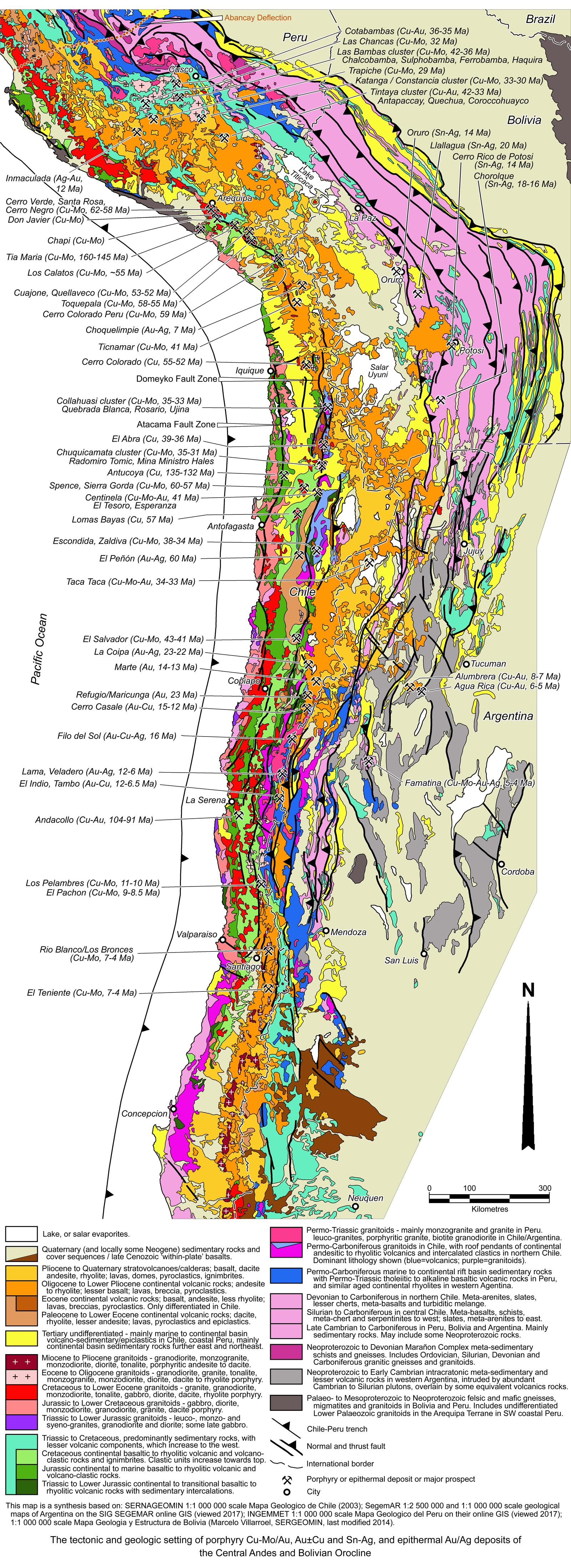 Click here to expand image
Tectonics and Geology
Within the broad framework summarised above, the geologic and tectonic history of the central Andes may be summarised as follows:
• Sunsás orogenesis - Ramos (2010) and other authors present evidence that as part of the amalgamation of the Rodinia supercontinent between 1200 and 1000 Ma, the eastern North American side of Laurentia collided with the Amazon Craton in what is now South America. The resultant orogenesis is reflected in the Sunsás Belt on the southwestern Palaeoproterozoic age margin of the Amazonian craton in Paraguay, Bolivia, southeastern Peru (largely under cover) and western Brazil. A pre-collision suite of ~1200 Ma passive margin quartzitic and conglomeratic units had been developed along this margin. In the Sunsás belt, these where intruded by 1105±21 Ma tonalite (U-Pb zircon; Matos in Teixeira et al., 2010), metamorphosed to a 1014±6 Ma orthogneiss (U-Pb zircon; Isla-Moreno, 2009) and cut by 1092 to 1047 Ma plutons (Vargas-Mattos et al, 2009), all of which were deformed and subjected to low- to medium-grade metamorphism. This orogen is a temporal equivalent to the North American Grenville and Australian Fraser-Musgrave events. Ramos (2008) argues that within the Bolivian Orocline in the northern extremity of the Central Andes, Laurentia and Amazonia were separated by a sandwiched allochthonous (with respect to Amazonia) sliver of Proterozoic rocks, now represented by the Arequipa terrane in coastal southern Peru. This terrane, which extends from the Abancay Deflection to the Peru-Chile border, is characterised by juvenile magmatism and metamorphism between 1.9 and 1.8 Ga, rejuvenated at ~1.0 Ga during a regional high-grade metamorphic event (Ramos, 2008). According to Ramos (2008;2010) the Arequipa terrane was accreted directy onto the Amazon craton, now partially concealed by deformed Palaeozoic cover. Docking is estimated to have occurred at ~1.05 Ga (Loewy et al, 2004).
Immediatley to the south and SE of the Arequipa terrane, the contiguous Antofalla terrane, sometimes interpreted to be a southern continuation of the Arequipa terrane (Ramos, 2008), is composed of two domains. The first occurs in southwestern Bolivia (from just south of Lake Titicaca) and in northern Chile, and is characterised by juvenile magmatism at 1.5 to 1.4 Ga and metamorphism at 1.2 to 1.0 Ga. It also includes amphibolites and gneisses with ages of 1745±27 Ma, 1877±130 Ma (U-Pb of zircons; Wörner et al, 2000), and 1866±2 Ma (Loewy et al, 2004), as well as orthogneisses dated at 507±48 Ma (U-Pb of zircons; Basei et al, 1996). The contiguous southern domain in northern Chile, extending obliquely into western Argentina to almost as far south as Tucuman, includes 0.7 to 0.6 Ga juvenile rocks. At the end of the Sunsás orogenesis, the Antofalla terrane appears to have been attached on its eastern margin to the Pampia terrane, which separates it from the Palaeoarchaean to Palaeoproterozoic Rio de la Plato craton further to the east. According to Ramos (2010), the 1500 x 250 km Pampia terrane was accreted to both the Rio de la Plato and Amazon cratons to the east and north respectively, during the Sunsás orogenesis, and extends southwards on the western margin of the Rio de la Plata craton. The Pampia terrane basement, almost completely masked by late Neoproterozoic to Palaeozoic rocks, is composed of gneisses and schists. It may be concluded that the Antofalla terrane was accreted to the Arequipa terrane from the south at the same time that the Pampia terrane/Rio de la Plata craton collided with the Amazon craton.
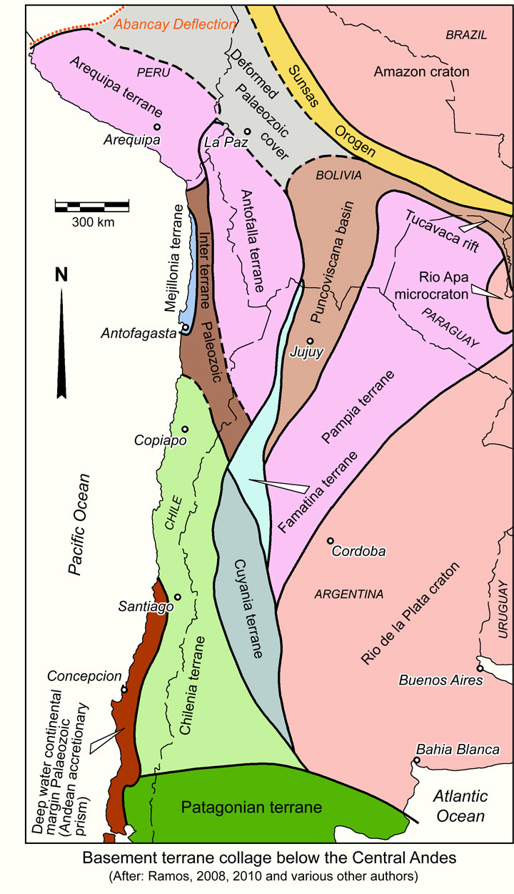
• The Pampean Tectonic Cycle from the Mid Neoproterozoic to Early Cambrian, incorporates the mid to late Neoproterozoic break-up of Rodinia during, and represents a predominantly extensional regime, commencing with the development of a broad shallow basin filled with intracratonic platformal clastic sedimentary rocks. The Rodinia break-up continued with the opening of the intervening Iapetus ocean in the mid-Neoproterozoic (Dalziel, 1997), with some Laurentian terranes remaining attached to South America/Gondwana, while others were rifted away with Laurentia. Some others that were detached during the breakup, were returned and amalgamated to Gondwana in the Early Cambrian to Middle Ordovician as part of the Terra Australis Orogen (Ramos, 2010; Cawood, 2005). According to Ramos (2008) there is no evidence of the Arequipa terrane having been detached from the Amazon craton.
During the late Neoproterozoic to Early Cambrian, extension within the remaining South American continent resulted in the development of the Puncoviscana basin in western Argentina between the Antofalla and Pampia terranes. According to Ramos (2008; 2010), from ~850 to 600 Ma, the rift opened along the north-south suture between the two terranes in a scissor-like fashion, with a pivot in the north to form a southward opening gulf. This pivot was at a triple juction with the smaller Tucavaca rift branching to the east to ESE, separating the Pampia(-Rio Apa) terranes and Amazon craton, and the unrifted suture joining the Arequipa terrane and the Amazon craton trending to the NW. With time, the Puncoviscana rift became a spreading centre, with the formation of oceanic tholeiitic rocks in the axis of the basin (Ramos, 2008). The main rift was filled with the Puncoviscana Formation, a sequence which is several thousand metres thick, composed of Late Neoproterozoic (Ediacaran) to Early Cambrian siliciclastic flysch-like turbidites, pelagic clays and minor shallow-water limestones, with locally thick lenses of conglomerate at the base. The main Puncoviscana Formation covers an ~800 x 150 km north-south belt that extends from south of Tucuman to the Bolivian border in the north. These sequences had an west to WNW pattern of sediment transport (Jerek, 1990), interpreted to have been supplied by highlands uplifted by the collision of the Pampia terrane and Rio de la Plata craton to the east. This sequence filled the main rift basin, but also spread across the entire Pampia terrane over a width prior to closure of up to 1000 km, extending east to the margin of the Rio de la Plata craton. Only minor Mesproterozoic basement is exposed in the Western Sierras Pampeanas (Baldo et al., 2005), where it is overprinted by Ordovician metamorphism. Limited alkaline rhyolitic to dacitic lava flows, sills and dykes in the lower part of the section show 'oceanic island' to 'within-plate' signature (Coira et al., 1990), while rift-related alkaline to transitional alkaline to MORB-like basalts appear higher in the section (Omarini et al., 1999). By 540 Ma, basin inversion and possibly subduction of the oceanic crust rift floor in the west had closed the basin and re-amalgamated the Antofall terrane onto the Pampia terrane (Ramos, 2008). The whole succession was tightly folded and metamorphosed prior to the emplacement of voluminous 560 to 520 Ma calc-alkaline post-orogenic granitoid batholiths (Toselli et al., 1992; Ramos, 2008). There is a continuous variation, generally from north to south and west to east, ranging from unmetamorphosed turbiditic rocks, through weakly foliated pelites, to schists with well-developed pressure solution cleavage, and finally to compositionally-banded schists and gneisses (Piñín-Llamas and Simpson, 2006). In the north, low-grade metapelites and metaturbidites dominate, grading to schists and gneisses toward the Rio de la Plata craton margin, with restricted alkaline lava, sills and dykes and 536 to 520 Ma peraluminous and calc-alkaline granites. To the south, near Cordoba in Argentina, medium to high grade Puncoviscana Formation equivalents comprise banded schists and gneisses, with 540 to 530 Ma calc-alkaline granitoids of an immature magmatic arc, and 520 Ma migmatites and anatectic S-type granites (Rapela et al., 2007). The Puncoviscana Formation and the granitoids are cut by a regional unconformity, overlain by Cambrian and Ordovician sedimentary rocks, dominantly orthoquartzites. Ophiolitic remnants, dated at ~625 Ma (Escayola et al., 2005; Sm-Nd) have been encountered along the margin with the Rio de la Plata craton, ascribed to closure of a back-arc basin (Escayola et al., 1996). The Puncoviscana Formation and equivalents are progressively concealed by Palaeozoic sedimentary cover to the north and NW (Ramos, 2008), but are exposed to deeper crustal levels revealing the high grade metamorphic rocks in the south, as described above, due to uplift produced by Miocene to Recent flat-slab subduction (Rapela et al., 2007).
To the west, in the western Puna of Argentina, Antofalla terrane rocks were subjected to high grade, LP-HT metamorphism dated at 500 to 525 Ma, taken to represent Pampean Cycle activity (Becchio et al., 1999, Lucassen et al., 2000).
• The Terra Australis Orogen developed along the Pacific/Iapetas margin of Gondwana, and was the end result of the Pampean Cycle rift break-up of Rodinia. It extended over a continuous pre-dispersal length of ~18 000 km and up to 1600 km width, from eastern Australia and New Zealand, along the periphery of Antarctica, and the entire western fringe of what is now the South American plate. Despite a long history of plate convergence, reorganisation and terrane accretion, the Pacific ocean has never subsequently closed. The Terra Australia Orogen has been both a passive and active margin at different times and localities since the Lower Palaeozoic (Cawood, 2005). Activity within this orogen included the following cycles.
• The Famatinian Tectonic Cycle - The inversion at the end of the Pampean Tectonic Cycle heralded the onset of a period of contraction, amalgamation and orogenesis, from Late Cambrian to Mid Devonian, and included the development of a number of significant magmatic arcs of lower to middle Palaeozoic age, as part of the Terra Australis Orogen. During this period of renewed plate convergence, subduction of the newly formed Iapetus oceanic plate below the South American margin of Gondwana was fully active by 485 to 465 Ma (Pankhurst et al., 1998; Cawood, 2005; Chew et al., 2007). This convergence included the progressive approach, collision and accretion of a group of exotic terranes of Laurentian and/or Gondwanan affinities that had followed Laurentia during the Rodinia break-up (e.g., Ramos et al., 1986; Astini et al., 1995).
To the north, in the Arequipa terrane in southern Peru, orogenesis is marked by the an Ordovician magmatic arc, where significant metamorphism (Loewy et al., 2004) was followed by the intrusion of massive granodiorites at 473 Ma into Palaeo- to Mesoproterozoic age basement (Loewy et al., 2003, 2004; Chew et al., 2008), This terrane was not detached from the Amazonian craton during the Pampean or Famatinian cycles, although a back-arc basin was developed along the old Mesoproterozoic suture between the two blocks (Sempere, 1995; Díaz-Martínez et al., 2000). This same suture zone remained a focus of weakness influencing emplacement of Late Palaeozoic and Oligocene-Early Miocene intrusions during extensional regimes, as well as controlling crustal delamination during the late Cenozoic (Jiménez and López-Velásquez, 2008; Beck and Zandt, 2002).
Famatinian magmatism has also been recorded along the 'exposed' western half of the Antofalla terrane, where granitoids cutting metamorphic basement have geochemical and isotopic characteristics typical of a magmatic arc, and yield U-Pb zircon ages of 473±3 and 472±2 Ma (Loewy et al., 2004). These rocks are foliated and a K-Ar age of 444±14 Ma may indicate the age of the metamorphic event (Pacci et al., 1981).
The Famatina terrane (or Eastern Sierras Pampeanas) takes the place of the Antofalla terrane in defining the western margin of the Pampia terrane immediately to the south of the latter. It has been interpreted as a piece of attenuated crust that was accreted to the continental margin in Ordovician times as part of the Terra Australis accretionary orogen (Quenardelle and Ramos, 1999; Astini and Dávila, 2004; Cawood, 2005). Rapela et al. (2010), have established the Mesoproterozoic age of the Famatina basement and the striking isotopic differences with the allochthonous Cuyania terrane that was subsequently accreted immediately to its west (see below). The Famatinian magmatic belt that extends from the Antofalla into the Famatina terrane, consists of widespread 500 to 463 Ma magmatic rocks, latest Cambrian to mid-Ordovician sedimentary rocks with distinctive Middle Ordovician epiclastic, volcaniclastic, volcanogenic and volcanic rocks in the Famatina terrane, and low- to high-grade metamorphic rocks (Pankhurst et al., 2000; Astini, 2003; Dahlquist et al., 2005). The boundaries of the Famatina terrane are predominantly defined by shear zones (Ramos, 2008).
The Cuyania terrane (also known as the Argentine Precordillera) is an allochthonous composite terrane with 'Grenville' aged basement rocks that have been interpreted to constitute the southern extension of the Appalachian system in Laurentia (Thomas and Astini, 1996). The basement of this terrane is composed by juvenile intraoceanic arc rocks (Kay et al., 1996; Vujovich and Kay, 1998), with a U-Pb in zircon age that varies from 1.2 to 1.0 Ga in different sectors of the terrane (McDonough et al., 1993; Kay et al., 1996; Casquet et al., 2001; Sato et al., 2004; Vujovich et al., 2004). A carbonate platform sequence was developed on the shallowly submerged Cuyania microcontinent (Ramos, 2004). Following collision, marked by an ophiolitic suture zone, subduction stepped back and continued below the Cuyania terrane until at least the Mid- to Late-Devonian, when the exotic Chilenia terrane collided with the amalgamated Cuyania-Pampean cratonic block over the same interval of the continental margin. The Cuyania terrane is interpreted to have been accreted to Gondwana during the late Middle Ordovician (Llanvirn), with eastward directed subduction of the intervening oceanic crust during its approach giving rise to the Famatinian magmatic arc (Astini et al., 1995). Following collision, the carbonate sequence was unconformably covered by extensive black shales. Silurian and Devonian siliciclastic sequences and the absence of volcanic or pyroclastic arc-derived rocks over the Cuyania-Famatina terranes indicate west-dipping subduction below the Chilenia terrane as it approached.
The Chilenia terrane also has Laurentian affinities, and occupies much of the area to the west of the Cuyania, Famatina and Antofalla terranes to the current Pacific coast. It is separated from the Cuyania terrane by an ophiolitic suture and is poorly exposed along the main axis of the Andean Cordillera. As it approached the continental margin during the Silurian and Devonian, a forebulge was established over the Cuyania terrane, developing an erosional unconformity. High grade metamorphic rocks are exposed west of the ophiolitic suture, and from their isotopic compositions, are interpreted to have been derived from the uplifted Cuyania terrane. They are interpreted to represent a metamorphosed accretionary wedge that resulted in a HP collisional Complex (Massonne and Calderón, 2008; Ramos, 2010). Final accretion of Chilenia during the Early Devonian (Charrier, et al, 2007) generated a regional angular unconformity between the lower and upper Palaeozoic. The Chilenia terrane is largely masked by post-Terra Australis orogenic rocks and is only preserved in erosional windows and roof pendants to Andean batholiths (Ramos et al., 1986). Chilenia terrane basement schist and gneiss have yielded ages as old as 1000 Ma (Ramos and Basei, 1997). Cover sequences and other younger rocks include Silurian carbonates and late Palaeozoic to Mesozoic Gondwanide granitoids.
The Mejillonia terrane, a further sliver of Laurentia, largely masked by younger rocks, but outcropping sporadically along the coast from Antofagasta to Iquique, is interpreted to have been accreted to the immediate west of the Antofalla Massif between 500 and 439 Ma, as indicated by subduction-obduction of ophiolites, and thrusting and folding of sedimentary rocks.
The Back-arc Basin to Intra-continental Trough - While this arc activity and episodes of collision were taking place along the Gondwana margin of South America, a considerable thickness of Ordovician to Lower Carboniferous sedimentary rocks were being deposited over a width of >500 km in Bolivia, Peru and Argentina. This sequence totalled more than 12 km in thickness and included Ordovician shale, phyllite, siltstone and sandstone-quartzite; Silurian diamictite and shale, a thick shale unit and overlying alternations of shale and sandstone. The overlying Devonian sequence included a similar cycle of a thick sandstone package, overlain by a shale unit and then an alternating suite of sandstone and shale, followed by Carboniferous sandstone, shale and limestone. This sequence is reconstructed from an imbricated package separated by a series of major detachments (McQuarrie, 2002; after Roeder and Chamberlain, 1995; Sempere, 1995; Dunn et al., 1995; González et al., 1996; Lamb and Hoke, 1997).
• The Gondwana Tectonic Cycle commenced in the Late Devonian and continued to the earliest Permian, and comprises rocks that are considerably more abundantly exposed than those belonging to the previously described cycles. At the close of the Famatinian Cycle, subduction had retreated to near the current coastline, the subducting plate dipping east below the now amalgamated Arequipa, Antofalla, Mejillonia and Chilenia terranes, accompanied by the development of a growing accretionary prism. Charrier et al., 2007 have divided the Upper Palaeozoic rocks in the central Andes into three stages:
i). Mid to Late Devonian to Early Carboniferous - which largely comprises a western, essentially turbiditic marine series, and an
eastern platformal marine series. The western turbiditic sequences essentially consist of thick, intensively and repeatedly folded successions of monotonous, medium to coarse grained turbidites, but also include strongly folded siltstone intervals, limestone and chert intercalations, and some metabasic rocks. The eastern platformal sequences are exposed in northern Chile along the Cordillera de Domeyko and the Principal Cordillera, and further south along the Chile-Argentina border and over the Precordillera. It comprises up to 5000 m of sandstones, siltstones, mudstones and conglomerates that have been deposited as a number of transgressive to regressive marine successions, interpreted to have been deposited on a north trending stable and shallow westward deepening marine platform (Bahlburg and Breitkreuz 1991, 1993; Breitkreuz 1986; Niemeyer et al., 1997). There is little evidence of any volcanic activity within these sedimentary sequences, other than rare pyroclastic intercalations and volcanic quartz crystals that most likely were derived from the Ordovician magmatic arc to the east in Argentina (Charrier et al., 2007).
The base of the Gondwana sequence is separated from the Famatinian succession by a well developed unconformity in the high Andes. However, further west, towards the coast, this unconformity has not been detected and was probably never developed, with the succession continuing un-interrupted from the Lower to Mid Palaeozoic in a marine domain in which an accretionary prism was later the developed. As a consequence, these rocks have not been differentiated from the Lower to Middle Palaeozoic sequences in the accompanying image above.
Many of these rocks were metamorphosed to greenschist to amphibolite facies, producing polyphase deformed quartz-mica and amphibole schists, marbles and some chert (Miller 1970, 1973; Maas and Roeschmann 1971; Reutter 1974; Godoy 1976; Thiele and Hervé 1984; Ribba et al., 1988; Irwin et al., 1988; García 1991; Rivano and Sepúlveda 1991; Rebolledo and Charrier 1994; Bahlburg and Hervé 1997). In the coastal zones of metamorphism, protoliths of the quartz-mica schists are greywackes and arkoses, whilst that of the amphibole schists have the composition of oceanic basalts (Irwin et al., 1988; García 1991; Rebolledo and Charrier 1994). The metamorphic age of these complexes in the high Andes include 335±20 and 304±40 Ma (Rb/Sr; Ribba et al., 1988), whilst those on the coast vary from 311±89 Ma (K-Ar; Irwin et al., 1988; García 1991) and 359±36 Ma (Rebolledo and Charrier 1994). To the south of Valparaiso, the metamorphic complex exposures are flanked to the east by the Late Carboniferous to Permian Coastal Batholith, and comprise two paired metamorphic belts, namely:
a). the eastern series predominantly composed of polyphase deformed metaturbidites and lenses of calcsilicate rocks, probably deposited in a fore-arc basin, exhibiting eastward increasing metamorphism towards the Coastal Batholith, with relatively low P/T ratios, locally reaching the amphibolite-granulite facies (Gana and Hervé 1983; Hervé et al., 1984). Metamorphism is dated at 368±42 Ma (Rb/Sr-whole rock of sillimanite zone) and 347±32 Ma (staurolite-andalusite zone further from the batholith); and
b). the western series, composed of polyphase deformed and metamorphosed sandstones, pelites, metacherts, metabasic rocks with sporadic pillow structures, and serpentinites (Godoy 1970; Aguirre et al., 1972; Hervé 1974, 1988; Gana and Hervé 1983; Duhart et al., 2001). These rocks were metamorphosed under high P/T, westward increasing ratios and include assemblages locally containing crossite, glaucophane, zussmanite and lawsonite (Saliot 1968; Herv&reacute; et al., 1984; Duhart et al., 2001). This series has been interpreted to interpret an east to west transition from deformed forearc basin to an accretionary complex (Kato 1985; Hervé 1988; Martin et al., 1999b; Willner et al., 2000) with metamorphism dated at 311±10 Ma (Rb/Sr on whole rock on glaucophane schists; Herv&reacute; et al., 1984).
ii). Late Carboniferous to earliest Permian - which is characterised by magmatic arc activity associated with a period of rapid continental drift and high convergence rate along the western margin of Gondwana. This high convergence and concomitant rapid uplift rate, close to the South Pole (as indicated by palaeomagnetic observations) also resulted in alpine-type glaciation along the mountain range and deposition of glacial deposits on either side of the range (Charrier, 1986). A thick, mainly silicic volcanic succession formed during this period in the Cordillera de Domeyko and the High Andes in Chile, unconformably covering the Mid to Late Devonian to Early Carboniferous eastern platformal succession. This volcanic sequence, which includes the widespread Collahuasi and La Tabla formations in northern Chile, comprises thick (1000 to 3000 m) dacitic, rhyolitic and subordinately andesitic volcanic successions
alternating with thick, generally coarse, fluvial and locally lacustrine intercalations, as well as subvolcanic intrusive bodies in the Precordillera and the High Andes of northern Chile. In some regions this volcanism was apparently continuous until, at least, Late Permian times. Large relict calderas (e.g., Mariposas, Imilac and Guanaqueros) and hydrothermal alteration in northern Chile have been attributed to this volcanic activity (Davidson et al., 1985). Dating of the La Tabla formation returned ages of 291±9, 268±11, 239±9 and 265±10 Ma (K-Ar; Marinovic et al., 1995).
Late Carboniferous to Early Permian intrusions and batholiths are distributed along the entire length of the Central Andes, gradually converging with the coast to the south, where, from just south of Santiago, they form the Coastal Batholith in the Coastal Cordillera forming a continuous swath of outcrops. North of 25°S these intrusions are accompanied by coeval volcanic rocks, but further south only the intrusives remain. Two main generations of granitoids are recognised, earlier foliated granitoids that are calcalkaline, I-type plutons which can be associated with subduction, and unfoliated granitoids that have geochemical signatures indicating a crustal origin (Charrier et al., 2007).
iii). Early to Middle and Late Permian - which occurs as a relatively uniform marine sequence distributed over a length of ~1200 km, and is generally composed of conglomerates and sandstones with shale intercalations and vary from 100 to >400 m in thickness. The sandstones are often calcareous, and locally contain some limestones, and in places the limestone may dominate (Charrier et al., 2007).
Each of the three Gondwana suites are separated by an unconformity, suggesting two main deformation events within the Gondwanan Tectonic Cycle. The first is of Mid Carboniferous age, while the second may be correlated with the late Early Permian San Rafael tectonic phase described in western Argentina (Charrier et al., 2007). However, the unconformity separating the first from the second stages of the Gondwanan Tectonic Cycle, similar to that at the base of the Gondwanan is not exposed in the west, because the Late Carboniferous to earliest Permian magmatic arc was located far to the east in the current high Andes of eastern Chile and adjacent Argentina, and the forearc basin formed a barrier to the volcanic deposition (Charrier et al., 2007).
Back-arc basin - Whilst there is a well defined subduction related compressional regime magmatic arc reflected by the volcanic terranes in the northern high Andes (Western Cordillera) of Chile north of 25°S, and a chain of batholiths extending to the SSW, in contrast, to the NE and east in Peru and western Argentina respectively, there is an up to 350 km wide extensional back-arc basin containing a sequence that spans the interval from Carboniferous to lower Triassic.
In Peru, this succession laps onto the Amazonian craton to the east, and unconformably overlies Lower to Mid Palaeozoic basement in the east. It commenced with a Carboniferous sequence, largely composed of sandstones, mudstones and limestones, deposited in a mosaic of intense intracontinental rift basins and horsts controlled and linked by strike-slip fault zones that have 'Andean trends' (Rosas et al., 2007). Permo-Carboniferous fault-controlled subsidence diminished and ceased by the Late Permian, followed by widespread regional subsidence and a broad epeiric sea into which argillaceous, organic-rich sediments were deposited as a regional blanket (Rosas et al., 2007). The latter reflected a tectonic hiatus related to the late Permian to early Triassic Juruá event (the Pre-Andean Tectonic Cycle described below), which was accompanied by synkinematic calc-alkaline granodiorites and granites, and alkaline to peralkaline comendites, basalts and syenites in the Cordillera Oriental, with an age range of 255 to 236 Ma (Rb/Sr, K/Ar; Lancelot et al., 1978; Dalmayrac et al., 1980; Gunnesch et al., 1990; Soler, 1991).
These rocks are discordantly overlain by the Permo-Triassic Mitu Group, also deposited in a complex of rift basins, the most significant of which was the extensive Mitu graben. It comprises as much as 3000 m of continental clastic molassic sediments/red beds, volcaniclastic rocks and alkaline volcanic rocks. Master faults along both the basin axis and margins, were the pathways for mantle-derived continental Mitu volcanism, mainly tholeiitic or alkaline basalts accounting for up to 20% of the sequence, that were accompanied and followed by the intrusion of a voluminous belt of crustally derived Permo-Triassic granodioritic to monzogranitic plutons, largely along the present Eastern Cordillera (Rosas et al., 2007; Panca, 2009).
In western Argentina, the back-arc extensional basin contains significant sequences of rift-deposited Permo-Carboniferous marine to continental sedimentary and epiclastic rocks and a thick succession of Permo-Triassic silicic volcanics, the Choiyoi Group (Rolleri and Criado Roqué 1968) or Choiyoi Magmatic Province (Kay et al., 1989). This group has been correlated with the Mitu Group in Peru, and can be divided into two volcanic suites with minor sedimentary intercalations (Llambías 1999). The older consists of Permian volcanic rocks of intermediate composition and calc-alkaline signature, most likely related to the subduction complex arc to the west. Where these occur in the Frontal Cordillera, on the eastern side of the Andean range, they formed between 272 and 260 Ma (Early Permian), following the San Rafael tectonic phase and has been assigned to the third stage of the Gondwana Tectonic Cycle. The younger suite has been dated between 259 and 247 Ma (latest Permian to Early Triassic; Llambías 1999) and 240±15 Ma and 238±10 Ma (Caminos 1970), and are included in the Pre-Andean Tectonic Cycle (see below). They comprise silicic, mainly rhyolitic, volcanic rocks, frequently ignimbritic, that are associated with subvolcanic intrusives. These rocks are associated with major 'A' and 'S'-type intrusions interpreted to have developed by intense crustal melting in an extensional regime, and as such are considered to be largely intraplate-type magmatism (Llambías and Sato, 1995).
In eastern Chile, across the border from the Choiyoi Group exposures, the similar rocks of the Pastos Blancos Group (Thiele 1964; Martin et al., 1999) consist of at least two units, one with rhyolitic and dacitic rocks (K-Ar 280 to 260 Ma; U-Pb zircon 265.8±5.6 Ma) and the other with bimodal basaltic to rhyolitic compositions (K-Ar 235±5 Ma; U-Pb zircon scattered from 225 to 210 Ma; Charrier et al., 2007).
• The Pre-Andean Tectonic Cycle, from the latest Permian to the earliest Jurassic, an interval of ~55 m.y., from ~240 to 194.5 Ma, following the final assembly of Gondwana and the Pangea super-continent, but preceded development of the Early Jurassic magmatic arc. During this period, subduction along the continental margin was interrupted, or at least considerably diminished, with polar migration curves for South America and Africa (Vilas and Valencio 1978) showing that, after a period of rapid continental drift during the Late Palaeozoic, a complete or almost complete pause in Gondwanan continental drift occurred in Late Permian to earliest Jurassic times. The cessation of subduction and mid-ocean ridge crustal accretion led to a reduction in interior heat loss to the surface and concomitant heat accumulation in the upper mantle, plume generation and melting of the lower crust, to produce large volumes of magmas along the northern Chilean coast (Berg and Breitkreutz 1983; Berg et al., 1983), in the high Chilean Andes (Kay et al., 1989; Mpodozis and Kay 1990) and on the Argentinian side of the Andes (Llambías and Sato 1990; Llambías et al., 1993; Llambías 1999, 2001). Consequent crustal up-warping and extension of the brittle upper crust resulted in the development of extensional basins, the NNW-SSE oriented geometry of which was influenced by existing Andean structures (Charrier et al., 2007 and sources quoted therein). The resulting pattern of grabens or semi-grabens and horsts were apparently oblique to the continental margin of Gondwana, producing an uneven coastline with embayments and peninsulas. Those grabens that intersected the coast contained marine sequences, while the rest were filled with continental successions.
Bi-modal Permian to Triassic volcanism is widespread, as described in more detail above in the 'back-arc basin' segment of the Gondwana Tectonic Cycle section, particularly the Mitu and Choiyoi groups characterised by mafic and felsic volcanism respectively and the Pastos Blancos Group. These volcanic episodes are described previously because of the overlap of extension spanning both the late Gondwana and Pre-Andean cycles. In addition to these volcanic sequences, others are found further to the west in Chile and into the coastal belt, where basaltic and andesitic volcanism is also evident. With respect to the sedimentary fill of the series of NNW-ESE trending faulted basins caused by this extensional event, two rift stages have been identified:
a). Late Permian, containing successions that may be 2000 to >4000 m thick, now in the Coastal and Principal Cordillera, containing siliceous lavas and pyroclastic deposits (similar in age to the younger Choiyoi Group in the high Andes as described above), subordinate mafic lavas, and red clastic units containing conglomerates, sandstones and shales with crinoidal limestone intercalations and turbidites; and
b). late Triassic to early Jurassic deposits which are found widely from the Coastal Cordillera to the Cordillera de Domeyko (Chong 1977; Chong and von Hillebrandt 1985; von Hillebrandt et al., 1986; Suárez and Bell 1992), transgressively overlying Permo-Carboniferous units such as the La Tabla Formation (von Hillebrandt et al., 1986). This younger rift stage included coarse-grained, poorly sorted fluviatile successions, with intercalations of volcaniclastic alluvial fans, small lakes and sabkha deposits, progressing to shallow marine succession of conglomerates and sandstones with thin fossiliferous intercalations followed by turbiditic intervals, siltstones, limestones, and some conglomeratic intercalations in the the earliest Jurassic.
Both of these stages contains cycles of transgression and regression with continental and marine facies and pulses of volcanism. In addition to the volcanic and sedimentary rocks described above, extensive coeval plutonic activity is evident during the Late Permian to Early Jurassic. These include plutons exposed in both the high Andes and along the Pacific Coast. The former comprise a continuous plutonic belt that corresponds to a post-collisional, epizonal association including granitoids derived from deep, garnet-bearing levels in a thickened crust, and hypersilicic, calc-alkaline to transitional 'A'-type granites, indicating extensive crustal melting of a garnet-poor crust (Mpodozis and Kay 1990). These intrusions are coeval with the younger portion of the Choiyoi Group (Llambías, 1999).
Plutons exposed along the Pacific coast have yielded ages that cover the entire age range of the Pre-Andean Tectonic Cycle (Berg and Baumann 1985; Grocott et al., 1994; Godoy and Lara 1998). For example in the Chañaral-Caldera region, between Antofagasta and Copiapo, Late Permian intrusions are composed of syenogranitic and granitic rocks; Triassic intrusions are represented by the monzonite and syenogranite that are leucocratic 'S'-type granitoids; whilst Early Jurassic intrusions dated at between 202 Ma and 186 Ma have a calcalkaline character (Berg and Breitkreuz 1983;Breitkreuz 1986; Berg and Baumann 1985; Grocott et al., 1994; Dallmeyer et al., 1996), possibly indicating the recommencement of subduction.
According to Ramos (1994), the major faults controlling rifting during the Pre-Andean Tectonic Cycle coincide with zones of
weakness that, in turn, correspond to the suture zones of terranes accreted or re-accreted during the Famatinian and Pampean tectonic cycles.
• The Andean Tectonic Cycle, which spans the interval from the late Early Jurassic to the present and differs from the Gondwana Tectonic Cycle in that it lacks evidence of collision of major terranes. Following the Permo-Triassic to Early Jurassic period of plate tectonic quiescence, subduction was re-established in northern Chile and southern Peru during the Late Early Jurassic with a new magmatic arc developed in the current Coastal Cordillera, ~100 km west of the extinct late Palaeozoic arc front in what is now the high Andes. Since then, subduction has proceeded uninterrupted to the present with a series of pulses and changes in rate and sense of plate convergence, with a gradual eastward migration of the centre of arc development with time, and may be subdivided into the following intervals:
i). Late Early Jurassic to Late Early Cretaceous - The 40 to 50 m.y. of plate tectonic inactivity and probable detachment of the Palaeozoic slab during the Triassic, meant that the oceanic plate was old, cold and of higher relatively density, and hence subducted at a high angle to form a steep Mariana-style subduction zone and an extensional regime (Charrier et al., 2007). This resulted in magmatism on the western margin of Gondwana, and back-arc extension to the east. This period of activity is characterised by the development of an essentially north-south orientated magmatic arc along the present-day Coastal Cordillera and an extensional regime that permitted the formation of a series of interconnected back-arc basins to the east of the main arc, which were progressively filled with marine and continental sedimentary strata (Mpodozis and Ramos, 1989, 2008). Transpressional deformation along the arc axis created the intra-arc Atacama fault system in northern to central Chile (Scheuber and González, 1999).
In northern Chile, the lowermost units of what some authors call the La Negra volcanic arc, is the La Negra Formation, which overlies the Late Triassic Pre-Andean volcanic and sedimentary sequence without a discernable unconformity, and comprises ~80% of the present day Coastal Cordillera. Deposition commenced in the late Early Jurassic (late Sinemurian to early Pliensbachian) with peak magmatic activity between 159 and 137 Ma, and persisted until the Late Jurassic, to accumulate a thickness of from 7 to 10 km of volcanic rock (Boric et al., 1990; Buchelt and Tellez 1988; González and Niemeyer 2005). It is mostly composed of locally pillowed andesitic and basalt-andesitic lavas, with subordinate intercalations of continental and marine volcanoclastic and calcareous deposits. Locally (e.g. east of Antofagasta), the lowermost levels of the La Negra Formation contain silicic ignimbritic deposits (Muñoz et al., 1988; Muñoz 1989). Volcanism evolved with time from an initial stage of tholeiitic to a calcalkaline affinity in more evolved stages, and more alkaline signatures in its latest stages (Losert 1974; Palacios 1978, 1984; Rogers and Hawkesworth 1989; Pichowiak 1994). Low 87Sr/86Sr ratios are interpreted to indicate little crustal contamination, and the existence of an attenuated crust (Rogers and Hawkesworth 1989). Muñoz (1989) advanced evidence suggesting volcanic activity around a series of central vents, although on the basis of the geochemical signature, some authors (e.g., Scheuber et al., 1994), considered the La Negra Formation, to have, at least at an early stage, been the result of fissure volcanism. The extrusion of such volumes of volcanic rocks, essentially at sea level, with no significant positive relief meant it had to be accompanied by considerable crustal subsidence, most likely related to an extensional setting of the whole Jurassic magmatic belt (Scheuber et al., 1994; Dallmeyer et al., 1996). Structural evidence also suggests the La Negra volcanic succession underwent extension subsequent to deposition and prior to the emplacement of the next stage of volcanic activity (Scheuber et al., 1994). Locally this sequence is overlain by up to 1300 m of coarse Late Jurassic to Early Cretaceous conglomerates and sandstones with volcanic intercalations, or further thinner volcanic rocks or marine sedimentary rocks (Charrier et al., 2007).
From north of Copiapo, the La Negra Formation is overlain with a transitional boundary by the Late Jurassic to early Lower Cretaceous volcanic to volcaniclastic Punta del Cobre Formation, which comprises a lower, mainly volcanic member, and an upper, dominantly volcaniclastic member. It is predominantly composed of andesitic volcanic rocks, volcaniclastic breccias, conglomerates and tuffaceous rocks with lenses of massive andesitic volcanic rocks. Eastward the sequence passes into thinner volcanic aprons that interfinger with the back-arc sequence. Further south, near La Serena, the arc is represented by the Early to Middle Jurassic ~6400 m thick Agua Salada Complex composed of andesitic lavas and tuffs with limestone intercalations, mixed ignimbrites and andesitic lavas, with subvolcanic porphyritic andesitic and dioritic stocks, sills and dykes. Neither the base nor top of this unit is exposed. It is overlain by Lower Cretaceous andesites and subordinate rhyolitic lavas with marine calcareous intercalations, and by an up to 1900 m thick unit of coarse continental
and fine sedimentary and volcaniclastic rocks and lavas, with a marine calcareous and fossiliferous intercalations near to the base (Charrier et al., 2007).
These volcanic piles are intruded by a series of Early Jurassic to Early Cretaceous calc-alkaline plutons and dykes that range from gabbro-norites, gabbros and diorites, through quartz diorite, leucocratic tonalites, biotite and hornblende granodiorites, to biotite granodiorites, locally with phases as felsic as monzogranite. Abundant basaltic to andesitic dykes cut many of the plutons and their country rocks. These intrusions together constitute the coastal batholith. Individual plutonic complexes were emplaced over intervals of 3 to 14 m.y. (Dallmeyer et al., 1996). Particularly to the north and south of Copiapo, these intrusions were emplaced under transtensional tectonic conditions and contemporaneously with sinistral strike-slip movements along the Atacama Fault Zone. South of La Serena, Jurassic and Early Cretaceous plutonism appear to have been virtually continuous, forming a long, narrow belt of epizonal bodies along the Coastal Cordillera composed of monzogranites, syenogranites, diorites, monzodiorites, tonalites and granodiorites, mostly bounded by faults (Charrier et al., 2007 and sources quoted therein).
Back-arc deposition varies considerably, ranging from bituminous marine pelites to limestones, coarse red detrital deposits of conglomerates, sandstones and shales with anhydrite lenses and intercalated lavas and volcaniclastic rocks, reflecting cycles of transgression and regression, to develop sequences of up to 2000 m in thickness. Two major extensional episodes are evident coinciding with the beginning of each of the two sections of the arc as described above, in late Early Jurassic and in the Upper Jurassic Kimmeridgian. The Kimmeridgian extensional event resulted in the deposition of thick, mainly coarse continental and volcanic deposits, and was apparently more intense than the Early Jurassic extension, allowing the development of abundant volcanic activity in the backarc basin. While the arc remained close to sea level through most of the period, the back-arc was mostly well below sea level. The two episodes in the back-arc are separated from each other by an episode of abundant continental sedimentation and in some regions intense volcanic activity (Charrier et al., 2007). The back-arc sequences extend as far east as the Cordillera de Domeyko in the high Andes of northern Chile. South of La Serena, the late Jurassic to early Cretaceous section of the arc, a western fore-arc sequence and the the back-arc basin curve to the east to cross the main tectonic grain of the Andes and trend north-south to NNW-SSE, transgressing over the Lower to Mid Jurassic sections of the arc and back-arc basin. The equivalent upper back-arc basin flairs out to a width of up to 300 km eastward from the arc into Argentina where it becomes the Mendoza-Neuquén Basin. In this southern region, the fore-arc basin overlies the lower section of the arc and comprises as much as 7000 m of marine and continental Late Jurassic to early Cretaceous marine sandstones (including some turbidites), breccias, conglomerates and calcareous deposits in the lower portion, and alternating marine and continental sedimentary deposits with thick volcanic intercalations (Charrier et al., 2007 and sources quoted therein).
The Atacama Fault System, which is one of the major structural elements in the Chilean Andes, concentrated deformation in the Coastal Cordillera, and has been at least intermittently active since Early Jurassic times. It is a continent-scale, trench-parallel strike-slip fault that can be traced for >1000 km, extending from Iquique in the north, to south of La Serena. The main trace of this fault system has been subdivided into at least four major curved segments. It cuts through the plutonic rocks of the Jurassic and Early Cretaceous magmatic arc, suggesting a reduction of crustal strength caused by the high heat flow in the arc. Sinistral as well as dextral displacements have been recorded, suggesting contemporaneous oblique convergence, whilst vertical movements have also been reported for younger stages. Both ductile and brittle deformation is evident.
Following the first arc activity in the Early Jurassic (late Sinemurian), with the first appearance of lavas overlying Early Jurassic strata, the oldest structures exposed are middle to deep crustal mylonitic rocks and brittle faults formed in Middle to early Late Jurassic times, with a consistent sinistral sense of shearing. Abundant evidence indicates shearing on the Atacama fault and magmatic arc activity were simultaneous. An extensional stage followed in the Late Callovian (late Middle Jurassic), which permitted emplacement of late Jurassic plutons (160 to 150 Ma), that, in turn, were affected by ductile normal faults with cooling ages of 152±4 Ma. A switch from normal slip to sinistral transtension occurred at ~132 Ma (Scheuber and Gonzalez, 1999; Grocott and
Taylor, 2002), and younger stages were accompanied by an oblique tensional stress regime in the Early Cretaceous, mainly evident in brittle crust, reflected by parallel dykes, followed by a sinistral transpressive regime represented by steeply dipping brittle faults (Charrier et al., 2007 and sources quoted therein). Fission track ages suggest exhumation of deep-seated sheared arc units and possible uplift of the Coastal Cordillera occurred in this region in late Early Cretacous Aptian-Albian times (Maksaev 1990; Scheuber and Andriessen 1990).
This first Early Jurassic to Early Cretaceous stage of the Andean Tectonic Cycle was terminated by a pulse of Late Cretaceous compressive deformation that inverted the former backarc basin and created a major regional unconformity. Charrier et al. (2007) suggest the extensional tectonic regime that had persisted through the Jurassic is probably the result of the subduction boundary maintaining a tendency to retreat throughout the period, in part through slab steepening, but possibly also through continued thermal uplift of the asthenospheric wedge underneath the arc and back-arc domains.
Mineralisation - Rocks of this stage host the Middle Jurassic to Early Cretaceous Cu belt of the central Andes over a semicontinuous interval of 2300 km, from southern Peru to central Chile, distributed along the Coastal Cordillera immediately inland of the Pacific coast, and averages
~30 km in width. It contains a variety of Cu bearing deposits, including porphyry Cu, IOCG and related and manto Cu types and to the north, Cu-bearing VHMS deposits, including Cerro Lindo just to the NW of the margin of the belt in southern Peru largest in southern Peru. The largest Cu deposits include the Late Jurassic Tia Maria in southern Peru and the Mid to late Cretaceous porphyry deposits at Antucoya and Andacollo in northern and central Chile respectively), the IOCG Mantoverde,
Santo Domingo,
Candelaria - Punta del Cobre, and manto-type Cu at Michilla,
Mantos Blancos and El Soldado (after Sillitoe and Perelló, 2005). The porphyry
Cu deposits contain Mo but are relatively poor in Au, with the notable exception of Andacollo which has an associated epithermal overprint. According to Sillitoe and Perelló (2005), deposits of this age group produced ~10% of Andean copper at that time.
ii). Late Early Cretaceous to Early Eocene - During the Cretaceous, a major change in plate interaction took place along the continental margin of southern Peru, and north and central Chile. This has been interpreted to have been related to faster convergence rates instigated
by the global mid Cretaceous superplume event to the east and a late Early to Late Cretaceous phase of rapid oceanic crustal generation from reconfigured spreading centres in the primitive Pacific Ocean (Larson 1991). This, in turn, was probably linked to a consequent reduction of the subduction angle when the faster moving, hotter, and consequently more buoyant oceanic crust began to be subducted below South America, and an associated upsurge in volcanism along the Andean margin.
These modifications also led to the termination of deposition of the second regressive episode of the earlier back-arc basin, culminating in uplift and the emergence of the continental margin during an episode of intense contractional deformation in the early Late Cretaceous, accompanied by inversion and erosion of pre-existing units, particularly the earlier back-arc basin fill. They also led to the palaeogeographic reorganisation of the Central Andes, with the magmatic arc shifting considerably to the east, the formation of a continental foreland basin, instead of an extensional back-arc basin, and a wide fore-arc to the west. This early Late Cretaceous event is known as the Peruvian orogeny dividing the earlier dominantly Mariana style subduction and extension, from the Andean style subduction and largely continental magmatism that commenced in the Late Cretaceous.
Oblique subduction prevailed following this reorganisation, due to the new post 75 Ma ENE directed convergence of the Farallon oceanic plate towards the continent, producing dextral displacement along north-south orientated longitudinal faults and associated intra-arc extension and transtension (Scheuber et al., 1994; Reutter, 2001; Mpodozis and Cornejo, 2012). This new regime is characterised by extensional episodes along arc related structures, with associated intense magmatic activity, represented by major plutons and abundant volcanic deposits of andesitic and rhyolitic to dacitic rocks, frequently associated with the development of large calderas. The Late Cretaceous magmatism associated with this phase accumulated in a series of fault controlled extensional basins distributed along the magmatic arc. This new regime was modified by rifting which commenced with the Salta Rift in the Andean foreland of northwestern Argentina during the Early Cretaceous, and migrated westward to reach the western margin of the basin in northern Chile in the Late Cretaceous (Uliana and Biddle,1988; Salfity and Marquillas, 1994). This rift event has been attributed to a continental-scale extensional event linked to the opening of
the Atlantic Ocean.
Arc deposition and plutonic activity was apparently virtually continuous from the early Late Cretaceous to Early Eocene in northern and central Chile, although thick conglomeratic deposits suggest important tectonic activity, and breaks are reflected by two unconformities. The first of these is more local developed at the Early to Late Cretaceous boundary at ~90 to 80 Ma, and is interpreted to be the result of a local reactivation of the extensional conditions similar to those active in the previous Jurassic to Lower Cretaceous stage, while the second, which is more widespread, and close to the Cretaceous-Tertiary boundary, reflects the intense, short-lived compressional Incaic I event (Cornejo et al., 2003). This compressive event was followed by renewal of extension, although with less intensity than that of the late Early to Late Cretaceous. This Early Paleocene extension was associated with abundant volcanic and shallow plutonic activity and was followed by a new compressive deformation during the Eocene, the Incaic II event, that ended the Late Early Cretaceous to Mid Eocene stage of Andean evolution and resulted in the cessation of activity in the magmatic arc. This compressive pulse corresponded to an increase in the convergence rate of the Farallon Plate to a rate of >10 cm/year, between 49.5 and 42 Ma (Pilger 1994; Pardo-Casas and Molnar 1987). The precise timing of the overall event is uncertain, estimated at 38.5 Ma by Hammerschmidt et al. (1992), ~44 Ma according to Tomlinson and Blanco (1997) and 45 to 33 Ma (Mpodozis and Cornejo, 2012).
Arc deposition during the Late Cretaceous comprised essentially volcanic and volcaniclastic successions of variable thickness, and thick, mainly conglomeratic continental sedimentary accumulations. The volcanic sequences include andesitic and dacitic lavas, breccias, lahars and welded lapilli tuffs with subordinate ignimbrites, conglomerates and sandstones (e.g., the 69 and 65 Ma Cerro Empexa Formation), as well as thick acid volcanic sequences and complexes which include rhyolite and dacite domes and ignimbrites, associated with caldera collapse, as well as thick, mainly conglomeratic continental sedimentary accumulations. These units vary from a few hundred to a few thousand metres in thickness. Intrusions within the arc include pyroxene and biotite monzodiorite, granodiorite and hornblende and biotite granite plutons, and localised dacitic and rhyolitic porphyries.
The unconformably overlying Paleocene to Lower Eocene arc comprises continental volcanic sequences and complexes of dacitic and rhyolitic pyroclastic rocks and dykes associated with calderas, and intrusions of pyroxene monzodiorites, biotite granodiorites, hornblende monzogranites, biotite diorites and
gabbros, and localised dacitic and rhyolitic porphyries, variously dated at between 65 and 33 Ma.
The outcrop width of the preserved arc deposits of the two sequences (late Early to Late Cretaceous and early Palaeogene), in the central parts of the arc, from the Central Depression to the western Altiplano (Marinovic et al., 1995), indicates that the width of the volcanic arc was probably >100 km (Scheuber et al., 1994). The Late Cretaceous to Eocene intrusions are found in the Central Depression, along the Precordillera and western Altiplano, and the western flanks of the Sierra de Moreno and the Cordillera de Domeyko, although they constitute cover smaller outcrops areas than the older Mesozoic plutons of the Jurassic to early Late Cretaceous stage stage (Marinovic et al., 1995; García et al., 2004). They were emplaced in both older Mesozoic units and into the coeval magmatic arc rocks, and are geochemically similar in composition to the latter, being alkali-rich and subalkaline in character (Marinovic et al., 1995).
The foreland basin was filled with syntectonic alluvial and coarse fluvial deposit, which include Late Cretaceous to Eocene basal conglomeratic and coarse sandstone members, limestones, fine-grained sandstones and mudstones with frequent evaporitic intercalations as well as basaltic lavas and tuffs.
Mineralisation - Rocks of the Late Early Cretaceous to Early Eocene stage of the Andean Tectonic Cycle host the Paleocene to early Eocene belt of deposits, the third largest Cu concentration in the central Andes, which extends for ~1900 km, from Arequipa in southern Peru to Antofagasta in central Chile, averaging 30 to 50 km in width. It is predominantly defined by porphyry copper deposits, but also contains several related, but generally small tourmaline-bearing breccia pipes, mainly south of Copiapo, an enargite-bearing vein deposit at El Guanaco and an IOCG vein at Dulcinea.
The most significant porphyry Cu deposits are all Mo rich and include a cluster in southern Peru near the northern extremity of the belt, including Cuajone, Quellaveco, Toquepala and Cerro Verde. The Cerro Negro and Santa Rosa breccia deposits are found close to Cerro Verde. Other important deposits further south in northern Chile include Spence,
Sierra Gorda,
Cerro Colorado
and Lomas Bayas.
Deposits in this temporal group had accounted for more than half of Peru's production to 2005 (Sillitoe and Perelló, 2005).
The Domeyko Fault System and Bolivian Orocline - The Domeyko Fault System extends over a length of >1000 km, and is from 40 to 60 km wide, paralleling the Andean orogen in northern Chile. It fades into the core of the Bolivian Orocline, although a number of sporadic fault traces into southern Peru to Arequipa might suggest a possible extension to the NW. It comprises a complex segmented system of first, second and third order en echelon faults strike-slip, normal and reverse faults, accompanied by thin and thick skinned folds and thrusts, which follow the Cordillera de Domeyko in northern Chile from 20° to 27°S (Mpodozis and Cornejo, 2012). Evidence for both sinistral and dextral displacement, including reversal in the sense of shear, has been reported along different parts of the faulted domain (Reutter et al., 1996; Dilleset al., 1997; Tomlinson and Blanco 1997; Hoffman-Rothe et al., 2004; Niemeyer and Urrutia, 2009).
Some authors (e.g., Tomlinson et al., 2001; Mpodozis et al., 2005) suggested this fault system and related folds were initiated during the early Late Cretaceous inversion of the first stage Andean Cycle back-arc basins, reactivating normal faults inherited from the Mesozoic back-arc extension (Peruvian orogeny), to form a proto-Cordillera de Domeyko, whilst a second main tectonic pulse during the Incaic II event, produced its final uplift (Reutter et al., 1991, 1996; Scheuber and Reutter 1992; Tomlinson et al., 1993; Maksaev and Zentilli, 1999). During the Late Cretaceous, the Nazca plate began to move towards the South American plate and a gradual increase in the rate of convergence resulted in slab flattening (Skewes and Stern, 1995; James and Sacks, 1999). According to Pardo-Casas and Molnar (1987) the most rapid convergence (>15 cm/year) occurred between 50 and 42 Ma (Incaic I and II cycles) and since 26 Ma (Quechua cycle). Between these periods, the average rates were 5 to 5.5 ±3 cm/year. These periods of rapid convergence coincide with the culmination and development of the Domeyko Fault Zone (Camus, 2005). Parts of the Domeyko fault system were subsequently reactivated during the Oligocene and the Quaternary (Tomlinson and Blanco, 1997; Audin et al., 2003; Soto et al., 2005).
Mpodozis and Cornejo (2012) advance an argument that the principal phases of formation of the Domeyko Fault System was, as stated above, during the Incaic II event, and is essentially a consequence of the formation of the Bolivian Orocline. They detail the observations and conclusions they and previous authors they cite, have made as to the origin, timing and form of the Domeyko Fault System as follows. A detailed study of the distribution of palaeomagnetic declination vectors measured in the Central Andes shows that Mesozoic and Paleogene rocks, independent of their age, have been rotated by as much as 50°, with the sense of rotation being anticlockwise in coastal southern Peru, clockwise in northern Chile south of Antofagasta, and a negligible amount between. South of Antofagasta, the clockwise rotation progressively decreases and essentially disappears between Copiapo and La Serena. North of the Abancay Deflection in Peru, the magnitude of the anticlockwise rotation rapidly decreases. In comparison, rotation of Miocene and younger rocks (i.e., <18 to 11 Ma in northern Chile and <20 Ma in southern Peru) is very low. These observations are interpreted to imply that most of the rotation took place during a single Paleogene episode of deformation (Roperch et al., 2006, 2011; Arriagada et al., 2008, and references therein). These rotations are interpreted to have marked the development of the Bolivian Orocline (also known by some authors as the Arica Elbow). Structural studies (Lamb, 2001; Müller et al., 2002; Kley et al., 2005; McQuarrie, 2006) indicate that ~60% of the shortening within the core of the Bolivian Orocline occurred between 40 and 20 Ma. Mpodozis and Cornejo (2012) note that Incaic II shortening was concentrated as a series of imbricate thrusts that have deformed the >12 km thick, mechanically weak, Palaeozoic marine sequence within the Eastern Cordillera of Bolivia. The amount of horizontal shortening reaches a maximum near the axis of the orocline, where the Palaeozoic sedimentary sequence is thickest, and decreases symmetrically along-strike (Oncken et al., 2006; Gotberg et al., 2010, and references therein). Modelling to restore the Peru-Chile Trench to its 45 Ma position, prior to formation of the Bolivian Orocline (Arriagada et al., 2008), removing the combined accumulated horizontal shortening and block rotation, suggests a more linear, but still NE convex, but generally NW trend. This work also took into account the approach vector of the Farallon oceanic plate with an azimuth of ~30°, more closely orthogonal to the Peruvian coast to the north, but oblique to the Chilean coastline, potentially fostering margin parallel dextral shear/strike-slip faulting in northern Chile where the Domeyko fault system was formed. 'Bending' to form the orocline has been interpreted to have been accompanied wholesale NE-directed crustal flow on its southern limb, which is also required to explain the excess orogenic volume and crustal thickness below the Altiplano-Puna (e.g., Kley and Monaldi, 1998; Hindle et al., 2005) where thick Tertiary and Quaternary deposits have accumulated. This mass transfer is considered to have accompanied lower crustal flow towards the centre of the orocline (Hindle et al., 2005), accommodated by strike-slip faulting along the Domeyko fault system. Continued displacement was likely initially blocked near the orocline axis where deformation was dominated by margin-normal contraction.
Whilst the Domeyko Fault System was apparently initiated during the closing phases of the Late Early Cretaceous to Early Eocene stage of the Andean Tectonic Cycle, straddling the temporal boundary with the succeeding cycle, it seems to have little influence on mineralisation from the former cycle, which was emplaced prior to the formation of this structure, but had a profound influence on the localisation of younger post-Mid Eocene deposits.
iii). Mid Eocene to Recent - During this interval, the Central Andes were uplifted and developed their current configuration and morpho-structural forms. In addition, the magmatic arcs continued their eastward migration from their Early Jurassic to Early Cretaceous axis in the Coastal Cordillera to the present line of recent stratovolcanoes in the high Andes.
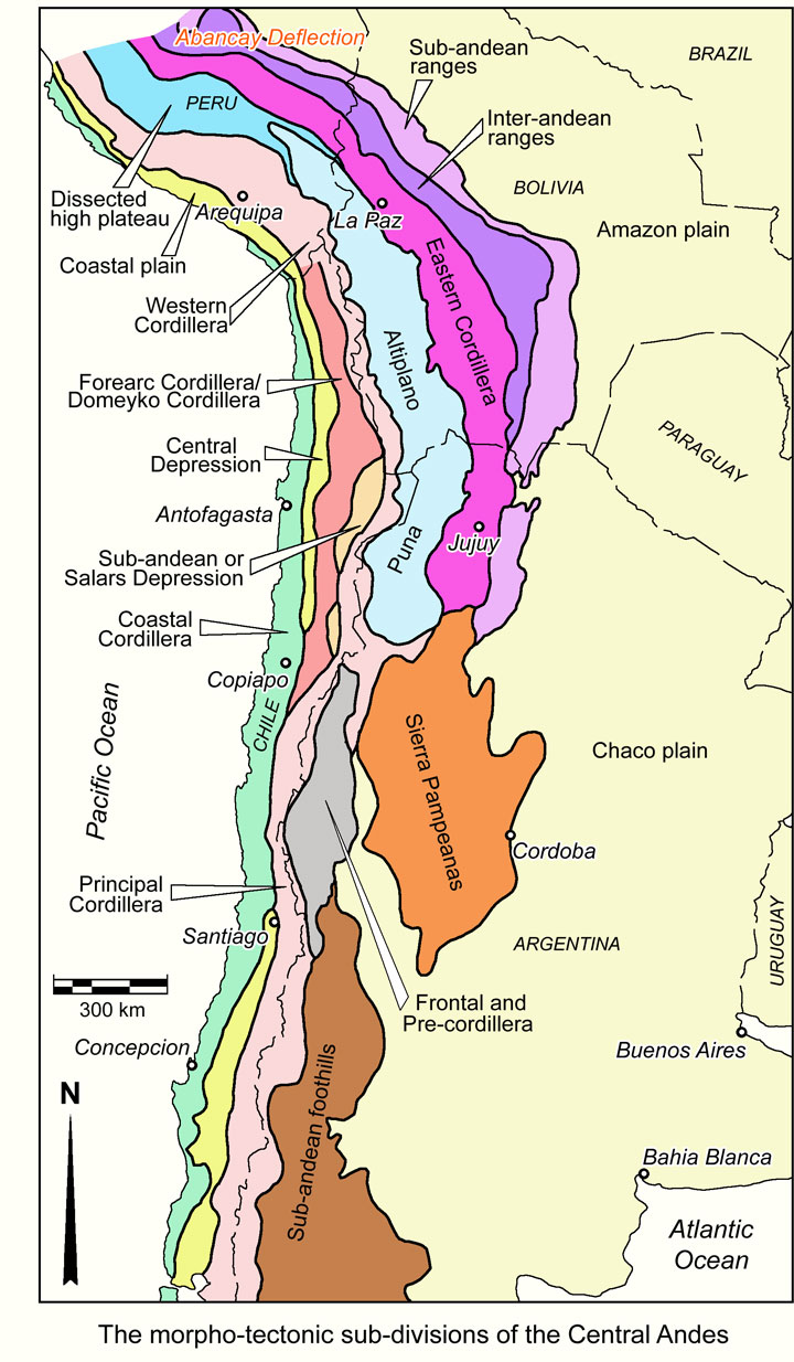
Morpho-structural units of the Central Andes - The principal of these may be summarised as follows after Charrier et al. (2007):
The Coastal Cordillera - a 1000 to 2000 m high range with a very steep coastal cliff, and a well preserved flat upper surface, largely occupied by Mesozoic arc rocks and associated intrusions of the Coastal Batholith. To the south of Valparaiso, late Palaeozoic sequences and batholiths dominate instead. The range extends along the Pacific coast from south of Valparaiso, continuously to the Abancay Deflection in Peru. In southern Peru, the Mesozoic arc rocks overlie exposed Proterozoic basement of the Arequipa terrane.
The Central Depression - which is developed almost continuously from north of the Abancay Deflection in southern Peru, to south of Concepción in southern-central Chile, and is only absent over the 'flat-slab' segment from just to the north of Santiago to a point between Copiapo and Antogafgasta, as a consequence of major uplift caused by the subduction of the Juan Fernández Ridge on the Nazca oceanic plate below the western margin of South America. It is is a longitudinal valley, that varies from almost 0 to >50 km in width, flanked by the Coastal Cordillera to the west and the next cordillera or range to the east, depending on its location along the Andes, and is generally filled by almost flat-lying, generally unconsolidated sedimentary and volcaniclastic continental succession, up to 1000 to 1500 m thick, of variable age from Oligocene to Holocene. In far southern Peru it is known as the Coastal plains where the Coastal Cordillera is only poorly developed, while to the north, just south of the Abancay Deflection, it is the Para-Andean Depression.
The Western Cordillera (or Cordillera Occidental) - This range varies considerably along the length of the Central Andes and has a range of names and subdivisions. In southern Peru, it is a broad range, up to 120 km wide and to >4000 m high, exposing the Coastal Batholith, Mesozoic rocks and Tertiary arc sequences and is the site of current arc activity. To the SE, where it passes into Chile, it is also the focus of current volcanic arc, represented by a series of stratovolcanoes and sheets of Miocene to Holocene basaltic to rhyolitic volcanic and volcano-clastic rocks. In Northern Chile, it is also the focus of a suite of structures on its eastern margin known as the East-Vergent Thrust System that have been active from the Miocene to present. In northern Chile, the western margin of the Western Cordillera is occupied by a string of almond-shaped depressions, collectively referred to as the Subandean or Salars Depression, which can be traced south to the latitude of Copiapo. The largest of these is the 120 x 60 to 90 km Salar de Atacama. These depressions, where present, separate the Western Cordillera from the Forearc Precordillera, which corresponds to the Cordillera de Domeyko that continues south through, and hosts, major porphyry copper deposits at Collahuasi, El Abra, Chuquicamata, Escondida and El Salvador. This range/cordillera was formed by uplift and displacement on what is known as the West-Vergent Thrust System, a series of reverse faults that uplift and thrust Palaeozoic and Mesozoic successions over poorly consolidated Cenozoic rocks of the Central Depression immediately to the west. The Cordillera de Domeyko/Forearc Precordillera encompasses the Domeyko Fault System and exposes Palaeozoic to Oligocene rocks including Eocene to Oligocene intrusions, that are masked to the east and west by younger cover. The Precordillera/Cordillera de Domeyko is cored by late Palaeozoic plutonic and volcanic rocks and is flanked by strongly folded Late Triassic to Early Cretaceous volcanic and marine sedimentary rocks, which are, in turn, overlain by Late Cretaceous continental sedimentary and Paleogene volcanic units (Boric et al., 1990; Maksaev, 1990; Mpodozis et al., 1993). Many porphyry Cu centres are concentrated within this range, genetically related to small epizonal stocks, many of which were emplaced in or close to the >1000 km long, orogen-parallel Domeyko fault system, as described above (Maksaev, 1990). This fault zone also served as a control on the internal arrangement of basement blocks in the Cordillera de Domeyko and its northern and southern extensions. The fault system was likely active during and subsequent to porphyry stock emplacement (Maksaev and Zentilli, 1988; Reutter et al., 1991, 1996; Lindsay et al., 1995). The Precordillera/Cordillera de Domeyko does not seem to have been differentiated in southern Peru, whether this is due to non-development, or is a product of the scale of mapping.
To the south, over the 'flat-slab' segment (as described above) from north of Copiapo to Santiago, the Western Cordillera and Cordillera de Domeyko are amalgamated to become the Principal (or Main) Cordillera that persists as a single range south beyond Concepción. Over the interval of the 'flat-slab' segment, the Principal Cordillera is juxtaposed against the Coastal Cordillera where the Central Depression is absent, but separates again to the south where the depressions is re-developed.
Over the same uplifted 'flat-slab' segment, younger volcanic successions are less well preserved along the axis of the Principal Cordillera, and the imbricated basement Palaeozoic rocks of the Cuyania terrane, represented by the Frontal Cordillera and Argentine Precordillera are exposed, whilst further east along the same trend, in the Andean foreland of Argentina, the thick-skinned Pampean Ranges Neoproterozoic to Cambrian rocks protrude through the Cenozoic cover.
The Altiplano to Sub-andean zones - To the north, in eastern Peru and Bolivia, the Western Cordillera is flanked to the east by the Altiplano, a broad, intermontane basin that separates the Western and Eastern Cordillera. The Altiplano is broadest and best developed in Bolivia in the elbow of the Bolivian Orocline, tapering to the NW into eastern Peru and extending to the south into Argentina where it is known a the Puna. In eastern Peru, as the Altiplano tapers to the NW of Lake Titicaca, the interval between the Western and Eastern cordillera is replaced by a dissected upland of of subdued relief compared to the bounding cordillera, but with much greater topographic variation relative to the plains of the Altiplano. Authors such as Benavides-Caceres (1999) refer to this belt as the Altiplano, whilst others regard it as outside of the Altiplano sensu stricto (e.g., McQuarrie, 2002), This interval is interpreted to represent a high plateau that during the Cenozoic has been the site of intermontane basin deposition. To the south in Argentina, the Puna is truncated to the south by the Pampean Ranges. The Altiplano and Puna pass eastward into the Eastern Cordillera, then progressively though the Inter-andean and Sub-andean zones, into a flat lying foreland basin in the lowlands of eastern Peru, Bolivia, western Brazil, Paraguay and Argentina. All of these zones are interpreted to be part of the same regime of thin-skinned deformation related to crustal shortening of the Andean Orogen, and particularly the development of the Bolivian Orocline.
The character of each of these zones is as follows:
The Altiplano is an ~200 km wide, NNW to NW oriented internal drainage basin, with a low surface relief at an average altitude of 3750 m asl, bounded to the west and east by the higher and more dissected Eastern and Western cordillera. It is characterised by a sequence of 5 km or more in thickness of synorogenic Miocene to Quaternary (<25 Ma) sedimentary rocks, comprising sandstones and conglomerates with lesser siltstone, shale and gypsum, and sheets of Neogene ignimbrites and other volcano-sedimentary rocks. This younger cover unconformably overlies a basement of Lower Palaeozoic to Eocene-Oligocene, predominantly sedimentary, rocks. This sequence has been folded into large, up to more than 10 km amplitude folds, including salt-cored structures in the underlying exposed Cretaceous and younger rocks, which detach in Jurassic/Cretaceous salt. The sequence also shows evidence of uplift of as much as 12 km and large scale, east-vergent lateral shortening on flat detachments/thrusts sub-parallel to the shallow fold limbs. Shortening accommodated within the Altiplano is calculated to be ~41 km. Interpretation is supported by seismic sections and petroleum well logs (McQuarrie, 2002). The Puna in Argentina is similar in character, but has a more undulose surface interrupted by a series of longitudinal ridges.
The Eastern Cordillera (or Cordillera Oriental) - is the structurally highest area of the Andean fold-thrust belt, which is raised with respect to both the Interandean zone and the Altiplano (Kley, 1996; Kley et al., 1997; McQuarrie and DeCelles, 2001). It is characterised by a sequence of Ordovician to Devonian sedimentary rocks, with isolated keels of Mesozoic sedimentary rocks. The Cordillera can be subdivided into two zones, a western Backthrust Zone, comprising a belt of west-verging and westward-propagating thrust faults that extend from the high peaks of the Eastern Cordillera westward into and over the Tertiary rocks of the Altiplano (Roeder, 1988; Sheffels, 1988; Sempere, 1990; Baby et al., 1990, 1997; Roeder and Chamberlain, 1995; McQuarrie and DeCelles, 2001). It is dominated by tight folds with wavelengths of 5 to 10 km, and steep (45 to 65°, generally east dipping thrust faults with 5 to 40 km of displacement. The second and more eastern of this pair is the Forethrust Zone, which is typically a belt of thin-skinned, east-verging thrust faults that are structurally elevated with respect to the neighbouring Interandean zone, similar in character to the backthrust zone, other than the vergence direction. The total shortening in the Eastern Cordillera is calculated to have been ~105 km (McQuarrie, 2002).
The Inter-andean Zone represents a structural down step to the east from the Eastern Cordillera. The structural style at the surface is of repeating sections of Upper Ordovician rocks and Lower Silurian shale, through to Lower Devonian in the east, representing east-vergent thin-skinned deformation. Bedding generally dips at 20 to 40°W. The total shortening in the Inter-andean zone is calculated to have been 65 km (McQuarrie, 2002).
The Sub-andean Zone is characterised by a further topographic down-step relative to the Inter-andean Zone. It comprises, from east to west, faulted tight folds of Mesozoic and Palaeozoic sedimentary rocks within Tertiary foreland basin sedimentary rocks, a narrow zone of thrusts in Cambrian to Devonian rocks, and a thrust sheet of Cambrian to Silurian rocks. The total shortening in the Sub-andean zone is calculated to have been ~65 km (McQuarrie, 2002).
McQuarrie (2002) suggests a model of thrust stacking from the Altiplano of Sub-andean zone involving a complex upper package of thin-skin deformed Palaeozoic to Tertiary rocks above a small number of imbricated, flat lying, eastward verging slabs of basement overlying and separated by detachments. The Eastern Cordillera is interpreted to correspond to the maximum number of these slabs. These basement slabs are envisaged to decrease in number with each step down to the east, until the thin-skinned Phanerozoic complex rests directly on autochthonous basement thrust over rocks of the foreland basin to the east. This imbrication accommodates the shortening involved with the formation of the Bolivian Orocline described above in the 'Domeyko Fault System and Bolivian Orocline' section, which (Mpodozis and Cornejo, 2012 and other authors cited therein) considered to have occurred predominantly between 40 and 20 Ma. although the above suggests continued shortening after 20 Ma. In addition, although not specifically detailed in the sources quoted, the eastward step in the cratonic buttress to the east from the Amazon to Rio de la Plata cratons which corresponds to the NW-SE to north-south elbow in the Bolivian Orocline would appear to also play a role in the formation of the latter. These structures of the Altiplano, Eastern Cordillera to Sub-andean zone are the most intensely deformed section of the more extensive fold and thrust belt on the eastern margin of the Andean Orogen, that extends to the north into the Peruvian Andes, and to the south into Argentina.
Mid Eocene to Recent Arc Magmatism - Within the morpho-structural framework described above, arc magmatism over this period in northern Chile was concentrated in linear zones to the east of that of the Paleocene to early Eocene arc, stepping progressively eastward with each pulse to the crest of the current Western Cordillera by the Micoene to present. In addition, uplift along the Cordillera de Domeyko produced windows through the masking sheets of Neogene volcanic rocks to expose mineralised Eocene intrusions within older underlying rocks. Uplift associated with the 'flat-slab' segment, as described above, appears to have removed the pre-Miocene arc volcanic rocks, leaving only the intrusive roots in outcrop south of Copiapo, with no known large scale porphyry mineralisation south of El Salvador. This may reflect erosion of the 'porphyry interval' to below the roots of any deposits that had formed. Similarly, on the northern and southern shoulders of this uplift and erosion zone, significant porphyry-epithermal Au and Au-Cu deposits are exposed (e.g., Refugio/Maricunga and Cerro Casale to the north and Llama-Valadero and El Indio to the south).
Mineralisation to the south includes the major Miocene to Pliocene deposits (e.g., Los Pelambres, Rio Blanco and El Teniente) younger and hence less eroded arc rocks than those found in northern Chile.
Magmatism within this period to the north of Copiapo occurs as a belt of Eocene volcanic rocks that extends from north of Collahusai to just south of Copiapo, but are best developed in the Chuquicamata to Collahuasi. Elsewhere exposures are small and on;y sporadically developed. These volcanic rocks comprise basaltic to andesitic continental lavas and breccias with intercalations of pyroclastic rocks and rhyolitic domes. Exposed Eocene to Oligocene intrusive roots continue to the north to as far as Cerro Colorado, and as far south as just to the NW of Los Pelambres, and include porphyritic granodiorite, monzonites, diorites and mineralised porphyritic dacites and rhyolites. The exposure of these intrusions is also limited. Despite the limited extent of the expression of this arc, it has been responsible for the largest accumulation of porphyry copper mineralisation in the Andean orogen.
Eocene magmatism was followed by a similarly limited initial Oligocene to Lower Miocene magmatic event comprising basaltic lavas, breccias and pyroclastic rocks, followed by a more extensive development of intermediate to acid lavas, breccias, domes and andesitic to rhyolitic pyroclastic rocks in the Western Cordillera of northern Chile and adjacent Argentina and Peru.
One of the best developments of Middle Eocene to Oligocene magmatism of the Central Andes is in the Andahuaylas-Yauri belt to the immediate SW of Cusco in southern Peru where Eocene to early Oligocene sequences are exposed. These rocks are developed in the northwestern Altiplano, and include ~4500 m of red bed terrigenous strata, interbedded with tuffaceous horizons near the top. These are followed by >1000 m of largely calc-alkaline trachyandesite, andesite and rhyolite tuff as well as dacite flows with subordinate andesite lava and dacite pyroclastic flows locally interbedded with alluvial conglomerate, and an upper member of fluvial conglomerate with interbedded andesite and basaltic andesite flows (Perelló et al., 2003). These rocks are succeeded by 1500 to 5000 m of coarse Oligocene to Miocene sedimentary rocks, clastics and gypsum. The northeastern margin of the Western Cordillera in the region is underlain by large bodies of intrusive rocks collectively known as the Andahuaylas-Yauri batholith (Carlier et al., 1989; Bonhomme and Carlier, 1990), interpreted to be coeval with the volcanic sequence described above. It is composed of multiple intrusions outcropping discontinuously over an interval of >300 km and width that varies from ~25 km in the far SE, to ~130 km to the NW. The batholith evolved from ~48 to 43 Ma cumulates (gabbro, troctolite, olivine gabbro, gabbrodiorite, and diorite) followed by ~40 and 32 Ma intermediate monzodiorite, quartz diorite, quartz monzodiorite, and granodiorite, to subvolcanic rocks of dominantly granodioritic/dacitic composition, locally associated with porphyry-style mineralisation (Carlier et al., 1996, 2000).
By far the most extensive arc development is that of the Lower Miocene to Lower Pliocene, which is almost continuously developed from south of Concepción in southern Central Chile to beyond the Abancay Deflection in southern Peru over widths generally of 150 to 300 km, with minor gaps in the 'flat-slab' segment. Apart for the interval to the south of Copiapo, they are not significantly mineralised, but mask older potentially prospective rocks. In Chile, they variously comprise Lower to Middle Miocene dacitic to rhyolitic pyroclastics, associated with caldera collapse, as in the Maricunga district, andesitic to dacitic and rhyolitic lavas, pyroclastics, breccias and domes as in the Principal Cordillera, and upper Miocene dacitic and rhyolitic pyroclastics and ignimbrites associated with stratovolcanoes in the Western Cordillera in northern Chile (SERNAGEOMIN, 2003). Coeval intrusions include 22 to 16 Ma granodiorites, monzodiorites, monzonites and biotite and hornblende diorites; 20 to 12 Ma porphyritic dacite, andesite, monzodiorites and diorites; 13 to 7 Ma hornblende and biotite granodiorites with minor monzogranites, monzo-diorites and quartz monzonite.
In the 200 km long, gold-rich Maricunga belt in central Chile, there are a series of stratovolcanos, dome fields and pyroclastic rocks, lava flows and ignimbrite sheets that overlie a continental basement. The basement comprises Mesozoic sedimentary sequences, and Palaeozoic plutons and coeval volcanics. This belt developed as a result of the contractional deformation regime initiated at about 26 Ma (Quechua cycle; Kay et al., 1994; Mpodozis et al., 1995).
In the Western Cordillera of Peru, the Lower Miocene arc includes sections with andesite and basaltic-andesite lavas and block tuffs, with a high proportion of fluviatile, volcaniclastic and red conglomerates, as well as thick rhyodacitic ignimbrites in different parts of the arc in the arc. These are unconformably overlain by Mid to Late Eocene sequences with dominantly lavas but also pyroclastic flows of mainly dacitic to trachyandesitic composition with calc-alkaline affinities. The succeeding Late Miocene to Holocene arc sequence included greyish andesitic and trachytic tuffs and lavas, as well as postglacial ash-flow units, lahars and moraines (Benavides-Caceres, 1999).
Late Eocene to Early Pliocene of central Chile - To the south of the 'flat-slab' segment, some of the world's largest porphyry copper deposits are hosted within the Late Miocene to Early Pliocene magmatic arc of the Principal Cordillera, and hence the geology of that district will be described in more detail.
The Principal Cordillera is bounded to the west by a complex of high-angle, west-vergent reverse faults on the margin of the Central Depression (Cembrano et al., 2007; Armijo et al., 2010), and has been subdivided into a western and an eastern domain. The eastern domain comprises Jurassic to Early Cretaceous back-arc basin sedimentary rocks, which are strongly deformed, and constitute part of the Miocene Aconcagua fold and thrust belt (Ramos, 1996). The western (Chilean) domain is composed of Eocene to Pliocene volcanic rocks with Miocene to Pliocene intrusions. The intrusive magmatism is closely related to the formation of the porphyry Cu-Mo deposits of central Chile, and was emplaced during the opening and subsequent inversion of the intra-arc Abanico volcano-tectonic basin, which extends as far west as the middle of the Central Depression. This basin is defined by the 30 to 40 km wide, north-south trending, band of Eocene to Pliocene rocks in the western domain, that have been grouped into the late Eocene to early Miocene syn-extensional Abanico Formation, and the early to late Miocene syn- to post-inversion Farellones Formation (Charrier et al., 2002, and references therein). Both the Rio Blanco-Los Bronces and El Teniente (80 km to the south) porphyry Cu-Mo deposits lie within the core of this basin, while the Los Pelambres deposit is located near its eastern margin (150 km to the north). The sequence within the basin comprises, from the base:
- Abanico Formation, which is also known as the Los Pelambres Formation to the north, while a similar unit, the Coya-Machali Formation unconformably underlies the Farellones Formation to the south at El Teniente. The Abanico Formation was deposited in the extensional phase of the intra-arc Abanico basin during the late Eocene to early Miocene (Thomas, 1953; Aguirre, 1960; Charrier et al., 2002; Piquer et al., 2010; 2015). This unit contains the oldest Tertiary rocks in the Andes of central Chile, comprising andesitic and basaltic-andesitic lava flows and volcaniclastic deposits, intercalated with pyroclastic and sedimentary rocks (Charrier et al., 2002), and several coeval subvolcanic intrusions (Vergara et al., 2004). Three highly discontinuous and commonly fault bounded facies are recognised, specifically lava flows, pyroclastic deposits and volcano-sedimentary accumulations. Both the pyroclastic and volcano-sedimentary intercalations are more common and thicker toward the top. The pyroclastic and volcano-sedimentary intercalations have a combined thickness of up to 800 m, whilst the minimum thickness of the entire formation is ~5000 m (Piquer et al., 2015). Geochemical and isotopic signatures suggest a tholeiitic differentiation trend and primitive, mantle-like isotopic signatures (Nystrom et al., 1993). Whole-rock and plagioclase 40Ar/39Ar ages for Abanico Formation rocks in the western Rio Blanco-Los Bronces district, are all between 34 and 22 Ma (Gana and Wall, 1997; Fuentes et al., 2002; 2004). A pyroclastic flow from the thickest and most continuous intercalation, was dated at 25.06 ±0.18 Ma (U-Pb in zircon). The Los Pelambres Formation has been dated at 33 to 18 Ma further to the north. Three main north striking, high-angle fault systems near the margins of the Abanico Basin, the Infiernillo and Pocuro-San Ramon faults in the west and El Fierro fault in the east, have been interpreted to represent inverted basin-margin normal faults that were active during extension (Fock et al., 2006; Farías et al., 2010). The Abanico Formation is interpreted to have been unconformably accumulated on top of a previously deformed and eroded Mesozoic sequence during the opening of the Abanico Basin, with a hiatus of ~37 Ma on both the western and eastern margins of the basin (Gana and Wall, 1997; Charrier et al., 2002; Piquer et al., 2015).
- Salamanca Formation, which is mapped to the north of Rio Blanco-Los Bronces, overlies the Abanico Formation with angular unconformity. It comprises continental andesitic lavas and andesitic to dacitic volcaniclastic rocks with intercalated rhyolite, and has maximum and average thicknesses of 2500 and ~1300 m, respectively (Rivano, 1995). It has been dated at 30.1 to 11.4 Ma (whole-rock K-Ar; Hollings et al., 2005). The younger Farellones Formation unconformably overlies the Salamanca and older formations, but is locally conformable with the Abanico Formation (Godoy et al., 1999; Charrier et al., 2002; Nyström et al., 2003).
- Farellones Formation, that was deposited from the early Miocene to early Pliocene, during and after inversion of the Abanico basin. Rocks of this unit can be traced over a north-south interval of ~400 km (Hollings et al., 2005), and is composed of up to 3500 m of andesitic to rhyolitic lava flows, minor pyroclastic and volcaniclastic deposits, with very limited sedimentary intercalations in the western Principal Cordillera (Thomas, 1953; Aguirre, 1960; Klohn, 1960; Thiele, 1978; Vergara et al., 1988). In contrast to the Abanico Formation rocks, which have typically been subjected to tight, asymmetric folding, the Farellones Formation sequence is subhorizontal or gently folded. However, there is some evidence of progressive unconformities and syn-tectonic deposition in the transition from the Abanico Formation into the basal section of the formation (e.g., Charrier et al., 2002; Fock et al., 2006), where rocks have been dated at 21.6±0.2 and 20.1±0.3 Ma (40Ar/39Ar on plagioclase; Aguirre et al., 2000) ~12 km to the south. Three well-defined members have been delineated in the commonly flat lying Farellones Formation: 1). a lower pyroclastic sequence, dated at 22.7±0.4 and 21.73±0.27 Ma (Piquer et al., 2015), deposited over Abanico Formation rocks, punctuated by progressive unconformities, with a maximum thickness of 600 m, thinning to the south and east until it finally pinches out. 2). an up to 800 m thick middle member composed of andesitic lava flows with minor, lenticular volcanosedimentary intercalations, dated at ~17 Ma (Deckart et al., 2005), and 16.88±0.05 Ma (Piquer et al., 2015). 3). an upper pyroclastic sequence, intercalated with andesitic lava flows, conformably overlying the intermediate member, with a minimum thickness of 600 m and a minimum age of 10.7±0.6 Ma (K-Ar in whole rock; Rivera and Navarro, 1996).
Plutons and Porphyry Intrusions - Miocene intrusions are concentrated into two belts within the inverted Abanico Basin, on its eastern margin and central core respectively. Only minor subvolcanic bodies are exposed between these two defined intrusive belts, emplaced along NE-striking faults, with compositions ranging from basaltic-andesitic to rhyodacitic (Piquer et al., 2015).
The first of these two belts is located on the eastern margin of the basin, occurring as a minor, near north-south corridor, which is spatially related to the El Fierro fault and other parallel, north-south trending reverse faults. These comprises a series of stocks, dykes and sills of equigranular to coarse porphyritic plutons of 2.28±0.15 Ma diorite and 11.53±0.19 Ma granodiorite (U-Pb in zircon; Montecinos et al., 2008). They are cut by andesitic, dacitic and rhyodacitic subvolcanic porphyries.
The second is the main intrusive belt, located in the central part of the basin, the two most significant intrusions of which are the:
- Rio Blanco-San Francisco batholith, which hosts the Rio Blanco deposit and covers an area of >200 km2, and is bounded by NNW and NE trending faults, intruding volcanic rocks of the Abanico Formation and the lower and middle members of the Farellones Formation. In several locations, the roof of the batholith is preserved as a subhorizontal intrusive contact with the overlying Farellones Formation, which covers parts of the batholith, obscuring its complete extent. Major element chemical analyses of samples of the lavas and plutons of the San Francisco Batholith reveal them to be medium to high K2O calc-alkaline in composition (Serrano et al., 1996). On the basis of lithology, petrography and age, 14 different facies have been recognised within this composite batholith, divided into a number of groupings ranging in a series of pulses from early to middle Miocene (>20 to 12 Ma) equigranular granodiorites, quartz monzonites, diorites and syenogranites, cut by Middle Miocene (11 to 10 Ma) andesitic dykes, to Late Miocene to early Pliocene (7.12±0.19 to 4.69±0.23 Ma) dacitic to rhyolitic porphyries, diatremes and coeval hydrothermal breccias that are the youngest intrusions in the composite batholith. The Rio Blanco mineralisation is coeval with this latter phase, hosted by breccias associated with the complex.
- Teniente Plutonic Complex, that comprises a number of calc-alkaline felsic to intermediate plutons intruded between 12.4 and 7.0 Ma, including the Sewell Tonalite and/or diorite (8.9 to 7 Ma; Cuadra, 1986; S. Kay and A. Kurtz, 1995, unpub. report for CODELCO quoted by Cannell et al., 2005; Kurtz et al., 1997). The youngest intrusions known from the district occur within the Teniente deposit, and include dacite and latite porphyries dated at 5.67±0.19 to 4.82±0.09 Ma: Maksaev et al., 2004). Alteration and Cu mineralisation at El Teniente occurs within a series of breccias and spanned the period from >7.1 to 4.4 Ma (Skewes et al., 2005).
Mineralisation - During the interval from Mid Eocene to Recent, mineralisation was emplaced in three temporal groupings as follows:
- Middle Eocene to Early Oligocene - This belt of the central Andes hosts the largest concentration of Cu resources in the Andes, occurring a linear, orogen-parallel array of deposits and occurrences extending for ~2500 km from the Abancay Deflection where the Andahuaylas-Yauri belt of southern Peru is located, to just north of Los Pelambres in Chile. Its width varies between 130 km in southern Peru and 30 to 50 km in northern Chile, although if the Late Oligocene Taca Taca deposit in NW Argentina is included, an even greater local width implied. Deposits of this temporal grouping are principally concentrated in two settings described above, namely the Andahuaylas-Yauri belt of southern Peru, and the Cordillera de Domeyko/Precordillera in northern Chile. The key deposits include: Collahuasi, El Abra, Chuquicamata, Escondida, Centinela and El Salvador in northern Chile, Taca Taca in western Argentina, and the Las Bambas/Haquira, Katanga/Constancia and Tintaya/Antapaccay clusters in Peru.
- Upper Oligocene to Mid Miocene - This temporal group of deposits occurs over the northern part of the 'flat slab' segment of the current Andean Orogen, where the thicker, less flexible Juan Fernandez ridge on the Nazca plate is passing below the South American margin, and causing the subducting slab to flatten. This in turn has resulted in uplift and erosion of the arc and influenced magmatic activity. In the Maricunga Belt, porphyry gold mineralisation is found in two sub-belts, a western (25 to 20 Ma) and eastern (14 to 12.5 Ma; Sillitoe et al., 1991). The Refugio and Santa Cecilia porphyry gold systems are located within the western sub-belt, while the Marte, Lobo and Cerro Casale gold-rich porphyries were emplaced along the eastern sub-belt. In addition to the gold-rich porphyries, several high sulphidation gold-silver epithermal systems also occur, e.g., La Coipa, Esperanza and La Pepa.
Multiphase intrusive complexes associated with mineralisation comprise dark-coloured diorite that is predominantly porphyritic, together with microdiorite and quartz diorite. A typical feature of these intrusive complexes is the presence of post-mineral dacite porphyry plugs (Vila and Sillitoe, 1991).
This Upper Oligocene to Mid Miocene group of deposits includes the gold rich porphyries and epithermal deposits of the ~350 km El Indio/Llama - Maricunga Belt in central Chile, e.g.,
Veladero
Refugio, Marte and Lobo and Cerro Casale. An unrelated early Miocene porphyry tin-silver belt was also being developed to the north and east in Bolivia, including deposits such as, Llallagua, Oruro, Cerro Rico de Potosi and Chorolque).
A NW-SE trending belt of Mid Miocene high to low sulphidation epithermal silver and gold, with lesser base metals is developed in southern Peru, extending from ~600 km NW of Arequipa, to northern Chile and western Bolivia. Significant deposits include the Inmaculada, Pallancata and Selene cluster in Peru that are ~240 km NW of Arequipa and 210 km SW of Cusco.
- Upper Miocene to early Pliocene - This belt is concentrated in the southern Central Andes of Chile and Argentina, and generally lies above the 'flat slab' segment of the Miocene to Pliocene Andean Orogen. The largest deposits are preferentially located at or near the transition zone between the Chilean (or Pampean) flat-slab zone and the steeper subduction zone beneath southern Chile, e.g., El Teniente, Rio Blanco/Los Bronces, Los Pelambres in southern Chile, Los Azules just to the NNE in western Argentina, and Baja de la Alumbrera further to the NE in Argentina.
The earliest significant mineralisation in this temporal bracket, e.g., Los Pelambres and El Pachón, were emplaced between 12 and 8 Ma (Sillitoe and Perelló, 2005; Maksaev et al., 2009; Toro et al., 2009; Perelló et al., 2012), when the ENE trending leading edge of the Juan Fernandez Ridge began to subduct below the Los Pelambres region (Yañez et al., 2001; Kay and Mpodozis, 2002), causing the Andean deformation front to move eastward, accompanied by uplift of the Frontal Cordillera which was accommodated by regional thick-skinned faulting (Ramos et al., 1996). As the Nazca plate progressed to the east, the oblique ridge moved south, and the youngest and largest deposits were emplaced from 7 to 4 Ma accompanying the transient shallowing of the subducting slab below the Neuquén basin, when magmatism with arc-like geochemical signatures expanded up to 500 km east of the present day Peru-Chile trench (Ramos and Folguera, 2005; Kay et al., 2006).
Late Pliocene to Holocene of central Chile and western Argentina - at least 60 recent and potentially active volcanic edifices are known in central Chile and western Argentina including three giant caldera systems and numerous minor eruptive centres. The sequence during the Pleistocene largely comprised basaltic lava flows with interbedded pyroclastic flows and trachytic lavas. During the Holocene, extensional events generated extensive eruptive volcanism including widespread basaltic ignimbrites and lavas. No mineralisation is associated with this magmatism.
The most recent source geological information used to prepare this decription was dated: 2017.
This description is a summary from published sources, the chief of which are listed below.
© Copyright Porter GeoConsultancy Pty Ltd. Unauthorised copying, reproduction, storage or dissemination prohibited.
|
|
|
|
|
Farrar, A.D., Cooke, D.R., Hronsky, J.M.A., Wood, D.G., Benavides, S.B., Cracknell, M.J., Banyard, J.F., Gigola, S., Ireland, T., Jones, S.M. and Piquer, J., 2023 - A Model for the Lithospheric Architecture of the Central Andes and the Localization of Giant Porphyry Copper Deposit Clusters: in Econ. Geol. v.118, pp. 1235-1259. doi: 10.5382/econgeo.5010.
|
Sillitoe, R.H. and Perello, J., 2024 - Porphyry copper recurrence in the Andes of Chile and Argentina: in Econ. Geol. v.119, pp. 995-1003. doi.org/10.5382/econgeo.5092
|
|
Porter GeoConsultancy Pty Ltd (PorterGeo) provides access to this database at no charge. It is largely based on scientific papers and reports in the public domain, and was current when the sources consulted were published. While PorterGeo endeavour to ensure the information was accurate at the time of compilation and subsequent updating, PorterGeo, its employees and servants: i). do not warrant, or make any representation regarding the use, or results of the use of the information contained herein as to its correctness, accuracy, currency, or otherwise; and ii). expressly disclaim all liability or responsibility to any person using the information or conclusions contained herein.
|
Top | Search Again | PGC Home | Terms & Conditions
|
|


